Volcanoes
S


Attention

Volcanic Activity Strengthening Around The World

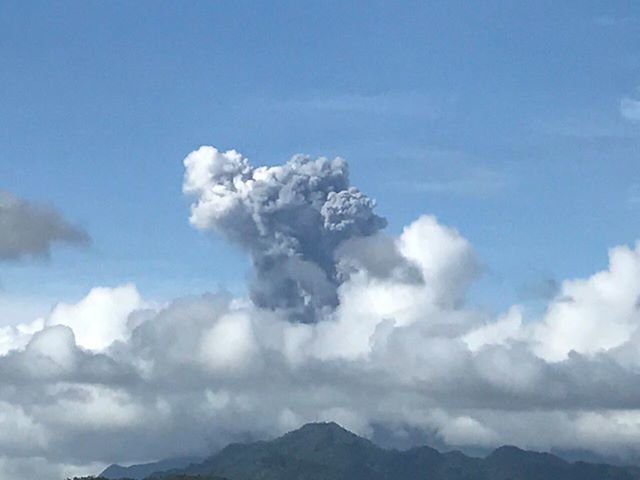
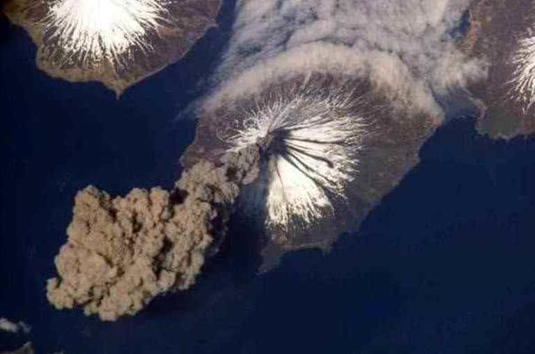
Alaska’s Pavlof volcano eruption
Alaska’s Pavlof volcano erupted unexpectedly on March 27, 2016.
Volcanoes Campi Flegrei in Italy, Sakurajima in Japan, Pavlof in Alaska, Popocatépetl in Mexico and Iturrialba in Costa Rica among others showed signs of reawakening in the last semester of 2016, sounding the alarm among the scientist community that warns about a chain of imminent eruptions.

Throughout history, volcanoes have inspired fear and admiration as well. Vesubio (Italy), Mount Tambora (Indonesia), Laki (Iceland), Mount St. Hellen (USA) and Nevado del Ruiz (Colombia) are just some of the volcanoes that have ravaged entire populations in different periods of time, killing thousands of people and turning vast areas into a desert of fire, ashes and sulfuric gases. But, strange as it may sound, volcano activity has become an item of the so-called eco/adventure tourism, thanks to the unmatched, unique spectacle of lights and sound that offers a moderated eruption.

According to experts, it takes 500 years for a supervolcano to reawaken, even less. And this seems to be the case of Campli Flegrei in the west of Naples, Italy, an extensive volcanic that boasts 24 craters and its cauldron-like depression was formed 39,000 years before as part of the biggest eruption that Europe has experienced in the last 200,000 years.

A team of researchers led by volcanologist Giovanni Chiodini from the Italian National Institute of Geophysics in Rome assures that Campi Flegrei seems to be approaching a critical pressure point, a sign that could be read as announcing of an imminent eruption. The research team says that Campi Flegrai has registered an "uplift" since the last decade, what it means that the volatile gasses inside are rising to the surface at an unexpected rate, turning the alert level from green (or quiet) to yellow (or monitoring mode).

Comment: All around the world earthquake and volcanic activity seems to be increasing.

To understand why this may be happening, read Earth Changes and the Human-Cosmic Connection. Here's a relevant excerpt:
From 1973 to 1996, earthquake and eruption frequencies were almost stable, increasing only slightly year after year, but from 1996 onwards, an acceleration is noticeable. Volcanic eruptions show an increase from about 59 eruptions per year at the end of the 1990s to roughly 75 eruptions per year in the period 2007 - 2010 (+30%).

Today, the increase in volcanic activity has reached such a level that, by late November 2013, 35 volcanoes were actively erupting , including volcanoes that had been dormant for decades.

It could be argued that the increase in both the frequency and intensity of earthquakes and volcanic eruptions is, at least partly, a result of the slowdown and 'opening up' processes:

1) The Earth's minute slowdown exerts mechanical stress on the crust (compression at low latitudes and extension at high latitude). This stress deforms the crust. This deformation is more pronounced and can even lead to partial ruptures around the weakest spots of the crust, i.e. the fault lines (boundaries between tectonic plates) which are the typical location of seismic and volcanic activity.

2) The mantle has a higher density than the crust and therefore has a higher momentum and won't slow down as fast as the crust. The difference in rotation between the crust and the mantle is equal to the crustal slippage. The fluidity of the mantle enables slippage induced by the different momentum carried by the crust, the upper mantle and the core.

This speed difference can cause friction at the interface between the crust and the mantle. This friction can locally deform the crust and cause earthquakes and eruptions.

3) The decrease in the surface - core E-field reduces the binding force and loosens the tectonic plates relative to each other. The plates are then free to move relative to each other. It is this very relative movement (divergence, convergence or sliding) which is one of the main causes for earthquakes and volcanic eruptions:
[Change] in Earth's speed of rotation would induce changes in the magma tide as it adjusted to the new equator or altered rotational speed. Such changes, however, might not be uniform throughout, owing to a 'drag' factor deep in the magma itself, although, overall, they would certainly impose terrible strains on the lithosphere generally.
4) A final factor involved in earthquakes and volcanic eruptions is electromagnetism:
Some scientists have become aware of a correlation between sunspots and earthquakes and want to use sunspot data to help predict earthquakes. The theory is that an intensification of the magnetic field can cause changes in the geosphere [i.e. crust]. NASA and the European Geosciences Union have already put their stamp of approval on the sunspot hypothesis, which suggests that certain changes in the Sun-Earth environment affect the magnetic field of the Earth, which can then trigger earthquakes in areas prone to them. It is not clear how such a trigger might work.


Bizarro Earth

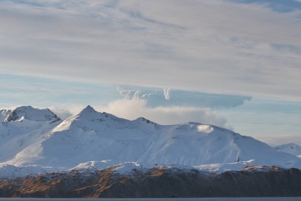
Increased seismic activity at Alaska's Bogoslof volcano

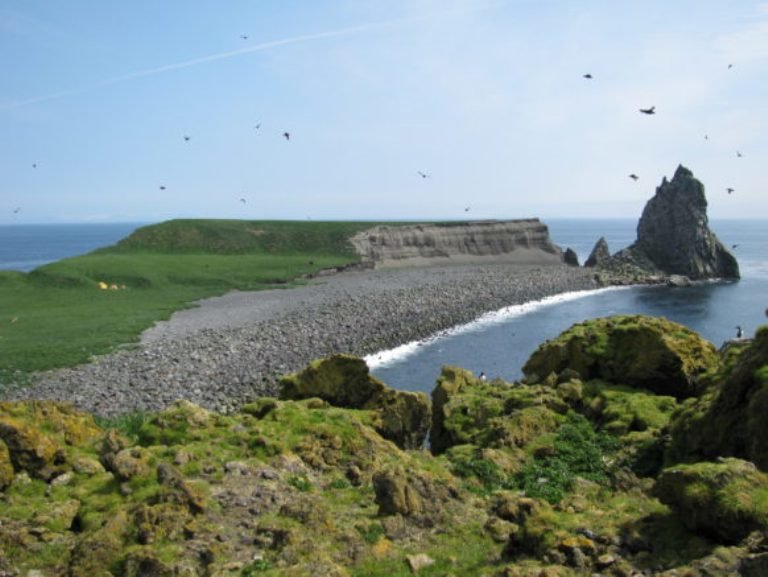
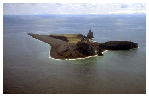
Bogoslof Island
© T. Keith, U.S. Geological SurveyAlthough Bogoslof Island is uninhabited, it is an important breeding ground for sea birds, seals and sea lions.
Seismic unrest continues at Bogoslof volcano. Scientists are watching the eruption around the clock — even though monitoring stations are far from the site.

Chris Waythomas, of the U.S. Geological Survey, is observing a particular indication of increased seismic activity: volcanic tremors.

"You can think of it as the sort of signal you might get if you were to seismically monitor an organ pipe," Waythomas said. "As air moves through the pipe, it resonates. When it impinges on the pipe, it produces motion and that's what we're kind of measuring."

Waythomas said the problem is there's a lot of wind and that can obscure the signal.

"It looked to us like there was increase in this tremor signal," Waythomas said. "We wanted to alert everyone it was possible this could be accompanied by a large steam or ash emission."

The Alaska Volcano Observatory also has access to satellites which they use to look for steam or ash plumes and thermal signals, but cloud cover is making it difficult to confirm.

Bogslof volcano began erupting last week.

Arrow Up

Bulusan Volcano in Philippines spews 2km ash plume

Bulusan volcano eruption
Phreatic eruption at Bulusan volcano at 2:40PM today. Grayish to dirty white eruption plume reached 2,000 meters above the summit.
A two-kilometer-high ash plume formed over Bulusan Volcano in Irosin, on Thursday afternoon, according to the Philippine Institute of Volcanology and Seismology (PHIVOLCS), the latest display of the mountain's continuing restiveness.

The plume was caused by a phreatic eruption that occurred at 2:40 pm and lasted some 16 minutes, according to the agency.

In its Twitter account, PHIVOLCS said that Alert Level 1 (abnormal) remains in effect over Bulusan.

It advised local government units, civil authorities, and the public to avoid entry into the vicinity of the volcano.

Attention

Colima volcano erupts in Mexico; 1.5 mile ash plume

Colima eruption on December 27, 2016.
Mexico's Ministry of Interior said the Colima volcano has generated eruptions that have created ash plumes up to 1,000 feet tall.

Luis Felipe Puente Espinosa, the Interior Ministry's public safety coordinator, said in a statement that the latest eruption occurred early Tuesday, and created an ash plume about 1.5 miles tall. Ash could fall up to 30 miles away from the volcano, he said.

The Colima volcano -- known by Mexicans as the Volcano of Fire -- is in Mexico's Colima state, a small state on the Pacific coast. Authorities have also declared an exclusion zone in neighboring Jalisco state.

"Respect the radius of exclusion of 4.6 miles in Jalisco and 7.4 miles in Colima," the Interior Ministry said in a statement.

The Interior Ministry said ash will mostly affect areas east and west of the volcano, while areas within about three miles of the volcano are at risk of falling volcanic debris.


Attention

2 volcanoes explode into life triggering state of emergency in Peru

Sabancaya volcano
Two volcanoes in Peru have erupted into life, just 60 miles apart sparking widespread fears and authorities have declared a state of emergency and started a mass evacuation.

The Sabancaya volcano started spewing ash and smoke some 3,500 meters (11,500 feet) into the air on Monday, in the latest in a series of worrying explosions in the south of the South American country.

The volcano, situated just 40 miles from Peru's second most populous city Arequipa in the Andes, returned to life at 8.24am on Monday just over a week after it began activity on December 16.

Local authorities have warned the local inhabitants they are likely to be affected by the ash from the 20,000-ft (6,000m) volcano whose name translates at 'tongue of fire' in the local dialect of Quechua.


Attention

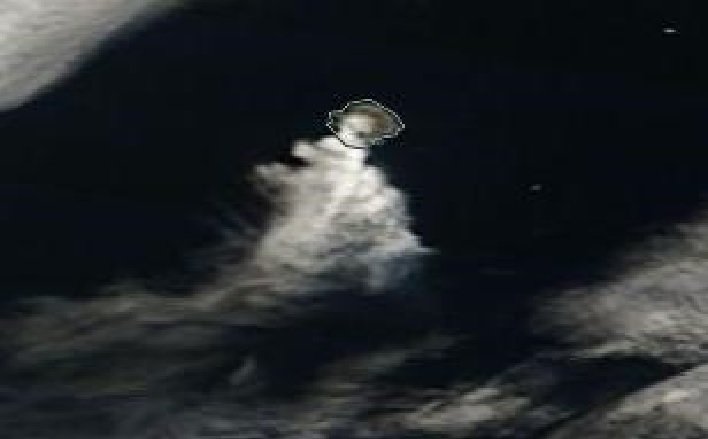
Bogoslof volcano alert raised to red by the Alaska Volcano Observatory

Bogoslof volcano
© NASA Goddard Space Flight CenterBogoslof volcano
The alert level for the Bogoslof volcano was raised to red, the highest rating, after a detection of an ash-producing eruption on Alaska's Aleutian Islands, Alaska Volcano Observatory (AVO) said in a report.

"An ash-producing eruption started at 14:05 AKST (23:05 UTC) today and is continuing as recorded by seismic data on nearby islands, by lightning, and as seen in recent satellite images," the report read.

It also said that one ash cloud reached around 30,000 feet.

The observatory raised the aviation alert level from a watch to a warning, according to the report.

Attention

For second day running, Bogoslof volcano eruption sparks aviation alert in Alaska

A plume rises from Bogoslof volcano, partially obscured by a mountain on Unalaska Island, in this view from Unalaska, about 60 miles east of the volcano, on Wednesday, Dec. 22, 2016.
© Lynda Lybeck-RobinsonA plume rises from Bogoslof volcano, partially obscured by a mountain on Unalaska Island, in this view from Unalaska, about 60 miles east of the volcano, on Wednesday, Dec. 22, 2016.
For the second straight day, the Alaska Volcano Observatory issued its highest alert level for aviation when a volcano erupted with a towering ash cloud in the Aleutian Islands.

Observatory volcanologist Robert McGimsey says Wednesday afternoon's eruption of the Bogoslof volcano was "almost a carbon copy" of an eruption 24 hours earlier.

He tells The Associated Press that both eruptions prompted the highest alert level and both were downgraded hours after the events.

Tuesday's eruption sent ash and steam 34,000 feet into the air, while Wednesday burst went 1,000 feet higher. Officials say both volcanic explosions were also short-lived.

The observatory said early Thursday that it was reducing the alert level because there had been no recent volcano activity.

The volcano is located on an island of the same name in the Bering Sea about 850 miles southwest of Anchorage.

Source: AP

Bizarro Earth

Set to blow? Supervolcano Campi Flegrei reawakening near Naples, could hit 500,000 people

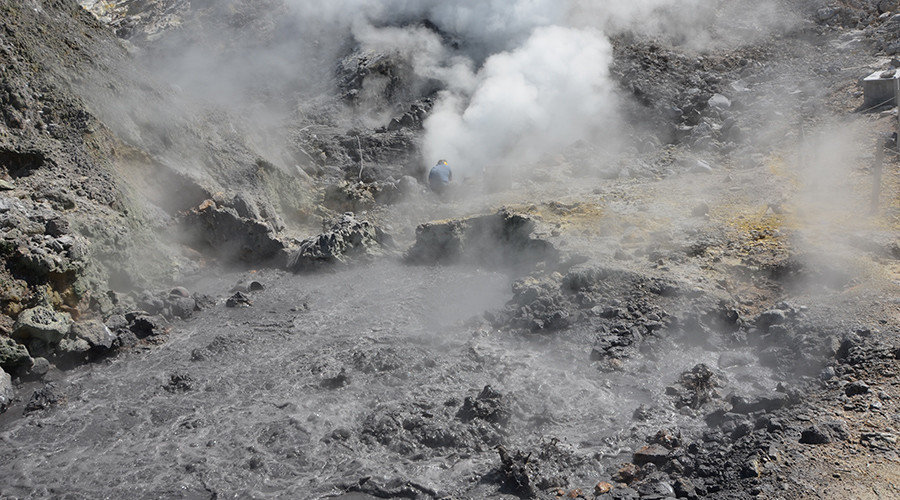
Pisciarelli fumaroles and mud pools from the Campi Flegrei caldera
© Carmine Minopoli / AFPPisciarelli fumaroles and mud pools from the Campi Flegrei caldera, a super volcano, near Naples.
An Italian supervolcano is showing signs of reawakening, with any eruption potentially affecting half a million people, scientists say. The volcano is located across the Bay of Naples from the famous Vesuvius, which saw one of most destructive eruptions in history.

Campi Flegrei, or the Phlegraean Fields, is a large volcanic area located in the metropolitan area of Naples, one of the most densely-inhabited areas in the world, with over 3 million people. The 13km-wide 'caldera', a large cauldron-like depression, lies mostly underwater and has 24 craters and volcanic edifices.

Attention

Bogoslof volcano in Alaska erupts briefly, spews ash cloud 34,000 feet

Bogoslof Island in Alaska
© Ann Harding – AVO/USGSA view of Bogoslof Island in Alaska taken in 2009, with the eroded Castle Rock dome that erupted in 1796.
The Alaska Volcano Observatory has issued its highest level of alert for aviation after what it says was a brief eruption of a volcano on the Aleutian Islands.

The observatory said pilots reported the Bogoslof volcano on Bogoslof Island erupted about 4:00pm Alaska time.

The Aleutian Islands are a chain of volcanic islands in the Bering Sea, belonging to both the United States and Russia.

The pilots told the observatory that a volcanic ash cloud rose to 34,000 feet.

A red alert was issued, which the observatory defines as a hazardous eruption being imminent, underway or suspected.

The observatory said that satellite data show a short-lived explosion just before 4:00pm local time that drifted to the south about 15 minutes later.

Comment: The last recorded eruption of Bogoslof was in 1992. The Aleutian Islands, with their 57 volcanoes, are in the northern part of the Pacific Ring of Fire, a region prone to frequent earthquakes and volcanic eruptions.

Ring of Fire
© Wikimedia Commons


Attention

Two volcanoes erupt on South Sandwich Islands

A plume originating from Mount Curry on Zavodovski Island is drifting then dispersing to the south-southwest.
© Terra/MODIS/NASA.A plume originating from Mount Curry on Zavodovski Island is drifting then dispersing to the south-southwest.
On 17th December 2016, two plumes appear in satellite images. One originating from Zavodovski Island, and the other from Saunders Island.

In the image of Zavodovski Island, a white plume originating from the summit crater of Mount Curry is seen drifting in a south-southwesterly direction before dispersing. It's more likely to be a gas plume although I wouldn't rule out the possibility of some slight ash content.

In the image of Saunders Island, a greyish plume originating from the summit crater of Mount Michael is seen drifting towards the northeast. A thermal anomaly was also detected on the summit area of Mount Michael. This indicates that it's likely to be an eruption occurring on Mount Michael Volcano.

What is likely to be an ash plume from Mount Michael on Saunders Island.
© Aqua/MODIS/NASA.What is likely to be an ash plume from Mount Michael on Saunders Island.