Extreme Temperatures
S


Ice Cube

Iceberg the size of London calves off Antarctica - Caused by a glacier EXPANDING, not melting

Antarctica iceberg calving
© COPERNICUS DATA/SENTINEL-1
An iceberg the size of greater London (1,636 km2) has just snapped off the Amery ice shelf in east Antarctica. And while alarmists will be blindly clamoring to link the event to global warming, the facts tell an entirely different story.

Ice shelves are essentially floating extensions of glaciers that hold back the flow of ground ice.

When an iceberg breaks off an ice sheet it is known as 'calving'.

Calving is a form of ice ablation or ice disruption, and is caused by a glacier EXPANDING, not melting.

Kelly Brunt, a glaciologist with Nasa and the University of Maryland, explained "the process of formation was a bit like a fingernail growing too long and cracking off at the end."

Ice bergs calving is due to a glacier GROWING
© www.AntarcticGlaciers.orgIce bergs calving is due to a glacier GROWING.

Comment: See also:


Snowflake

Ice Age Farmer Report: Historic "Freak" Sept. blizzard - Global wheat output drops - Grand Solar Minimum

snow reports
A record-breaking snowstorm and record cold temperatures are causing many to ask, what of the "warmest year ever?" -- as wet fields prevent harvest and planting of winter crops. Start growing your own food today.


Sources

Snowflake

Sunday's September snowfall broke records in Alberta - up to 3 feet reported

snow
© LaraFominoff / Twitter
Well, that was one for the books - literally.

After numerous snowfall warnings were issued across the prairies for this past weekend, Old Man Winter showed up with a vengeance.

According to the Weather Network, blizzard-like conditions brought the white stuff to southern Alberta and across southern Saskatchewan all through the weekend, with the worst of it touching down on Sunday.

So just how much snow fell, you ask?

In Waterton National Park, a total of 95 cm of snowfall was recorded. At Chain Lakes, it was 54 cm. Even the City of Lethbridge saw snowfall amounts of up to 55 cm.


Snowflake

Springtime snowfall over mountains in South Africa brings big chill

Light snow fell over Sani Pass, between KZN and Lesotho, on Monday.
© Aaron RadomskyLight snow fell over Sani Pass, between KZN and Lesotho, on Monday.
Parts of the Drakensberg are being sprinkled with snow and more is expected on Tuesday.

The SA Weather Service (Saws) told TimesLIVE that the southern part of the mountain range received light snow on Monday.

"We haven't seen anything above 2cm. We have on and off snowfall the entire day for Lesotho and the southern Drakensberg," said Wayne Venter, a Saws forecaster.

"It looks like some good snowfall in the northern and northeast Drakensberg, on the KwaZulu-Natal border side."

Snowflake

Flake news: Parts of Montana hit by winter storm dumping 4 FEET of snow!! Drifts of 7 FEET reported (UPDATE)

September snow in Montana
Feet of snow have fallen and powerlines are down in the Rockies -- and it's only September.

A winter storm is blowing through parts of the region this weekend, just days after the start of fall.

So far, parts of Montana have received almost two feet of snow. Browning was blanketed by 23 inches and East Glacier Park by 21.

The National Weather Service's winter storm warning for portions of north central Montana is in effect until Monday morning. CNN meteorologist Ivan Cabrera said in that time, another one to two feet of snow may fall.

Great Falls, Montana got a preliminary 9.7 inches of snow Saturday, which will set a new daily snowfall record. That number would beat the previous record in 1954 by 3.6 inches.


Comment: Update: WeatherNation reports:
A powerful early season winter storm continues to impact the Northern Rockies. Several locations have already picked up over a foot of snow! Browning, MT has been buried under almost three and a half feet of snow since Friday. That's over two-thirds of their average annual snowfall....and it's still snowing.

chart
Snow will continue into Monday morning. This snow is wet which means it is also heavy. This puts a strain on trees and power lines. Tree damage and power outages are still likely this evening. Travel will remain hazardous through the night and early Monday. If possible, stay home until the storm settles late-morning Monday.

snow map


See in addition: Now snowing heavily in 8 states and 5 provinces in North America - in September

Update: USA TODAY reports on September 30th:
Kids in Browning, Montana, were gifted with that rare September snow day Monday after a historically early winter storm pounding parts of the West dumped four feet of snow on the town in the heart of the Blackfeet Reservation.

Barely a week after the end of summer, snow swept across parts of California, Oregon, Washington, Montana, Idaho, Nevada and Utah. The National Weather Service said temperatures in some areas were dropping as much as 30 degrees below normal.

A combination of factors contributed to the wintry blast, AccuWeather Senior Meteorologist Alex Sosnowski said.

"A storm from the Pacific Ocean, a fresh injection of cold air from northern Canada, moisture from the Gulf of Mexico and a northeast-ascending flow that squeezed extra moisture from the atmosphere produced the amazing snowfall," Sosnowski said.

Montana got the worst of it, and Gov. Steve Bullock declared a winter storm emergency. Great Falls, which normally sees less than 2 inches of snow in September, was blasted with a two-day snow total of 19.3 inches - the second-highest two-day snow total ever for any time of year.

Near-record cold was forecast for Monday night.

Dupuyer, 40 miles southeast of Browning, saw 37 inches of snow. Browning took the dubious top honors, although AccuWeather senior meteorologist Dan Pydynowski told USA TODAY less populated areas doubtlessly were slammed with more than 4 feet, but it just won't ever be measured.

"Browning Schools has cancelled all classes for tomorrow 9/30/19 to dig out from the storm," the school tweeted Sunday. It was not immediately clear whether one day of digging would be enough.

Snow drifts as high as 7 feet were reported. Sosnowski also warned that unseasonably cold conditions will delay snowmelt in some areas and halt the growing season for some farmers. The hard freeze could bring added pain to farmers already dealing snow-covered fields, he said.

Snowbanks were so high in some areas of Montana they reached the roofs of houses.
SNOW
Sosnowski said September snow in parts of the U.S. isn't that unusual, but the amount of snow at relatively low elevations is. The cold was also a surprising feature.

"Many daily record low maximum temperature records are possible through Monday, especially across the Northern Great Basin, Rockies and Northern California," the weather service said.

More than a foot of snow fell in parts of northeastern Washington. Spokane got the city's first recorded September snow since 1926.

The National Weather Service said Sunday was a record-breaking day in Oregon and Washington. For some locations, it was the coldest September day since 1948.

Portland International Airport tied its coldest September high temperature on Sunday, matching a temperature from 1948. The winter of 1948-49 was one of the coldest on record for the Portland area - and the airport had 22 inches of snow that winter.

"Correlation or coincidence...?" tweeted the National Weather Service office in Portland. "Probably coincidence, but I guess we'll find out."


Snowflake

Heavy snowfall in north Sweden leads to weather warning

Snowfall in Kiruna on Monday.
© Selam Nahom NoahSnowfall in Kiruna on Monday.
It's still only September, but heavy snowfall in the far north of Sweden has led to an official weather warning, and even the south of the country can expect wintery weather in the next few days.

In Jukkasjärvi, Norrbotten, 14 centimetres of snow were measured on Monday morning after overnight snowfall. A class-one weather warning (the lowest level on a three-point scale) was still in place in the afternoon after first being issued by meteorological institute SMHI on Sunday.

Kiruna resident Selam Nahom Noah shared photos and videos of the wintery weather on The Local's Facebook group Living in Sweden.

Several areas of the rest of the country were affected by a low pressure area which led to cloudy weather and some rainfall. Temperatures were up to 15C in southernmost Sweden and single digits in the north, with some parts of the northern mountain ranges dropping into minus figures.


Snowflake

Now snowing heavily in 8 states and 5 provinces in North America - in September

snow
© Karen Manzer ‏
This will be a "Major To Historic Winter Storm in the northern Rockies," warns the National Weather Service.

"A powerful storm system will produce several feet or more of wet, heavy snow; and gusty winds in the Northern Rockies," says the NWS. "Snow is also forecast along the Rocky Mountain Front, portions of the Great Basin, and other northwestern Mountains. Trees with leaves will be vulnerable to damage. Heavy snow and strong winds will make travel difficult to impossible in places."

The trees are still fully loaded with foliage, so the strong winds and heavy, wet snow is expected is to bring down trees and power lines leading to widespread power outages.

As of Sunday morning, accuweather.com weather maps showed snow or snow showers in Washington, Oregon, Nevada, Idaho, Utah, Montana, Wyoming, North Dakota, British Columbia, Alberta, Saskatchewan, Manitoba and Ontario.


Comment: Related: Flake news: Parts of Montana hit by winter storm dumping 3 FEET of snow!! (UPDATE)


Snowflake

A 'historic' winter storm will blast the northern Rockies this weekend

US snow forecast
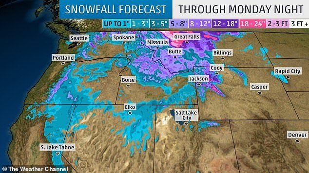
© The Weather ChannelUp to 50 inches of snow are expected to fall in Western Montana, while winter storm watches have been issued in eastern Washington, the Idaho panhandle and northwestern Wyoming
It's the very beginning of fall and the northern Rocky Mountains are bracing for a significant winter storm that could pummel the mountains with feet of snow and blizzard conditions this weekend.

"This has the potential to be a historically significant early-season snow event," the National Weather Service in Great Falls, Montana, said.A cold front with strong winds and near-record cold air will move through Idaho and Montana on Friday. It will be followed by another low-pressure system that will stall over the region Friday night through Sunday.

With unseasonably cold air already in place, wet, heavy snow is likely from the valleys to the mountain tops.The forecast for this storm looks eerily similar to a storm that struck Montana in 1934. That storm produced prolific amounts of snow in late September over North Central Montana.

This weekend, a few inches to feet of snow could fall across the region. The impacts will start tonight along the Continental Divide.

By Monday, the mountains will have storm totals being measured in feet. Areas near Glacier National park will see two to three feet of snow.Snow won't start to accumulate in most of the valleys until Saturday night.

Since this is an early season storm and the ground is still warm, most of the first snow to fall will likely melt. In some lower elevations, it may not even accumulate.

Snowflake

Early snowfall in Alaska

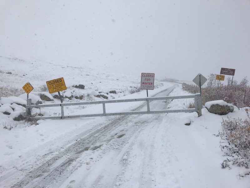
Hatcher Pass was hit by its first significant snow storm! The road over the summit has been closed for the season
© Alaska Department of Transportation & Public FacilitiesHatcher Pass was hit by its first significant snow storm! The road over the summit has been closed for the season
Snow has come to the Yukon-Kuskokwim Delta. In Emmonak, resident Lilly Westlock estimates that over an inch fell on Tuesday evening.

"First time I've seen snow falling in September," she said. "The snowflakes were kind of bigger than usual, and it stayed for the evening, and then it started raining and melted."

Westlake says that the snow began around 5 p.m. when she was leaving work. On the way to a friend's house she passed a little girl playing in the snow.


Snowflake

Yup, it snowed in Flagstaff, Arizona on the first day of fall

snow
The first day of fall in Arizona brought with it a buffet of weather: rain, wind, a tornado, and even snow!

Nearly all parts of the state -- northern Arizona, the Phoenix area, and southern Arizona -- saw rain and thunderstorms on Monday. More than three inches fell in some parts of the Phoenix area. Viewer video captured what appears to be a tornado in the New River area. Parts of the east Valley saw flooding.

And in Flagstaff, snow fell on the San Francisco Peaks, according to the National Weather Service in Flagstaff, and at Arizona Snowbowl.

"Yes, it did snow on the San Francisco Peaks this afternoon!" according to a tweet from NWS Flagstaff. "Our best estimate is that snow and graupel fell down to 11000-11500 feet and probably got several inches deep at the highest elevations."