Earthquakes
S


Bizarro Earth

Japan's massive 2011 earthquake may trigger more, and larger, volcanic eruptions

Image
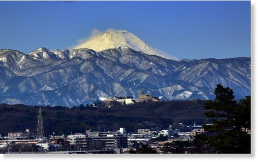
© AFP Photo/Yoshikazu TsunoSnow-covered Mount Fuji is seen from Tokyo, Japan, on February 16, 2014
Japan's massive 2011 earthquake may trigger more, and larger, volcanic eruptions over the next few decades, perhaps even that of Mount Fuji - but predicting them remains close to impossible, a volcano expert said on Friday.

The nation last month suffered its worst volcanic disaster in nearly 90 years when Mount Ontake, its second tallest active volcano at 3,067 meters (10,062 feet), suddenly erupted, raining down ash and stone on hikers crowding the summit.

The eruption killed 56 people, exceeding the deaths in the 1980 eruption of Mount St Helens in the United States. Seven victims remain missing, and recovery efforts have been suspended until the spring.

Japan may well be moving into a period of increased volcanic activity touched off by the 9.0 magnitude earthquake of March 11, 2011, said Toshitsugu Fujii, a volcanologist and professor emeritus at the University of Tokyo.

"The 2011 quake convulsed all of underground Japan quite sharply, and due to that influence Japan's volcanoes may also become much more active," Fujii told reporters.

"It has been much too quiet here over the last century, so we can reasonably expect that there will be a number of large eruptions in the near future."

Bizarro Earth

Four San Francisco fault lines have built up enough seismic strain to unleash destructive earthquakes

northern california fault lines
San Francisco Bay Area earthquake faults are drawn in red.
With several faults slicing through the San Francisco Bay Area, forecasting the next deadly earthquake becomes a question of when and where, not if.

Now researchers propose that four faults have built up enough seismic strain (stored energy) to unleash destructive earthquakes, according to a study published today (Oct. 13) in the Bulletin of the Seismological Society of America.

The quartet includes the Hayward Fault, the Rodgers Creek Fault, the Green Valley Fault and the Calaveras Fault. While all are smaller pieces of California's San Andreas Fault system, which is more than 800 miles (1,300 kilometers) long, the four faults are a serious threat because they directly underlie cities.

Bizarro Earth

4 Northern California faults primed for major earthquakes

Image
In this Aug. 24, 2014, file photo, pedestrians examine a crumbling facade following an earthquake at the Vintner's Collective tasting room in Napa, Calif.
Three fault segments running beneath Northern California and its roughly 15 million people are overdue for a major earthquake, including one section that lies near the dams and canals that supply much of the state's water, according to a geological study published Monday.

The three fault segments and one other in the region are loaded with enough tension to produce quakes of magnitude 6.8 or greater, according to a geological study published Monday.

They include the little-known Green Valley fault, which lies near key dams and aqueducts northeast of San Francisco. Underestimated by geologists until now, the fault running between the cities of Napa and Fairfield is primed for a magnitude-7.1 quake, according to researchers from the U.S. Geological Survey and San Francisco State University.

The water supplies of the San Francisco Bay Area, Southern California and the farm-rich Central Valley depend on the man-made water system that links to the Sacramento and San Joaquin rivers, noted James Lienkaemper, the U.S. Geological Survey geologist who was lead author of the study. The Green Valley fault is last believed to have ruptured sometime in the 1600s.

Bizarro Earth

El Salvador magnitude 7.4 temblor strikes off coast

A powerful earthquake hit late Monday off the Pacific coast of El Salvador, the U.S. Geological Survey reported. The temblor was recorded about 66 miles south-southeast of the city of Usulutan with a preliminary magnitude of 7.4

An earlier report from the NWS Pacific Tsunami Warning Center said "hazardous tsunami waves" were possible along the coasts of Nicaragua, Honduras and El Salvador. That report was later amended to note that there was "no longer a tsunami threat."

The USGS also issued a "yellow alert" for possible shaking-related fatalities and economic losses. Wilfredo Salgado, mayor of the city of San Miguel in El Salvador, said on his Twitter account that a man was killed when an electricity post fell on him. He also posted images of damage in the area:
Image
© Will Salgado via TwitterGrandes roca obstruyen gran parte de carretera entre Santiago de María y Alegría, Usulután; es en curva El Cuyapo pic.twitter.com/hRwMNtAzp7”
Additional images
USGS data

Bizarro Earth

Is New England's seacoast ready for an earthquake?

Image
© Northeast States Emergency ConsortiumSince 1975 moderate size earthquakes have occurred in New Brunswick, New Hampshire, northern New York and Quebec.
"Drop, cover and hold on."

It's a message that likely hasn't reached most New Englanders who rarely worry about the dangers of a major earthquake happening here. But the threat is real.

"Definitely the risk in this area is significantly greater than most people think," said Margaret Boettcher, an assistant professor of geophysics at the University of New Hampshire who has researched the physics of earthquakes and the mechanics of fault slip.

Seacoast emergency officials agree there is a danger and people should take it seriously. While strong earthquakes are rare here, history has shown that they can happen and could pose a significant threat to many of the region's historic buildings that were constructed long before codes were put in place to protect against seismic activity. The old brick buildings in places like Exeter and Portsmouth are at greatest risk, officials say.

Bizarro Earth

USGS: Earthquake Magnitude 6.1 - South of the Kermadec Islands

Kerdamec Quake_141014
© USGS
Event Time
2014-10-14 04:12:30 UTC
2014-10-14 16:12:30 UTC+12:00 at epicenter

Location
34.917°S 179.970°E depth=31.5km (19.6mi)

Nearby Cities
400km (249mi) SSW of L'Esperance Rock, New Zealand
430km (267mi) NE of Whakatane, New Zealand
450km (280mi) NNE of Gisborne, New Zealand
459km (285mi) NE of Tauranga, New Zealand
840km (522mi) NE of Wellington, New Zealand

Scientific Data

Bizarro Earth

USGS: Earthquake Magnitude 7.3- 67km WSW of Jiquilillo, Nicaragua

Jiquilillo Quake_141014
© USGS
Event Time
2014-10-14 03:51:35 UTC
2014-10-13 21:51:35 UTC-06:00 at epicenter

Location
12.576°N 88.046°W depth=40.0km (24.9mi)

Nearby Cities
67km (42mi) WSW of Jiquilillo, Nicaragua
86km (53mi) SSW of La Union, El Salvador
95km (59mi) W of Corinto, Nicaragua
95km (59mi) SSE of San Rafael Oriente, El Salvador
174km (108mi) SE of San Salvador, El Salvador

Scientific Data

Bizarro Earth

USGS: Earthquake Magnitude 4.0 - Near Mammoth Lakes, California

Image
© USGS
Event Time
2014-10-13 00:13:50 UTC
2014-10-12 17:13:50 UTC-07:00 at epicenter
014-10-12 17:13:50 UTC-07:00 system time

Location

37.475°N 118.783°W depth=7.1km (4.4mi)

Nearby Cities
25km (16mi) SE of Mammoth Lakes, California
108km (67mi) NE of Clovis, California
108km (67mi) NE of Sanger, California
113km (70mi) NNE of Reedley, California
206km (128mi) SSE of Carson City, Nevada

Scientific data

Comment: Nearly 3 dozen small quakes in 24 hours - Volcanic unrest at Mammoth Lakes?


Bizarro Earth

USGS: Earthquake Magnitude 6.3 - 154km ENE of Hachinohe, Japan

Hachinohe Japan Quake_111014
© USGS
Event Time
2014-10-11 02:35:46 UTC
2014-10-11 12:35:46 UTC+10:00 at epicenter

Location

40.986°N 143.216°E depth=13.5km (8.4mi)

Nearby Cities
154km (96mi) ENE of Hachinohe, Japan
160km (99mi) ENE of Misawa, Japan
165km (103mi) SSE of Shizunai, Japan
171km (106mi) E of Mutsu, Japan
663km (412mi) NNE of Tokyo, Japan

Scientific Data

Blue Planet

6.3 earthquake off northern Japanese coast as Typhoon Vongfong hits Okinawa

japan quake
© Google Maps
A 6.3 earthquake has been registered early Saturday off Japan's northern coast by the US Geological Survey. The quake comes as the world's biggest super-typhoon this year, Vongfong, is striking the south of the country.

The tremor occurred at 02:36 GMT, the Japan Meteorological Agency reported. There have been no reports of damage, casualties or a tsunami alert.

The epicenter of the quake was located 154 kilometers away from the southeastern city of Hachinohe, in Japan's southeast Aomori Prefecture, at a depth of 13 kilometers.

Comment: In a spade of only two weeks, the Japanese have faced tropical storm Kammuri, the violent eruption of Mt Ontake volcano, two earthquakes near the Fukushima nuclear plants, and before typhoon Phanfone made its way out, typhoon Vongfong came in!