Earthquakes
S


Megaphone

Indonesia: 7.3 quake with potential tsunami

map Moluccas
© www.businessinsider.comSite of 7.3 earthquake near Ternate island, Moluccas.
A major earthquake with a magnitude of 7.3 was recorded off the Moluccas in Indonesia on Saturday, the national disaster mitigation agency said, causing residents near the quake to flee their homes after a tsunami warning was issued.

The earthquake was felt strongly on the Sitaro islands, where authorities also warned people to stay away from beaches and riverbanks, Sutopo Purwo Nugroho, a spokesman at Indonesian agency, said in a statement. There were no reports of casualties or major damage. MetroTV reported power cuts in some parts of Manado, the capital of North Sulawesi province.

"It was strong," said Regina Saerang, an eyewitness in Manado. "I felt it for about a minute. There was no damage but people on my street are pouring out of our houses." The head of the disaster mitigation agency had ordered the preparation of aircraft and logistics in case they were needed and further checks of the affected areas were being made, Nugroho said.
equake bubbles
© www.abc.net.auThe earthquake parameters provided by the Pacific Tsunami Warning Center
The Pacific Tsunami Warning Center in Hawaii said hazardous tsunamis were possible within 300 km (185 miles) of the quake's epicenter, although there was no danger of a Pacific-wide tsunami.

It had also warned that tsunamis could be expected to reach Indonesia, the Philippines, Palau, Papua New Guinea, the Solomon Islands and the Marshall Islands, and even as far away as Taiwan and Japan's Okinawa. The first waves could reach land within 30 minutes and the last within about six hours. "The initial wave may not be the largest," the center warned.

Comment: Based on USGS data, earthquake frequency has risen sharply by more than 30% since the 1990s. There is a strong correlation proven between earthquakes and sunspots. An intensification of the magnetic field has implications for Earth's crust, triggering earthquakes. Precursors that indicate alerts of this potential rise also include increases in: low frequency electromagnetic emission, magnetic field anomalies, earthquake lights from ridges and mountain tops, temperature anomalies over wide areas and changes in plasma density of the ionosphere. While we think of rocks as being poor conductors of electricity, there are times when this is the reverse, as when under severe stress from the slowing down of earth rotation, the reduction in gravity that allows for an "opening up" phenomenon that increases the chances for strong earthquakes, and the reshaping of Earth from more ovoid to spherical. The Pacific Rim has proved to be one of the most regions conducive to the rising magnitude levels and frequencies of major earthquakes of late.*

Earth Changes and the Human Cosmic Connection: The Secret History of the World - Book 3


Bizarro Earth

Magnitude 5.6 earthquake strikes Peruvian coast near Lima

5.6 earthquke peru november 15 2014
A 5.6 magnitude earthquake struck the Pacific near the Peruvian coast late on Friday, rocking buildings for several seconds in the capital Lima and disrupting cellphone services briefly.

There were no immediate reports of damages or injuries.

The quake hit 7.45 miles (12 kilometers) southwest of Mala, a coastal town near Lima, at a depth of 28.8 miles (46.4 kilometers), according to the U.S. Geological Survey.

Peru's Geophysical Institute, which measures earthquakes on the Richter scale, initially reported a magnitude of 5.8.

Peru's Navy said on Twitter that the quake did not trigger tsunami alerts.

Bizarro Earth

USGS: Earthquake Magnitude 7.1 - 156km NW of Kota Ternate, Indonesia

Kota Ternate Quake_151114
© USGS
Event Time
2014-11-15 02:31:40 UTC
2014-11-15 10:31:40 UTC+08:00 at epicenter

Location
1.928°N 126.547°E depth=35.0km (21.7mi)

Nearby Cities
156km (97mi) NW of Kota Ternate, Indonesia
156km (97mi) NW of Ternate, Indonesia
160km (99mi) ENE of Bitung, Indonesia
164km (102mi) W of Tobelo, Indonesia
1064km (661mi) SW of Koror Town, Palau

Scientific Data

Bizarro Earth

NW Nevada earthquake swarm that began in July now intensifying

earthquake swarm nevada
Swarm of recent earthquakes in NW Nevada, southeast of Lakeview, has scientists watching closely, though not overly worried
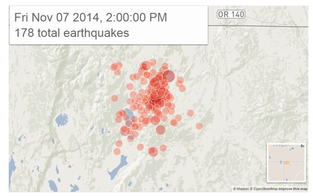
An earthquake swarm that started rocking a secluded region in northwest Nevada this summer intensified over the past week, geology officials said on Wednesday.

The swarm, centered just off the state's northwest border some 40 miles (65 km) southeast of Lakeview, Oregon, started July 12 and is being caused by stretching of the Earth's crust, said Graham Kent, the director of the Nevada Seismological Laboratory at the University of Nevada, Reno.

The laboratory said in a statement that two magnitude 4.7 quakes, and over 50 magnitude 3 or stronger temblors have occurred over the past week, representing more seismic activity than in recent months combined.

Arrow Down

4.8 earthquake in Kansas shakes up residents across Oklahoma

Image
M4.8 - 13km S of Conway Springs, Kansas
A large earthquake that originated in Kansas was felt by residents across Oklahoma, Wednesday afternoon.

The 4.8 magnitude temblor rumbled at 3:40 p.m., eight miles to the south of Conway Springs, Kansas, or about 124 miles north of the Oklahoma City metro, at a depth of three miles.

Several viewers called and wrote in to News 9 reporting to have felt the quake, some even as far south as Norman, Okla. So far there have been no reports of damage or injuries related to this earthquake.

According to the United States Geological Survey (USGS), earthquakes with magnitudes ranging from 2.5 to 3.0 are generally the smallest ones felt by humans. Damage is more likely with earthquakes at magnitudes 4.0 and higher.

Alarm Clock

USGS: Earthquake Magnitude 6.1 - 74km SW of Ile Hunter, New Caledonia

Earthquake 6.1 New Caledonia
© USGS
Event Time
2014-11-10 10:04:21 UTC
2014-11-10 21:04:21 UTC+11:00 at epicenter

Location

22.775°S 171.445°E depth=10.0km (6.2mi)

Nearby Cities
74km (46mi) SW of Ile Hunter, New Caledonia
478km (297mi) ESE of We, New Caledonia
503km (313mi) E of Mont-Dore, New Caledonia
516km (321mi) E of Noumea, New Caledonia
518km (322mi) E of Dumbea, New Caledonia

Scientific data

Attention

Earthquake swarm in Nevada desert intensifying

Image
© LA Times
A swarm of hundreds of earthquakes that has been striking a corner of the Nevada desert near the Oregon border for months has intensified in recent days, prompting new warnings from seismologists.

About 750 earthquakes, mostly magnitude 2.0 to 3.0, have struck the area about 50 miles southeast of Lakeview, Ore., since the swarm started in July, said Ian Madin, chief scientist for Oregon's Department of Geology and Mineral Industries.

The temblors have been growing steadily stronger with time. Six earthquakes of magnitude 4.0 or greater have struck the area since Tuesday and about 40 have struck in the last 24 hours, Madin said.

"This week it has just gone crazy," Madin said.

The swarm is beneath an uninhabited part of the Nevada desert near the Sheldon National Wildlife Refuge, but officials are telling the public, especially the almost 2,300 residents of Lakeview, to develop earthquake plans if they haven't already.

"If you are not ready for an earthquake, now is an awfully good time to get ready for an earthquake," said Alison Ryan, a spokeswoman for the department.

Scientists believe groundwater is slowly percolating along the faults and building up pressure, making movement on the faults much easier, said John Vidale, director of the Pacific Northwest Seismic Network at the University of Washington.

Comment: For more on what's really going on with the increasing earth changes, their cosmic origins and humanity's role in them, read Earth Changes and the Human-Cosmic Connection by Pierre Lescaudron and Laura Knight-Jadczyk.
"While official science portrays the crazy weather, more frequent sinkholes, increased meteor fireball activity, and intensifying earthquakes as phenomena that are unrelated, research put together by Pierre and Laura strongly suggests that all this (and more!) is intimately connected and may stem from a common cause.

In times past, people understood that the human mind and states of collective human experience influence cosmic and earthly phenomena. How might today's 'wars and rumors of wars', global 'austerity measures', and the mass protest movements breaking out everywhere play into the climate 'changing'?"
You can listen to or read the transcript of the SOTT editor's interview with the authors here.

Bizarro Earth

USGS: Earthquake Magnitude 6.6 - 72km NNE of Finschhafen, Papua New Guinea

Finschhafen Quake_071114
© USGS
Event Time
2014-11-07 03:33:54 UTC
2014-11-07 13:33:54 UTC+10:00 at epicenter

Location
6.044°S 148.210°E depth=43.2km (26.8mi)

Nearby Cities
72km (45mi) NNE of Finschhafen, Papua New Guinea
154km (96mi) ENE of Lae, Papua New Guinea
214km (133mi) NE of Bulolo, Papua New Guinea
218km (135mi) NE of Wau, Papua New Guinea
392km (244mi) NNE of Port Moresby, Papua New

Scientific Data

Bizarro Earth

Another 4.9 magnitude earthquake hits Oregon/Nevada border after continuous earthquake swarms since July

Image
© USGS
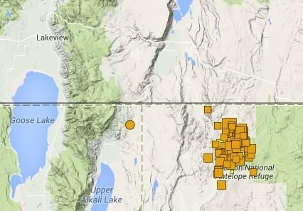
A magnitude 4.9 earthquake rippled beneath the desert floor about 40 miles east/southeast of Lakeview late Tuesday night on the Oregon/Nevada border, the U.S. Geological Survey said. The quake was followed by a series of smaller quakes in the same general area. Four people reported feeling it; the nearest person was in Cedarville, California, about 45 miles west.

USGS geophysicist Randy Baldwin says the Black Rock Desert area has had several minor quakes in the last few months. Seismologists with the Nevada Seismological Laboratory have been tracking swarms of earthquakes in the area since July.

Nevada is the third most seismically active state in the nation behind California and Alaska.

USGS list of earthquakes in most recent swarm

Bizarro Earth

Turrialba Volcano in Costa Rica shaken by violent eruption, ash reaches province of Limón

Image
© The Tico TimesA site near the Turrialba Volcano’s crater.

Among the observations by volcanologists conducting weekend inspections in the area around Costa Rica's Turrialba Volcano were craters in the earth measuring up to one meter in diameter - the result of rocks shooting out from the volcano.

Experts from the National Seismological Network (RSN) and the Volcanological and Seismological Observatory of Costa Rica (OVSICORI) conducted the inspections in light of significant activity at the volcano that started last week.

RSN volcanologist Gino González Ilama said the areas of impact are located on the south side of the volcano and cover 80 percent of the slope up to 400 meters from the volcano's crater.

"We observed the impact of volcanic rock that had caused several craters on the ground. We believe the rocks were shot out of the volcano at speeds greater than 100 kilometers per hour, and this proves there is strong activity inside," González said.