Earthquakes
S


Bizarro Earth

Magnitude 6.3 earthquake strikes Sichuan province in China

earthquake sichuan province
Magnitude 6.3 earthquake strikes remote region of Sichuan province
An earthquake of magnitude 6.3 hit a remote part of China's southwestern Sichuan province on Saturday, with one death reported so far, the official Xinhua news agency said.

The quake struck more than 40 km from Kangding town at 4:55 p.m., at a depth of about 18 km, according to information from the China Earthquakes Network Centre.

The quake caused buildings to shake violently and an elderly woman was killed after being hit by broken glass.

Residents of Chengdu, the provincial capital, also felt the quake strongly.

Earthquakes frequently strike in China's southwest. A quake in Sichuan province in 2008 killed almost 70,000 people.

Bizarro Earth

Central Japan hit by 6.8-magnitude earthquake

Image
A 6.8-magnitude earthquake has hit central Japan at a shallow depth of 10 kilometres, Japan's Meteorological Agency reports. No tsunami warning has been issued.

The quake struck at 22:08 local time (13:08 GMT) and was centered in the Nagano Prefecture on the main island of Honshu, about 16 kilometers northeast of the city of Omachi.

An official from the village of Ogawa, near the epicenter of the quake, told Japan's NHK broadcaster that the residents felt a long shake and saw documents falling off the shelves.
Magnitude 6.8 Intensity 6- earthquake 22:08 Nov-22 JST at Nagano-ken Hokubu (36.7N/137.9E) Depth 10 km http://t.co/rgy1dqBnov #earthquake

- Japan Earthquake (@jEarthquake) November 22, 2014
The authorities from Nagano Prefecture haven't reported any casualties or damage yet.

According to the USGS, the quake was registered at a magnitude of 6.2 on the Richter scale.
長野市やばい。家ぐっちゃぐちゃ。震度6弱の脅威。 pic.twitter.com/ouJ3SzQZEw:HygNtoLuv63

- ニュースな話題つぶやき@移転作業 (@new_2_twit) November 22, 2014
The tremor was felt as far away as the capital, Tokyo, which is about 170 kilometers northwest of the epicenter. The JMA said there was no direct threat of a tsunami after the quake. The cities of Hotaka and Suzaka, also in Nagano Prefecture, are also in proximity of the tremors - 33 and 36 kilometers away, respectively.

Attention

A second major earthquake off Indonesia this week: Magnitude 6.9

A shallow 6.9 magnitude earthquake struck at sea 96 miles northwest of Ternate in the Indonesian Moluccas on Friday, the U.S. Geological Survey said.

There was no threat of a tsunami, the Pacific Tsunami Warning Center said. The quake was only 6.2 miles deep.

A 7.3 quake was recorded off the Moluccas on Saturday, causing residents near the quake to flee their homes.

Indonesia is located inside the so-called "Pacific Ring of Fire," a seismically active zone where different plates of the earth's crust meet and create a large number of earthquakes and volcanoes.

(Reporting by Nick Macfie; Editing by Jeremy Laurence)

Comment: The 7.3 earthquake that struck off Indonesia on Saturday is reported here. It looks like the Pacific Ring of Fire is becoming increasingly more active once again.


Bizarro Earth

Two earthquakes strike San Francisco Bay area in a span of 5 minutes - shaking felt in South Bay

Image
San Juan Bautista - Two moderate earthquakes have struck central California, one of which was widely felt across the region. The U.S. Geological Survey reported a magnitude-3.6 earthquake struck at 10:21 p.m. Wednesday and a magnitude-4.2 temblor struck five minutes later. At least one smaller quake followed later.

The epicenter was about 2 miles south of San Juan Bautista and 11 miles northeast of Salinas. Nearly 1,500 people reported on the USGS website that they felt the first quake and more than 30 reported the second.

USGS data

Alarm Clock

USGS: Earthquake Magnitude 6.2 - Prince Edward Islands region

Earthquake 6.2 Prince Edward Islands region
© USGS
Event Time
2014-11-17 16:52:46 UTC
2014-11-17 18:52:46 UTC+02:00 at epicenter

Location
46.392°S 33.794°E depth=9.4km (5.9mi)

Nearby Cities
307km (191mi) W of Marion Island, Prince Edward Islands
1537km (955mi) SSE of Port Alfred, South Africa
1550km (963mi) SSE of Port Elizabeth, South Africa
1562km (971mi) SSE of Jeffrey's Bay, South Africa
1973km (1226mi) SSE of Maseru, Lesotho

Alarm Clock

USGS: Earthquake Magnitude 6.1 - 245km SW of Gizo, Solomon Islands

Earthquake  Solomon  Islands
© USGS
Event Time
2014-11-17 01:06:00 UTC
2014-11-17 11:06:00 UTC+10:00 at epicenter

Location

9.553°S 155.151°E depth=25.2km (15.7mi)

Nearby Cities
245km (152mi) SW of Gizo, Solomon Islands
371km (231mi) S of Arawa, Papua New Guinea
526km (327mi) E of Alotau, Papua New Guinea
527km (327mi) W of Honiara, Solomon Islands
657km (408mi) SSE of Kokopo, Papua New Guinea

Bizarro Earth

USGS: Earthquake Magnitude 6.7 - 181km NE of Gisborne, New Zealand

Image
Event Time
2014-11-16 22:33:22 UTC
2014-11-17 10:33:22 UTC+12:00 at epicenter
2014-11-16 15:33:22 UTC-07:00 system time

Location
37.675°S 179.660°E depth=35.0km (21.7mi)

Nearby Cities
181km (112mi) NE of Gisborne, New Zealand
237km (147mi) E of Whakatane, New Zealand
304km (189mi) E of Rotorua, New Zealand
308km (191mi) E of Tauranga, New Zealand
580km (360mi) NE of Wellington, New Zealand

Technical Data

Heart - Black

Sick bag: Child pornography case, couple sent to prison for 2,340 years collectively.

Image
File photo of Patricia and Matthew Ayers
In an aftermath of what can be termed as the most disturbing and horrific example of sexual exploitation of a young child, the cruel couple Patricia and Matthew Ayers have been given an extraordinary punishment of 2,340 years behind bars collectively. Man received 750 years while woman received 1,590 years in jail.

The couple pleaded guilty to the charge of exploiting a child in their care. The Federal Judge while giving out the sentences addressed the defendants and said that "I have been on the bench since 1998 and this is the worst case I have personally dealt with. ... You robbed this child of her childhood and her soul, and a maximum sentence is the only sentence appropriate."

The case came into limelight during December 2012 in Alabama after a friend of the couple informed local law enforcement authorities about the ongoing exploitation after seeing digital pornographic photographs of the female child given by Patricia Ayers.

Comment: As society continues to break down we'll see more and more horrific cases like the above. For more information about the root causes of societal break down see.


Megaphone

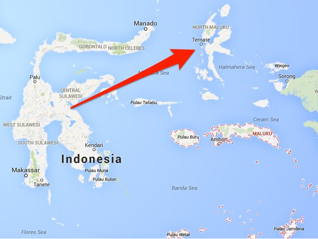
Indonesia: 7.3 quake with potential tsunami

map Moluccas
© www.businessinsider.comSite of 7.3 earthquake near Ternate island, Moluccas.
A major earthquake with a magnitude of 7.3 was recorded off the Moluccas in Indonesia on Saturday, the national disaster mitigation agency said, causing residents near the quake to flee their homes after a tsunami warning was issued.

The earthquake was felt strongly on the Sitaro islands, where authorities also warned people to stay away from beaches and riverbanks, Sutopo Purwo Nugroho, a spokesman at Indonesian agency, said in a statement. There were no reports of casualties or major damage. MetroTV reported power cuts in some parts of Manado, the capital of North Sulawesi province.

"It was strong," said Regina Saerang, an eyewitness in Manado. "I felt it for about a minute. There was no damage but people on my street are pouring out of our houses." The head of the disaster mitigation agency had ordered the preparation of aircraft and logistics in case they were needed and further checks of the affected areas were being made, Nugroho said.
equake bubbles
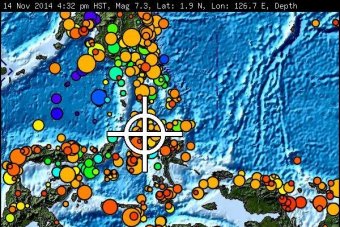
© www.abc.net.auThe earthquake parameters provided by the Pacific Tsunami Warning Center
The Pacific Tsunami Warning Center in Hawaii said hazardous tsunamis were possible within 300 km (185 miles) of the quake's epicenter, although there was no danger of a Pacific-wide tsunami.

It had also warned that tsunamis could be expected to reach Indonesia, the Philippines, Palau, Papua New Guinea, the Solomon Islands and the Marshall Islands, and even as far away as Taiwan and Japan's Okinawa. The first waves could reach land within 30 minutes and the last within about six hours. "The initial wave may not be the largest," the center warned.

Comment: Based on USGS data, earthquake frequency has risen sharply by more than 30% since the 1990s. There is a strong correlation proven between earthquakes and sunspots. An intensification of the magnetic field has implications for Earth's crust, triggering earthquakes. Precursors that indicate alerts of this potential rise also include increases in: low frequency electromagnetic emission, magnetic field anomalies, earthquake lights from ridges and mountain tops, temperature anomalies over wide areas and changes in plasma density of the ionosphere. While we think of rocks as being poor conductors of electricity, there are times when this is the reverse, as when under severe stress from the slowing down of earth rotation, the reduction in gravity that allows for an "opening up" phenomenon that increases the chances for strong earthquakes, and the reshaping of Earth from more ovoid to spherical. The Pacific Rim has proved to be one of the most regions conducive to the rising magnitude levels and frequencies of major earthquakes of late.*

Earth Changes and the Human Cosmic Connection: The Secret History of the World - Book 3


Bizarro Earth

Magnitude 5.6 earthquake strikes Peruvian coast near Lima

5.6 earthquke peru november 15 2014
A 5.6 magnitude earthquake struck the Pacific near the Peruvian coast late on Friday, rocking buildings for several seconds in the capital Lima and disrupting cellphone services briefly.

There were no immediate reports of damages or injuries.

The quake hit 7.45 miles (12 kilometers) southwest of Mala, a coastal town near Lima, at a depth of 28.8 miles (46.4 kilometers), according to the U.S. Geological Survey.

Peru's Geophysical Institute, which measures earthquakes on the Richter scale, initially reported a magnitude of 5.8.

Peru's Navy said on Twitter that the quake did not trigger tsunami alerts.