Earthquakes
S


Palette

Italian earthquakes raise concern over safety of Michelangelo's David

michelangelo david
More than 250 tremors have been rattling Florence and the Chianti region since Friday, raising concerns over the safety of Michelangelo's David.

According to Italy's National Institute of Geophysics and Volcanology, the two major shocks that hit the wine-growing region measured 3.8. and 4.1 on the Richter scale, while several others reached 3.0 to 3.5, scaring people but leaving no one injured.

Minor tremors are continuing at the moment, sparking alarm over the national art treasure, with the focus on Michelangelo's statue of David. Earlier this year, experts found David at risk of crumbling down under its own weight because of tiny fractures in its ankles.

Comment: More than 30 earthquake tremors hit Italy's Chianti region


Bizarro Earth

USGS: Earthquake Magnitude 6.6 - 157km WNW of Tobelo, Indonesia

Tobelo Quake_211214
© USGS
Event Time
2014-12-21 11:34:14 UTC
2014-12-21 19:34:14 UTC+08:00 at epicenter

Location
2.126°N 126.651°E depth=54.6km (34.0mi)

Nearby Cities
157km (98mi) WNW of Tobelo, Indonesia
168km (104mi) NNW of Kota Ternate, Indonesia
168km (104mi) NNW of Ternate, Indonesia
179km (111mi) ENE of Bitung, Indonesia
1042km (647mi) WSW of Koror Town, Palau

Scientific Data

Attention

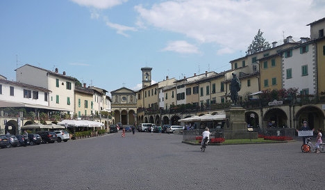
More than 30 earthquake tremors hit Italy's Chianti region

Image
© Konrad LawsonThe epicentre of the strongest quake was nine kilometres below ground close to Greve in Chianti.
Several mini-earthquakes with a maximum magnitude of 4.1 shook Italy's famous Chianti wine region on Friday.

The tremors were sufficiently powerful to result in homes, schools and offices being evacuated but no serious damage or injuries were reported.

The National Institute for Geophysics and Vulcanology (INGV) said there had been more than 30 tremors over 24 hours with the strongest, measuring 3.8 and 4.1, registered mid-morning on Friday.

The epicentre of the strongest quake was nine kilometres (six miles) below ground close to Greve in Chianti, one of the best known wine villages in an area of rolling hills around and between the historic cities of Florence and Siena.

The area lies in the foothills of the central section of the Apennine mountains, which run like a spine down the centre of Italy and are subject to significant seismic activity.

Source: AFP

Bizarro Earth

Magnitude 5.7 strikes the Basse-Terre island in Guadeloupe

basse terre, guadeloupe
A magnitude 5.7 earthquake struck the Basse-Terre island of the France's Guadeloupe archipelago in the Antilles on Friday, the U.S. Geological Survey said.

It said the quake's epicenter was located three miles (4.8 km)northwest of Lamentin on Basse-Terre and was 69.5 miles (111 km)deep. It struck at 3:49 p.m. (1949 GMT)

Bizarro Earth

USGS: Earthquake Magnitude 6.1 - 86km NE of Keelung, Taiwan

Keelung Quake_101214
© USGS
Event Time
2014-12-10 21:03:39 UTC
2014-12-11 05:03:39 UTC+08:00 at epicenter

Location
25.568°N 122.448°E depth=254.4km (158.1mi)

Nearby Cities
86km (53mi) NE of Keelung, Taiwan
108km (67mi) ENE of Taipei, Taiwan
113km (70mi) NE of Yilan, Taiwan
116km (72mi) ENE of Banqiao, Taiwan
918km (570mi) ENE of Hong Kong, Hong Kong

Scientific Data

Bizarro Earth

Magnitude-6.6 tremor is second large quake to rock Panama in 3 Days

Panama Quake_081214
© USGS
A magnitude-6.6 earthquake struck off the coast of Panama on Monday, the second strong quake to rock the country in three days. The tremor was centered 20 kilometers (12 miles) south-southeast of the Punta de Burica peninsula, near the border with Costa Rica, and hit just before 4:00 a.m. local time, according to the U.S. Geological Survey.

Despite the earthquake's magnitude and widespread shaking, the director of Panama's National Civil Defense Service, José Donderis, indicated via Twitter that there were no reports of damage. The epicenter of the quake, which occurred at a depth of 20 kilometers, was about 58 kilometers south-southwest of the city of David, Panama's third-largest city with a population of about 145,000 people. Any aftershocks are expected to be less intense, however, they could be strong enough to cause damage to infrastructure possibly weakened by the main earthquake.

Bizarro Earth

USGS: Earthquake magnitude 6.8 - 116km WSW of Panguna, Papua New Guinea

Panguna Quake_071214
© USGS
Event Time
2014-12-07 01:22:00 UTC
2014-12-07 11:22:00 UTC+10:00 at epicenter

Location
6.537°S 154.455°E depth=10.0km (6.2mi)

Nearby Cities
116km (72mi) WSW of Panguna, Papua New Guinea
124km (77mi) WSW of Arawa, Papua New Guinea
342km (213mi) SE of Kokopo, Papua New Guinea
489km (304mi) ESE of Kimbe, Papua New Guinea
685km (426mi) WNW of Honiara, Solomon Islands

Scientific Data

Bizarro Earth

6.0-magnitude earthquake strikes off Indonesian coast

Saumlaki Quake_061214
© USGS
Moscow - A 6.0-magnitude earthquake struck off Indonesian coast of Yamdena Island, the US Geological Survey reports.

The quakes took place at around 10 p.m. GMT, with the epicenter 222 km (138 miles) to the northwest of Saumlaki town, located on Yamdena island. The quake happened at a depth of 117.3 km (72.9 miles).

No damage or injuries have been reported in the area. Indonesia, which comprises thousands of islands, is vulnerable to earthquakes due to its geographical location.

In 2004, a 9.2-magnitude earthquake hit Indonesia off the coast of Sumatra Island, triggering powerful tsunami waves which killed at least 220,000 people.

Comment: Within only the last few weeks, in just this one location (off the Indonesian coastline), there have been 6.9 and 7.3 magnitude earthquakes! This phenomena is growing in frequency and intensity.

To understand why this is happening, read Earth Changes and the Human-Cosmic Connection. Here's a relevant excerpt:
From 1973 to 1996, earthquake and eruption frequencies were almost stable, increasing only slightly year after year, but from 1996 onwards, an acceleration is noticeable. Volcanic eruptions show an increase from about 59 eruptions per year at the end of the 1990s to roughly 75 eruptions per year in the period 2007 - 2010 (+30%).

Today, the increase in volcanic activity has reached such a level that, by late November 2013, 35 volcanoes were actively erupting , including volcanoes that had been dormant for decades.

It could be argued that the increase in both the frequency and intensity of earthquakes and volcanic eruptions is, at least partly, a result of the slowdown and 'opening up' processes:

1) The Earth's minute slowdown exerts mechanical stress on the crust (compression at low latitudes and extension at high latitude). This stress deforms the crust. This deformation is more pronounced and can even lead to partial ruptures around the weakest spots of the crust, i.e. the fault lines (boundaries between tectonic plates) which are the typical location of seismic and volcanic activity.

2) The mantle has a higher density than the crust and therefore has a higher momentum and won't slow down as fast as the crust. The difference in rotation between the crust and the mantle is equal to the crustal slippage. The fluidity of the mantle enables slippage induced by the different momentum carried by the crust, the upper mantle and the core.

This speed difference can cause friction at the interface between the crust and the mantle. This friction can locally deform the crust and cause earthquakes and eruptions.

3) The decrease in the surface - core E-field reduces the binding force and loosens the tectonic plates relative to each other. The plates are then free to move relative to each other. It is this very relative movement (divergence, convergence or sliding) which is one of the main causes for earthquakes and volcanic eruptions:
[Change] in Earth's speed of rotation would induce changes in the magma tide as it adjusted to the new equator or altered rotational speed. Such changes, however, might not be uniform throughout, owing to a 'drag' factor deep in the magma itself, although, overall, they would certainly impose terrible strains on the lithosphere generally.
4) A final factor involved in earthquakes and volcanic eruptions is electromagnetism:
Some scientists have become aware of a correlation between sunspots and earthquakes and want to use sunspot data to help predict earthquakes. The theory is that an intensification of the magnetic field can cause changes in the geosphere [i.e. crust]. NASA and the European Geosciences Union have already put their stamp of approval on the sunspot hypothesis, which suggests that certain changes in the Sun-Earth environment affect the magnetic field of the Earth, which can then trigger earthquakes in areas prone to them. It is not clear how such a trigger might work.


Bizarro Earth

Strong 6.0-magnitude earthquake shakes Costa Rica and Panama

Panama Quake_061214
© USGSA map of the quake.
A strong 6.0-magnitude earthquake shook Costa Rica and Panama on Saturday morning, according to the United States Geological Survey.

The quake, which occurred at a depth of 36 kilometres, struck around 18 kilometres east of Punta de Burica in Panama, about 258 kilometres southeast of San Jose, Costa Rica.

The quake caused reports of shaking across both countries, with reports of "strong" shaking toward the border region between the two Central American neighbours. The shaking extended to both the Caribbean and Pacific coasts of the countries.

The quake came a week after a 5.1-magnitude quake shook the border region between Panama and Colombia.

The extent of any damage or injuries was not yet clear.

Bizarro Earth

Northwest Montana rattled by two more earthquakes felt in McGregor Lake area

Image
© jimbosjourneys.comMcGregor Lake
Just three weeks after a pair of rare earthquakes rattled windows and bookshelves, two more seismic events were reported in the Flathead Valley and scientists say this could be an indication that a seismic "swarm" has begun in the area.

On Dec. 1 at 5:40 a.m., a 3.0 magnitude earthquake shook the McGregor Lake area, almost the exact same area impacted by the 4.0 quake on Nov. 11. The epicenter of the earthquake was 3.6 miles beneath the surface. Less than three hours later at 8:13 a.m., a 3.5 magnitude earthquake 5.3 miles below the surface shook the same exact area.

Mike Stickney, director of the Montana Bureau of Mines and Geology's Earthquake Studies Office, said there were a number of reports from local residents who said they felt the second quake.

Earthquakes are rare but not unheard of in Northwest Montana and Stickney said the series of shakes could indicate that a seismic "swarm" is beginning.

Comment: 4.7 magnitude earthquake strikes near Sedona, Arizona