Earthquakes
S


Attention

Unprecedented earthquake in Playa del Carmen and Tulum, Mexico - areas not known for seismic acivity

Yucatan Earthquake Seismograph
An earthquake was registered on the evening of Sunday January 10th, with an epicenter near Playa del Carmen, Quintana Roo, an area traditionally considered non seismic. According to Margarita Vidal Amaro of the National Seismological Service, an earthquake of magnitude 4.2 on the Richter scale occurred at 9:49 pm on Sunday January 10th 2015. The epicenter was located exactly 67 kilometers (41 miles) southwest of Playa del Carmen, in Quintana Roo.

Several Twitter users such as @FerDelor, @arnulfo_26, @CarlosQuikeYam and @linachapa among others, posted comments regarding this unusual event in this part of the country.

The government of Quintana Roo requested support from national institutions on Monday January 12th, to help determine the causes of this earthquake that occurred off the coast of Tulum. But the National Seismological Service in Mexico City officially confirmed the event since Sunday January 11th. Vidal Amaro explained that the quake occurred on the mainland and so there was no danger of a tsunami in the area. She added that even though earthquakes are unprecedented in the area, there are tectonic plates all over Mexico, which can lead to earthquakes. The quake was felt with greater magnitude in the town of Tulum, according to reports on social networks.

Source

Comment: And if it's not tectonic plates, then WHAT is causing the increase in earthquakes or ones deemed "unprecedented"?

Also see:


Bizarro Earth

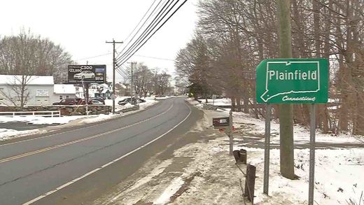
Earthquake in eastern Connecticut is 4th straight day of quakes in area

Image
A 2.2-magnitude earthquake has rattled eastern Connecticut again.

In what's becoming a daily seismic event, the Weston Observatory of Boston College said the earthquake occurred at about 4:40 a.m. Thursday near Plainfield, where previous earthquakes were recorded.

It says two minor earthquakes were recorded on Wednesday and another on Tuesday.

Several were recorded on Monday and last week, too.

The observatory says that while the greatest earthquake activity in the United States is in the west, earthquakes are "quite common" in many areas of the eastern United States, including New England.

Plainfield officials have invited Alan Kafka, director of the observatory, to an informational meeting at 6:30 p.m. Friday at the town's high school.

Comment: While this earthquake activity is being described as "quite common", it certainly seems as though something strange is going on in Connecticut for all this earthquake activity to be happening.


Bizarro Earth

Loud explosion precedes series of earthquakes in New England

Image
© WFSBThe Weston Observatory recorded four small earthquakes in the Plainfield area on Monday morning.
Five small earthquakes rattled New England on Monday.

It was the third day in less than a week that rumbles shook the Plainfield region.

Plainfield police said they received dozens of calls about homes shaking in the Plainfield, Killingly, Brooklyn and Sterling areas. They received even more around the noon hour.

"They just started pouring in regarding a loud explosion," said Capt. Mario Arriaga, with the Plainfield Police Department. "However, this time, people were reporting earthquakes since last time we had one on the 12th."

Authorities released a few of the 911 calls they received. Police said they received well over 100 calls.

"We just had a massive earthquake again," one caller reported.

"It sounded like a bomb and everything was shaking," another caller said.

Comment: Loud booms and explosion-like sounds are more and more frequently associated with earthquakes these days. There is also the possibility that some earthquakes could have been caused by meteorites breaking up in the atmosphere in New England. However, you are unlikely to hear this from the mainstream media.

Breaking: Meteor outburst over 6 Northeastern U.S. states - Connecticut, New York, New Hampshire, New Jersey, Massachusetts and Maine (so far...)


Bizarro Earth

Indonesia's Soputan volcano blows its top in strong, explosive eruption

Image
The volcano erupted this morning at 02:45 local time with a strong explosion from the summit lava dome. It sent an 6 km tall ash column to approx. 26,000 ft (8,5 km) altitude. The eruption followed an increase in seismic activity in December, when so-called "drumbeat" earthquakes appeared - a type of volcanic tremor typically associated with movements of viscous magma at shallow depths,- in this case new lava rising beneath the existing lava dome (in place since 1991). As a consequence, the alert status of the volcano had been raised to the second highest level "Siaga" (3 on a scale of 1-4, alert).

Today's explosion caused parts of the summit dome that occupies the crater, open to the western flank, to collapse and produce a glowing avalanche that traveled approx. 2000 m, remaining within the volcano's caldera. It seems that no pyroclastic flow (which could sweep over the caldera walls and into inhabited areas below) occurred. No damage to people or infrastructure was reported. Continued glow from the summit dome after the explosion suggests that magma has and continues to arrive now there. - Volcano Discovery

Comment: Time-bomb? Iceland's Bardarbunga volcano eruption mystery - ground sinking below lava build-up by a foot a day


Bizarro Earth

Time-bomb? Iceland's Bardarbunga volcano eruption mystery - ground sinking below lava build-up by a foot a day

Image
Skaftafell - Just north of here, on the far side of the impenetrable Vatnajokull ice sheet, lava is spewing from a crack in the earth on the flanks of Bardarbunga, one of Iceland's largest volcanoes. By volcanologists' standards, it is a peaceful eruption, the lava merely spreading across the landscape as gases bubble out of it. For now, those gases - especially sulfur dioxide, which can cause respiratory and other problems - are the main concern, prompting health advisories in the capital, Reykjavik, 150 miles to the west, and elsewhere around the country.

But sometime soon, the top of Bardarbunga, which lies under as much as half a mile of ice, may erupt explosively. That could send plumes of gritty ash into the sky that could shut down air travel across Europe because of the damage the ash can do to jet engines. And it could unleash a torrent of glacial meltwater that could wipe out the only road connecting southern Iceland to the capital. All of that could happen. Then again, it may not.

Such are the mysteries of volcanoes that more than four months after Bardarbunga began erupting, scientists here are still debating what will happen next. The truth is, no one really knows. Volcanic eruptions are among the Earth's most cataclysmic events, and understanding how and when they happen can be crucial to saving lives and reducing damage to infrastructure and other property.

Comment: Indonesia's Soputan volcano blows its top in strong, explosive eruption


Bizarro Earth

Texas trembling! Swarm of nine earthquakes rattle the State in one day

Image
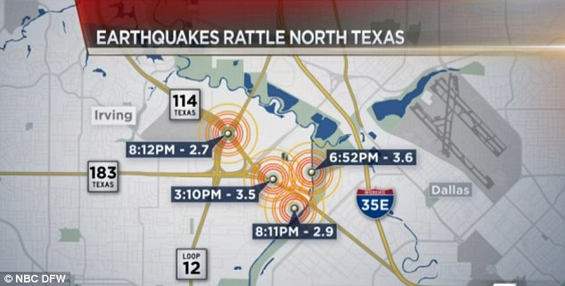
© NBC DFWMap: The U.S. Geological Service plotted the epicenters of the first four quakes to northeast Irving, a Dallas suburb in North Texas
Nine small earthquakes rattled North Texas just hours apart on Tuesday, though no damage has so far been reported from the temblors.

The magnitudes of the earthquakes, which began around 7.30am, ranged from 1.6 to 3.6, according to the USGS. Earthquakes of magnitude 2.5 to 3.0 are generally the smallest people can feel.

The U.S. Geological Service plotted the epicenters of the first four quakes to northeast Irving, a Dallas suburb. At least two of those could be felt throughout the Dallas-Fort Worth area.

Seismologists also installed a new earthquake-monitoring device in Irving this week, after minor temblors rocked an area which is near the site of the former Dallas Cowboys football stadium.

The first quake at 3:10 p.m. measured 3.5 in magnitude. Another at about 7 p.m. measured 3.6, while tremors at 8:11 p.m. and 8:12 p.m. measured less than 3.0.

The first four happened within an area near the Trinity River that's seen a swarm of mild temblors in recent months.

USGS geophysicist Jana Pursley says Tuesday's quakes were the 'largest since the earthquakes started happening there in the last year.'

According to NBC DFW, a 1.7 earthquake took place close to a Dallas intersection at 9:54pm, and a 2.4 earthquake hit Irving's University of Dallas campus at 10:05pm.

A 1.6 earthquake struck at 11:02pm - and like many of the other quakes, was also in the vicinity of the Trinity River, the affiliate station reported.

Comment: These earthquake swarms are intensifying! As well as the increasing evidence linking fracking to increased seismic activity, the Earth is 'opening up' as seismologists confirm a global surge of great earthquakes from 2004-2014 and the earthquake frequency increasing rate of strong quakes doubles in 2014

To understand why this is happening, read Earth Changes and the Human-Cosmic Connection. Here's a relevant excerpt:
From 1973 to 1996, earthquake and eruption frequencies were almost stable, increasing only slightly year after year, but from 1996 onwards, an acceleration is noticeable. Volcanic eruptions show an increase from about 59 eruptions per year at the end of the 1990s to roughly 75 eruptions per year in the period 2007 - 2010 (+30%).

Today, the increase in volcanic activity has reached such a level that, by late November 2013, 35 volcanoes were actively erupting , including volcanoes that had been dormant for decades.

It could be argued that the increase in both the frequency and intensity of earthquakes and volcanic eruptions is, at least partly, a result of the slowdown and 'opening up' processes:

1) The Earth's minute slowdown exerts mechanical stress on the crust (compression at low latitudes and extension at high latitude). This stress deforms the crust. This deformation is more pronounced and can even lead to partial ruptures around the weakest spots of the crust, i.e. the fault lines (boundaries between tectonic plates) which are the typical location of seismic and volcanic activity.

2) The mantle has a higher density than the crust and therefore has a higher momentum and won't slow down as fast as the crust. The difference in rotation between the crust and the mantle is equal to the crustal slippage. The fluidity of the mantle enables slippage induced by the different momentum carried by the crust, the upper mantle and the core.

This speed difference can cause friction at the interface between the crust and the mantle. This friction can locally deform the crust and cause earthquakes and eruptions.

3) The decrease in the surface - core E-field reduces the binding force and loosens the tectonic plates relative to each other. The plates are then free to move relative to each other. It is this very relative movement (divergence, convergence or sliding) which is one of the main causes for earthquakes and volcanic eruptions:
[Change] in Earth's speed of rotation would induce changes in the magma tide as it adjusted to the new equator or altered rotational speed. Such changes, however, might not be uniform throughout, owing to a 'drag' factor deep in the magma itself, although, overall, they would certainly impose terrible strains on the lithosphere generally.
4) A final factor involved in earthquakes and volcanic eruptions is electromagnetism:
Some scientists have become aware of a correlation between sunspots and earthquakes and want to use sunspot data to help predict earthquakes. The theory is that an intensification of the magnetic field can cause changes in the geosphere [i.e. crust]. NASA and the European Geosciences Union have already put their stamp of approval on the sunspot hypothesis, which suggests that certain changes in the Sun-Earth environment affect the magnetic field of the Earth, which can then trigger earthquakes in areas prone to them. It is not clear how such a trigger might work.

Bizarro Earth

Magnitude-6.6 earthquake strikes off Pacific coast of Panama

Image
© Associated Press
The U.S. Geological Survey says a magnitude-6.6 earthquake has struck off the Pacific coast of Panama. There are no immediate reports of injuries or damage.

The U.S.G.S. said the quake hit at 11:07 p.m. local time Tuesday with its epicenter 151 miles (245 kilometers) south of the coastal city of Punta de Burica, close to the border with Costa Rica. Its depth was measured at 20 miles (33 kilometers).

The Pacific Tsunami Warning Center says no tsunami threat was issued for the area following the quake.

In early December, two earthquakes with magnitudes of 5.8 and 6.6 struck in the same region without causing damage or injuries.

Alarm Clock

Spate of strong earthquakes rattles NZ's South Island

Methven earthquakes hits New Zealand
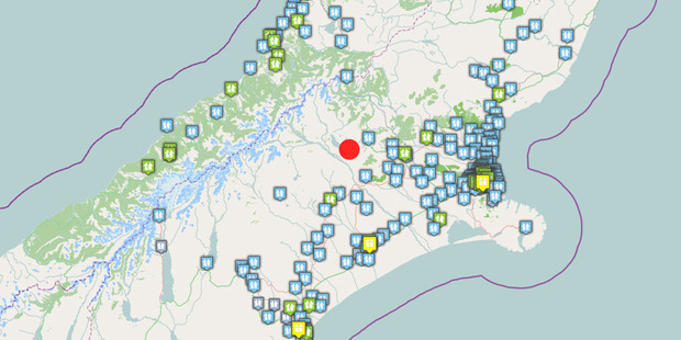
© GNS ScienceThis GNS map shows the location of the 6.4 magnitude quake in red, with some of the first 'felt reports' it received from around the region.
A spate of strong earthquakes have struck the central South Island this morning.

Four quakes measuring between 6.4 and 4.1 in magnitude hit the Methven and Arthur's Pass area between 6.48am and 6.59am.

The first tremor, measuring 6.4, struck 35km north of Methven at 6.48am, GNS Science reported.

Did you feel it? Do you have photos or video to share? Email us here.

The tremor, which was 11km deep, was classified as severe.

A southern police communications spokesman said they had not received any reports of damage.

Four minutes later at 6.52am, a second quake measuring 4.1 in magnitude rocked the region.

It was centred 30km west of Arthur's Pass and was 5km deep.

GNS classified the quake as strong.

At 6.58 a third quake, measuring 4.1 hit the same spot, GNS said.
It was 5km deep.

Then, a minute later at 6.59am, another strong quake hit the same location, measuring 4.2 in magnitude. It was also shallow, centred 5km deep.

Comment: USGS has the first earthquake as being 5.6. One wonders why USGS often has the same earthquakes recorded as being of lower magnitude than other more local geological surveys.


Attention

5.1M earthquake hits off coast of Northern California

Image
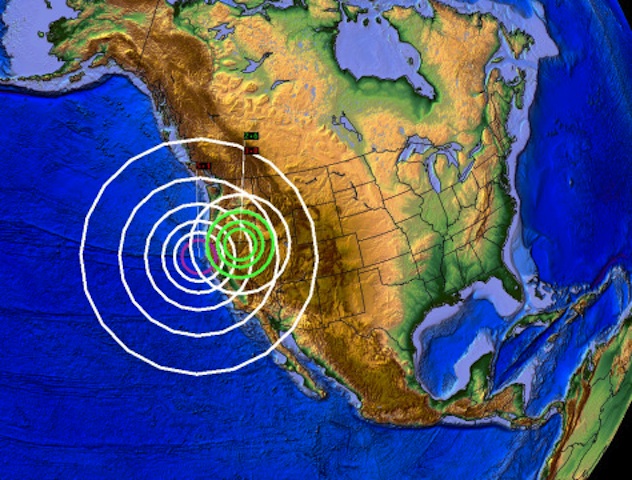
© DutchsinseJanuary 1, 2015: 5.1M earthquake off the shores of California, and new swarm develops at the border of Nevada and Oregon.
A noteworthy 5.1 magnitude earthquake has struck off the shores of Northwest California.

2 days ago, on December 30 2014, I made a post on a earthquake which occurred just South of Los Angeles California - happening near a few offshore drilling platforms.

In the website post from December 30th, I made note of the event, an said we need to watch the area for larger movement (based upon the activity showing near LA / oil platforms).

Quote my forecast from 2 days prior:
"Overall, we can expect the movement to continue in the region, especially due to the movement occurring along the edge of the Craton, as well as the excessive movement happening around the Pacific plate.

Indeed it is not just the fracking / drilling operations we need to be watching, but also the dormant volcanoes (salton sea, mono lake, clear lake, mammoth mountain etc..) for movement in the near term."
Now that a 5.1M earthquake has struck near the coast of NW California, this confirms the pressure rebuilding on the West coast causes activity at known volcanic sites.

This 5.1M event happening very close to the fresh lavic fields formed off the coast of Oregon.

Lava fields off Oregon story in the MSM here and here.

Bizarro Earth

USGS: Earthquake Magnitude 6.1 - 12km SSE of Cagayancillo, Philippines

Philippines Quake_291214
© USGS
Event Time
2014-12-29 09:29:41 UTC
2014-12-29 17:29:41 UTC+08:00 at epicenter

Location
8.602°N 121.504°E depth=37.9km (23.5mi)

Nearby Cities
112km (70mi) SSE of Cagayancillo, Philippines
143km (89mi) NW of Titay, Philippines
149km (93mi) NW of Ipil, Philippines
152km (94mi) SW of Asia, Philippines
666km (414mi) S of Manila, Philippines

Scientific Data