Earthquakes
S


Bizarro Earth

Magnitude 5.0 earthquake jolts Catanduane, Philippines

Image
The Provincial Disaster Risk Reduction and Management Council (PDRRMC) has yet to receive a report regarding possible damage from the magnitude 5.0 earthquake that shook Catanduanes 12:16 a.m. Saturday. PDRRMC in-charge Jerry Beo told the Philippine Daily Inquirer that he has yet to establish communications with local officials in Gigmoto town where the epicenter was located.

The United States Geological Survey (USGS) calculated the epicenter of the quake to be in the vicinity of Barangay (village) Dororian at 13.719 degree north and 124.384 degree east, or around six kilometers south of Gigmoto proper. The island province of Catanduanes is just 200 kilometers west of the Philippine Trench, which has generated large earthquakes in the past.

In the capital town of Virac, many people were roused from their sleep by the earthquake, which they say was preceded by a humming sound. According to subdivision residents Guillermo Castilla and Leo Austero, the shaking was strong enough for them to hear creaking and groaning sounds coming from their houses.

The USGS said earthquakes of this magnitude usually have aftershocks, with the secondary shock waves usually less violent but could be strong enough to do additional damage to weakened structures and may occur in the first hours, days, weeks or even months after the quake.

Bizarro Earth

Update - Mammoth Lakes earthquakes now exceed 1059 in latest seismic swarm

Image
The Long Valley Caldera is experiencing a large seismic swarm. As magma moves through the earth, it displaces and fractures rock along the way. This movement causes earthquakes that can be recorded with seismometers at the surface of the earth. Seismic monitoring is the most used technique for volcano surveillance. Volcanic earthquakes often provide the initial sign of volcanic unrest. Their signals differ from typical, tectonic, earthquakes because they tend to be found at depths shallower than 10 km, are small in magnitude (< 3), occur in swarms, and are restricted to the area beneath a volcano. Harmonic tremor, or volcanic tremor, is the name for the continuous, rhythmic seismic energy associated with underground magma movement. At Long Valley Caldera, there are currently 61 seismometers that make up the seismic network used to determine earthquake location and energy of movement with time.
Image
The first instrument was installed in 1974 and additional instruments were added throughout the 1980s and 1990s. Between 2000 and 2003, the seismic network was updated to include additional, more modern instruments. More than 200 more earthquakes have erupted in the area in a 24 hour period. Additionally, some earthquakes were now reported at shallower depths. Rodger Wilson, who is following this area for tens of years, hasn't seen this activity since the 1990′s! We have the impression however that the frequency of the earthquakes has seriously declined the last couple of hours. The seismicity at Mammoth Lakes California has even increased compared to this morning. Below all earthquake epicenters during the last 24 hours. Depth of the hypocenters still at +10 km. Earthquake swarms are a regular phenomenon at Long Valley but nobody knows where the magma will move next. We will have to wait and see if this latest swarm indicates a massive movement of magma and might be an early-warning sign that Long Valley might be moving towards an eruption. The last eruption at the volcano is said to have occurred 700,000 years ago and is long over-due. - ER, USGS, TEP

Comment: Nearly 3 dozen small quakes in 24 hours - Volcanic unrest at Mammoth Lakes?


Bizarro Earth

Nearly 3 dozen small quakes in 24 hours - Volcanic unrest at Mammoth Lakes?

Image
© Wally Skalij / Los Angeles TimesIn this 2012 photo, runners take to a trail in the Mammoth Lakes region in California's Eastern Sierra.
Nearly three dozen earthquakes have rattled the Mammoth Lakes region in less than 24 hours as the area continues to experience ripple effects of "volcanic unrest," according to the U.S. Geological Survey. The temblors -- all between magnitude 2.5 and 3.8 -- have struck since 9 a.m. Thursday, with the latest recorded at 1:49 a.m. Friday, according to the USGS. The 3.8-quake occurred at 9:21 p.m. with an epicenter six miles from Mammoth Lakes.

Heightened earthquake and ground uplift activity have been measured at Mammoth Mountain and the Long Valley Caldera over the last few decades. At 11,053 feet, Mammoth Mountain in California's Eastern Sierra is a lava dome complex on the southwest rim of Long Valley Caldera, although eruptions haven't occurred for some 57,000 years. The recent swarm of quakes in and around the mountain is being tied to recent "volcanic unrest" marked by gas emissions, tree die-offs and intrusions of upward-moving sheets of rock, according to the USGS.

USGS data for recent quakes

Bizarro Earth

USGS: Earthquake Magnitude 6.2 - 95km WNW of Willow, Alaska

Alaska Quake_250914
© USGS
Event Time
2014-09-25 17:51:17 UTC
2014-09-25 09:51:17 UTC-08:00 at epicenter
Location
61.965°N 151.794°W depth=101.7km (63.2mi)

Nearby Cities
95km (59mi) WNW of Willow, Alaska
126km (78mi) WNW of Knik-Fairview, Alaska
130km (81mi) NW of Anchorage, Alaska
378km (235mi) SSW of College, Alaska
904km (562mi) WNW of Whitehorse, Canada

Scientific Data

Attention

Fukushima, Japan rocked by two earthquakes in one hour; epicenter near nuclear plants

Image
A pair of moderate earthquakes struck just off the coast of Japan's Fukushima Prefecture Wednesday, close to the nuclear power plants crippled by the March 2011 tsunami. There were no early reports of damage, injuries, or new problems at the nuclear plants. The Japan Meteorological Agency says the first earthquake struck at 9:45 p.m. JST (8:45 a.m. EDT in the U.S.) and registered a magnitude of 5.0. The second quake, a slightly stronger magnitude-5.2 tremor, struck 46 minutes later. Both were centered just off the coast of Fukushima Prefecture, where the Fukushima Daiichi and Fukushimi Daini reactors were severely damaged in the March 11, 2011 tsunami that followed a magnitude-9.0 quake farther offshore.

The damage spawned the worst crisis at a nuclear power plant since the Chernobyl disaster in 1986, and prompted Japan to shut down most of its nuclear power plants. Tokyo Electric Power Company (TEPCO) has been working to contain radioactive materials in the years since. TEPCO said there were no new abnormalities caused by Wednesday's quakes, nor any changes to radioactivity levels at the monitoring post there, according to public broadcaster NHK. The company said there were no reported abnormalities at its Tokai Daini nuclear power plant, farther south along the coast of Ibaraki Prefecture. The plant has been shut down since 2011.

Comment: There has been a lot of seismic activity lately. See the following Sott Worldview map of recorded earthquakes in the past month alone:


Bizarro Earth

USGS: Earthquake Magnitude 6.0 - 160km SSW of Gizo, Solomon Islands

Solomon Island Quake_250914
© USGS
Event Time
2014-09-25 09:13:50 UTC
2014-09-25 19:13:50 UTC+10:00 at epicenter

Location
9.480°S 156.391°E depth=10.0km (6.2mi)

Nearby Cities
160km (99mi) SSW of Gizo, Solomon Islands
373km (232mi) SSE of Arawa, Papua New Guinea
390km (242mi) W of Honiara, Solomon Islands
661km (411mi) E of Alotau, Papua New Guinea
727km (452mi) SE of Kokopo, Papua New Guinea

Scientific Data

Alarm Clock

USGS: Earthquake Magnitude 6.2 - 46km NNW of San Antonio de los Cobres, Argentina

Earthquake 6.2 Argentina
© USGS
Event Time
014-09-24 11:16:12 UTC
2014-09-24 08:16:12 UTC-03:00 at epicenter

Location
23.854°S 66.553°W depth=189.3km (117.6mi)

Nearby Cities
46km (29mi) NNW of San Antonio de los Cobres, Argentina
133km (83mi) WNW of San Salvador de Jujuy, Argentina
142km (88mi) WSW of Humahuaca, Argentina
143km (89mi) WNW of Palpala, Argentina
831km (516mi) SSE of La Paz, Bolivia

Scientific data

Attention

Sweden earthquake 'was strongest in 100 years'

Sweden earthquake
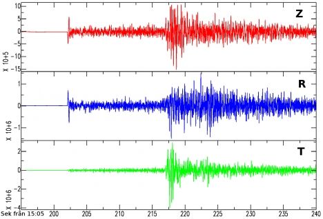
© TTThis graph shows the moment of impact in Hassela, which is 13 kilometres from the earthquake's epicentre.
An earthquake measuring 4.1 on the Richter scale shook parts of central Sweden on Monday and experts have revealed it was the strongest in a century.

The quake hit in the afternoon between the towns of Mora and Sveg.

"There was a bloody great bang, it was like a bomb," Åke Hedman near Ljusdal told the Aftonbladet newspaper. "It was as if there was a lightning bolt directly above me - only ten times worse," the 57-year-old added.

Björn Lund, a seismologist at Uppsala University, said the earthquake is the strongest Sweden has seen since 1904 when an area by the Koster islands was hit by an earthquake measuring 5.5 on the scale.

Map

No damage, no tsunami after 7.1 Guam earthquake

guam earthquake
An earthquake struck today just off the island of Guam.

The earthquake, which hit at about 4:30 p.m. ChST, was measured at 7.1 magnitude by the U.S. Geological Survey.

It hit about 21 miles northwest of Piti village, 22 miles northwest of Hagatna, 24 miles northwest of Tamuning-Turnon-Harmon Village, 25 miles west-northwest of Dededo Village, and 26 miles northwest of Mangilao Village.

It hit at a depth of 106.9 miles.

The Pacific Tsunami Warning Center, which is run by the National Weather Center, issued an alert right after the quake hit. "A destructive tsunami was not generated because this earthquake is located too deep inside the earth," it said.

On the other hand, the U.S. Geological Survey said that people should expect aftershocks. "These secondary shockwaves are usually less violent than the main quake but can be strong enough to do additional damage to weakened structures and can occur in the first hours, days, weeks, or even months after the quake," it said.

Bell

USGS: Earthquake Magnitude 7.1 - 44km NW of Piti Village, Guam

Earthquake 7.1 Guam
© USGS
Event Time
2014-09-17 06:14:46 UTC
2014-09-17 16:14:46 UTC+10:00 at epicenter

Location
13.740°N 144.394°E depth=133.9km (83.2mi)

Nearby Cities
44km (27mi) NW of Piti Village, Guam
50km (31mi) NW of Tamuning-Tumon-Harmon Village, Guam
54km (34mi) WNW of Dededo Village, Guam
54km (34mi) NW of Mangilao Village, Guam
48km (30mi) NW of Hagatna, Guam

Scientific data