Earthquakes
S


Bell

USGS: Earthquake Magnitude 7.1 - 44km NW of Piti Village, Guam

Earthquake 7.1 Guam
© USGS
Event Time
2014-09-17 06:14:46 UTC
2014-09-17 16:14:46 UTC+10:00 at epicenter

Location
13.740°N 144.394°E depth=133.9km (83.2mi)

Nearby Cities
44km (27mi) NW of Piti Village, Guam
50km (31mi) NW of Tamuning-Tumon-Harmon Village, Guam
54km (34mi) WNW of Dededo Village, Guam
54km (34mi) NW of Mangilao Village, Guam
48km (30mi) NW of Hagatna, Guam

Scientific data

Bizarro Earth

More big 'Ring of Fire' quakes likely, say scientists

Earthquakes
© xiefei/istockphotoThe findings are based on a new earthquake risk assessment method.
The Pacific Ocean's volcanic 'Ring of Fire' could produce more earthquakes of magnitude 9 or greater, say researchers.

Their findings, reported in the Bulletin of the Seismological Society of America, are based on a new way of calculating the probability of an earthquake.

The new research comes in the wake of the 2004 magnitude 9.3 Sumatra-Andaman earthquake which killed over 230,000 people across the Indian Ocean, and the 2011 magnitude 9 Tohoku earthquake which devastated Japan, claiming almost 19,000 lives.

"The strength of both these earthquakes caught many scientists by surprise," says the study's lead author Dr Yufang Rong, a seismologist with insurer FM Global.

"Almost all past methodologies failed to predict the strength of these earthquakes, so we looked at the problem again."

Existing methods of assessing earthquake risk are based on calculating how often earthquakes of a given magnitude happen along a particular fault line.

All these models are however tied to the limited histories available through earthquake records.
Bizarro Earth

It's not just the magma that could be a problem if Iceland's rumbling Bardarbunga erupts

The red-hot fountains of molten lava, glowing like wildfire, are nothing short of spectacular. Yet they could be ominous portents of things to come. For the second time in four nail-biting years, seismologists in the land of fire and ice, Iceland, are bracing for a monumental volcanic eruption that, once again, threatens to disrupt European air traffic.


Back in 2010, the Eyjafjallajokull volcano, which melted through 200 metres of glacier, sent more than 200 million cubic metres of fine ash billowing almost 10 kilometres into the sky. As a result, several European countries were forced to ground or re-route thousands of flights for several days.
Image

Bizarro Earth

A big chunk of the Sierra Nevada caught fracturing on video

Rock Fracturing
© Screen Capture Youtube
If you like geology, you're used to relying on an active imagination. Most geologic processes occur too slowly to see them play out for yourself. Many of the exceptions are dangerous enough that you might not want a front row seat or are rare enough that the odds of being there to witness them are disheartening. Sometimes, though, the Earth throws us a bone - or in this case, a gigantic slab of granite.

One interesting way that rocks weather and crumble apart is called "exfoliation." Like the skin-scrubbing technique, this involves the outermost layers of exposed igneous or metamorphic bedrock sloughing off in a sheet. Over time, this tends to smooth and round the outcrop - Yosemite's Half Dome providing a spectacular example.

Bizarro Earth

Hidden Napa earthquake faults found by NASA radar

Napa Fault Lines
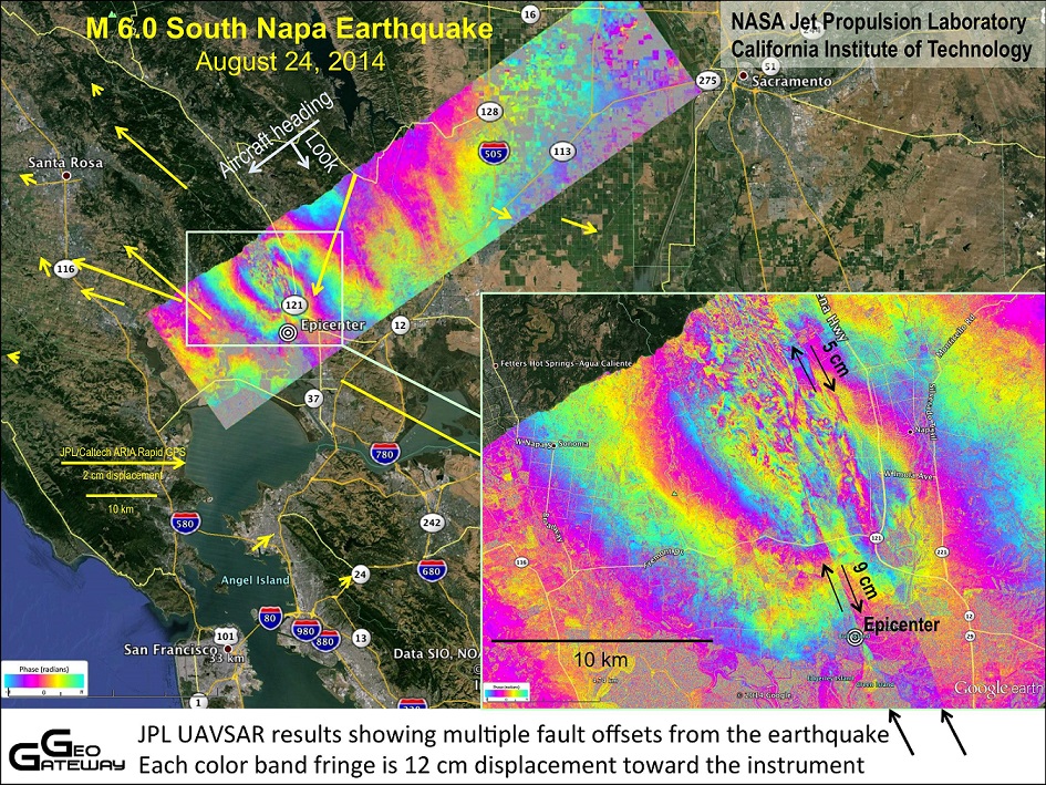
© NASA/JPL-Caltech/ASI/Google EarthGround deformation from the Aug. 24 earthquake in Napa, California. Each color fringe corresponds to deformation of 4.7 inches (12 centimeters).
The Aug. 24 Napa earthquake woke several small, previously unrecognized Napa Valley faults, according to the first results from a high-flying NASA radar instrument.

The magnitude-6.0 Napa earthquake, the biggest to shake northern California in 25 years, injured 170 people and killed one woman, who died from brain bleeding caused by a falling television. Some 800 homes were damaged, and 103 have been deemed too dangerous to enter.

Most of the damage was centered on the West Napa Fault. The U.S. Geological Survey (USGS) found that the West Napa Fault moved a total of 18 inches (46 centimeters) along a 9.3-mile-long (15 kilometers) length, USGS scientist Dan Ponti said Sept. 4 at a USGS earthquake seminar.

Bizarro Earth

USGS: Earthquake Magnitude 6.2 - 122km SE of Modayag, Indonesia

Modayag Quake_100914
© USGS
Event Time
2014-09-10 02:46:06 UTC
2014-09-10 10:46:06 UTC+08:00 at epicenter

Location
0.143°S 125.092°E depth=20.5km (12.8mi)

Nearby Cities
122km (76mi) SE of Modayag, Indonesia
161km (100mi) S of Tondano, Indonesia
165km (103mi) S of Tomohon, Indonesia
175km (109mi) S of Bitung, Indonesia
932km (579mi) N of Dili, East Timor

Scientific Data

Attention

Napa earthquake's bizarre side effect: Creeks flowing again as groundwater rises

Wild Horse Creek
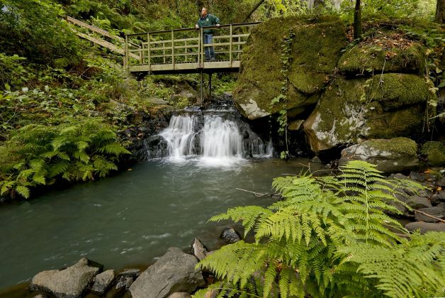
© Michael Macor, The ChronicleWild Horse Creek which flows through Green Valley in Fairfield, Calif., suddenly flowing with water after the August 24, 2014 Napa earthquake.
When the ground stopped shaking after a 6.0-magnitude earthquake last month in Napa, California, something really surprising happened next.

Local residents noticed that some creeks, which had previously run dry due to the state's prolonged drought, were filled with water again.

The strange phenomenon occurred in Solano County's Green Valley, according to SFGate.com, and it's believed it was caused by groundwater that was forced up to the surface when the Earth jolted.

At first, water running through the drought area may seem like a good thing, but that may not be the case this time.

Alarm Clock

USGS: Earthquake Magnitude 6.1 - Easter Island region

Earthquake 6.1 Easter Islands
© USGS
Event Time
2014-09-06 06:53:13 UTC
2014-09-05 22:53:13 UTC-08:00 at epicenter

Location

26.625°S 114.456°W depth=10.0km (6.2mi)

Nearby Cities
502km (312mi) W of Hanga Roa, Chile
3736km (2321mi) ESE of Papao, French Polynesia
3740km (2324mi) ESE of Mahina, French Polynesia
3742km (2325mi) ESE of Paea, French Polynesia
1576km (979mi) E of Adamstown, Pitcairn

Scientific data

Attention

At least 10 volcanic quakes recorded at Taal, Mayon

Image
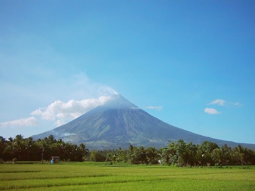
© UnknownClassified as a stratovolcano (a volcano made up of layers of lava alternating with cinder and ash) Mount Mayon or Mayon Volcano is very much active and is located in the in the Bicol Region, in the province of Albay, on Luzon Island, Philippines.
At least 10 volcanic quakes were recorded at two restive volcanoes in Luzon - Taal Volcano in Batangas and Mayon Volcano in Albay - over the last 24 hours, the National Disaster Risk Reduction and Management council said Monday.

Citing data from the Philippine Institute of Volcanology and Seismology, the NDRRMC said seven volcanic quakes were recorded at Taal, and three at Mayon.

While the NDRRMC said there was no sign yet of an imminent eruption, it reminded residents near the two volcanoes to stay away from the permanent danger zones.

The NDRRMC said Alert Level 1 remained at Taal as of 8 a.m. It reminded the public to stay away from the main crater due to the danger of sudden steam explosions and high concentrations of toxic gases.

Bizarro Earth

USGS: Earthquake Magnitude 6.0 - 175km E of 'Ohonua, Tonga

Tonga Quake_040914
© USGS
Event Time
2014-09-04 05:33:46 UTC
2014-09-03 17:33:46 UTC-12:00 at epicenter

Location
21.396°S 173.258°W depth=11.8km (7.4mi)

Nearby Cities
175km (109mi) E of 'Ohonua, Tonga
203km (126mi) E of Nuku'alofa, Tonga
826km (513mi) SSW of Tafuna, American Samoa
833km (518mi) SSW of Pago Pago, American Samoa
851km (529mi) S of Apia, Samoa

Scientific Data