Floods
S

Attention

Millions of gallons of untreated effluent dumping into Puget Sound after heavy rainfall

Puget Sound wastewater pollution
© Emily Eng / The Seattle Times
Millions of gallons of untreated wastewater and stormwater began dumping into Puget Sound Thursday after high tides and heavy rains overwhelmed a King County wastewater-treatment center in Seattle.

Flooding at West Point Treatment Plant in Magnolia's Discovery Park caused damage that apparently fried an electrical circuit and triggered a system shutdown, a spokesman said.

That has caused the county to operate the facility much of Thursday in "emergency bypass mode" โ€” dumping untreated effluent directly into Puget Sound.

Officials were still calculating how much untreated wastewater had flowed into Puget Sound. Doug Williams, a spokesman for the county's Department of Natural Resources and Parks, estimated more than 150 million to 200โ€‰million gallons, with that number likely to grow.

By Thursday night, Williams said the plant was partially back on line and was providing initial treatment to some of the water which had been flowing untreated into the Sound or diverted to other treatment plants.

The dumped sewage is a mix of about 90 percent stormwater and 10 percent wastewater, he said.

The county has managed to divert nearly 200 million gallons of sewage water headed for West Point to four other treatment facilities, Williams said.

Chris Wilke, executive director of Puget Soundkeeper, an environmental watchdog group, said the amount of untreated sewage dumped so far comprises about one-fifth of the typical overflow amount for the area's sewers annually.

Attention

California's Anderson reservoir is so full it's seismically unsafe

Anderson Dam
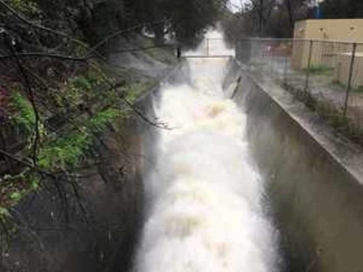
© Michael MooreThe outlet pipe at the bottom of Anderson Dam, pictured Feb. 9, has been wide open since early January.
South Bay water officials are urgently trying to lower a reservoir to reduce pressure on a shaky dam.

The Anderson Reservoir in Morgan Hill is just a couple of miles east of U.S. Highway 101.

The dam is especially vulnerable right now if an earthquake happens to strike.

Water gushes from the bottom of the Anderson Dam. The release valve is wide open and crowds are coming to see what looks like a water show.

Sean Barragan, of Morgan Hill, said, "It's pretty awesome. It's not a thing you see every day."

But it's not just for show.

The water district is trying to quickly lower the level of the reservoir, because it's not seismically safe to be as full as it is now.

A 2009 study found a large earthquake next to the dam could cause a failure.

Since then state regulators placed a cap on the dam at 68 percent of capacity.

But the recent rains have boosted the level to 91 percent of capacity.

Comment: State officials are also concerned with another California dam:


Cloud Precipitation

Broken dam in northeast Nevada floods houses, farms and railroads

21 Mile Dam
Breached 21 Mile Dam
A broken dam in Elko County, Nevada, flooded farmland and homes in the community of Montello, stopped Union Pacific trains nearby and prompted a warning to people in extreme northwest Utah to avoid the rural highway into the Silver State.

And while Utah has recently experienced a quick warmup after heavy snows, state water officials think a similar breach is unlikely in the Beehive State.

The National Weather Service reported Wednesday the failure of the 21 Mile Dam was sending water spilling out in a "dangerous and life-threatening situation."

"Water in the reservoir continues to rapidly empty and is heading downstream. Ongoing flash flooding will continue and could potentially get worse," the National Weather Service advised. A flash flood warning for Elko County has been issued through midnight Thursday.

As the water flows into the Dake Reservoir, there is a risk the dam there could overflow leading to more flooding, according to the warning.


Cloud Precipitation

Heavy rainfall, snowmelt cause severe flooding in northern Utah

Earthen dam fails near Montello as floodwaters hit near Utah-Nevada border
© fox13now.comEarthen dam fails near Montello as floodwaters hit near Utah-Nevada border
Garden City emergency crews worked to to manage massive amount of water Friday, in what's being called the worst flooding here in decades.

Across northern Utah city sewer systems are hitting capacity, and what we seem to be hearing for everyone is they never expected this type of flooding so early in the year.

"I thought 2011 was bad but this is going to make 2011 look like a dry year," said Bryce Nielsen, Rich County Emergency Manager.

Rich County Emergency Manager Bryce Nielsen says crews are scrambling to divert water away form homes. For some it's too late.


Cloud Precipitation

13 killed by landslides, 40,000 caught in flooding in central Indonesia

Landslide in Bali
Landslide in Bali
Up to 40,000 people were caught in severe flooding following days of torrential rain in central Indonesia, where the death toll from landslides on Bali resort island rose to 13, officials said Saturday.

Indonesia's Disaster Mitigation Agency said that incessant rains in the past five days caused rivers on Sumbawa Island to break their banks and inundate seven sub-districts in West Nusa Tenggara province.

The agency's spokesman Sutopo Purwo Nugroho said a total of 40,291 villagers were affected by the floods with rainfall ranging from 30 to 70 centimeters (12 to 28 inches).

Most of the victims were temporary sheltering at mosques and government offices while more than 8,000 others are still isolated and staying at their stilt houses in two sub-districts that are accessible by rubber boats.

Bizarro Earth

And...another round of heavy rain, snow pounding U.S. West

West US storm
© Weather ChannelCurrent conditions and radar
Another fairly warm and wet low-pressure system is bringing heavy rain and snow to the West and will continue to impact the region into Friday, renewing the threat for flooding and landslides in California.

An atmospheric river event brought a prolonged period of moderate to heavy rain to portions of northern California on Tuesday. That rain combined with snowmelt in some areas brought flooding and several mudslides to parts of California and Nevada.

The next system in the parade of storms is now pushing into the West and will impact the region with rain, snow, ice and gusty winds through Friday.

Precipitation rates will be lower with this late-week system and snow levels will be slightly lower. However, given the recent rainfall, it will not take much additional rain to aggravate the flooding risk in smaller creeks.

Flood watches and warnings have been posted from parts of Washington and Oregon southward into northern and central California. Any heavy rain on the saturated ground or in previous burn areas could lead to additional flooding.

Bizarro Earth

Heavy rain, rapid snowmelt in California and Nevada triggers dam break, mudslides

Santas Cruz CA flooding
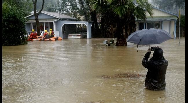
© AP/Marcio Jose SanchezA man is waste deep in water while taking cell phone images of rescue crews in Felton, CA.
Heavy rain and rapid snowmelt in the Sierra Mountains has led to widespread flooding in parts of Nevada and California, triggering numerous mudslides and road washouts. In Oroville, water opened up a massive hole in a dam.

Officials shut down flow from the Oroville Dam after chunks of concrete went flying from the spillway and created a 200-foot-long, 30-foot-deep hole on Wednesday. Officials stopped the water after noticing it was flowing irregularly and the erosion became apparent with the water held back.

The dam break poses no threat to the public but is expected to grow before engineers can make the necessary repairs, according to the Sacramento Bee.

High snow levels across parts of California and western Nevada have led to rain falling on areas where feet of snow have fallen in recent weeks, prompting flooding near the Sierras and in the central valley.

The final in a series of storms is making its way into the West Coast Thursday and Friday, said weather.com meteorologist Chris Dolce. Flood watches and warnings are posted from parts of Washington and Oregon southward into northern and central California.

Slideshow

Comment: Meanwhile...

Northeast US braces for biggest blizzard of the year

Historic U.S. winter storm dumps more than 5 feet of snow in parts of Montana


Cloud Precipitation

Warning issued to stay off roads as heavy rain causes flooding in Fiji

 The main Queens Road in Fiji's west flooded near Nadi
© Fiji Roads Authority The main Queens Road in Fiji's west flooded near Nadi
The authorities in Fiji are telling people to stay off the roads in the west and northwest of the main island as heavy rain continues to lash the country.

There is flooding in the towns of Tavua, Rakiraki, Nadi, and Lautoka.

A heavy rain warning remains in force and the flood alert continues for low-lying areas near major rivers around the country.

The tropical disturbance causing the deluge is southeast of Kadavu with forecasters saying another low is approaching Fiji from the west.

In Nadi, the river has burst its banks and parts off Lautoka are flooded as well.

An advisory councillor from Rakiraki, Nila Rao, said her community was still recovering from heavy flooding in December.


Bizarro Earth

Major slide blocks Highway 17, thousands without power, flooding reported in Santa Cruz, CA from 6 inches of rain in 24 hours

santa cruz ca mudslide
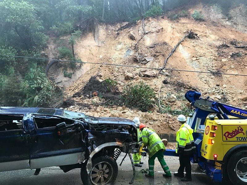
© Shmuel Thaler -- Santa Cruz SentinelArnie Huddin's Ford pick up truck is removed from Highway 17 after being destroyed by a mudslide north of Vine Hill Road on Tuesday, Feb. 7, 2017.
Highway 17 is closed in both directions through Tuesday night, Highway 9 is blocked in several areas, and flooding is reported throughout Santa Cruz County, with thousands without power after roughly 6 inches of rain fell the last 24 hours. The latest in a series of storms triggered mudslides, uprooted trees and knocked out power lines from south county lowlands to high in the Santa Cruz Mountains.

The San Lorenzo River breached its banks and flooded Highway 9 near Paradise Park about noon. The California Highway Patrol blocked Highway 9 near the Tannery Arts Center.

At about 1 p.m., Soquel Creek in Capitola Village rose to just a few feet from its banks near the river mouth at Capitola Beach. Aptos Creek in Rio del Mar had not crested and had not breached its banks by 1:30 p.m. near the mouth at Seacliff State Beach.

A massive mudslide struck three vehicles on Highway 17 at roughly 10:15 a.m., flipping one truck over, closing the highway and trapping hundreds of drivers unable to proceed. The California Highway Patrol has shut down both lanes of Highway 17 near Jarvis Road, according to CHP Officer Trista Drake, who said no one was hurt when the slide hit the vehicles. The highway near the slide area would be closed in both directions through Tuesday night, she said. "The hill is unstable and the slide keeps spilling over into the other lanes," Drake said.

Bizarro Earth

'I've never seen it go over Highway 9' - San Lorenzo River rising to major flood state between Santa Cruz and Felton, California

san lorenzo river flooding
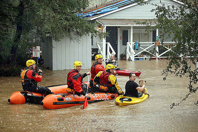
© Dan Coyro -- Santa Cruz SentinelBen Lomond Firefighters rescue Rachel Turner's dogs and escort her from her flooded home on Old Covered Bridge Road in Felton Tuesday morning when the San Lorenzo River hit flood stage.
The San Lorenzo River is overflowing its banks in several spots between Santa Cruz and Felton where the river rose to major flood stage. In downtown Santa Cruz, the river reached moderate flood stage -- 23.3 feet -- just after noon, and it's still rising, KSBW meteorologist Art Jarrett said.

Santa Cruz County officials sounded a flood warning siren Tuesday morning, notifying Felton Grove residents of impending danger. Firefighters rescued residents who were trapped inside their homes by flood waters. Reporter Phil Gomez witnessed the river overflowing onto Highway 9 at Sycamore Grove, just north of Santa Cruz. Sycamore Grove looks like a lake.

"Highway 9 is underwater. I've never seen the San Lorenzo River go over Highway 9," Gomez said.

County spokesman Jason Hoppin said, "We have several rivers at or approaching flood stage (San Lorenzo, Soquel and Corralitos), with rain expected to continue this afternoon. We are activating the Emergency Operations Center."

An atmospheric river flowing off the Pacific Ocean pounded Santa Cruz County with rain throughout Monday night and into Tuesday morning. More heavy rain is forecast for this afternoon, and county officials are bracing for more rivers and creeks possibly overflowing in a few hours.

"It's going to get worse before it gets better," Hoppin said.

KSBW Meteorologist Lee Solomon reported flash flooding in Paradise Park, and the Tannery Arts Center in Santa Cruz.

Solomon said, "The Santa Cruz Mountains have received a deluge. Way too much rain in a very short period of time. A flash flood is occurring in the Paradise Park area. Move to higher ground immediately."

NOAA's San Lorenzo River gauge at Big Trees recorded water levels rising to 23 1/2 feet at noon. The river's major flood stage is 21.8 feet, and minor flood stage is 16.1 feet.

Over in Scotts Valley, Highway 17 is closed in all directions. A mudslide caused one driver's SUV to flip and crash on Highway 17's northbound lanes, near Vinehill Road. The California Highway Patrol is diverting all drivers off the highway, and there is no estimated time for reopening.

"The slide is unstable," the CHP said.

Tuesday's atmospheric river-powered storm has so far caused more severe problems than the first atmospheric river that blasted the Central Coast in January.

"The ground is already soaked, so all of this rain is running into the riverbeds," Hoppin said.

He added that while the Pajaro River takes a long time to rise, the San Lorenzo River, Soquel Creek, and Corralitos Creek rise rapidly during storms.