Earthquakes
S


Bizarro Earth

2.5 magnitude earthquake rattles New Jersey, as residents heard 'explosion'-like booms

New Jersey earthquake
BERNARDSVILLE—After a 2.5 magnitude earthquake rattled parts of Somerset and Morris early Friday morning, borough residents recounted feeling booming, shaking and hearing what sounded like an explosion.

Patrons and employees of the Bagel Bin in downtown Bernardsville told NJ Advance Media they felt the earthquake early Friday morning, but no one said they'd sustained any damage to their homes or been injured.

Rich Green, a customer, said the earthquake shook his Mendham Road house, which was near the epicenter of the quake.

"It was a huge boom," he said. "The ground was shaking. My wife thought it was thunder, I thought it was some type of explosion."

Abby Chernin, a Bagen Bin employee, said she hadn't heard the earthquake, but her husband had jumped out of bed because of it.

Chernin said she asked her husband, "Are you going to make sure we weren't being robbed?" But, she said, then they realized what had actually happened.

Sari Mazen, another employee, said she, too, had initially thought it was thunder. Mazen said this was her second New Jersey earthquake in recent memory, the last occurring more than two years ago while she was on a beach in Belmar.
Bizarro Earth

USGS: Earthquake Magnitude 6.4 - 180km SE of Gizo, Solomon Islands

Gizo Quake_120815
© USGS
Time
  1. 2015-08-12 18:49:23 (UTC)
  2. Times in other timezones
Nearby Cities
  1. 180km (112mi) SE of Gizo, Solomon Islands
  2. 221km (137mi) W of Honiara, Solomon Islands
  3. 433km (269mi) SE of Arawa, Papua New Guinea
  4. 832km (517mi) E of Alotau, Papua New Guinea
  5. 833km (518mi) SE of Kokopo, Papua New
Scientific Data

Attention

Swarm of tremors in New Zealand indicates magma may be stirring

Image
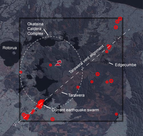
© GNS Science/ Erik KlemettiEarthquakes over the last 3 months in the Okataina region of New Zealand. The Tarawera vent alignment for volcanoes is marked along with the approximate boundary of the Okataina Caldera Complex. Red circles are locations of earthquakes.
Over the weekend, a small earthquake swarm hit in the Okataina Caldera Complex on the north island of New Zealand. The swarm itself only lasted a few hours and generated a few dozen earthquakes, all less than magnitude 3. The swarm was located directly underneath the Waimangu Geothermal Valley, the chain of hot springs, mudpots and geysers left by the 1886 eruption of Tarawera—the last eruption from the Okataina Caldera Complex. That 1886 eruption was an impressive event, creating one of the few, recent basaltic plinian eruptions that spread dark ash all the way into the Bay of Plenty. The Waimangu Valley itself is amazing, even if the world's largest geyser no longer erupts along its length.

Now, why would I bring up a small earthquake swarm in a volcanically active area? Mostly to show how rumbling like this is to be expected anywhere that has recent (and repeated) volcanism. The Okataina Caldera Complex has a multitude of eruptions over the last few thousand years, including the two that I've studied: the Kaharoa (~1300 AD) and Whakatane (5600 years ago). Most of the eruptions since 1886 have been steam-driven explosions that, as we've seen in the past, have little-to-no precursor. However, there is no doubt magma still underneath this area of the Okataina. The current earthquake swarm (which is already over) was located ~5-7 kilometers below the surface, which is likely the depth of the rhyolite magma body that fed the Kaharoa eruption.

Bizarro Earth

Half of population in U.S. vulnerable to earthquakes

Image
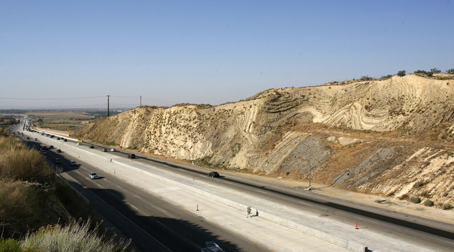
© Lucas Jackson / ReutersCalifornia's Antelope Valley freeway passes near folded layers of sediment above the San Andreas Fault near Palmdale, California
About 143 million Americans in the 48 contiguous states reside in areas vulnerable to earthquakes, with about nine percent, or 28 million, living in areas with a "high potential" for hazardous quakes.

Around 18 percent of Americans, or 57 million people, live in areas deemed "moderate" hazard zones, according to a new report published in journal Earthquake Spectra. The study utilized US Geological Survey data to predict which areas of the US were most at-risk.

The numbers are nearly twice that of the latest estimate from two decades ago that found about 75 million people in 39 states were exposed to a possible damaging quake.

The increase is due to an uptick in overall US population and the further concentration of population in especially risky areas like California, according to Mark Petersen, co-author of the study and chief of the USGS National Seismic Hazard Modeling Project. Advanced research methods have also added more earthquake risks, including the Cascadia Subduciton Zone in the Pacific Northwest.

Comment: The fact many studies and reports state that the West Coast is "overdue" for a massive quake should make this new report even more sobering to those who live there. Between San Andreas, Cascadia in the Pacific Northwest, and Yellowstone, there is the potential for a huge amount of damage and suffering if any or all of those at-risk areas experience a massive earthquake.


Bizarro Earth

Earthquake of 6.9-magnitude hits off Solomon Islands

A 6.9-magnitude earthquake struck off the Solomon Islands on Monday but there was no Pacific-wide tsunami warning issued for the tremor-prone region, the US Geological Survey said.

The shallow quake was centred some 186km southwest of Dadali and 214km from the capital Honiara. The Hawaii-based Pacific Tsunami Warning Center, which also measured the quake at 6.9, said "a destructive Pacific-wide tsunami is not expected".

Australian officials estimated the undersea quake at magnitude 6.8 and also said there was no tsunami threat.

"They would definitely have felt it over quite a wide area, over hundreds of kilometres," Geoscience's duty seismologist Hugh Glanville said of residents of the Solomon Islands. "But there shouldn't be a tsunami and hopefully not too much damage," he told AFP.

Bizarro Earth

5.6 magnitude earthquake hits eastern Democratic Republic of Congo, killing two children

usgs shake map DROC earthquake
A 5.6 magnitude earthquake that struck eastern Democratic Republic of Congo early on Friday killed at least three people, the government spokesman said.

The quake hit 24 miles (40 km) north of Bukavu, not far from the border with Rwanda, at 3:25 a.m. on Friday, said the U.S. Geological Survey, which initially reported the quake at magnitude 5.8.

"There were three deaths - two children in a house in Bukavu. There was also a police officer near the airport," government spokesman Lambert Mende told Reuters.

Attention

5.3 earthquake in Mexico Sea of Cortez

Image
© earthquake.usgs.gov
A 5.3 magnitude earthquake has struck off the coast of Mexico, USGS reported. The quake occurred 119 kilometers from the city of San José del Cabo.

The tremor took place 142 kilometers from the city of La Paz at 04:34 GMT. The town has a population of about 200,000 people and is 148 kilometers from Cabo San Lucas with nearly 70,000 inhabitants.

San José del Cabo, in the Mexican state of Baja California Sur, has a population of about 70,000 people.

Mexico is considered one of the most seismically active regions in the world and has a long history of earthquakes, USGS says.

In July 2014, at least five people were killed after a powerful 7.1-magnitude quake struck the southern Mexican state of Chiapas and neighboring Guatemala.

Attention

3.6 magnitude earthquake rocks parts of northern Oklahoma

Image
An earthquake has shaken parts of northern Oklahoma near the Kansas border.

The U.S. Geological Survey says the 3.6 magnitude earthquake was recorded at 3:28 p.m. about 11 miles south-southwest of Medford in Grant County. Medford is located about 85 north of Oklahoma City and 17 miles south of the Kansas border.

Geologists say the temblor occurred at a depth of about three miles.

No injuries or damage was immediately reported. Geologists say earthquakes of magnitude 2.5 to 3.0 are generally the smallest that are felt by humans and damage is not likely from earthquakes below magnitude 4.0.

The Oklahoma Geological Survey has said it is likely that many recent earthquakes in the state are being triggered by the injection of wastewater from oil and natural gas drilling operations.

Source: Associated Press

Attention

Magnitude 4 earthquake hits northern Italy

Image

Region NORTHERN ITALY

Date time 2015-08-01 20:47:53.3 UTC

Location 45.85 N ; 10.76 E

Depth 10 km

Distances 130 km E of Milan, Italy / pop: 1,306,661 / local time: 22:47:53.3 2015-08-01
37 km SW of Trento, Italy / pop: 104,946 / local time: 22:47:53.3 2015-08-01
3 km SW of Molina di Ledro, Italy / pop: 1,498 / local time: 22:47:53.3 2015-08-01

Source parameters reviewed by a seismologist

Attention

Magnitude 4.6 earthquake rocks Davao, Philippines

Image
© PhivolcsSanto Tomas, Davao del Norte felt the magnitude 4.6 quake at intensity IV.
The Philippine Institute of Volcanology and Seismology (Phivolcs) on Saturday evening reported a magnitude 4.6 earthquake in Davao del Norte.

The magnitude 4.6 earthquake with epicenter 28 kilometers northwest of Santo Tomas, Davao del Norte occurred at 11:17 p.m. on Saturday.

In its bulletin, Phivolcs said the quake with 8 kilometers depth of focus was felt at intensity IV in Santo Tomas, Davao del Norte and intensity III in Davao City.