Earthquakes
S

Attention

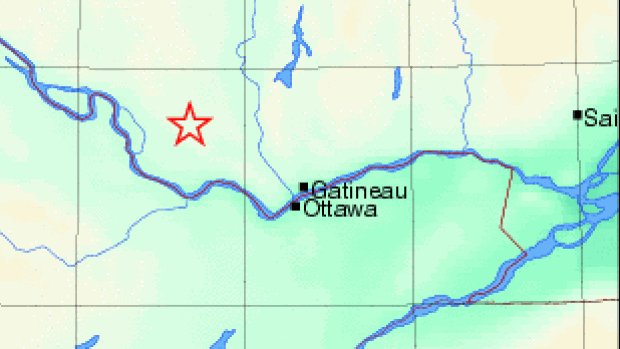
Magnitude 3.7 earthquake in western Quebec

Image
© Earthquakes CanadaA magnitude 3.7 earthquake registered at 3:17 p.m. ET in the area of Shawville, Que., on Sept. 9, 2015.
Earthquakes Canada reports a magnitude 3.7 quake near Gracefield, Que.

An earthquake registering at magnitude 3.7 shook an area in western Quebec on Wednesday afternoon.

Natrual Resources Canada reported the quake about three kilometres south-southwest of Gracefield, Que., which is a popular spot for earthquakes.

The federal agency said the quake, which hit at 3:17 p.m. ET on Wednesday, should not lead to damage due to its small scale.

Attention

5.5 magnitude earthquake jolts Islamabad, parts of Khyber-Pakhtunkhwa, Pakistan

Image
© AFP
An strong earthquake jolted Islamabad along with north-western parts of Khyber-Pakhtunkhwa early on Thursday morning, Express News reported.

According to the meteorological department, the earthquake, measuring 5.5 on the Ricther scale, was felt in the federal capital Islamabad, Rawalpindi, Peshawar, Abbottabad, Chitral and other mountainous regions.

According to the United States Geological Survey (USGS), the epicentre of the earthquake was just 36 kilometers north east of Hindu Kush region, Afghanistan at a depth of 93km.

However, there was no immediate reports of any loss of life or property.

Attention

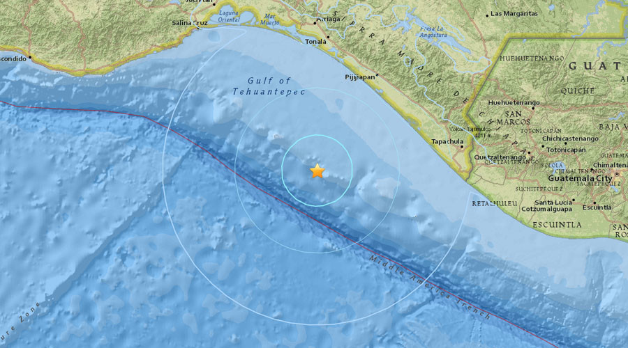
5.5 magnitude earthquake strikes off Mexican coast

Image
© usgs.gov
An earthquake with a magnitude of 5.5 on the Richter scale has struck off the Pacific coast of Mexico, the US Geological Survey reported. The quake occurred near the towns of Pijijiapan and Mapastepec.

The quake took place 135 kilometers from the town of Pijijiapan and 136 km from the town of Mapastepec.

Mexico, one of the world's most seismically active counties, has a long history of earthquakes, according to the USGS. In July 2014, five people died after a 7.1-magnitude quake struck the southern Mexican state of Chiapas and neighboring Guatemala.

Bizarro Earth

California faces threat of earthquake-triggered tsunamis

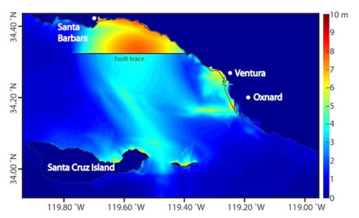
Map of localized peak tsunami amplitude_1
© Kenny Ryan, UC RiversideMap of regional peak tsunami amplitude in meters resulting from an earthquake on the Pitas Point and Lower Red Mountain fault system. The thin solid black line indicates the coastline and the thick black line indicates the Pitas Point fault trace.
Californians may be used to hearing about the threat of potentially deadly earthquakes, but a new study finds that quake-triggered tsunamis pose a greater risk to Southern California than previously thought.

Tsunamis are monster waves that can reach more than 100 feet (30 meters) high. They are often caused by earthquakes; the 2004 Banda Aceh earthquake and tsunami killed about 250,000 people, while the 2011 Tohoku earthquake and tsunami that struck offshore of Japan killed about 20,000 people and triggered a nuclear disaster.

Tsunamis increase in size as the depth of water in which they occur decreases. Since water depth is usually shallow near coastlines, tsunamis can grow as they approach land, becoming particularly dangerous along heavily populated coastlines, such as those in Southern California, the researchers said.

Scientists focused on the Ventura Basin in Southern California, which has offshore faults that can probably generate earthquakes of magnitude 7 or greater.

The researchers created 3D models of ruptures on the 31-mile-long (45 kilometers) Pitas Point and 22-mile-long (35 km) Lower Red Mountain undersea faults.

Although homes and buildings on the coastlines directly opposite these faults would naturally be vulnerable to any tsunamis, until now, additional low-lying areas farther to the east were not necessarily expected to be in harm's way. The new study suggests the cities of Ventura and Oxnard might be under greater threat of tsunami flooding than was previously thought.
X

Deep magnitude 6.1 earthquake registered south of Fiji Islands

Image
© USGS
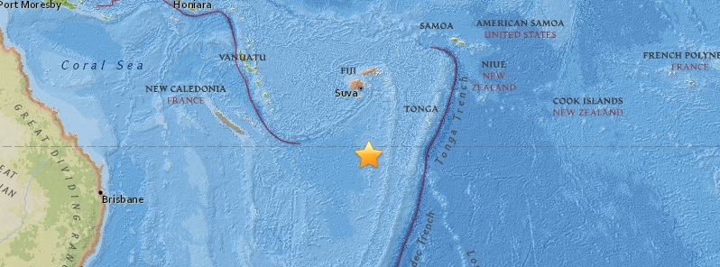
A very deep earthquake registered as M6.1 by Geoscience Australia hit south of Fiji islands at 08:46 UTC on September 7, 2015. The agency is reporting depth of 573 km (356 miles). USGS is reporting M5.3 at a depth of 547.3 km (340.1 miles).

According to the USGS, epicenter was located 451 km (280 miles) SSW of Ndoi Island, Fiji and 673 km (418 miles) WSW of Nuku'alofa, Tonga.

27 minutes later, at 09:13 UTC, both agencies registered another strong earthquake - M6.0 (Geoscience Australia) / M6.4 (USGS) - about 190 km (118 miles) SSE of L'Esperance Rock, New Zealand.
Image
© USGS

Attention

6.0 magnitude earthquake hits south of Kermadec Islands, New Zealand

Image
© USGS
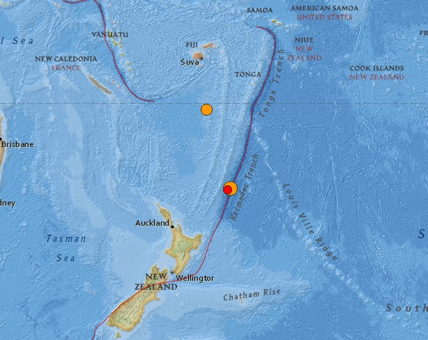
Geoscience Australia registered a shallow M6.0 earthquake (depth 0 km) south of Kermadec Islands at 09:13 UTC on September 7, 2015. USGS is reporting M6.4 at a depth of 35.4 km (22 miles).

According to the USGS, epicenter was located 191 km (119 miles) SSE of L'Esperance Rock and 725 km (450 miles) NE of Whakatane, New Zealand.

There are no people living within 100 km (62 miles) radius.

USGS issued green alert for shaking-related fatalities and economic losses. There is a low likelihood of casualties and damage.

Overall, the population in this region resides in structures that are resistant to earthquake shaking, though some vulnerable structures exist.

At 08:46 UTC today, a very deep earthquake registered as M6.1 by Geoscience Australia hit south of Fiji islands. The agency is reporting depth of 573 km (356 miles). USGS reported this quake as M5.3 at a depth of 547.3 km (340.1 miles). Epicenter was located 451 km (280 miles) SSW of Ndoi Island, Fiji and 673 km (418 miles) WSW of Nuku'alofa, Tonga, according to the USGS.

Attention

7-magnitude earthquake shakes Azerbaijan: Updated

Image
A 7-magnitude earthquake has shaken off Sheki, Azerbaijan, early Friday morning at 9:49AM.

The quake was magnitude 7 in the epicenter and up to magnitude 6.5 in residential areas nearby, the ANAS Republican Seismological Service Center told APA.

The quake occurred at a depth of 13 km.

10:03AM

A powerful earthquake has rocked Azerbaijan early this morning.

The quake was noticed in the districts of Ujar, Aghdash, Shamakhy, Zagatala, Balaken, Sheki, Gabala, Ismayilli, Tovuz, Salyan, Sabirabad, and in the cities of Shirvan and Mingachevir.

The ANAS Republican Seismological Service Center confirmed the fact to APA.

Note that, tremors were felt at the same time in Georgia. The epicenter is yet to be determined.

Info

CT scan of Earth links deep mantle plumes with volcanic hotspots

University of California, Berkeley, seismologists have produced for the first time a sharp, three-dimensional scan of Earth's interior that conclusively connects plumes of hot rock rising through the mantle with surface hotspots that generate volcanic island chains like Hawaii, Samoa and Iceland.

Essentially a computed tomography, or CT scan, of Earth's interior, the picture emerged from a supercomputer simulation at the Department of Energy's National Energy Research Scientific Computing Center (NERSC) at the Lawrence Berkeley National Laboratory.


While medical CTs employ X-rays to probe the body, the scientists mapped mantle plumes by analyzing the paths of seismic waves bouncing around Earth's interior after 273 strong earthquakes that shook the globe over the past 20 years.

Previous attempts to image mantle plumes have detected pockets of hot rock rising in areas where plumes have been proposed, but it was unclear whether they were connected to volcanic hotspots at the surface or the roots of the plumes at the core mantle boundary 2,900 kilometers (1,800 miles) below the surface.

Attention

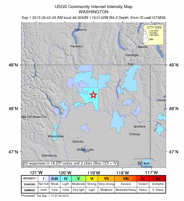
4.3 earthquake hits north central Washington wildfire zone

Image
A 4.3 magnitude earthquake has hit the wildfire zone in north central Washington.

The quake, which was six miles deep, hit 26 miles east of Okanogan and 25 miles north of Grand Coulee at 9:42 a.m. Tuesday, according to the Pacific Northwest Seismic Network.

KIRO 7 meteorolgist Morgan Palmer said an earthquake of that depth was considered shallow and was likely felt as a jolt.

The Pacific Northwest Seismic Network asks if you felt the earthquake, to fill out the form here.

Alarm Clock

Triple threat: Earthquakes rattle California, Oklahoma, Oregon

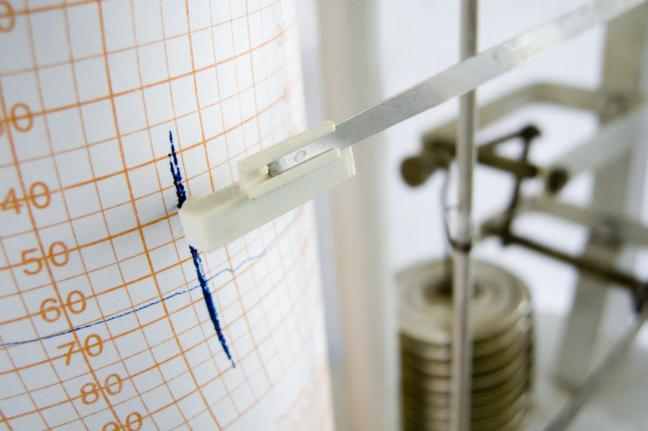
Seismograph
© fotandy/Shutterstock
COMPTON, Calif., Aug. 31 (UPI) -- No injuries or major damage was reported Monday after earthquakes rattled cities in California, Oklahoma and Oregon.

Around noon local time, a 2.9-magnitude earthquake rattled a location two and a half miles southwest of Compton, Calif. This report comes after news of a 2.6-magnitude earthquake that struck at 5:11 a.m. local time Sunday along the Hayward Fault in California's East Bay. Local residents reported feeling the quake, which is the latest in a series of rumbles along the fault scientists said could be precursors to a large temblor coming soon, KRON in San Francisco reported.