Earthquakes
S

Attention

Magnitude 4 earthquake hits northern Italy

Image

Region NORTHERN ITALY

Date time 2015-08-01 20:47:53.3 UTC

Location 45.85 N ; 10.76 E

Depth 10 km

Distances 130 km E of Milan, Italy / pop: 1,306,661 / local time: 22:47:53.3 2015-08-01
37 km SW of Trento, Italy / pop: 104,946 / local time: 22:47:53.3 2015-08-01
3 km SW of Molina di Ledro, Italy / pop: 1,498 / local time: 22:47:53.3 2015-08-01

Source parameters reviewed by a seismologist

Attention

Magnitude 4.6 earthquake rocks Davao, Philippines

Image
© PhivolcsSanto Tomas, Davao del Norte felt the magnitude 4.6 quake at intensity IV.
The Philippine Institute of Volcanology and Seismology (Phivolcs) on Saturday evening reported a magnitude 4.6 earthquake in Davao del Norte.

The magnitude 4.6 earthquake with epicenter 28 kilometers northwest of Santo Tomas, Davao del Norte occurred at 11:17 p.m. on Saturday.

In its bulletin, Phivolcs said the quake with 8 kilometers depth of focus was felt at intensity IV in Santo Tomas, Davao del Norte and intensity III in Davao City.

X

Manam Volcano erupts in Papua, New Guinea; spews ash 65,000 feet

Image
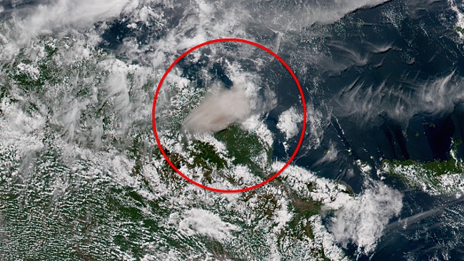
© Himawari-8/Japanese Meteorological Agency/NOAAA volcanic ash plume is shown off the coast of Papua New Guinea on Friday, July 31, 2015, after the Manam volcano erupted.
The Manam volcano in Papua New Guinea sent up a major eruption on Friday, local time, the first of its kind in almost 11 years.

Volcanic ash was sent 19,812 meters (65,000 feet) into the air as a result of the eruption, the Australian Bureau of Meteorology reported in an volcanic ash advisory. The plume was moving to the southwest but was spreading out in all directions.

A Code Red aviation advisory was issued as a result.

The eruption was reported around 1 p.m. Friday, local time (11 p.m. EDT).

The last major eruption of Manam, located 13 kilometers (8 miles) off the northern coast of Papua New Guinea, occurred in August 2004, according to the Global Volcanism Program at the Smithsonian Institution.

Attention

Queensland rocked by 2 earthquakes as powerful as an 'atomic bomb' - in strongest shakes in nearly 100 years

Image
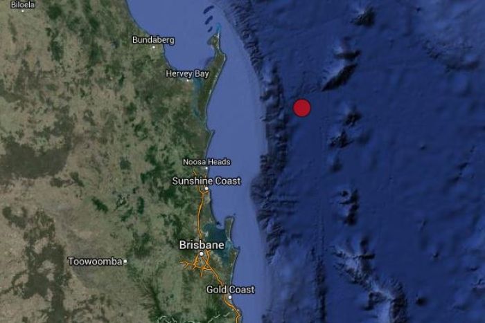
Geoscience Australia reported the initial earthquake struck 110 kilometres east of Fraser Island at a depth of 10 kilometres
Two earthquakes as powerful as an atomic bomb rocked Queensland on Saturday afternoon, in the state's largest event in almost 100 years.

A magnitude 5.7 event struck near Fraser Island, about 200 kilometres north of Brisbane, shortly after 1:30pm on Saturday, in what was the biggest such even to hit Queensland since 1918.

Little more than one hour later, another quake measuring 5.2 in magnitude struck the same area, which was then followed by an aftershock of about 3.

Geoscience Australia reported the initial earthquake struck 110 kilometres east of Fraser Island at a depth of 10 kilometres, and experts compared the quakes to the most damaging in Australian history.

'This is equivalent to the earthquake that occurred in 1989 in Newcastle, which of course is the most damaging earthquake in Australia's history,' Senior seismologist Dan Jaksa told the ABC.

It is estimated that the impact could have been felt by people up to 340km away.

Alarm Clock

Australia's Sunshine Coast shaken by record 5.3 magnitude earthquake

Queensland earthquake
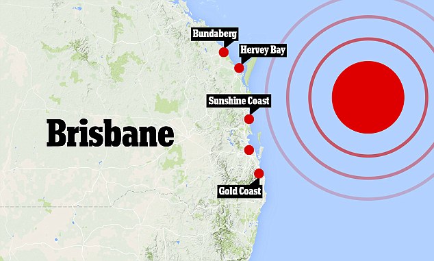
© Geoscience Australia)The magnitude-5.3 earthquake shook parts of south-east Queensland from Bundaberg down to the Gold Coast.

A magnitude-5.3 earthquake has hit off the Sunshine Coast in Australia.


A magnitude-5.3 earthquake has hit off the Sunshine Coast in Australia in what became the strongest quake registered in the region since the start of last century.

According to the US Geological Survey, the earthquake occurred at 23:41 GMT on Wednesday, its epicentre was located about 160 miles (260 kilometres) northeast of Brisbane.

Comment: Gothenburg was also rocked by an earthquake today, described by a Swedish seismologist as a "fairly big quake for Swedish conditions".

See also: Russian scientist: Slowdown in Earth's rotation means we're on the verge of major climatic upheaval


Galaxy

Best of the Web: Russian scientist: Slowdown in Earth's rotation means we're on the verge of major climatic upheaval

Image
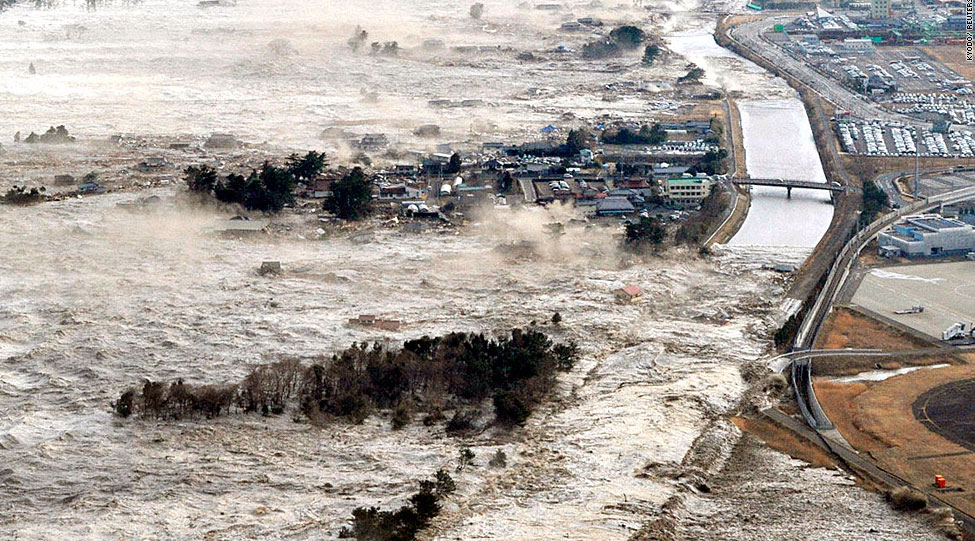
The 2011 tsunami in Japan was just part of the warm-up routine. The Really Big Show has yet to begin in earnest...
The world geological community is warning that today's seismic activity on our planet is nothing compared with what's to come.

Over the past three years, Pakistan, for example, has been hit by dozens of earthquakes. In March 2005, 80,000 people died under the rubble there. On October 30, the last time nature went on the rampage, there were hundreds of victims. Tens of thousands of people drowned during an overwhelming Asian tsunami at the end of 2004. China and Afghanistan have been rocked by quakes again more recently.

These natural disasters, which have swept our planet in recent years, indicate that the world has entered an era not only of a political, but also of climatic instability. Most scientists - biologists and environmentalists - tend to blame the human race for the catastrophic climate change on the Earth. No doubt, the greenhouse effect due to industrial activity plays a considerable role in global warming, but there are other reasons worth considering.

The Earth is rotating around its own axis slower. The International Earth Rotation Service has regularly added a second or two to the length of a 24-hour day in recent years.

Comment: An intriguing article, and very much in line with Sott.net's research over the years. It makes us wonder if Russian-Chinese plans to develop the relatively uninhabited Eurasian interior are being made with this kind of research in mind?

As for the overall model put forward by this Russian scientist, 'Earth-as-electrical-machine' suggests that all planets in the solar system together form a circuit. And, indeed, we observe 'Earth changes' on our nearest neighbours.

In between galactic influences and local geomagnetic influences on natural cyclical climate change, there are intermediary factors to consider, such as the role played by comets, cosmic ray flux, and the solar-system mechanism that 'sets the motor running'.

And don't forget that while there may be 'phases' to the process of climate shift, it is now believed to be far more abrupt than previously thought:
Ice Ages start and end so suddenly, "it's like a button was pressed," say scientists
Bizarro Earth

6.3 magnitude earthquake strikes Alaska near active volcano

earthquake in Alaska map
© earthquake.usgs.gov
A 6.3-magnitude earthquake has struck in Alaska, some 42 miles southwest of the active Redoubt Volcano, the US Geological Survey (USGS) has said.

Notably, the earthquake also struck near Mt. Katmai, the site of the largest volcanic eruption of the 20th century.

The epicenter was 9 miles south of Mt. Iliamna, another volcano in the area, the Alaska Dispatch News reported.

According to the USGS, the quake hit about 141 miles southwest of Anchorage.

The agency is forecasting "very light damage."

Bizarro Earth

USGS: Earthquake Magnitude 7.0 - 234km W of Abepura, Indonesia

Papua Quake_270715
© USGS
Time
  1. 2015-07-27 21:41:22 (UTC)
  2. Times in other timezones
Nearby Cities
  1. 234km (145mi) W of Abepura, Indonesia
  2. 247km (153mi) W of Jayapura, Indonesia
  3. 314km (195mi) W of Vanimo, Papua New Guinea
  4. 341km (212mi) ENE of Nabire, Indonesia
  5. 1195km (743mi) SSE of Koror Town, Palau
Scientific Data

Bizarro Earth

Magnitude 6.9 earthquake strikes off Alaska coast

earthquake off Alaska July 2015
© USGSM6.9 - 76km ESE of Yunaska Island, Alaska
A strong 6.9 magnitude quake hit off the coast of western Alaska near the Islands of Four Mountains, USGS reported.


The epicenter of the tremor on Monday was 76 km southeast of Yunaska Island, the largest island in a group in the chain of volcanic Aleutian Islands that stretch across the northern Pacific from the US to Russia, the report said.

The quake struck at a depth estimated to be 11.9 km. No tsunami alert was issued following the quake.

The Aleutian Islands run along the trench of the same name and comprise the northern part of the so-called Pacific Rim of Fire, an area of frequent seismic activity.

Comment: See also:

5 additional dead whales found in Alaska waters since June; total 14 dead
Active Week For Ring Of Fire As Earthquake Rattles Alaska
Why have 10 major volcanoes along the Ring of Fire suddenly roared to life?


Bizarro Earth

Magnitude 6.0 earthquake strikes off Indonesia, no tsunami threat

Indonesia earthquake 07_26_2015
© earthquaketracker.com
A strong 6.0-magnitude earthquake struck off the Indonesian island of Java today, the US Geological Survey reported, but local officials said there was no risk of a tsunami.

The quake struck at 2:05 pm local time (0705 GMT), 93 kilometres (57 miles) south of Krajan Tambakrejo village in east Java province at a depth of 59 kilometres, the USGS said.

Mochammad Riyadi, from the Indonesian meteorology, climatology and geophysics agency, said there were no reports of casualties or damages.

"The quake epicentre was in the sea, but there's no risk of a tsunami. It's quite a distance from nearby cities," he told AFP.

An AFP correspondent in Banyuwangi city in east Java said that mild shaking could be felt for about five seconds.

Indonesia sits on the Pacific "Ring of Fire" where tectonic plates collide, causing frequent seismic and volcanic activity.

Comment: See also:

Active Week For Ring Of Fire As Earthquake Rattles Alaska
Why have 10 major volcanoes along the Ring of Fire suddenly roared to life?