Earthquakes
S


Bizarro Earth

6.1 magnitude earthquake jolts southern Philippines

earthquake off philippines
A 6.1 magnitude earthquake shook several areas in Visayas and Mindanao Friday afternoon, state seismologist said.

The offshore quake struck 41 kilometers northeast of Burgos town in Surigao del Norte at 2:43 p.m., the Philippine Institute of Volcanology and Seismology (Phivolcs) said.

There were no immediate reports of damage or injury from the tremor that had a depth of 30 kilometers.

It was felt at Intensity V in Surigao City, Siargao Island, Talacogon, Agusan del Sur; Carrascal, Surigao del Sur.

Intensity IV in Dinagat Island; Intensity III in San Juan, Southern Leyte; Tacloban, Leyte; Palo, Leyte; Lapulapu City and Intensity II in Bislig, Surigao del Sur; Hinatuan, Surigao del Sur; Davao City.

The Philippines sits on the Pacific "Ring of Fire" where continental plates collide causing frequent seismic and volcanic activity.

With reports from Frances Mangosing, INQUIRER.net and Allan Nawal, Inquirer Mindanao

Question

Latest Michigan earthquake has scientists puzzled

Michigan earthquake
© U.S. Geological SurveyTemblor was a magnitude 3.3.
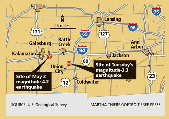
A 3.3-magnitude earthquake that struck 13 miles southeast of Battle Creek today has scientists scratching their heads.

Today's temblor was about 20 miles from the location of a magnitude-4.2 quake that occurred 5 miles south of Galesburg on May 2 — the strongest earthquake recorded in Michigan in more than 67 years. The two quakes are far enough apart that today's is likely not an aftershock of the previous quake and is apparently not on the same fault line, said Harley Benz, a seismologist with U.S. Geological Survey (USGS) in Colorado.

"After the May event, I suspected we wouldn't see another event, so I was a bit surprised by this one," he said. "What more surprised me is that they weren't in the same locations."

That also intrigues Eric Hetland, an assistant professor in the Department of Earth and Environmental Sciences at the University of Michigan.

"Given the close proximity in time to the earlier 4.2 (earthquake), and the low levels of seismicity in Michigan, it may be related to that earlier earthquake in some manner," he said.

Today's quake, which occurred about 11:43 a.m., was noted on the USGS website. The survey's Community Internet Intensity Map reported residents feeling the quake as far south as northern Indiana and as far north as Holland. The Calhoun County Sheriff's Office, in a news release, said dispatchers received several calls about the quake, but no damage had been reported.

The epicenter of the quake was the southeast corner of Warner Lake, 3.1 miles underground. The epicenter of the May 4 quake was in Galesburg, 3.4 miles below the surface.
Map

Cairo, Egypt smited with sandstorm and earthquake in one day; quake shakes Gaza Strip

Image
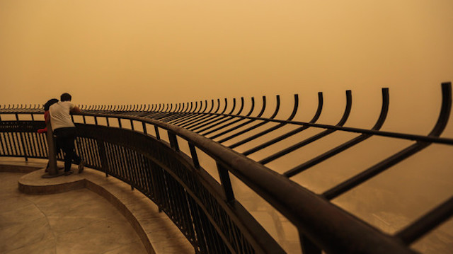
© APA couple observe a sandstorm that shrouds the capital city from an observation deck of the Cairo Tower in Zamalek, Cairo, Egypt, Saturday, June 27, 2015.
Egypt faced treacherous weather conditions Saturday as a sandstorm blanketed the north of the country and a magnitude-5.2 earthquake centered in the Sinai peninsula shook buildings more than 200 miles away in the capital, Cairo.

The epicenter of the quake was 4 kilometers (2.5 miles) southeast of the beachside town of Nuweiba in the Sinai, and about 75 kilometers (46 miles) south of Egypt's border with Israel, according to the U.S. Geological Survey.

Airports near Alexandria and Marsa Matrouh, along the Mediterranean coast, closed and diverted flights to Cairo due to poor visibility from the day's sandstorm, Civil Aviation Minister Hossam Kamel said in a statement. Visibility reached as low as 500 meters at the Burg al-Arab airport near Alexandria, he said.

Fierce winds whipped through the capital as many residents took cover from the sand by staying indoors. Others were seen braving the storm wearing surgical masks or covering their faces with clothing, as the wind sent rubbish and dust swirling.

At its peak, the sandstorm covered the capital in a thick orange cloud, dramatically reducing visibility.

Comment: 5.5 magnitude earthquake hits Israel; shaking reported in Cairo


Gold Seal

5.5 magnitude earthquake hits Israel; shaking reported in Cairo

Earthquake felt at 6:34 PM; epicenter reportedly south of Israel; strong shaking reported in Cairo
Image
© Ilan Uzan
An earthquake was felt in several Israeli cities at precisely 6:34 PM on Saturday. Uri Frieslander of the Israeli Geological Institute said the first station to log the quake was in Eilat.

The Israel Geological Survey reported that the earthquake measured a 5.5 on the Richter scale. It also reported that the epicenter was 90 kilometers south of Eilat. The American Geological Survey said it occurred on the East African Rift.

Israelis reported feeling the earthquake from cities such as Be'er Sheva, Tel Aviv, Hod Hasharon, Holon, Netanya, Jerusalem, and as far north as Nazareth Illit.

David Azulai, a resident of the town of Omer in the south said: "I was working on my computer, my feet where on the ground and I started feeling the ground move. It was clearly an earthquake; my partner was in bed and felt it too. It brought me back to memories of the big quake in the 90's. That was a serious earthquake. This time it was weak. I went to check on my partner to make sure she was alright."

Suzan from Ashkelon said; "we felt a light quake, my bed was moving about 2 minutes ago."

There have been three earthquakes just south of the current epicenter since 1900, ranging from 6 to 7 on the Richter scale. Al Jazeera reported that the quake had been strongly felt in Cairo. Reports from Jordan say that the quake was felt in Aqaba, and some of the residents left their homes as a result. Car alarms went off in some towns in Israel.

Bizarro Earth

Alaska shakes with force of a 5.8-magnitude earthquake after record spate of wildfires

Alaska quake
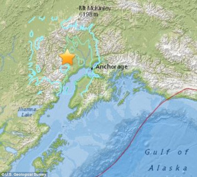
© US Geological SurveyQuake: This is the region that was struck by the 5.8-magnitude earthquake on Wednesday afternoon
Alaska was shaken by a a 5.8 magnitude earthquake on Wednesday afternoon.

The tremor, about 75 miles north west of Anchorage, shook buildings for about 15 to 20 seconds in the city at around 3.30pm.

There were no immediate reports of damage or injuries, Anchorage Police Department spokeswoman Anita Shell said.

The quake was initially recorded at a magnitude of 5.6, then was upgraded to 6.2, before the USGS settled on 5.8.

'Thought a moose was head-butting my camper,' Becky Woltjer, resident of nearby Willow, wrote on Facebook.

It comes after a wave of wildfires hit Alaska in May and the beginning of June.

Preliminary research suggested the quake was at a depth of 71.6 miles, originating in a remote mountainous region.

No tsunami was expected, despite its proximity to the coast.

Map

Another earthquake hits Sabah, Malaysia - 89th aftershock recorded since June 5th

Image
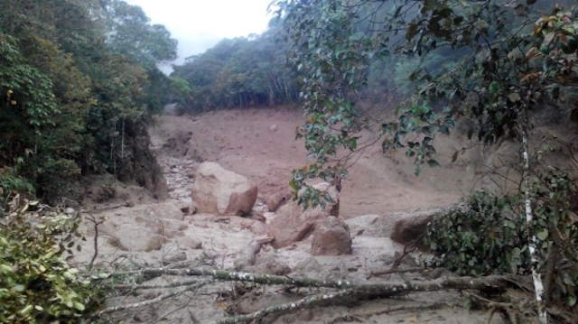
© Fire and rescue servicesMudslides at the foothills of Mount Kinabalu have seen boulders as big as fars flowing down the river and cut off road access between Mesilau and Kundasang.
Another tremor was felt in Sabah at 5.33pm today, making it the 89th aftershock since the deadliest earthquake in the country on June 5.

According to state Meteorological Department director Abdul Malek Tussin, the latest was a 4.3 magnitude earthquake, occurring some 19km northwest of Ranau, Sabah.

Mild tremors were felt as far away as Kota Kinabalu, Ranau, Kota Belud and Kundasang.

Sabah, particularly the Kundasang and Ranau regions, has been rocked by aftershocks — the biggest being 5.1 magnitude — since a 5.9-magnitude quake hit Sabah on June 5, killing 18 climbers on Mount Kinabalu.

Damage from the aftershocks so far include rockfall, mudslides, landslides and cracks to buildings including schools in the area.

Villagers at the foothills of mount Kinabalu have been traumatised by the quake and its subsequent aftershocks, many claiming they are not able to sleep at night for fear of another quake.

Dominoes

Magnitude 6.0 earthquake hits east of Ndoi Island, Fiji

Image
© USGS20.457°S 178.351°W depth=561.4 km (348.8 mi)
Time
  1. 2015-06-21 21:28:16 (UTC)
  2. 2015-06-21 17:28:16 (UTC-04:00) in your timezone
  3. Times in other timezones

Nearby Cities
  1. 42km (26mi) ENE of Ndoi Island, Fiji
  2. 336km (209mi) WNW of Nuku'alofa, Tonga
  3. 423km (263mi) SE of Suva, Fiji
  4. 507km (315mi) SSE of Lambasa, Fiji
  5. 533km (331mi) SE of Nadi, Fiji

Post-It Note

Scientists find 'unprecedented' evidence African continent capable of megaquakes

Image
© James Cook University
Lead researcher Hannah Hilbert-Wolf and supervisor Dr. Eric Roberts used innovative methods to examine the ground around Mbeya in Tanzania where a large earthquake occurred some 25,000 years ago.

They found evidence of fluidisation (where soil behaves like quicksand) and upward displacement of material unprecedented in a continental setting, raising questions of how resilient the rapidly growing cities of the region would be in a major shake.

'We can now use this to evaluate how the ground would deform in a modern earthquake,' said Dr. Roberts. 'This is important because the approach is inexpensive and can be used to model how structures might be affected by future events, providing a valuable tool in hazard assessment.'

Hilbert-Wolf said the team found evidence of massive ground deformation and previously unknown styles of liquefaction and fluidisation, caused by past earthquakes. 'This could be a major concern for the growing urban population of East Africa, which has similar tectonic settings and surface conditions,' she said.

The study comes on the back of a series of damaging earthquakes already this year, including in Nepal and Papua New Guinea and the study may be of much use in predicting the effects of earthquakes in those countries.

'What we have shown is that in developing countries in particular, which may lack extensive seismic monitoring, the rock record can be used to not only investigate the timing and frequency of past events, but also provide important insights into how the ground will behave in certain areas to seismic shock,' said Hilbert-Wolf.

Bizarro Earth

USGS: Earthquake Magnitude 6.4 - 76km NW of Talcahuano, Chile

Talcahuano Quake_200615
© USGS
Time
  1. 2015-06-20 02:10:06 (UTC)
  2. Times in other timezones
Nearby Cities
  1. 76km (47mi) NW of Talcahuano, Chile
  2. 83km (52mi) WNW of Tome, Chile
  3. 87km (54mi) WNW of Penco, Chile
  4. 88km (55mi) NW of Concepcion, Chile
  5. 430km (267mi) SW of Santiago, Chile
Scientific Data

Hardhat

Dramatic increase in earthquakes in central and eastern U.S. due to oil industry's high-rate injection wells

earthquakes oil gas wells
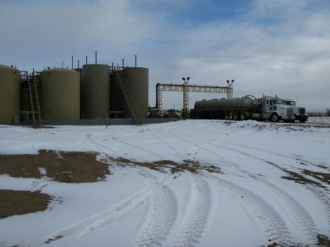
© Bill Ellsworth, USGSA new study ties high-rate injection wells like this salt water disposal well in Colorado to enormous earthquake increase.
A dramatic increase in the rate of earthquakes in the central and eastern U.S. since 2009 is associated with fluid injection wells used in oil and gas development, says a new study by the University of Colorado Boulder and the U.S. Geological Survey.

The number of earthquakes associated with injection wells has skyrocketed from a handful per year in the 1970s to more than 650 in 2014, according to CU-Boulder doctoral student Matthew Weingarten, who led the study. The increase included several damaging quakes in 2011 and 2012 ranging between magnitudes 4.7 and 5.6 in Prague, Oklahoma; Trinidad, Colorado; Timpson, Texas; and Guy, Arkansas.

"This is the first study to look at correlations between injection wells and earthquakes on a broad, nearly national scale," said Weingarten of CU-Boulder's geological sciences department. "We saw an enormous increase in earthquakes associated with these high-rate injection wells, especially since 2009, and we think the evidence is convincing that the earthquakes we are seeing near injection sites are induced by oil and gas activity."

Comment: