Earthquakes
S


Bizarro Earth

USGS: Earthquake Magnitude 6.4 - Izu Islands, Japan region

Izu Quake_300515
© USGS
Time
  1. 2015-05-30 18:49:07 (UTC)
  2. Times in other timezones
Nearby Cities
  1. 398km (247mi) SE of Hachijo-jima, Japan
  2. 546km (339mi) SSE of Katsuura, Japan
  3. 552km (343mi) SSE of Tateyama, Japan
  4. 552km (343mi) SSE of Kawaguchi, Japan
  5. 627km (390mi) SSE of Tokyo, Japan
Scientific Data

Comment:


Bizarro Earth

New study finds major faults offshore in southern California could trigger large earthquakes, tsunamis

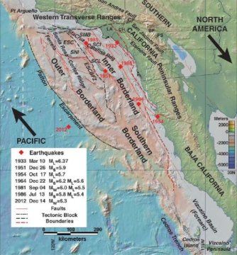
map california borderland
© Mark LeggThis map shows the California Borderland and its major tectonic features, as well as the locations of earthquakes greater than Magnitude 5.5. The dashed box shows the area of the new study. Large arrows show relative plate motion for the Pacific-North America fault boundary. The abbreviations stand for the following: BP = Banning Pass, CH = Chino Hills, CP = Cajon Pass, LA = Los Angeles, PS = Palm Springs, V = Ventura; ESC = Santa Cruz Basin; ESCBZ = East Santa Cruz Basin Fault Zone; SCI = Santa Catalina Island; SCL = San Clemente Island; SMB = Santa Monica Basin; SNI = San Nicolas Island.
While their attention may be inland on the San Andreas Fault, residents of coastal Southern California could be surprised by very large earthquakes -- and even tsunamis -- from several major faults that lie offshore, a new study finds.

The latest research into the little known, fault-riddled, undersea landscape off of Southern California and northern Baja California has revealed more worrisome details about a tectonic train wreck in the Earth's crust with the potential for magnitude 7.9 to 8.0 earthquakes. The new study supports the likelihood that these vertical fault zones have displaced the seafloor in the past, which means they could send out tsunami-generating pulses towards the nearby coastal mega-city of Los Angeles and neighboring San Diego.

"We're dealing with continental collision," said geologist Mark Legg of Legg Geophysical in Huntington Beach, California, regarding the cause of the offshore danger. "That's fundamental. That's why we have this mess of a complicated logjam."

Legg is the lead author of the new analysis accepted for publication in the Journal of Geophysical Research: Earth Surface, a journal of the American Geophysical Union. He is also one of a handful of geologists who have been trying for decades to piece together the complicated picture of what lies beyond Southern California's famous beaches.

X

Earthquake strikes California - 5.5 magnitude near Brooktrails

Image
© Bing maps
A shallow magnitude 5.5 earthquake was reported Saturday morning seven miles from Brooktrails, Calif., according to the U.S. Geological Survey. The temblor occurred at 4:33 a.m. PDT at a depth of 23.6 miles.

According to the USGS, the epicenter was 27 miles from Ukiah, 60 miles from Clearlake and 68 miles from Healdsburg.

In the l10 days, there has been one earthquake of magnitude 3.0 or greater centered nearby.

This information comes from the USGS Earthquake Notification Service and this post was created by an algorithm.

Comment: Updated later today:

9:02 a.m.: This post is incorrect, with the USGS reporting that sensors in California misidentified seismic activity from a magnitude 7.8 quake that struck off the coast of Japan several minutes earlier.

"It's bogus," said John Bellini, a USGS geophysicist. "When the waves from these big quakes hit [the Northern Californian sensor] network they think it's a local quake. They have some kind of filtering system, but it's not working properly. There is some problem with that on their end."


Attention

4.8 magnitude earthquake hits near San Simeon, California

Image
© Bing maps
A magnitude 4.8 earthquake was reported Saturday morning 13 miles from San Simeon, Calif., according to the U.S. Geological Survey. The temblor occurred at 4:33 a.m. PDT at a depth of 54.1 miles.

According to the USGS, the epicenter was 27 miles from King City, 33 miles from Greenfield and 34 miles from Paso Robles.

In the last 10 days, there have been three earthquakes of magnitude 3.0 or greater centered nearby.

This information comes from the USGS Earthquake Notification Service and this post was created by an algorithm.

Attention

6.8 magnitude earthquake strikes offshore Alaska -USGS

earthquake off Alaska

A 6.8-magnitude earthquake has struck the coast of Alaska, the US Geological Survey said Friday.


The quake's epicenter was situated 63 miles of the island of Chirikov located to the west of Nome on Alaska's mainland.


No tsunami warnings have been issued and there are so far no reports of damage from the earthquake.

Comment: In the last week, Alaska has also experienced more chaotic weather with record heat in some parts, and 'epic' flooding in others.


Bizarro Earth

Red Sea parts for 2 new islands

Sholan Island
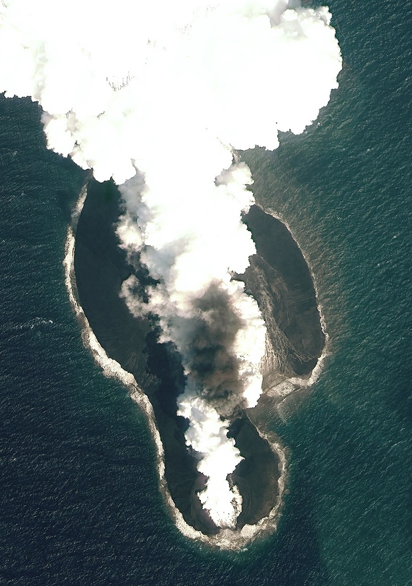
© Jónsson et al., Nature CommunicationsA 2011 satellite photo of the eruption that created Sholan Island.
Two volcanic islands recently born in the Red Sea have yielded stunning images, providing scientists with new insights about a little-known rift in Earth's crust.

Both islands emerged in the Zubair Archipelago, a small chain of volcanic islands, owned by Yemen, that rise from the Red Sea between Africa and the Arabian Peninsula. The first of the new islands, now called Sholan Island, appeared in December 2011. The second island, called Jadid, surfaced in September 2013.

The Red Sea is an enormous crack in the Earth's crust called a rift, where the African and Arabian tectonic plates are tearing apart at about 0.4 inches (1 centimeter) per year. At a rift, the crust stretches apart slowly over centuries, like a piece of taffy candy, but it also sometimes suddenly splits when the strain becomes too great. For instance, in 2005, in nearby Afar, Ethiopia, giant fissures and fiery lava flows appeared in the rift zone after a series of earthquakes.

The new volcanic activity that formed these islands in the Red Sea could herald a rifting episode akin to that seen in Afar, said study co-author Sigurjón Jónsson, a geophysicist at the King Abdullah University of Science and Technology in Thuwal, Saudi Arabia.

Attention

Magnitude 3.0 earthquake recorded in North Wales

Anglesey earthquake
© British Geological SurveyA seismograph shows the magnitude 3.0 earthquake that struck Anglesey

British Geological Survey records earthquake off Anglesey in North Wales just days after 4.2 magnitude quake hits Kent


An earthquake measuring magnitude 3.0 on the Richter scale has hit Anglesey in North Wales.

The British Geological Survey (BGS) said it was recorded at 4.41pm on Tuesday and struck off the coast about four miles (6km) below the surface.

North Wales Police said it received calls about the earthquake, which was recorded close to Caernarfon Airport in Gwynedd, but there are no reports of damage.

It follows a 4.2 magnitude earthquake that was recorded in Kent on Friday, becoming Britain's biggest in seven years.

Location of the earthquake off North Wales
© Google MapsLocation of the earthquake off North Wales
The latest quake was felt across Gwynedd and Anglesey, with witnesses reporting having felt the earth shake amid a "rumbling noise" that lasted for around three seconds.

Others said they heard a noise that sounded like an explosion.


Bizarro Earth

Is 'San Andreas' a cryptic warning about what is going to happen in America's future?

San Andreas Movie Poster
© endoftheamericandream.comSan Andreas Movie Poster.
Hollywood has a long history of inserting political messages, social commentaries, subliminal effects and even cryptic warnings about the future into big budget films. So is someone attempting to use San Andreas to tell us something? For many years, doomsayers have been warning that the "Big One" is going to come along and rip the coastline of California to shreds. Up until this moment, it hasn't happened, but without a doubt we have moved into a time of increased geological activity all over the globe. As you read this article, 42 volcanoes around the planet are currently erupting. That means that the number of volcanoes erupting right now is greater than the 20th century's average for an entire year. In addition, we have been witnessing a great deal of very unusual earthquake activity lately. Just in the United States, we have seen unusual earthquakes hit Michigan, Texas, Mississippi, California, Idaho And Washington within the last month or so. Could it be possible that our planet has entered a period of heightened seismic activity? And could it also be possible that someone behind San Andreas is aware of this and is trying to warn us about what is coming in our future?

Of course just about everyone in the scientific community acknowledges that the "Big One" is eventually coming to California. In fact, the U.S. Geological Survey recently came out and said that the probability of a megaquake along the west coast is greater than they had previously been projecting...
A recent report by the U.S. Geological Survey shows the inevitability of just such a quake, which is predicted to hit within the next couple of decades.

"The new likelihoods are due to the inclusion of possible multi-fault ruptures, where earthquakes are no longer confined to separate, individual faults, but can occasionally rupture multiple faults simultaneously," lead author of the study and USGS scientist, Ned Field says. "This is a significant advancement in terms of representing a broader range of earthquakes throughout California's complex fault system."
And it is undeniable that California has been hit by an unusual number of earthquakes recently. Could this be a sign that our portion of the "Ring of Fire" is heating up? Just over the past few days, there have been significant earthquakes at dormant volcanoes all over the state of California and in Nevada. I don't know about you, but to me all of this shaking is reason for concern.

Arrow Up

Swarm of twenty-three earthquakes reported near Costa Rica's Irazu volcano

Image
© Tico Times/GoogleThe epicenters of 23 temblors are in an area near the Irazú Volcano.
In a span of eight hours on Monday night and into early Tuesday, experts from the University of Costa Rica and the National University registered at least 23 temblors with epicenters located north of the province of Cartago, some 22 kilometers northeast of the Costa Rican capital.

Ronny Quintero, a seismologist at UNA's Volcanological and Seismological Observatory of Costa Rica (OVSICORI) reported that the temblors originated on local faults west of Irazú Volcano's main crater. Experts said they are not directly related to the volcano's activity. The first occurred at 8:19 p.m. with a magnitude of 3.1 and and an epicenter 10 kilometers northwest of Pacayas. Several minor earthquakes with magnitudes ranging from 2.4 to 3.7 followed, mainly in areas north and east of Cartago in the cantons of Jiménez and Oreamuno. Most of the minor quakes went unnoticed by local residents.

The strongest, at magnitude-4.2, was registered at 8:50 p.m. with an epicenter 9 kilometers northeast of San Rafael de Oreamuno. The most recent was reported at 7:09 a.m. on Tuesday with a magnitude of 2.4. OVSICORI received reports from residents throughout the Central Valley who felt at least three of the temblors, but there has been no significant damage or injuries.

Attention

Magnitude 5.6 earthquake rattles Tokyo

No immediate reports of damage, tsunami after magnitude 5.5 quake

An aerial view of the Tokyo.
© Getty ImagesAn aerial view of the Tokyo.
TOKYO - A powerful earthquake shook central Tokyo on Monday afternoon, causing the temporary suspension of some bullet trains and the closure of airport runways at one of the capital's air hubs.

There was no danger of a tsunami and no initial reports of any damage, according to national broadcaster NHK.

The magnitude 5.6 quake, centered north of Tokyo, struck at 0528 GMT. It measured a lower 5 on Japan's earthquake intensity scale in southern Ibaraki prefecture, northeast of Tokyo. The intensity scale has a highest reading of 7.

Narita International Airport temporarily closed its two runways following the quake, but Haneda airport, located closer to the center of Tokyo, was running flights as scheduled, according to NHK.

Some bullet shinkansen train services were temporarily suspended following the temblor, NHK also said.

There were no reports of irregularities at the Tokaimura nuclear plant in southern Ibaraki, the national broadcaster said.