This is a fascinating event for several reasons. First, flash-freezing is a very peculiar process that does not really occur on our planet. Also, given the death circumstances, the magnitude and power involved to virtually wipe out the whole mammoth genus is truly astounding.
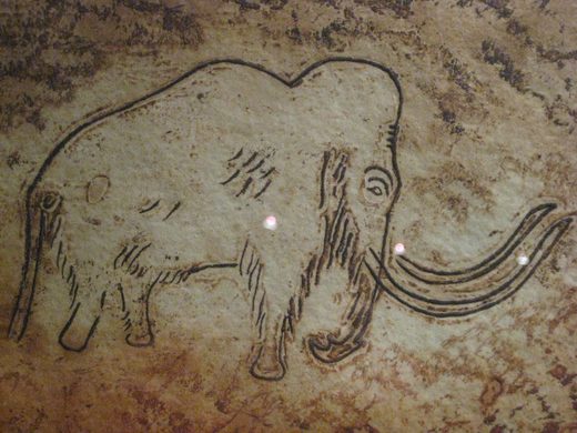
But maybe the most fascinating aspect of this event is that it occurred just 13,000 years ago when the human race was already widely established on planet Earth. For comparison, the upper paleolithic cave paintings found in Southern France (Lascaux, Niaux, Rouffignac,...) were made 17,000 to 13,000 years ago.
This event challenges our uniformitarian vision of history where the progress of life on our planet is a linear process, increasing day after day, undisturbed by any major external setback. Therefore such an event casts a different light on our human condition and the pervasive delusion that human beings are some kind of all-mighty creatures that are above natural laws, including those that govern major catastrophes.
It is a fascinating and puzzling topic because the numerous theories that have been proposed over the last two centuries to explain the demise of the woolly mammoths - such as them being caught in frozen rivers, victims of over-hunting, covered by hail storms, buried in mudslides, fallen in ice crevasses, caught by the ice age - are not sufficient to fully explain this mass extinction.
So, in the following article, I will try to provide explanations about how and why millions of woolly mammoths ended up flash-frozen overnight.
The Woolly Mammoths
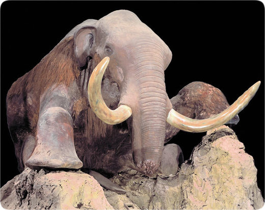
The woolly mammoth is a close cousin of the modern elephant. Its size was similar to the African elephant, males reaching shoulder height of about 3 m (10 ft) and weighing up to 6 tonnes.
The mammoths had a plant-based diet and a fully grown male would need to eat about 180 kg (400 lb) of food daily.
At the time, woolly mammoths were very abundant on our planet. To illustrate this point, between 1750 and 1917, trade in mammoth ivory prospered over a wide geographical region, yielding an estimated 96,000 mammoth tusks. It is estimated that about 5 million mammoths lived in just a small portion of northern Siberia.
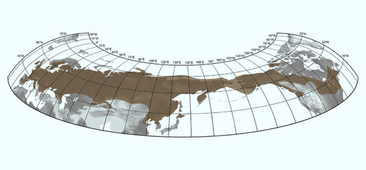
Before their extinction, woolly mammoths inhabited wide portions of our planet. Remains have been found all over Northern Europe, Northern Asia and Northern America.
Woolly mammoths were not the new kid on the block either; they had been roaming the planet for six million years before modern elephants and woolly mammoths split into separate species.
A prejudiced interpretation of the hairy and fatty nature of the creature, and a belief in unchanging climatic conditions led scientists to deem the woolly mammoth a creature of cold areas of our planet. But furry animals don't necessarily live in a cold climate - see, for example, desert animals like camels, kangaroos and fennecs. They are furry and they live in hot or temperate climates. In fact, most furry animals could not survive arctic weather.
What makes for successful cold adaptation is not fur per se but its erectile nature which traps a layer of air for thermal insulation against the cold. Unlike the fur seal for example, mammoths were devoid of erectile fur.
Another factor in the protection of animals against damp and cold is the presence of sebaceous glands, which secrete oil on the skin and in the fur, offering protection against dampness.
The woolly mammoth had no sebaceous glands and its dry hair would have allowed much snow to touch the skin, melt, and dramatically increase the heat loss (the thermal conductivity of water is about twelve times higher than the conductivity of snow).
As suggested by the picture on the right, the fur of the mammoth was not very dense. For comparison, the fur of the yak (a cold-adapted Himalayan mammal) is about 10 times thicker.
In addition, the mammoths had hair hanging down to their toes, yet every arctic animal has fur, not hair on their toes. Hair would have caused snow to cake on its ankles and hinder walking.
The above clearly shows that fur is not a proof of cold-adaptation and neither is fat. Fat only proves that food is plentiful. A fat, overfed dog could not withstand an arctic blizzard and its -80F (-60° Celsius) temperatures. On the contrary, creatures like arctic rabbits or caribous can, despite their relative low fat to body mass ratio.
Mammoths remains are usually found piled up with other animals, like tiger, antelope, camel, horse, reindeer, giant beaver, giant ox, musk sheep, musk ox, donkey, badger, ibex, woolly rhinoceros, fox, giant bison, lynx, leopard, wolverine, hare, lion, elk, giant wolf, ground squirrel, cave hyena, bear, and many types of birds. Most of those animals could not survive the arctic climate. This is an extra indication that woolly mammoths were not polar creatures.
French prehistorian Henry Neuville conducted the most detailed study of mammoth skin and hair. At the end of his thorough analysis, he wrote the following:
"It appears to me impossible to find, in the anatomical examination of the skin and [hair], any argument in favor of adaptation to the cold."Last, but not least, the mammoth's diet argues against the creature existing in a polar climate. How could the woolly mammoth sustain its vegetarian diet of hundreds of pounds of daily intake in an arctic region devoid of vegetation for most of the year? How could woolly mammoths find the gallons of water that they had to drink everyday?
- H. Neuville, On the Extinction of the Mammoth, Annual Report of the Smithsonian Institution, 1919, p. 332.
To make things worse, the woolly mammoth lived during the ice age, when temperatures were colder than today. Mammoths could not have survived the harsh northern Siberia climate of today, even less so 13,000 years ago when the Siberian climate should have been significantly colder.
The evidence above strongly suggests that the woolly mammoth was not a polar creature but a temperate one. Consequently, at the beginning of the Younger Dryas, 13,000 years ago, Siberia was not an arctic region but a temperate one.
The Younger Dryas
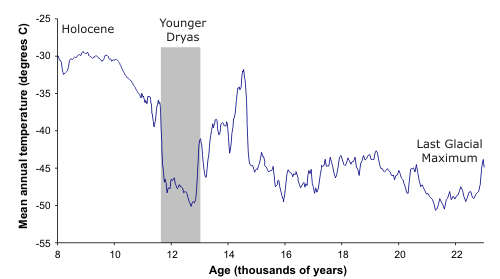
The Younger Dryas is named after a flower (Dryas octopetala) that grows in cold conditions and became common in Europe during this period that started around 10,900 BC (i.e. 12,900 years ago) and lasted for about 1,000 years. The Younger Dryas marks the transition between the Pleistocene epoch and our current epoch, known as the Holocene. The Younger Dryas saw a sharp decline in temperature over most of the Northern Hemisphere. It was the most recent and longest interruption to the gradual warming of the Earth's climate. To give an idea of the magnitude of the cooling, the Greenland ice core GISP2 indicates that, at its height, it was approximately 15 °C (27 °F) colder during the Younger Dryas than it is today.
Notice, however, that the overall cooling that occurred during the Younger Dryas was not homogeneous, and while some regions experienced a marked cooling (Siberia, Europe, Greenland, Alaska), other regions experienced a relative warming (Northern America, apart from Alaska, and the 'Asian' side of the Antarctica). This is an important point that we'll explore soon.
Along with the drastic temperature drop, one of the major features of the Younger Dryas is a massive die-off: 35 mammals (mastodons, giant beavers, saber-toothed cats, giant sloths, woolly rhinoceroses, etc) and 19 genus of birds became extinct in a very short time period.
Hibben estimates that as many as 40,000,000 animals died in North America alone. In total, hundreds of millions of mammoths were killed. Remains were found all across Northern Russia from the Urals to the Bering Strait and even on the American continent (Alaska and Yukon). Only two small pockets of mammoths remained: St. Paul Island until 5,600 years ago and Wrangel Island until 4,000 years ago.
Human populations were already quite widespread at the time (Yurok, Hopies, Kato, Arawaks, Toltecs, Incas...), and at least one of them, the Clovis people who inhabited Northern America, was erased from the face of Earth during this period of turmoil.
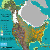
The Clovis people were not a small localized tribe; their implantation sites cover most of Northern America, as indicated by the geographic range of their artifacts, particularly fluted points (see map on the right).
The crime scene
The broad geographic scale of the extinction and its relatively recent occurrence provide a lot of scientific material. In the numerous excavations conducted over most parts of the Northern hemisphere, the burial sites of the woolly mammoths reveal the very same features again and again:
- Soot: a concentration peak in charcoal and soot was found in several Clovis sites and in the Younger Dryas strata.
- Fullerenes: a pure form of carbon like graphite and diamond. It is a large spheroidal molecule consisting of a hollow cage of sixty or more atoms of carbons. High concentrations of fullerenes were found in the 12,900 BP strata.
- Potassium 40: Potassium-40 is a naturally radioactive isotope with a 1.3-billion-year half-life that represents a tiny fraction of all potassium on Earth. This amount is very uniform throughout the solar system, except for meteorites, comets, or when a supernova is involved. Peak concentration of this isotope was found in the Clovis strata.
- Helium-3: A typical extraterrestrial impact marker. Helium-3 is rare on Earth but common in extraterrestrial material. The connection between asteroid impacts and helium-3 was demonstrated by Becker et al, who located a 25-mile-wide impact site called the Bedout crater that dates to the Permian extinction, 250 million years ago, and revealed high levels of helium-3. Similarly, the Younger Dryas boundary contains peak concentrations of helium-3.
- Thorium, Titanium, Cobalt, Nickel, Uranium and other rare earth elements: High concentrations of these elements were found in the Younger Dryas strata, Clovis sites and several meteorite craters. These rare elements are seldom found on Earth but they are very common in meteorites.
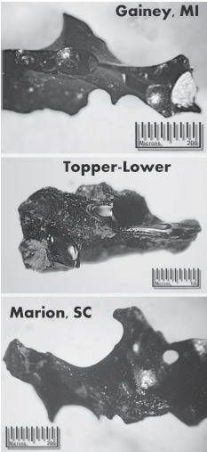
- Carbon glass: the 12,900 BP strata is characterized by a high concentration of this form of black glass that is rich in carbon. Testing showed that the carbon glass samples included numerous internal gas bubbles. This is an indication of extraordinarily high temperatures followed by very sudden cooling. If carbon is pure, it melts at 6,400 degrees Fahrenheit. Only extraordinary events can create such temperatures. Carbon glass is only found in the Clovis-era layer.
- Iridium: an extremely rare element in the Earth's crust but an element that is typically found in meteorites and cometary material. The geological strata relating to notable cometary bombardments (Dinosaur Extinction, dated at 65 million years BP, commonly referred to as the Cretaceous-Tertiary (K-T) Extinction, as well as the Triassic-Jurassic Extinction, which occurred approximately 200 million years BP, exhibit abnormally high concentrations of iridium.
- Nano diamonds: Millions of microscopic diamonds were found in Clovis sites. Hexagonal nano diamonds require pressures of 2 million psi (170000 bars) and temperatures between 1,000-1,700°C followed by rapid quenching.
- Spherules: hollow magnetic floating balls exhibiting a high concentration in carbon were found in most Clovis-era sites. This form of carbon requires very high temperature and pressure to form. These spheres are tiny, measuring from 10 to 50 micrometers in diameter but very frequent in the Younger Dryas boundary where thousands of microspherules were found in each kilogram of dirt.
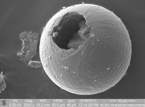
Exotic materials like carbon glass, spherules, microscopic diamonds and fullerenes tell a similar story. They indicate exceptionally high temperatures and pressures that don't occur on Earth except during extreme events like asteroid impacts. All this material was found in high concentration in impact sites and in the Clovis strata.
Below, Firestone summarizes the results of years of research conducted in numerous geological sites across Europe and America.
"In stratified sections at each of 10 [Younger Dryas] sites, from California to Belgium and Manitoba to Arizona, we found a <5-cm-thick sediment layer dated ca. 12.9 ka that contained a majority of 14 markers, forming distinct stratigraphic peaks at above-background concentrations.Along with the Younger Dryas boundary, there is a second boundary that contains similar high concentrations of extraterrestrial impact material: the K-T boundary, also known as the Cretaceous-Paleogene transition, associated with the notoriously known Chicxulub Impact, which marked a mass extinction that wiped out the dinosaurs.
These markers include magnetic microspherules (up to 2144/kg), magnetic grains (16g/kg) enriched in iridium (117 ppb, 6000× ter-restrial values), vesicular carbon spherules (1458/kg), glass-like carbon (16 g/kg), nanodiamonds, fullerenes containing extraterrestrial concentrations of 3He (84× air), and soot and charcoal (2 g/kg).
Except for small quantities of magnetic grains and charcoal, the markers were undetectable in the sediment either above or below the impact layer, representing stratigraphic sequences spanning >55 k.y. This is inconsistent with Pinter and Ishman's assertion of a "constant" rain of meteoritic debris and demonstrates that a layer of concentrated extraterrestrial (ET) markers was deposited ca. 12.9 ka."
The numerous discoveries of cometary material and impact material in the Clovis strata, in the KT strata and in cometary/meteoric craters strongly suggests that a massive cometary bombardment occurred about 13,000 years ago.
The 'Event'
If the Younger Dryas and its accompanying mass extinction was caused by cometary bombardment, the next step is to identify the characteristics of the offending extraterrestrial bodies. Their nature, size, angle of impact and, of course, location of impact.
In his book Cycle of Cosmic Catastrophes, Firestone did a tremendous job gathering evidence about the asteroid impacts that triggered the beginning of the Younger Dryas. This book is a must-read if you want to know more details about this topic than what a mere article can convey.
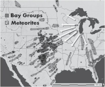
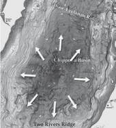
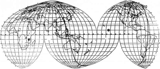
The first task was to identify where the cometary fragments hit Earth. To do so Firestone investigated 'secondary craters', i.e. the craters created by ejecta coming from the primary impacts. Interestingly, the orientation of the secondary craters pointed towards the same location.
By triangulating the trajectories followed by the ejecta (see pictures on the right for an illustration of the method applied to the Hudson impact), Firestone identified five potential primary impacts and their diameter:
- Hudson Bay, Canada: 300 miles (480 km) diameter
- Amundsen Bay, Canada 150 miles (241 km) diameter
- Baffin Island, Canada 75 miles (120 km) diameter
- Lake Michigan, United States 65 miles (105 km) diameter
- Lake Saimaa, Finland: 180 miles (290 km) diameter
The primary craters were, however, noticeably shallower than expected. The shallowness of the craters relative to their width and length suggests that the impactors were not solid rock (meteorites) but more likely 'dirty snowballs' (cometary material) and that their impact angle was low.
Indeed, the angle and the nature of the bolide has a direct influence on the shape of the crater. A rock solid meteorite following a vertical trajectory would create a round and deep crater while a 'fluffy' cometary fragment hitting Earth at a low angle would create a shallow elongated (elliptical) crater.
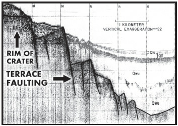
Firestone's hypothesis was confirmed by geological surveys. For example, in Lake Michigan it was revealed that the Chippewa basin looked like a typical crater sub-basin, with its 'terrace faulting', a stair-step pattern formed when large slabs of rock crack and slide downward after impact (see picture on the right).
The Chippewa basin also reveals some radial fracturing which is usually associated with extraterrestrial impacts.
In summary, Firestone's bombardment scenario goes as follow: a massive comet approached Earth and fragmented into bolides of various sizes. Five cometary fragments were particularly massive and reached the surface of the planet.
The 5 impacts happened virtually at the same time, which suggest they were all part of the same cometary swarm. The fact that the four first impacts in the list above hit a very narrow location (Northern America) suggests that the comet fragmented in 4 pieces shortly before impact.
The fifth crater located in Finland suggests that, before the final fragmentation, an earlier fragmentation occurred where the body that hit Finland freed itself from the rest of the cometary body.
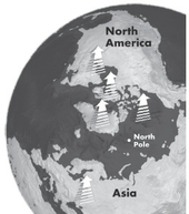
Analysis of the five primary craters showed that they had a similar orientation, therefore they probably came from the same place and belonged to the same cometary cluster (see picture left).
Firestone could only check crater sites on ground or under relatively shallow water. It's entirely possible that other massive cometary fragments hit the oceans, particularly in the vicinity of the 5 listed impacts (Arctic Ocean, northern Atlantic Ocean, Baltic Sea, etc). Such impacts would leave no trace but would be nonetheless very destructive, creating massive tidal swells, among other effects.
Firestone also managed to estimate the angle of the cometary fragments by analyzing the geometry of the craters. The rings at the bottom of the craters have the same elliptical shapes. To create such elongated elliptical craters, the impactors would had to have come in at a low angle, between 5 and 15 degrees above the horizon.
Now we know that the woolly mammoths were killed by cometary bombardments. But the main question remains unanswered: how did the mammoths get flash-frozen? First, let's define more precisely what flash-freezing is.
What is flash-freezing?
Flash-freezing is the sudden exposure of an item (food, biological sample) to cold temperatures in order to preserve it. American inventor Clarence Birdseye developed the quick-freezing process of food preservation in the 20th century.
This rapid freezing is usually done by submerging the sample in liquid nitrogen or a mixture of dry ice and ethanol. Liquids are usually used because their thermal conductivity is about 40 times greater than air.
There are many forms of flash-freezing from the mildest to the most sudden ones. So, what kind of flash-freezing was experienced by the woolly mammoths?
"At normal body temperatures, stomach acids and enzymes break down vegetable material within an hour. - What inhibited this process? The only plausible explanation is for the stomach to cool to about 40°F in ten hours or less. But because the stomach is protected inside a warm body (96.6°F for elephants), how cold must the outside air become to drop the stomach's temperature to 40°F? Experiments have shown that the outer layers of skin would have had to drop suddenly to at least -175°F!"The undigested food (grasses, mosses, shrubs and tree leaves, according to Russian scientist V.N. Sukachev) found in the stomachs and digestive tracts of the mammoths is not the only evidence of flash-freezing.
- Mark A. Krzos, Frozen Mammoths
According to several accounts, food was also found in the mouths of the frozen mammoths. This food, consisting mainly of buttercups, had been cropped but not chewed or swallowed. The buttercup froze so rapidly that it still had the imprints of the mammoths' molars. Despite its elasticity, the buttercup did not have time to revert back to its initial shape after the mammoth died.
For biology applications, the key idea of flash-freezing is to drop the temperature fast enough so that large ice crystals can not form and damage the cells that would otherwise burst or be punctured by the sharp-edge ice crystals that form.
This is exactly what was revealed to be the result of a detailed analysis of the cellular samples extracted from the woolly mammoths:
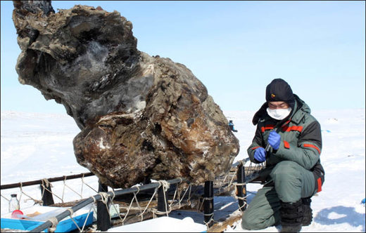
"The flesh of many of the animals found in the muck must have been very rapidly and deeply frozen, for its cells [had] not burst. Frozen-food experts have pointed out that to do this, starting with a healthy, live specimen, you would have to drop the temperature of the air surrounding it to a point well below minus 150 degrees Fahrenheit."In 2013, a female mammoth in pristine condition was found on the Lyakhovsky Islands in Siberia. Interestingly, when scientists poked at the mammoth's frozen remains with an ice pick, blood started to flow.
Ivan T. Sanderson, 'Riddle of the Frozen Giants', Saturday Evening Post, 16 January 1960, p. 82.
Given that blood starts to coagulate only a few minutes after death, this suggests that the woolly mammoths froze so quickly that their blood didn't have time to coagulate.
According to experts, for this sudden freezing to occur inside the warm body (96.6°F for elephants) of woolly mammoths who had a thick layer of fat and hair, they would had to have been subjected to extremely low temperatures: -175F (-115°C).
If we posit that temperatures in Siberia, which was under a temperate climate at the time, were around 60F, it means that the temperature dropped from +60F to -175, which is a 235F (130°C) temperature drop within a few hours.
Has such a severe drop in temperature ever occurred in recorded history?
Recorded cases of sudden cooling on our planet
First, let's check historical records to see if recent history ever witnessed such a severe cooling.
On 11/11/11 an exceptional thunderstorm located over the U.S. Midwest caused a drop of 69F (from 80 to 11) in 14 hours. This is the steepest recorded temperature drop. Yet this record drop in temperature pales in comparison to what happened to the mammoths both in terms of scope and temperature magnitude.
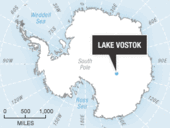
The current record low temperature is -89C (-128F), measured at Vostok station in Antarctica. In addition, Vostok is located close to the center of Antartica (South Pole), which experiences 6 month-long winter nights and subsequent freezing temperatures. This is not a temperate region like the one the mammoths inhabited.
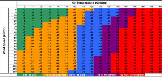
Notice that while -150F is required to flash-freeze a mammoth, a higher temperature could achieve the same result if sufficient wind was generated.
This phenomenon is called 'wind chill'. For example, an air temperature of -60C combined with 110 km/h (55mph) winds leads to a heat loss equivalent to -100C, i.e. the temperature required to flash-freeze mammoths and other animals (see wind chill table on the left).
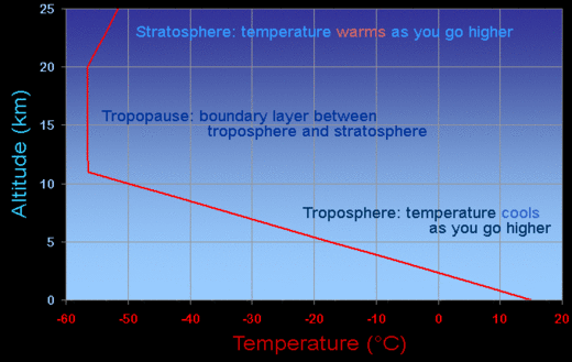
While -100C or even -60C cannot be found on Earth's surface, especially in temperate regions, this is a fairly common occurrence just a few miles above our heads. At 7 miles altitude, average temperatures vary between -50C and -80C. 7 miles altitude marks the area where the upper limit of the troposphere and the lower limit of the stratosphere meet. This boundary is called the 'tropopause'.
The problem is that the tropopause forms an almost unbreachable boundary. A very small number of documented events can trigger a breach of the tropopause: superderecho (super-storm), giant smoke clouds triggered by massive fires (pyrocumulo nimbus), and major volcanic eruptions.
However, such events are local and can't account for the flash-freezing of the whole Siberian region along with part of Alaska and the Yukon.
So what could have carried the freezing upper atmosphere air down onto a vast region of the planet? Comets and asteroids. While it seems counter-intuitive that the impact of a asteroid could cause massive cooling on the surface of our planet - after all, when entering the atmosphere, rocks heat up and, on reaching the surface of the planet, will spread fire and heat. That is true, but is it the whole story?
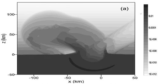
Until recently, asteroids were solely considered as the harbingers of fire and scorching heat. However, in 1983, a researcher came up with the concept of asteroid-induced atmospheric erosion.
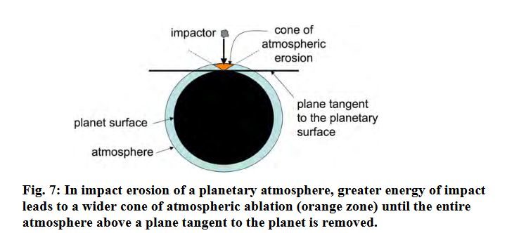
When large and fast enough, an asteroid can obliterate part of the Earth's atmosphere. On impact, the asteroid vaporizes (heat and pressure transform the asteroid into gases), as does a similar mass of the Earth's surface where the impact occurs.
The ensuing hot gas plume can expand faster than escape velocity, which is about 11.2 km/s on Earth. For comparison, the typical speed of asteroids in space is about 30 km/s. The escaping plume drives off the overlying air into space.
Specifically the part of the atmosphere that will be carried up into space along with the hot gas plume is shaped like a cone. It is known as the 'cone' of atmospheric erosion.The shape of this cone will depend on the size of the asteroid, its density, its speed and its angle relative to the Earth's surface.
To better understand atmospheric erosion, let's look at an analogous phenomenon that we are familiar with, called 'water backdrop'.
When you drop an object in water, you'll sometimes witness water moving upwards from the location were the object impacted the water. The water acts like a spring and recoils upwards. This recoil can take the form of a water plume and/or water drops.
In a similar way after the impact of an asteroid, matter and gases will move upwards because of the recoil effect boosted by the rising ambient heat.
But, unlike the water drop, it won't fall back down because the speed of the rising material exceeds escape velocity - the velocity required to escape the gravity of the planet - like a space rocket for example.
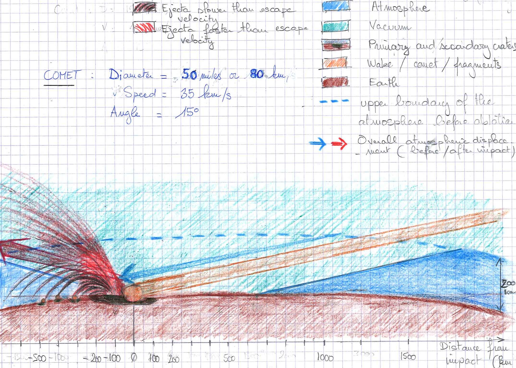
The drawing below is inspired from the work of Russian volcanologist V. Shuvalov, who calculated the effects of cometary/asteroid bombardments in terms of atmospheric erosion.
However, the cases Shuvalov studied are limited to bodies that are smaller and exhibit a greater impact angle than the cometary fragments that hit Hudson Bay 12,900 years ago. I've tried to apply Shuvalov's analysis to the Hudson object posited by Firestone:
The cometary fragment (orange ball) is estimated to be 50 miles (80 km) in diameter and entered the atmosphere from the North at a low angle (about 15°) as depicted by the orange line.
At impact, the cometary fragment created a substantial but shallow primary crater about 300 miles in diameter (black crater) and a massive plume (red in the drawing) that will, in turn, create debris-induced secondary craters (the Carolina Bays for example).
Notice the cone of atmospheric ablation, which is the turquoise area, below the blue dotted line (upper boundary of the atmosphere before ablation). The diameter of the cone at ground level is about 700 miles (1000 km). The non-ablated part of the atmosphere is the dark blue area visible on the left and on the right of the drawing.
Of course, one single drawing doesn't convey the magnitude of the forces and dynamics that are likely present during such an impact, so allow me to explain further:
- At first the atmosphere around the cometary body is accelerated through friction (see blue arrow along the orange wake), it is similar to the wind you feel when standing by a car that passes nearby.
- At impact, the powerful wind created along the wake combines with the massive stream of super-hot gases and vaporized material, part of it reaches escape velocity and flies out into space in a massive updraft (see red arrow in the drawing) carrying with it a large chunk of Earth's atmosphere (red ejecta). Meanwhile, the slowest ejecta falls back on Earth's surface (black and red ejecta).
- For a short period after the impact, the ablation zone is a void of space emptiness (turquoise area). For reference, the temperature of outer space is -270.5°C or -455F while the temperature of space near the Earth is 10.17°C or 50.3F.
- The vacuum is followed by a downdraft equally powerful to the updraft that preceded it. Super-cooled air violently refills the void.
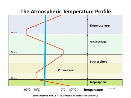
In the high atmosphere, the temperature is about -50C (-58F) on average (see vertical blue line in the diagram on the right), but can be as low as -90C (-130F) just above the mesopause.
The whole refilling process involves super-cooled air because the surrounding air when filling the vacuum will encounter a pressure drop.
In addition, with part of the atmosphere having been ablated, the atmosphere as a whole loses volume and ends up being thinner which leads to an overall atmospheric pressure drop (decrease in the height of the atmospheric column).
Depression does cool gases: you have an example when you use an air spray to clean your keyboard: while the pressure in the can drops, the air gets colder and colder.
When combined together, the three atmospheric features listed above: tornado-speed winds, cold air inflow from the upper atmosphere and super-cooling due to decompression may lead to truly unfathomable chill factors that could have easily flash-frozen the woolly mammoths and numerous other animals.
Now that we have an idea of how the woolly mammoths and friends got flash-frozen, the next question is, how did they remain frozen?
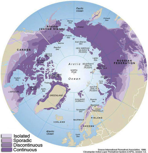
To remain frozen, they would have had to remain in an environment where temperatures stayed below 0°C (-32F). Aside from the ice sheets, such conditions on Earth occur only in permafrost, which is found in mountains at high altitude or at high latitude (60° or more).
But northern Siberia doesn't feature any high mountains and its latitude, at the time, was about 40° North. This means that Siberia experienced well above freezing temperatures most of the year.
To explain how the mammoths remained frozen for about 13,000 years, we must introduce the notion of wandering geographic poles (not the human kind).
Wandering Geographic Poles
It is commonly believed that the geographical pole has always been in the same present location. However, data proves that this is not the case. The location of the geographic pole has changed a lot, even in recent times.
Some of the best evidence that the geographic poles have changed location is coral. Reef coral require a minimum water temperature of 68°F. However geologic analysis reveal the presence of coral in some of today's coldest areas:
"In the Carboniferous formation we again meet with plant remains and beds of true coal in the Arctic regions. Lepidodendrons and calamites, together with large spreading ferns, are found at Spitzbergen, and at Bear Island in the extreme north of Eastern Siberia; while marine deposits of the same age contain an abundance of large stony corals." (435:202)For decades, Chinese oceanographer Ting Ying Ma studied coral and managed to establish the positions of the ancient corral-lines which more or less coincide with the equator line. Ma's coral-lines/equator lines run in all directions, one even crosses the Arctic Ocean. Some old coral is found very far from the current equatorial region. Ancient coral colonies have also been found in Ellesmere Island, within the Arctic Circle.
~ C. Hapgood, The Path to the Poles, p.159
Another way to know the past location of the geographic poles is called paleomagnetism. It is based on the analysis of the direction of iron particles in rocks like magnetite or hematite.
When these rocks form while solidifying from a liquid phase (volcanic eruption for example), the magnetized iron in the molten rocks act as compasses and solidify in a position that lines up with Earth's magnetic field.
Not only do these iron particles indicate the direction of North at some time in the past, but because of their vertical dip they also indicate how far away the pole is (i.e. the latitude). The closer to the pole the iron particle is, the less vertically tilted it will be.
One problem with this method is the fact that the magnetic pole also wanders. However, over a period of a few thousand years the magnetic pole returns to its original position, and the average position of the magnetic pole over the whole period coincides with the Earth's axis of rotation. Therefore for paleomagnetism to reliably reveal the position of the geographic pole, samples over a long enough period of time have to be collected. That's the reason why lava flows are so valuable. Eruption after eruption, they stack over each other while each lava flow indicates the location of the pole at the time on an eruption.
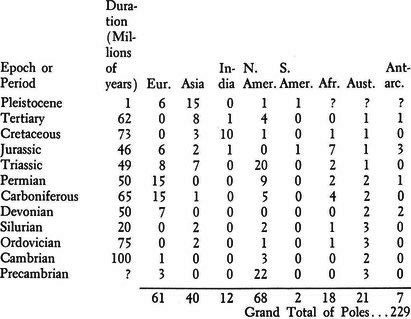
Charles Hapgood compiled the locations of the geographic poles over the ages and his results were unexpected. For example, during the Pleistocene - the epoch that lasted from about 2,588,000 years ago and ended with the Younger Dryas - the geographic pole occupied 15 different locations.
From the Precambrian epoch until now, (about 100 millions years), Hapgood identified a grand total of 229 different locations for the geographic pole.
Now that we know that the location of the geographic poles is not as fixed as once believed, let's try to determine where the geographic pole was located before the impacts in question.
Location of Geographic North Pole before Impact
Geology provides a robust method to determine the past location of ice caps and as a result, the past location of the geographic poles (the pole being roughly at the center of the ice cap).
Indeed, the edges of the ice cap are set in motion by the pressure of the ice behind them and start their scouring action, striating the bedrock of the continent over which the ice cap expanded.
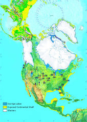
Geological studies indicate that during the last phase of the Pleistocene (17,000 to 13,000 BP), the Laurentide ice sheet was centered around Hudson Bay (see map on the right).
The Laurentide ice sheet represented most of the Northern ice cap which covered almost all of Canada, Greenland (except its coast) and a small fraction of Northern Europe. All the rest of the Northern hemisphere including the Arctic Ocean, Alaska, Siberia and part of the Yukon were ice free.
As noticed by Hapgood, the Laurentine ice sheet was similar both in size and shape to the present Arctic ice sheet:
"The first line of evidence that the last North American ice cap was a polar ice cap is based on the shape, size, and peculiar geographical location of the ice sheet. Two geologists, Kelly and Dachille, have pointed out that the area occupied by the ice was similar both in shape and size to the present Arctic Circle. Many others have remarked on its unnatural location. It seems to have occupied the northeastern rather than the northern half of the continent. No one has explained why the ice cap, which extended southward as far as Ohio, did not cover some of the northern islands of the Canadian Arctic Archipelago, islands lying between Hudson Bay and the pole or why it failed to cover the Yukon District of Canada or the northern part of Greenland. Later we shall examine a considerable amount of evidence indicating that the Arctic Ocean itself was warm during the ice age."The above strongly suggests that before the Younger Dryas, the North geographic pole was located around Hudson Bay, which is about 60° North - that is; 30 degrees in latitude away from the current North pole.
~ C. Hapgood, The Path to the Poles, P. 216
But the peculiar Laurentide ice sheet is not the only evidence we have. The study of fossils provides a very good idea of what kind of plants and animals lived in different locations of the planet right before the Younger Dryas. This research tends to confirm that, at the end of the Pleistocene, the North pole was located in Hudson Bay.
Indeed, before the Younger Dryas, the Arctic Ocean was a temperate ocean (as indicated by the presence of Foramainifera in sea cores), Siberia was a temperate region (as indicated by human remains, entire forests and temperate flora), and Japan was warmer than today (as indicated by flora that grows in temperate climate and by the corals of Okinawa).
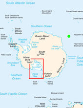
Another piece of evidence comes from Antarctica. A geographic North pole located around Hudson Bay would place the geographic South Pole about seven times farther away from the Ross Sea in Antarctica than it is now. Therefore, the Ross Sea should not have been glaciated at the end of the Pleistocene (c. 13,000BP).
This is exactly what sea cores revealed with layers of fine sediment typical of temperate climates. This fine sediment is carried by rivers from ice-free continents. Interestingly, if the North pole was located in Hudson prior to the Younger Dryas, it would explain two mysteries that have puzzled many experts.
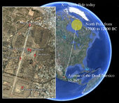
First, the awkward orientation of Stonehenge and Teotihuacan. The main axis of these two sites points roughly towards the North, but not exactly (Teotihuacan is 15° off while Stonehenge is about 40° off).
However both point directly towards Hudson Bay. One might wonder if Stonehenge and Teotihuacan were built prior to the Younger Dryas and aligned with the North-South axis of the time.
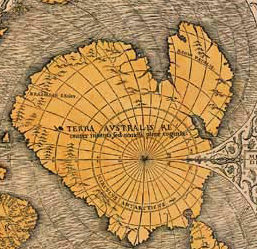
Second, the ancient maps which represent an ice-free Antartica. A group of ancient maps, called "maps of the ancient sea kings" was published in 1531 by the French geographer Oronce Fine, but the maps were far more ancient than 1531. Apparently they were drawn by some very ancient people then preserved by some past civilizations (Greeks, Phoenicians, etc), and finally discovered by Fine.
The truly astounding features of these maps is that they depict a completely non-glaciated Antarctic continent. Remember that at the time of the discovery (1531), Antarctica was not even known about.At first the maps were dismissed, but when scientists started to map the Antarctic continent they found that the ancient maps were too accurate to be the result of random chance:
"In several years of research, the projection of this ancient map was worked out. It was found to have been drawn on a sophisticated map projection, with the use of spherical trigonometry, and to be so scientific that over fifty locations on the Antarctic continent have been found to be located on it with an accuracy that was not attained by modern cartographic science until the nineteenth century."The above evidence strongly suggests that, about 13,000 years ago, the geographic North pole was located around Hudson Bay, which is about 60° N, or 30° away from the current North pole.
~ C. Hapgood, The Path to the Poles, p. 258
This would have placed Northern Siberia at 40° degrees of latitude North (the current longitude of Northern Siberia is 70°, to which we subtract 30°, giving us 40° N).
40°N is the current latitude of Spain, Greece, Italy, California and Nevada. It is a latitude typical of temperate climate. It is under this temperate latitude that the woolly mammoths lived, but it's not under this latitude that their corpses were preserved frozen.
The cometary bombardment had dramatic effects for our planet, including the location of its geographic poles. Now let's look at how it happened.
Crustal slippage
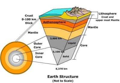
We consider our planet to be a solid piece of rock because all we see is its surface made of solid rock (mountains, deserts, ocean floors, etc). However, solid rock is only a tiny part of planet Earth, a thin layer (called 'crust' or 'lithosphere') that is less than 100 km (60 miles) thick.
Beyond the crust is the mantle, a thick layer of magma with an average thickness of 2,886 kilometres (1,793 miles). While the lower part of the mantle behaves like a solid because of the tremendous pressures that bind the molten material together, the upper mantle, also known as the asthenosphere, which is both hot and under relatively little pressure, exhibits a low viscosity and has the mechanical properties of a semi- fluid.
Those fluid properties are particularly present in a specific layer of the asthenosphere:
"It seems that such a layer has been discovered in the asthenosphere at a depth of about 100 miles. According to the Soviet geophysicist V. V. Beloussov, chemical processes at this depth, made possible by change of phase, are changing heavier into lighter rock, thus causing gravitational instability as the lighter rock tries to rise to the surface. Beloussov has named this the "wave-guide layer." Observations by the American geophysicist Frank Press are in general agreement. Press finds (from satellite observations) that this layer is a very liquid one. It seems that if the earth's outer shell does slide as a unit over the interior, this is the most likely level at which the movement can occur."So, from a mechanical perspective, the crust is relatively similar to an iceberg floating on the ocean (the low-viscosity asthenosphere). The low viscosity of the mantle explains why continents keep on drifting. It also suggests that it takes far less mechanical force to shift the crust relative to the mantle than to shift the whole planet.
~ Charles Hapgood, The Path to the Poles, p.119
Shifting the whole planet (crust, mantle and core) would require enormous forces. When one enters the data relative to the asteroids posited by Firestone (about 50 miles in diameter) in an asteroid impact simulator, the energy of Firestone's cometary fragment is way too low to have induced a change in the orbit, the spin rate or the tilt of the whole planet. Such an object could not budge our planet which, comparatively, carries way too much momentum.
For comparison, the estimated mass of Earth is about 6X1024 kg, while the mass of an 100-mile diameter asteroid is about 1.2X10¹⁸ kg. The Earth is therefore about 5 million times heavier than the cometary fragment.
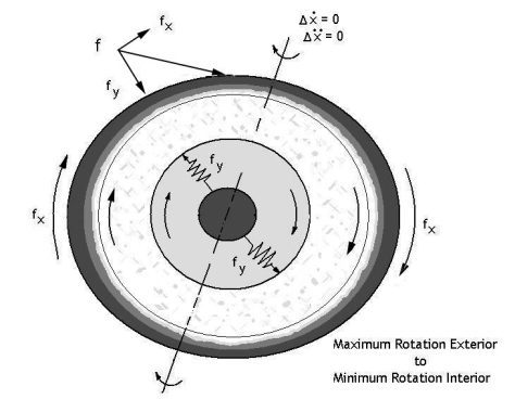
However, the low viscosity of the upper mantle might have allowed such impacts to slip the crust relative to the mantle, particularly if the incoming asteroids exhibited a low angle (i.e. close to being tangential relative to Earth's surface) which seems to be the case for the cometary fragments posited by Firestone. The picture on the right shows the physics around an asteroid-induced crustal slippage. The whole reasoning can be found here.
According to Charles Hapgood, the cometary bombardment slipped the crust by about 30° and the geographic poles moved to their current location. For Italian engineer Flavio Barbiero, the crust slipped by about 20° degrees.
Hapgood and Barbiero might be close to the truth. In any case, the slippage must have been greater than 20° in order to shift Siberia into the permafrost region (latitude greater than 60°N) and allow the mammoths to remain frozen.
At this point we have a good idea of how the mammoths may have been flash-frozen and how they remained frozen (crustal slippage moving the North pole closer to Siberia). However, the corpses of the mammoths revealed several other puzzling pieces of evidence.
The Coroner's Verdict
Since 1800, at least 11 scientific expeditions have excavated frozen mammoths. Most of them were found in Northern Siberia along with other mammals: ox, wolverine, voles, squirrels, bison, rabbit and lynx.
The Berezovka Mammoth is probably the most famous one. It was found frozen along the Berezovka river (hence its name) in a near-perfect state of preservation.
Only part of his trunk and his head had to be reconstructed because they were not embedded in ice and were consequently eaten by predators.
It is displayed in the Zoological Museum in St. Petersburg, Russia, in the struggling position in which he was found near the Berezovka River, just inside the Arctic Circle.
The pristine state of the frozen mammoths allowed scientists to extract a lot of information about the mammoths per se and about their cause of death.
Actually, the mammoths are so well-preserved that some scientists are attempting to use mammoth DNA in order splice it with Asian elephants to reintroduce the extinct woolly mammoth.
Coroners who examined many mammoths found the same features in a number of them:
- fractures: the Berezovka mammoth had numerous broken bones including several ribs, shoulder blade and pelvis.
- dirt: found in the lungs and digestive tracks of the frozen mammoths. It should be noted that the only cause of death that could be definitely established was suffocation. At least three mammoths and two rhinoceroses suffocated. No other cause of death has been established for the remaining woolly mammoths. Vollosovitch concluded that his second buried mammoth, found with a penile erection on Bolshoi Lyakhov Island, had suffocated. One mammoth named Dima was found to have pulmonary edema, suggesting death by asphyxia after great exertion just before death. The Pallas rhinoceros also showed symptoms of asphyxiation.
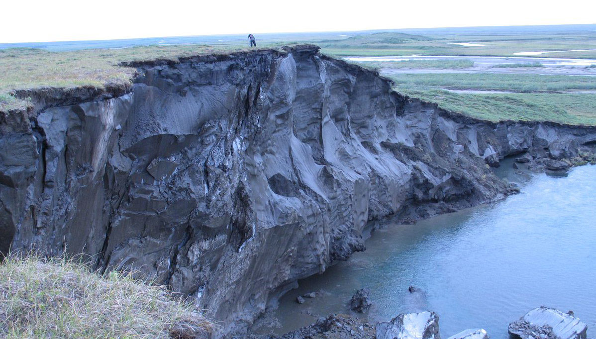
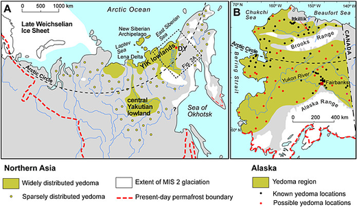
- Yedomas: these are mounts (30 to 260 feet tall) made of soil mixed with thick veins of ice. Yedoma is widespread in Siberia (Fig. 1), where the total area of its occurrence is about 1 million km2. Yedomas are very rich in carbon and they are literally filled with dead trees and dead animals. For example the 'mammoth cemetery' is a yedoma containing the corpses of not less than 156 mammoths. The soil constituting the yedomas is called 'loess', which is basically wind-blown silt (i.e. eolian sediment).
- Upright position: 112 mammoths, including the Berevoska one, were found in an upright position.
Each location experienced its own variation on the disaster theme. Describing each combination of effects experienced in each part of the globe would be too tedious and, after all, our main topic is the woolly mammoths. So in the following timeline we will focus on the sequence of events that occurred in Siberia and led to the demise of the woolly mammoths.
The Tragic Fate of the Woolly Mammoths
As indicated by the discovery of the ripe fruits of sedge, grasses, and other plants in the stomach of mammoths, the action takes place in the middle of summer, in a temperate and lush northern Siberia forest, about 12,900 years ago.
First, a new star appeared in the night sky, then it grew in magnitude. It became visible in daytime and eventually it outshone the sun, both in brightness and size.
A few minutes before impact, the 'second Sun' separated into at least 5 majors parts and many minor ones which crossed the sky above Siberia and followed their trajectory towards the North before disappearing beyond the horizon (traveling at about 35 km/s).
The sky was streaked with the fiery wakes of thousands of small fragments that disintegrated in the atmosphere. A sudden wind triggered by the wake of the major cometary fragments started to blow up dirt from the ground and shake the surrounding trees.
Powered by the air depressions created by the wakes, the wind grew in force, the air became filled with dust, the mammoths braced themselves against the wind as they raised their heads and opened their mouth, gasping for some dust-free air.
The impact itself lit up the Northern horizon, the prolonged flash of light was blinding. The updraft plume threw a massive chunk of heated atmosphere into space. The pressure dropped suddenly, bringing down the atmospheric temperature and for a few seconds the mammoths were exposed to the glacial void of space, and the flash-freezing began. Some mammoths died at this point from suffocation.
This freezing in a vacuum might explain a very peculiar 'oxygen free' ice that was found underneath the frozen mammoths:
"Deeper down in the cliff the ice becomes more solid and transparent, in some places entirely white and brittle. After remaining exposed to the air even for a short time this ice again assumes a yellowish-brown color and then looks like the old ice.Then hurricane force winds started blowing super-cooled air toward the impact zone to refill the vacuum. This supernatural freezing wind lasted for hours. If the cone of ablation was 400 km in radius, hurricane force winds (200 km/h) would blow for two hours to refill the void. It froze the mammoths and many other creatures to the core.
Obviously, something in the air (probably oxygen) reacted chemically with something in the ice. Why was air (primarily oxygen and nitrogen) not already dissolved in the ice? Just as liquid water dissolves table salt, sugar, and many other solids, water also dissolves gases in contact with it. For example, virtually all water and ice on Earth are nearly saturated with air. Had air been dissolved in Herz's rock ice before it suddenly turned yellowish-brown, the chemical reaction would have already occurred."
Mark A. Krzos, Frozen Mammoths
While some mammoths remained frozen to the ground in their upright position, others were blown away and/or bombarded with flying/drifting debris (trees, boulders), this might explain the numerous broken bones found during the autopsies.
Along with this freezing wave, Siberia was inundated with unprecedented rainfall. The two main ingredients for precipitation are cooling and dust. The cooling leads to condensation (atmospheric water vapor transforming into liquid water) and the atmospheric dust acts as nucleation agents around which rain droplets form.
The magnitude of the cooling and the quantity of atmospheric dirt-saturated air led to torrential rainfall. In Siberia, where the cooling was most severe, it would have been an even more severe deluge of hail and snow.
Because of the quantity of dust, soot, dirt and sediment in the atmosphere, the falling hail and snow were very dirty and dumped on Siberia exceptional quantities of frozen water, soot and sediment.
The sheets of dirty rain, hail and snow would have stopped after a few days once atmospheric dust and water vapor were removed from the atmosphere by precipitation, but it continued because atmospheric dust and water kept being supplied by the ongoing ground and underwater volcanic eruptions triggered by the impact and the crustal slippage.
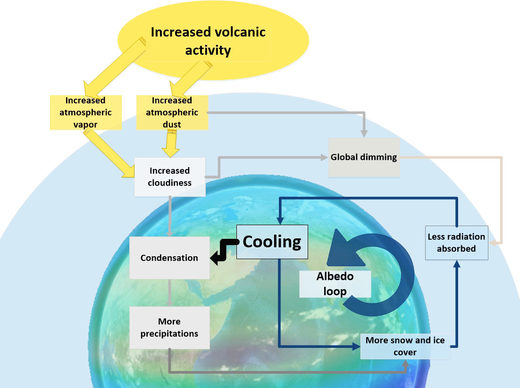
On top of this, the cooling was sustained and even worsened by an "albedo loop" where an increasing part of the planet's surface was covered with snow and ice which reflected more and more of the little sunlight that managed to penetrate the dusty atmosphere, which led to further cooling that created more ice and snow.
The diagram on the right describes the albedo loop and how sustained volcanic activity powered and worsened the whole dynamic.
In the above we have used mainstream concepts (dust, rain condensation, cooling) to explain the weather effects of the bombardment. However, electricity also plays a major role, particularly when atmospheric dust is involved.
The role played by electricity in weather phenomena has been thoroughly covered in our book Earth Changes and the Human-Cosmic Connection. Below is a very quick summary of the influence of electric charges and atmospheric dust on precipitation.
In fair weather conditions, electrons on the surface of Earth are attracted by the positively charged ionosphere. If there is dust in the atmosphere, the free circulation of electrons is hindered and electrons are captured by the atmospheric dust, creating negatively charged areas in the atmosphere.
Those local atmospheric electric charges are what ultimately power hurricanes with their associated precipitation and lightning, which are charge-balancing phenomena that bring electrons back to the Earth's surface. In addition, electric charges catalyze the accretion of water droplets.
The event generated numerous and massive sources of atmospheric dust (impacts, volcanic eruptions, giant forest fires triggered by the plume and the ejecta, and tornado-speed winds). In addition, the atmospheric dust coming from the cometary fragments was very positively charged.
The positively charged cometary fragments themselves disrupted the atmospheric electrical field (between the Earth's surface and the ionosphere), which is the driver of chaotic weather.
Under relatively normal conditions, precipitation can be more than 70 inches (almost 2 meters) over 24 hours, so we can start to imagine the kind of precipitation induced by the unique combination of factors listed above (dust-saturated atmosphere, electrically charged dust and disrupted atmospheric electrical field)
Precipitation carried tons of atmospheric dust down to earth and might well be the cause for the yedomas, which are basically an accumulation of wind-blown sediment and frozen water.
This layer of wind-blown sediment must have covered many parts of the northern hemisphere. But it is today only found in parts of Siberia and Alaska because those regions are covered by permafrost that held the ice complex/yedoma together and prevented water erosion (rain and rivers) from washing it away into the oceans.
It was a truly apocalyptic scenario that is difficult to fathom. Perhaps the closest comparison would be a months-long glacial giant hurricane generating incredible winds, mountains of dirty hail and snow, flying trees and animals, rolling boulders with never-ending volcanic eruptions and earthquakes in the background.
Tsunamis were, of course, also part of the picture. At the time, however, the sea level was 80 meters lower than it is today. So evidence for tsunamis is scarce.
The Hudson impactor must have been a major cause for tsunamis. It directly hit the 2-mile thick ice cap and projected thousands of cubic miles of ice onto the Atlantic Ocean. This massive amount of ice released into the ocean is accounted for by the 6 meter rise in ocean level.
"Reconstruction of the glacial melt history finds major northward melt-water discharge 13,100-12,500 years ago, at the beginning of the Younger Dryas. The outflow entered the Arctic Ocean, via the Mackenzie River, Fram Strait, and ultimately reached the eastern North Atlantic.'When contemplating the catastrophe described above, one can't help but be reminded of the 'mythical' Great Deluge, the 40 days of rain that faced Noah and which wiped out most of humanity, according to the Bible.
Geomorphological data, on the other hand, suggest that still blocked routes to the north and east toward the St. Lawrence Seaway until the end of the Younger Dryas. Sea level curves from Tahiti, New Guinea, and Barbados show a small step (under 6 meters) around 13,000 years ago near the Younger Dryas onset, which may have come from this deluge."
~ Vivien Gornitz, Rising Seas: Past, Present, Future, p.127
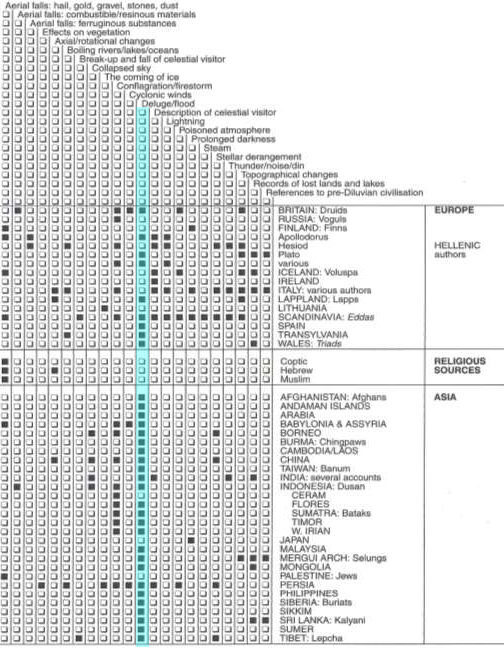
Actually, the Bible is far from being the only tradition that tells of a great deluge. In 500 cultures spanning all continents, researcher Douglas Eddinger found that about 90% of them included an account of a great deluge.Conclusion
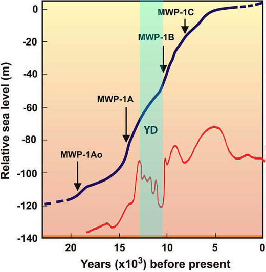
While researching the topic of the frozen mammoths, I discovered an unexpected anomaly. The Younger Dryas was a 1,400-year global cooling period (see red curve on the right) which led to an increase in the size of ice sheets. However, during the same time period (13,000 BP-11,500 BP), sea levels rose by about 20 meters (from -70 to -50m as shown in the chart on the right).
Cooling usually means an increase in ice sheet size, which leads to a drop in sea level (the sea water being transformed into ice). Yet during the Younger Dryas, the exact opposite happened.
Where did all this extra water come from?
One possibility is an extraterrestrial inflow: planet Mars might have been closer than usual to planet Earth at the time, and through electrogravitaion, Earth might have 'stolen' water that is today said to be 'missing' from Mars.
That would explain the sudden rise of sea levels on Earth (despite the Younger Dryas cooling) and the fact that nowadays Mars is a dry planet despite plenty of evidence showing that in the past it had vast water systems. But there are enough outlandish claims in this article already (cometary bombardments, atmosphere ablation, flash-freezing, crustal slippage) without delving into another rather controversial topic.
Whether Earth interacted with Mars or not, it is clear that the Younger Dryas period was marked by serious catastrophes. The woolly mammoths and the Clovis people were the tragic witnesses to a major cosmic event that deeply transformed our planet about 13,000 years ago.
This event is a serious thorn in the side of uniformitarians who, despite copious evidence, still deny the facts before them. The insistence on clinging to a uniformitarian dogma that has proven to be false can be found in the very foundation of politics and power, as mentioned in ECHCC:
"The legitimacy of the ruling class - in whatever political form it may take - is based on the illusion that they can protect the people, whether from war, famine, economic hardship, or any other kind of disaster that disrupts the everyday routine of their lives and livelihood. ...If even a smaller version of the Younger Dryas cometary bombardment happens during our time, I would be curious to see how the elites react, if indeed they survive to react at all. Will they acknowledge the fragile human condition and their total powerlessness in the face of cosmic forces? Or will they try to parlay the cosmically-induced event into a human-made catastrophe, as they are currently doing with global warming and climate change?
By attributing the cause of these cosmically-induced events to humans, the elites maintain the illusion that they are, at least to some degree, in control; if they are causing it, then theoretically, at least, they could stop it."
P. Lescaudron & L. Knight Jadczyk, Earth Changes and the Human-Cosmic Connection
The 'Russia did it' meme has been working so well for Western power-brokers lately that the temptation to use it in such a critical context might prove too much for them. I can almost see the CNN headline: 'Mad, Bad Vlad, already the source of all trouble on the globe, pressed the button and made it explode'.







Comment: The follow-up of this article is titled: "Did Earth 'Steal' Martian Water". It is available here