Storms
S

Tornado1

Otto sets new record as latest hurricane to form in Caribbean

Hurricane Otto satellite
© CNN weather
The 2016 Atlantic hurricane season threw a late season curveball Tuesday: Hurricane Otto off the coast of Central America.

The rare late-season storm strengthened from a tropical storm after it spent much of the afternoon stalled over warm Caribbean waters. In Panama, the storm was blamed for three deaths, including a child, after triggering a landslide and downing tree branches.

National Hurricane Center forecasters said late Tuesday afternoon the storm was located about 375 miles east of Costa Rica with sustained winds of 75 mph and moving west about 2 mph.

Otto sets a new record for the latest hurricane to ever form in the Caribbean, forecasters said, breaking a record set by Hurricane Martha in 1969 by a day.

A hurricane watch and tropical storm watches and warnings were issued up and down the Central American coast, from Nicaragua to Costa Rica.

Otto is expected to strengthen and pick up speed as it approaches the coast on Thursday. Forecasters warn the storm could dump up to 12 inches of rain, with higher totals between 15 and 20 inches in some locations. Life-threatening rip currents could also slam the coast over the next few days.

Comment: If Otto does reach Costa Rica, it will be that country's first hurricane landfall in recorded history (since 1851).


Tornado2

Hurricane Otto to threaten Central America on Thanksgiving

Hurricane Otto storm track
Otto strengthened into a hurricane Tuesday, killing three people in Panama and prompting hurricane watches for Nicaragua and Costa Rica, as it spun closer to a Thanksgiving Day landfall in Central America.

In Panama, rains and mudslides blamed on the storm killed at least three people, the Associated Press reported. Meanwhile, Costa Rica ordered the evacuation of 4,000 people from its Caribbean coast.

As of 4 p.m. ET, Otto was maintaining 75 mph winds, making it a Category 1 hurricane. It was located about 235 miles east of Limon, Costa Rica, and moving west at 2 mph, the National Hurricane Center said. The storm, which is the seventh hurricane of the 2016 Atlantic hurricane season, is expected to speed up Wednesday.

Total rainfall of 6 to 12 inches, with isolated amounts of 15 to 20 inches, are forecast across northern Costa Rica and southern Nicaragua through Thursday, and will likely result in life-threatening flash floods and mudslides, the hurricane center said.

Cloud Lightning

Lightning bolt kills boy and injures 4 others in Zimbabwe

lightning
A lightning bolt killed a 10-year-old boy and injured his three friends and a teacher in Binga last week. The boy and his friends were playing under a tree when it started raining in Tinde Village. Chief police spokesperson Senior Assistant Commissioner Charity Charamba confirmed the incident. "The boy was playing with three friends under a tree when it started raining. The boys were then struck by lightning including a teacher who was passing by and they all sustained injuries. They were ferried to hospital, where the boy was pronounced dead on arrival," she said.

Snr Asst Comm Charamba said the other three boys and the teacher were treated and discharged. "With the onset of the rainy season, members of the public are urged to take precautionary measures when it is about to rain, during or after.

"Please avoid taking shelter at isolated places or being the sole target at open spaces; avoiding contact with electrical gadgets and seeking shelter under isolated tall trees or other objects," said Snr Asst Comm Charamba.

Cloud Precipitation

Storm Angus: Flooding strikes south-west England

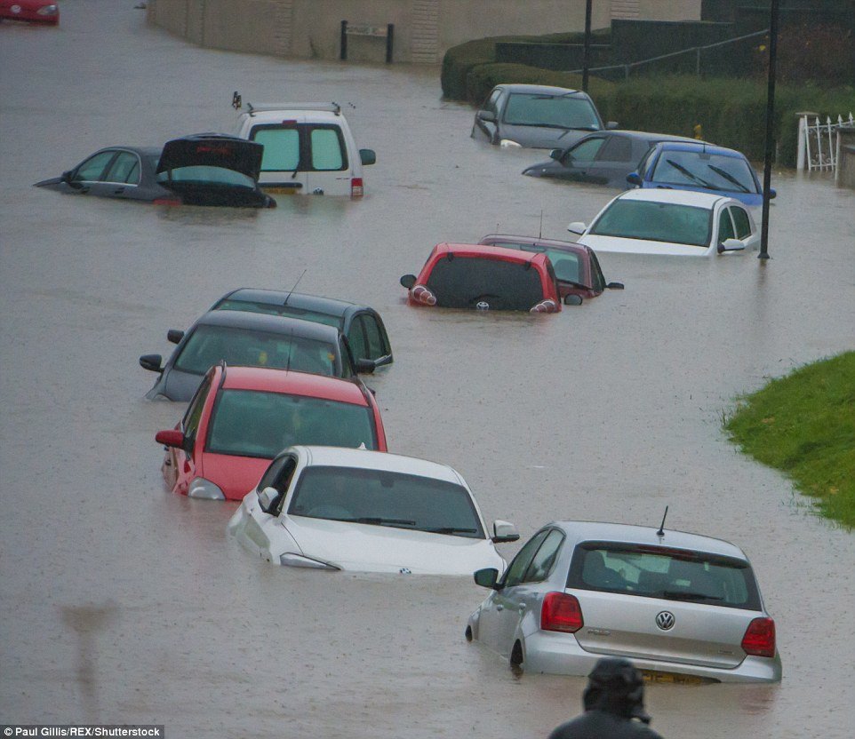
The flooded Whitchurch Lane in Bristol, pictured, was hit with more heavy rain during the course of the day
A swath of south-west Britain is coping with flooding and high winds as another block of torrential rain swept into Britain on the heels of Storm Angus.

The Met Office issued an amber warning - the second highest severe weather alert - for Devon and parts of Somerset, predicting that up to 30mm of rain could fall within an hour. It also released a yellow "be aware" warning for areas of northern England.

By early afternoon on Monday, there were 15 flood warnings - meaning flooding is expected and immediate action is required - in Devon, Somerset and Dorset. In addition, there were 89 flood alerts (flooding is possible, be prepared) across England and Wales.

Impacts were likely to include flooding of properties and parts of communities, the Met Office said, and significant disruption to travel, with a number of roads and rail services likely to be affected.

The Environment Agency said: "Across England and Wales localised impacts from river or surface water flooding are possible. Gales and large waves will affect the east Channel coast for a time overnight, giving the potential for soma localised spray and wave overtopping here."


Snowflake Cold

Officials declare 'yellow alert' for severe cold weather in China

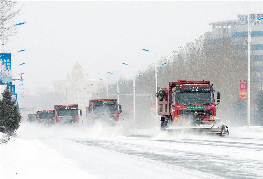
Snowplows clear a main road in Mudanjiang City in northeastern Heilongjiang Province yesterday. Heavy snow fall since Friday has closed several expressways in the province.
© Xinhua Snowplows clear a main road in Mudanjiang City in northeastern Heilongjiang Province yesterday. Heavy snow fall since Friday has closed several expressways in the province.
China's national observatory yesterday issued a yellow alert for a cold front that is forecast to sweep central and eastern China.

From today until Thursday, temperatures in most of the central and eastern part of the country are expected to drop by 6 to 10 degrees Celsius, said the National Meteorological Center.

In some parts of Henan, Anhui, Hubei and Hunan provinces, the temperature will drop by up to 16 degrees, said the NMC.

Yellow is the second-most severe level on China's four-level color weather alert scheme.


The cold front will be accompanied by gales, rain and snow.

Meanwhile, under the influence of a strong cold spell, parts of Beijing have been hit by snowfall since early yesterday.

Much of the capital city has been hit with snow after 8pm yesterday.


Cloud Precipitation

Flood warnings after UK battered by Storm Angus

Storm Angus hits UK
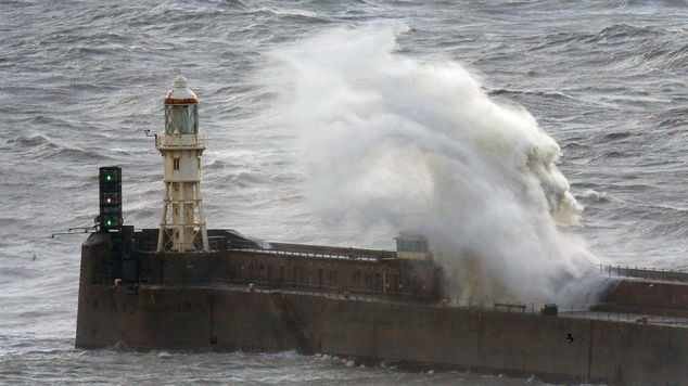
Waves crash over the harbour wall in Dover, Kent, as Storm Angus hit the UK with gusts anticipated to reach up to 80mph.
Heavy rain will see parts of Britain already battered by Storm Angus at risk of further flooding in the next 24 hours.

Wet weather is expected to sweep across the south west and move north, causing damage and disruption as it falls on already saturated ground.

The Environment Agency said it is preparing to put up temporary defences "where necessary" and said rivers have been cleared to make sure water can flow freely.

Motorists are being warned not to drive through flood water and residents in at-risk areas have been advised to contact their local councils for sandbags to protect their homes.

An amber "be prepared" warning has been issued for Devon, where the worst of the rain is expected to hit in the early hours of Monday.

Exeter had already faced more than two inches (54mm) of rainfall overnight into Sunday - more than half of what is usually expected in the area for the entire month of November.

The West Midlands, Wales and north of England are all covered by a yellow "be aware" warning, with more than two inches (60mm) of rain forecast to fall in some places.

Alison Baptiste, national flood duty manager at the Environment Agency, said: " Large parts of southern England have already experienced the impacts of Storm Angus this weekend.

Comment: Last week tornado-like winds whipped through western Britain.


Chalkboard

Mathematician claims one in 500 chance of extinction next year

Earth
© NASAThe calculation is based on the Doomsday Argument.
The human race faces a one in 500 chance of extinction in the next year, an expert mathematician has claimed.

Dr Fergus Simpson, a mathematician at the University of Barcelona's Institute of Cosmos Sciences, said there was a 0.2 per cent chance of a "global catastrophe" occurring in any given year over the course of the 21st Century.

The calculation is based on the Doomsday Argument, which it is claimed can predict the number of future members of the human species given an estimate of the total number of humans born so far.

"Our key conclusion is that the annual risk of global catastrophe currently exceeds 0.2 per cent," Dr Simpson wrote in an academic paper called Apocalypse Now? Reviving the Doomsday Argument, accessed through Cornell University's online library.

"In a year when Leicester City FC were crowned Premier League champions, we are reminded that events of this rarity can prove challenging to anticipate, yet they should not be ignored," he added.

According to Dr Simpson's calculations, around 100 billion people have already been born and a similar number will be born in the future before the human race expires.

He estimated there was a 13 per cent chance humanity would fail to see out the 21st Century.

This is a more optimistic conclusion than previous studies, with British Astronomer Royal Sir Martin Rees suggesting there was a 50 per cent probability of human extinction by the year 2100 in his 2003 book Our Final Hour.
Ice Cube

Heavy snow, blizzard conditions snarl traffic across midwestern U.S.

While the blizzard has come to an end, lake-effect snow and squalls will continue to develop over the Great Lakes this weekend. For more information, please visit this news story. High winds, heavy snow and localized blizzard conditions caused travel chaos across the midwestern United States late this past week.

After dumping over a foot of snow across the northern and central Rockies on Thursday, a storm with heavy snow and high winds shifted into the Midwest on Friday. The heaviest snow fell from Nebraska and South Dakota to portions of Minnesota and Ontario, where snowfall totals ranged from several inches to nearly a foot. Nearly 14 inches of snow was reported in Cass County, Minnesota.
Storm map
© AccuWeather
There was a sharp variation in snowfall on the northern and southern fringes, where a few miles meant the difference between a couple of inches of snow and more than half a foot. Blizzard conditions unfolded across these areas as wind gusts in excess of 50 mph howled from the north and northwest. The combination of heavy snow and high winds led to blowing and drifting snow, near-zero visibility and extremely dangerous travel along area roadways.

The first flakes of the season in Denver resulted in a deadly 20-car pileup along Interstate 70 near Evergreen, just outside of Denver. Parts of the highway were closed at multiple times throughout the evening. As many as 340 crashes and 550 spinouts were reported on Minnesota roadways on Friday, according to the Minnesota State Patrol. Two people were killed and another 37 were injured.

Cloud Lightning

Close lightning strike filmed in Mutare, Zimbabwe

Close lightning strike with slow motion
© Peter LowensteinClose lightning strike with slow motion
CAUTION! At full volume the bass on slow motion replay is very loud and could damage sub-woofers.

On 14 November there was a violent afternoon thunderstorm with hail and 90 millimeters of torrential rain which persisted into the night. At about quarter past three there was a very close lightning bolt which struck a pole which had just one week earlier been installed by the national telephone company to bring a fiber internet connection to my home. The pole is situated on the opposite side of the road less than 50 meters from the front of the house.

The accompanying video, which begins at normal speed then plays in three slow-mo rates of x0.5, x0.25 and x0.125 and ends at normal speed again, shows the brief but intense lightning flash descending towards the pole which is just below the field of view. It was accompanied by a sharp click of static electricity and almost immediately afterwards by a very loud report which could be felt and shook the house. This was followed by a deep rumbling sound which persisted for almost twenty seconds. An electromagnetic pulse was generated which was strong enough to affect the electronics in the Panasonic Lumix DMC-TZ10 being used to film the storm and produced strange bright histogram shaped patterns in the two frames which captured the strike. The video thumbnail image has been processed to remove these.

The fiber optic internet connection was unaffected by the strike but induced high voltages damaged the LNB in my rooftop satellite TV dish and connected decoder.


Windsock

Tornado-like winds whip through western Britain

Aberystwyth storm damage
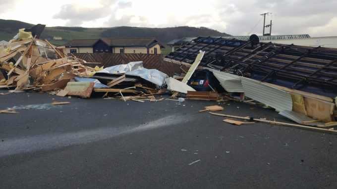
© Thomas Scarrott /PA WireAberystwyth (pictured) has been one of the worst affected areas by Thursday's stormy weather.
A combination of unstable upper air, heavy downpours and strong gusty winds peaking at 84mph (in Shropshire) earlier produced 'tornadic' winds across Wales and the West Midlands earlier this afternoon.

Reports of actual tornadoes remain unconfirmed by the Met Office and tornado and storm organisation TORRO.

Tornadoes or tornadic winds occur when we have particularly squally (or windy and wet) conditions, where strong wind sheer at the ground meets a strong updraft (due to unstable air and downpours) shooting up into the atmosphere.

The winds then become a powerful, destructive rotating column of air - extending skyward while maintaining contact with the ground.

The UK is no stranger to tornadoes - around 30 are reported every year - but don't always affect populated, urban areas.

A tornado swept through London in December 2006 damaging at least 100 properties and one of the strongest tornadoes on record ripped through Birmingham in summer 2005, where winds peaked at 130mph or more.