Storms
S


Tornado2

Waterspout filmed near Ludington, Michigan

waterspout
A funnel cloud spotted over on the west side of the state Tuesday in Ludington. It formed over the city as a form of hail and strong winds swept through the area.

Someone captured video of the funnel cloud outside the junior high and high school.

The National Weather Service in Grand Rapids confirmed the sighting of the funnel cloud in a Facebook post.

The National Weather Service explained it started as a water spout over Lake Michigan, underneath a developing shower which grew tall enough to form graupel.

"Waterspouts dissipate fairly quickly after reaching shore, but the funnel cloud can persist and any remnant ground circulation could produce a wind gust over 50 mph before diminishing," the National Weather Service wrote.

Graupel is granular snow pellets, and also sometimes called soft hail. The National Weather Service confirmed you can see graupel in the video as well.


Cloud Precipitation

Typhoon Saola brings record rainfall to Kyushu in Japan; 400 mms (nearly 16 inches) in 24 hours

People are seen outside JR Nagoya Station on Sunday afternoon
Typhoon Saola traveled along the Pacific coast of Japan's main island of Honshu on Sunday after bringing record rainfall to Kyushu, with the weather agency saying the typhoon will next dump heavy rain in the Hokuriku region on the Sea of Japan.

The season's 22nd typhoon was moving 170 kilometers west of Miyake Island in central Japan as of 6 p.m. Sunday, with an atmospheric pressure of 975 hectopascals, it was heading north-northeast with winds of up to 162 km per hour.

In Kyushu's Miyazaki Prefecture, more than 400 millimeters of rain was recorded in the 24 hours to Sunday morning, a record in the region.

The Japan Meteorological Agency warned the public to expect high winds, flooding of rivers and mudslides in wide areas of Honshu. The typhoon is expected to become an extratropical cyclone by Monday morning.


Cloud Lightning

Huge lightning bolt filmed striking a hotel balcony in Gladstone, Australia

The lightning strike caused sparks to fly only centimetres from an outdoor table on the balcony
This is the terrifying moment lightning struck centimetres from a hotel balcony.

Terror came to Tim Allfrey and his young family as they stayed at the Oaks Grand in Gladstone.

The Newcastle man captured the bolt on his camera phone as storms and heavy rain swept across central Queensland on Monday night.

Less than 30 seconds earlier, he was shooting panoramic footage of the regional city showing the bleak, grey night skies momentarily flashing pink as lightning was striking on the horizon.

Then, a white bolt of lightning causes sparks to fly centimetres from an outdoor table on the balcony.


Cloud Precipitation

Butter shortages, Black Death in Madagascar and massive hail

shelves
Worst butter shortages since world war two in France, along with lowest wine production since the same era. Massive winds and hail pummel Europe and Argentina, Arctic vortex in both Europe and USA and now the Black death is back in Madagascar, and India needs to pas laws not to kill witches. Oh my, we just entered the Twilight Zone.


Sources

Cloud Lightning

Lightning bolt kills three in Sri Lanka

LIGHTNING
Three people were killed when they were struck by lightning at Medamulana in Weeraketiya today.

Police said the victims aged between 30 and 60 years, residents of Galpottha had been struck by lightning when they were drying the paddy in an open area.

Attention

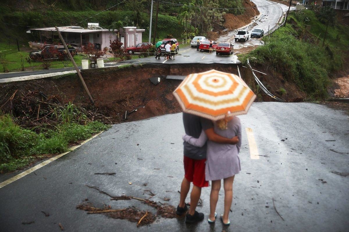
Puerto Rico power outage after Hurricane Maria largest in U.S. history

Puerto Rica hurricane damage
© Joe Raedle/Getty ImagesPuerto Rico's governor said about 95% of Puerto Rico's power could be restored by mid-December.
It has been 36 days since Category 4 Hurricane Maria made landfall on Puerto Rico with maximum sustained winds of 155 mph, and about 75 percent of the island's 3.4 million residents are still without electricity, with tens of thousands more still in the dark in the U.S. Virgin Islands.

Based on the duration and the number of people affected, this is the largest blackout in U.S. history, the economic research firm Rhodium Group (RHG) reported Thursday.

Maria was the strongest Puerto Rico hurricane landfall since the Category 5 September 1928 San Felipe/Lake Okeechobee hurricane.

A wind gust to 137 mph was measured in Isla Culebrita, Puerto Rico, while San Juan clocked a 95-mph gust at Luis Muñoz Marin International Airport.

Prior to both Irma and Maria, only four other Category 4 hurricanes tracked within 75 miles of central Puerto Rico in historical records dating to the late 19th century. Hurricane Hugo in 1989 was the last to do that prior to 2017, though it had weakened to a Category 3 hurricane as it clipped the northeastern tip of Puerto Rico, according to the NOAA best tracks database.

There were already 61,000 customers without power in Puerto Rico due to Irma the day before Maria made landfall on Sept. 20, according to RHG. A customer is defined as a household or business, not an individual.

Comment: Puerto Rico Gov. Ricardo Rosselló said about 95% the island's power could be restored by December 15. Whitefish Energy - a firm with ties to the Trump administration - was awarded a $300 million contract to help repair the island's electrical grid, which is raising some eyebrows on Capitol Hill over its transparency..

See also: Puerto Rico: 'Disaster capitalism', privatization on the rise


Cloud Precipitation

Unusually severe storm knocks out power for 1.2 million across New England (UPDATE)

Storm leaves thousands without power in Southern New England
A severe storm packing hurricane force wind gusts and soaking rain swept through the Northeast early Monday, knocking out power for more than a million and forcing hundreds of schools to close in New England.

Falling trees knocked down power lines across the region, and some utility companies warned customers that power could be out for a few days.

There were numerous reports of trees down on homes, roads and cars. Amtrak was forced to suspend service from Boston to Connecticut and the MBTA reported delays on several of its lines due to downed trees.

Winds are expected to remain strong Monday afternoon, which could slow the effort to restore power.


Comment:

Update (Tuesday Oct. 31)

More than 1.1 million power customers are still without electricity, say reports, including 248,557 in Massachusetts and 137,900 in Rhode Island. In Maine, which was especially hard hit, Gov. Paul LePage declared a state of emergency to give power companies more flexibility to make repairs.

At the height of the storm more than 450k lost power in the 4th largest power outage in New Hampshire history. Utilities have warned that power could be out for days. Temperatures in the region are due to fall to near freezing tonight says the National Weather Service.

There have been 214 reports of wind damage in the 24-hour period ending at 9:30 a.m. EDT Monday, primarily in New England, but also in the Hudson Valley, northern New Jersey and northeast Pennsylvania.


Heavy rain triggered both flash flooding and river flooding. The NWS office in Gray, Maine, warned of "extremely dangerous flooding" in the White Mountains of New Hampshire early Monday.

According to the Weather Channel, this Eastern storm underwent bombogenesis from a weak area of low pressure in the Carolina piedmont to a strong low in the St. Lawrence Valley. Its central pressure dropped 29 millibars in just 21 hours from 8 a.m. EDT Oct. 29 to 5 a.m. EDT Oct. 30.


Bombogenesis is a rapid deepening of pressures in a storm, which rapidly increases winds near the center of the storm. Scientifically, bombogenesis is defined as a drop of 24 millibars in 24 hours.

In fact, the central pressure set an October record in Albany, New York, illustrative of the unusually strong nature of this inland storm for the time of year. The storm system received an injection of moisture and energy from ex-Tropical Storm Philippe, as well.


Windsock

Fierce winds and heavy rain hit Northeast US on Sandy anniversary (UPDATE)

tropical storm Philippe hits New York
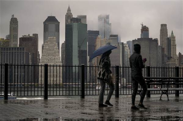
© Craig Ruttle / APPassersby walk along the Promenade in the Brooklyn Heights neighborhood as rain and clouds loom over lower Manhattan on the fifth anniversary of Superstorm Sandy Sunday, Oct. 29, 2017, in New York.
Tropical storm Philippe dissipated Sunday night after bringing strong winds and heavy rain to the Northeast on the five-year anniversary of Superstorm Sandy. But high winds downed power lines, leaving nearly a quarter of a million customers in the Northeast without electricity. Rainfall continued across the region Sunday night as the storm essentially merged with a low pressure system coming from the Great Lakes region.

The result is a nor'easter-type storm producing high wind and rain for parts of eastern New York and New England late Sunday into Monday. CNN forecasters anticipate Philippe will move into the western Atlantic Ocean by Monday afternoon. The storm formed near western Cuba a few days ago, the the National Hurricane Center said.

Early Sunday, it was racing up the Atlantic Ocean off the East Coast, moving away from Florida at about 31 mph, with sustained winds of about 50 mph. By Sunday afternoon, Philippe had merged with a front along the East Coast, the center said, canceling watches and warnings. About 45 million people in the Northeast are currently under a Flash Flood Watch.

Comment:

Update:

It is reported that 1.2 million people are without power following the storm, which forced hundreds of school closures in northern New England. The New England area appeared to get the brunt of the storm, which brought sustained winds of up to 50 mph in some spots, with a gust of 82 mph reported in Mashpee on Cape Cod in Massachusetts.

A spokesman for New Hampshire Electric Cooperative, told reporters, "I think if you're without power at this time, you should expect to remain without power, possibly for a number of days."


Cloud Lightning

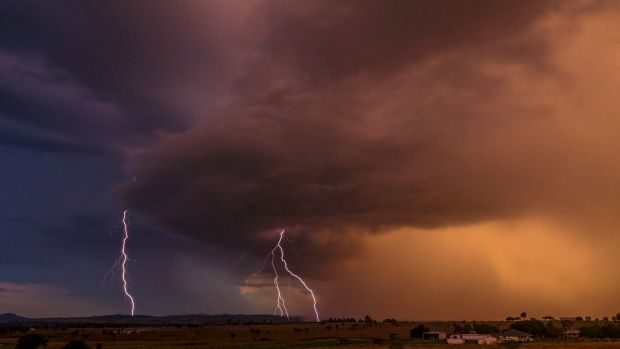
Over 176,000 lightning strikes witnessed in Queensland, Australia

Lightning split the skies above south-east Queensland on Sunday evening and Monday morning. This photo was taken at Mutdapilly.
© Thomas HinterdorferLightning split the skies above south-east Queensland on Sunday evening and Monday morning. This photo was taken at Mutdapilly.
Over 176,000 lightning strikes were witnessed in Australia's Queensland state due to severe storms, the media reported on Monday.

According to the state bureau of Meteorology, the lightning bolts ripped across the night skies on Sunday with more expected on Monday, reports the BBC.

The turbulent weather had photographers and storm chasers glued to the skies, with many capturing stunning shots of the lightning strikes.

"The sky was electric for hours, certainly more than usual storms," a Brisbane-based photographer told the BBC.


Dollar

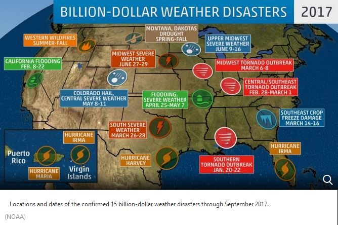
15 billion-dollar natural disasters have already impacted the U.S. this year; 2017 tied for second-most all-time which was last year

Billion dollar US weather disasters
© The Weather Channel (screen capture)
A new record for the number of billion-dollar natural disasters in the United States may be set this year, with 15 such events already confirmed through September.

There were 12 billion-dollar weather disasters that began during the first half of 2017, and hurricane season has brought three storms that resulted in massive damage, including Harvey, Irma and Maria. The official damage costs are not available yet for these storms but are expected to be billion-dollar weather disasters, according to NOAA's National Centers for Environmental Information (NCEI).

Tornado and severe thunderstorm events have made up the largest share and have added seven billion-dollar weather disasters to the list.

Two flooding events are also on the list: one in Missouri and Arkansas in late April early May and one in California in February. On the other side of the precipitation spectrum, the ongoing drought in Montana and the Dakotas has already reached more than $2 billion.

Rounding out the list is the severe March freeze in the Southeast that was preceded by unusually warm temperatures, resulting in $1 billion in damage to crops, and the wildfires in the Northwest.

In addition to the economic impact, these 15 events have resulted in the deaths of nearly 300 people.

Through September, 2017 is now tied with 2016 for the second-most billion-dollar disasters in a year, according to NOAA's database, which dates back to 1980. The year with the highest number of billion-dollar weather disasters is 2011, which had 16.
Comment: As well as the financial cost, the psychological toll of natural disasters needs to be considered also. See also:

New FEMA Director calls for Americans to develop "a true culture of preparedness" - but no one is listening