Storms
S


Tornado2

35 people injured, 600+ homes damaged as tornado rips through Sidoarja, Indonesia

Indonesia tornado
An apparent tornado hit a densely populated area of Indonesia Wednesday injuring dozens of people and damaging hundreds of homes.

According to local officials, the tornado carved a five minute long path of destruction through Tambakrejo Village in the Sidoarja regency of the country, home to nearly 2 million people.

Videos posted to social media show the twister ripping apart buildings in the area, tossing pices of them into the air with ease.

"Tornadoes are rare, but not unheard of, in wet tropical climates such as in Indonesia, said Donegan. "This tornado appeared to be of the weaker variety, but since it struck a densely populated area, it impacted a large number of people."

Indonesian disaster agency official Dwidjo Prawito told Reuters that at least 35 people were injured and more than 600 homes were damaged by the twister.


Comment: Last month three waterspouts were spotted in the waters off Thousand Islands regency, a phenomenon rarely seen in the tropics, the National Mitigation Agency said.

Three waterspout tornadoes appeared in Jakarta’s Pulau Seribu subdistrict on Monday, Oct 24, 2017
© Sutopo Purwo NugrohoThree waterspout tornadoes appeared in Jakarta’s Pulau Seribu subdistrict on Monday, Oct 24, 2017


Info

An update: Sunspots a la Cyclic Catastrophism

Sunspot Cycles
© NAOJ/Nagoya University/JAXAFig. 1 Fifty years of constant Sun observation.
This post is a response to "Variation of the Solar Microwave Spectrum in the Last Half Century", Masumi Shimojo et al. Astrophysical Journal, Volume 848, Number 1.

The abstract states:
"... we found that the microwave spectra at the solar minima of Cycles 20-24 agree with each other. These results show that the average atmospheric structure above the upper chromosphere in the quiet-Sun has not varied for half a century, and suggest that the energy input for atmospheric heating from the sub-photosphere to the corona have not changed in the quiet-Sun despite significantly differing strengths of magnetic activity in the last five solar cycles."
See Figure 1 above.

Tornado2

Rare November tornado touches down in Pittsburgh

Pittsburgh tornado
© NOAA
A tornado touched ground in the Pittsburgh area over the weekend and no one knew until now.

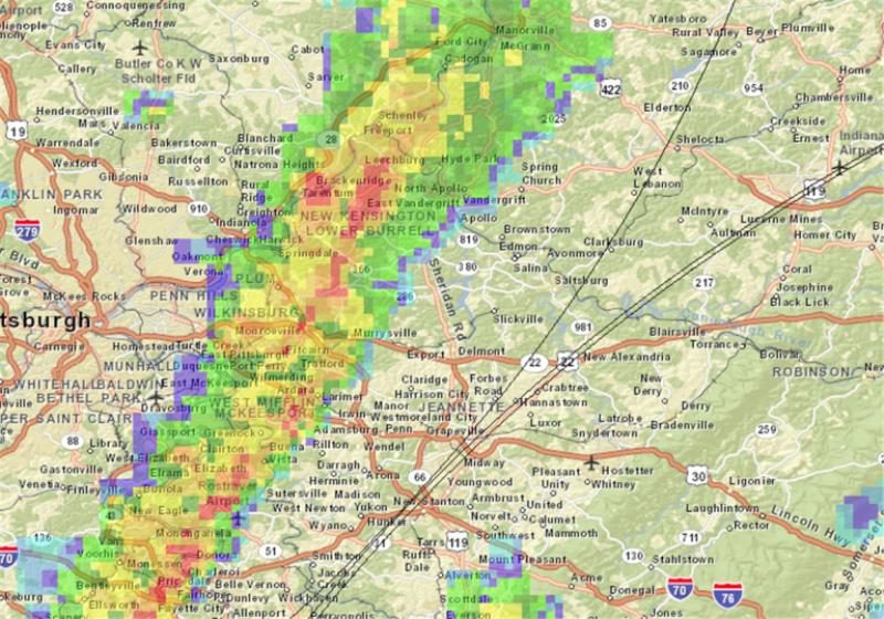
The local National Weather Service reported Monday that an EF1 tornado - with peak winds of 90 mph - struck Plum and Murrysville early Sunday morning for about four minutes along Saltsburg Road, tearing shingles from roofs, snapping tree trunks and flipping a car.

It was the second tornado to hit the region this November alone; another touched ground in Columbiana County, Ohio on Nov. 5. Before this year, there had been only five November tornadoes in the area since 1950, said NWS meteorologist Matthew Kramar.

"This is a rare event for November, and even rarer because it happened after midnight," Mr. Kramar said. "Typically it happens during the day because you need intense thunderstorms to fuel them."

The weather service, which typically examines damage firsthand after thunderstorms with high winds, received reports of damage in Murrysville Sunday. Mr. Kramar observed a flipped car and tree damage outside of a retirement community off of Saltsburg in Plum, substantial tree damage further east at Clover Commons and "considerable" tree damage near Sardis Road in Murrysville. "Just about every evergreen in a 100-yard swath was damaged. The storm cut a track right through those trees," Mr. Kramar said.

Comment: See also: 2017 hurricane season produces most reported tornadoes in U.S. in nearly a decade

Some other rare tornadoes have formed around the planet in recent times including countries such as Turkey, Netherlands, Mexico, United States, Russia and China.

Study: Tornado outbreaks are increasing - but scientists don't understand why. A coauthor of this paper states "What's pushing this rise in extreme outbreaks is far from obvious in the present state of climate science."

Recently other climate scientists were saying hurricane Harvey "should serve as a warning", as they continue to push the man-made climate change/global warming lie. They are not considering the importance of atmospheric dust loading and the winning Electric Universe model in their research. Such information and much more, are explained in the book Earth Changes and the Human Cosmic Connection by Pierre Lescaudron and Laura Knight-Jadczyk.
The accumulation of cometary dust in the Earth's atmosphere plays an important role in the increase of tornadoes, cyclones, hurricanes and their associated rainfalls, snowfalls and lightning. To understand this mechanism we must first take into account the electric nature of hurricanes, tornadoes and cyclones, which are actually manifestations of the same electric phenomenon at different scales or levels of power.
Increasing cometary and volcanic dust loading of the atmosphere (one indicator is the intensification of noctilucent clouds we are witnessing) is accentuating electric charge build-up, whereby we can expect to observe more extreme weather and planetary upheaval as well as awesome light shows and other related mysterious phenomena.

Cloud Lightning

Man dies following lightning strike in Western Australia

LIGHTNING
A West Australian race course worker who was struck by lightning last week has died in hospital.

Track curating staff member Doug Fernihough, 57, was filling divots at Northam Race Club on November 16 when he was hit by lightning, suffering a heart attack and internal injuries.

He was flown to Royal Perth Hospital for treatment, but died late on Wednesday surrounded by his family.

"On behalf of the Northam Race Club, Racing and Wagering WA and the broader WA racing fraternity, I wish to extend our thoughts and heartfelt condolences to Doug's family and friends," RWWA chief executive Richard Burt said on Thursday.

Windsock

Wyoming, US: Wind gusts top 60 mph, trucks topple on highway

toppled trucks Wyoming
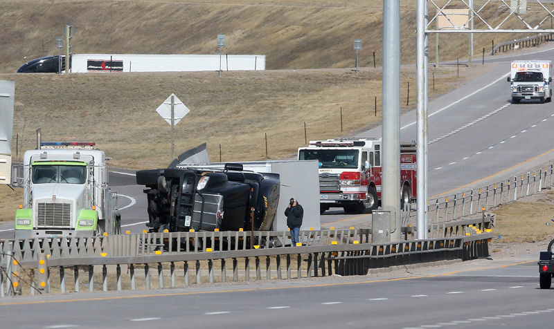
© Blaine McCartney/Wyoming Tribune EagleA truck driver speaks on the phone after his semitractor-trailer combination blew over in the southbound lane on Interstate 25 near the interchange with Interstate 80 on Monday in Cheyenne. High winds caused numerous accidents mainly south of Cheyenne, resulting in the temporary closure of I-25 leading to Colorado.
With wind gusts topping 60 miles per hour Monday, semitractor-trailer combinations were tottering and tipping on highways near Cheyenne.

A wind advisory was out most of the day for light, high-profile vehicles, such as trucks with empty cargo compartments.

But despite those warnings, nine semitractor-trailers had blown over on Interstate 25 between Cheyenne and the Colorado border between 9:26 a.m. and 5:15 p.m., according to Lt. David Wagener of the Wyoming Highway Patrol. The interstate was closed for about an hour around 3:30 p.m. to clean up crashes in both lanes, according to emails from the Wyoming Department of Transportation.

Comment: More wind speed events have been reported recently around the globe. However, overall wind speeds seem to have slowed down since1960.


Cloud Precipitation

California sees its wettest water year on record in 2016-17

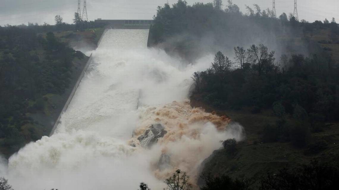
Water flows through break in the wall of the Oroville Dam spillway during heavy rains on Thursday, Feb. 9, 2017.
© Rich Pedroncelli /APWater flows through break in the wall of the Oroville Dam spillway during heavy rains on Thursday, Feb. 9, 2017.
Massive floods hit Houston and devastating hurricanes struck Puerto Rico and the Caribbean. Yet one of the more remarkable stories in the past year is the catastrophe that did not happen: massive flooding in California.

California experienced its wettest water year on record in 2016-17. In previous decades, that huge volume of water would have caused lethal floods, particularly in the Central Valley.

In part, we were lucky. Reservoirs were empty from drought so they had abundant capacity, and there was sufficient time between big storms so the rainfall didn't stack up. Dams and major levees held, though the near-failing of Oroville Dam's spillway and the flooding of the small town of Maxwell in February showed it could have been much worse.

Ice Cube

Severe storm produces large hail accumulations in Mersin, Turkey

Hail in Mersin, Turkey
© hurriyetlarge hail accumulation in Mersin, Turkey.
A severe storm brought heavy rain and walnut sized hailstones to Turkey's Mediterranean coastal city of Mersin on Sunday, November 19, 2017. According to local media it produced large hail accumulations and caused havoc for motorists.


Attention

Sandy beach that 'vanished' 12 years ago in freak storm suddenly returns overnight in Mayo, Ireland


Comment: This is the 2nd time this has happened this year on the very same Achill Island. In May, the sand at Dooagh - on the Western side of the island, that was washed away by freak storms 33 years ago leaving only bare rock, reappeared to the delight of locals. In the last few days, freak storms again were responsible for bringing the sand back to the beach at Ashleam Bay, this time on the Southern coast of the island.


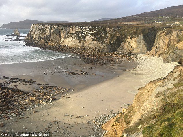
Islanders are celebrating after the beautiful beach at Ashleam Bay (pictured), which 'vanished' 12 years ago, suddenly reappeared overnight
Islanders are celebrating after a beautiful beach which 'vanished' 12 years ago suddenly reappeared overnight.

The white sands of Ashleam Bay on the picturesque island of Achill off the coast of Mayo in Ireland were washed away during a freak storm in 2005.

But following recent freak weather locals noticed the beach had suddenly returned
- and are now enjoy a stroll on the sand once more.

Seán Molloy, manager of AchillTourism.com, said recent stormy weather had cleared the beach of rocks and boulders, and Storm Brian dumped a load of sand in their place.

Mr Molloy said: 'It came back after Storm Brian. It brought the first amount of sand and cleared the boulders that was on the beach way as well.


Cloud Precipitation

Towering 8 metre waves batter rescue boat as horrific storm foils efforts to find Argentine navy sub

Footage from the vessel shows horrific conditions
A horrific storm has thwarted emergency efforts to find an Argentine navy submarine missing in the South Atlantic with 44 crew members.

Footage from a search boat showed horrendous sea conditions as waves eight metres in height crashed over the deck.

Winds of 90km have been battering the vessel for three days, according to reports.


The defence ministry said the ARA San Juan appeared to try to make contact through seven failed satellite calls on Saturday between late morning and early afternoon.

The vessel was 432 km (268 miles) off Argentina's coast when its location was last known early on Wednesday.

And as the storm complicated desperate search efforts, authorities spent Sunday trying to trace the submarine's location through data from the satellite calls without significant progress.


Comment: See also: US Navy and NASA join the hunt for missing Argentine submarine which vanished 250 miles off the coast of Patagonia almost 3 days ago - UPDATES


Cloud Precipitation

Freak hailstorm injures dozens and destroys 50 homes in Zimbabwe

Freak hailstorm destroys 50 homes and injures dozens in Zimbabwe By Strange Sounds - Nov 17, 2017
© ChronicleDesolation after an freak hailstorm hits and destroys a city in Zimbabdwe
Apocalyptic hailstorm destroys 50 houses and injures dozens in Zimbabwe on November 15, 2017. Sometimes mother nature is passive aggressive, throwing a horrifying curve ball out of the clear blue sky. Something that you could never see coming. Something that you probably didn't even know was possible. On Nov. 15th, more than 10 people were injured and rushed to Mpilo Central Hospital after their homes collapsed following an apocalyptic night hailstorm that left 50 families homeless in Emthunzini suburb on the outskirts of Bulawayo in Zimbabwe. The 1-hour-long hailstorm also destroyed properties in Pumula South and Nkulumane suburbs, with the roofs of some houses being blown away. A real disaster!

The hailstorm started just after 9PM and lasted approximately one hour. First came the strong winds, then loud noises from the outside. Before residents started to understand what was going on, the doors and roofs were blown away and the walls started shaking and bricks started falling. 50 houses were completely annilihated, had crumbled down, leaving 50 families homeless. The apocalyptic situation was worsened by power outages.