Storms
S


Cloud Precipitation

Early worries that hurricane Sandy could be a 'perfect storm'

Hurricane Sandy_1
© Joe Raedle/Getty ImagesLaura Rath and her family in Miami Beach on Thursday. The hurricane could become “a giant storm complex with a lot of energy,” one expert said.
Hurricane Sandy, which on Thursday was barreling through the Bahamas as a Category 2 storm, may be taking aim at the northeastern United States and could make landfall along the Atlantic coast early next week. If so, forecasters say, the storm could become, to use a technical term from meteorology, a whopper.

"It really could be an extremely significant, historic storm," said Brian McNoldy, a senior research associate at the University of Miami, explaining that conditions are similar to those that created the famous "perfect storm" of 1991.

Hurricane prediction is, of course, an iffy business, said Dennis Feltgen, a meteorologist and spokesman for the National Hurricane Center, who noted that the storm was still days from the East Coast and could weaken drastically or even shift course and race off into the Atlantic.

The chain of events that would make Hurricane Sandy develop into a grave threat to the coast involves a storm system known as a midlatitude trough that is moving across the country from the west. If the systems meet up, as many computer models predict, the storm over land could draw the hurricane in.

"Now you've got this giant storm complex with a lot of energy," Mr. Feltgen said. The combined systems could produce high winds, heavy rains and storm surges that would cause extensive damage.

Cloud Precipitation

Blocking Jet Stream may force "Snor'eastercane Sandy" towards Northeastern US

Image
© KeystoneUSA-Zuma/Rex FeaturesThe Manhattan skyline as Hurricane Irene approached last year. Sandy could hit New York City next week... with snow!
2011 meteorological autumn was unusual in that both a hurricane and an October snowstorm hit the north-east. They occurred two months apart, and the idea that either one would happen again in the near-term was not something high up on the probability scale. But if there is one thing more unpredictable than politics, it's the weather.

Government forecasters are warning that the US east coast is likely to be battered next week, not by a winter storm or a hurricane, but by an unusual combination of steady gale-force winds, flooding, heavy rain and possibly snow. It has already been dubbed the "snor'eastercane".

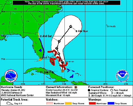
Hurricane Sandy is currently approaching the Bahamas. With 105mph winds and a central low pressure of 964 millibars, Sandy seems likely at this point to hit the east coast of the United States. Where and how Sandy will make her mark is still very much up in the up air.

Here's what we know for sure: the National Hurricane Center's latest track has Sandy staying well off the coast for the next 72 hours. Pretty much all weather models agree on this track. Most often that a storm such as Sandy would go out to sea at this point - following the warm waters of the Gulf stream.
Image
© National Hurricane Center

Cloud Grey

Why so many hurricanes this year?

Hurricane Sandy
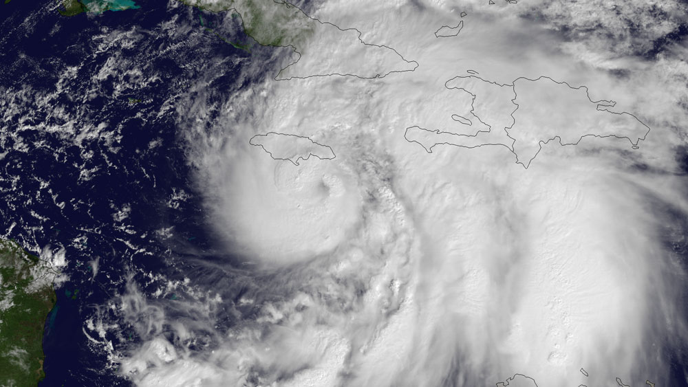
© NOAANOAA's GOES East satellite snapped this image of Hurricane Sandy at 10:45 a.m. EDT (1445 UTC) on Oct. 24, 2012, as it was headed for landfall on Jamaica.

Before the beginning of this hurricane season, back in May, forecasters thought this year would be an average one. Come August, when the season typically peaks, forecasters notched up their outlook, saying the season would in fact be busier than average.

Now it's October and it's been one of the busiest seasons on record, with 19 named storms so far this year, 10 of which became hurricanes, including Hurricane Sandy, which has the potential to strike the East Coast.

That puts the 2012 Atlantic hurricane season in rarified company. Only seven seasons since 1851 (as far back as hurricane records reach) have seen 19 or more named storms. Three of these have been within the last decade: the 2010 and 2011 seasons had 19 storms each and the 2005 season had a whopping 28 storms, the most on record, including Hurricane Katrina.

Originally the National Oceanic and Atmospheric Administration predicted there would be nine to 15 named storms this year. Then, in August, it upped its prediction to 12 to 17 named storms, with five to eight of those becoming hurricanes. (Storms are named once they attain tropical storm status - defined as a rotating, organized storm with maximum sustained winds of at least 39 mph (63 kph). A tropical storm becomes a hurricane once its top winds hit at least 74 mph (119 kph).

It's relatively unusual to have more storms than forecast, said Gerry Bell, the lead hurricane season forecaster at NOAA's Climate Prediction Center. So why has this hurricane season been busier than expected?

The underestimate can be blamed on El Niño, Bell told OurAmazingPlanet. Or rather, the lack of El Niño. Forecasters predicted that this climate pattern, characterized by warm surface temperatures in the Pacific Ocean, would have developed by now and stymied hurricane formation by its influence on the atmosphere. But it hasn't.

Cloud Grey

Dust storm in north Oklahoma shuts down interstate and causes multiple car wrecks

Image
The rear of a car sits on top of another following a crash on Interstate 35 on Thursday, Oct. 18, 2012, near Blackwell, Okla. A massive dust storm swirling reddish-brown clouds over northern Oklahoma
Tulsa - A massive dust storm swirling reddish-brown clouds over northern Oklahoma triggered a multi-vehicle accident along a major interstate Thursday, forcing police to shut down part of the heavily traveled roadway amid near blackout conditions.

In a scene reminiscent of the Dust Bowl days, choking dust suspended on strong wind gusts shrouded Interstate 35, which links Dallas and Oklahoma City to Kansas City, Mo. Video from television station helicopters showed the four-lane highway virtually disappearing into billowing dust on the harsh landscape near Blackwell, plus dozens of vehicles scattered in the median and on the shoulders.

"I've never seen anything like this," said Jodi Palmer, a dispatcher with the Kay County Sheriff's Office. "In this area alone, the dirt is blowing because we've been in a drought. I think from the drought everything's so dry and the wind is high."

The highway patrol said the dust storm caused a multi-car accident, and local police said nearly three dozen cars and tractor-trailers were involved. Blackwell Police Chief Fred LeValley said nine people were injured, but there were no fatalities.

Boat

Winter floods are on the way to Devon and Cornwall

Devon cornwall winter floods
© Northcliffe Media
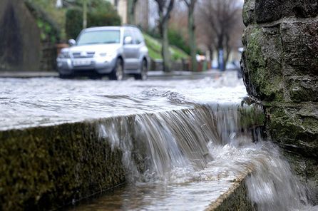
The soggy aftermath of Britain's record-breaking wet summer will increase the risk of winter floods, say experts.

Months of monsoon-like weather has left the ground unusually waterlogged for the time of year.

Under the present conditions, any spell of heavy rain might be enough to cause further serious flooding like that which swamped many homes and businesses this summer in the Westcountry and across Britain.

In contrast to last winter's drought, November to April is traditionally the wettest time of year, when soils around most of the country are close to saturation. Much of the land in the Westcountry remains usually waterlogged for the time of year - putting areas of the region under further risk of flooding.

Homeowners and businesses have been warned to prepare for more flooding misery in the region. About a month's worth of rain has already fallen in Devon and Cornwall during the first half of October.

Helen Chivers, of the Exeter-based Met Office, said: "The ground is very saturated following the unusually wet summer. Therefore at the moment there is a heightened risk of flooding.

"But things can change very quickly and we are expecting a lot of dry weather over the next week."

She said the Met Office does not expect an "unusual" period of rain over the month.

Average rainfall nationwide in November is 144mm.

Cloud Lightning

Blustery storm system sweeps through Arkansas and Mississippi - Tornadoes leave thousands without power


Thousands were left without power after a blustery storm system swept through Arkansas and Mississippi on Wednesday night, with initial reports saying it spawned at least five tornadoes.

Five people near Anguilla, Miss., were injured after their mobile home was completely destroyed, NBC station WLBT in Jackson, Miss., reported. A mother and her four children were inside the home, one child having received what appeared to be serious injuries, Sheriff Lindsey Adams told WLBT. The family was taken to a local hospital.

Not far from the scene, another mobile home was blown off its foundation and into a field. A woman was found inside and taken to a hospital with numerous injuries, WLBT reported.

In Conehatta, Miss., a suspected tornado downed dozens of trees and power lines, and damaged several structures, the Storm Prediction Center reported.

Cloud Grey

Powerful winds leave thousands without power in Denver area

It could be midday Thursday before electricity is restored to everyone who lost power in the Denver area after powerful winds. Xcel Energy Inc. says the blackouts affected about 50,000 customers in Denver, Fort Collins and Greeley starting at 10 p.m. Tuesday. Crews restored service to most by midday Wednesday.

About 5,500 were still without power Wednesday evening, and the company said it could be noon Thursday everyone's service is restored. The National Weather Service said gusts of up to 60 mph were reported in the Denver area and the northeast Colorado plains Tuesday night.

Gusts of 46 mph were reported in the northern Colorado town of Loveland on Wednesday. Fort Morgan, Akron and Holyoke in northeastern Colorado reported 40 mph gusts. The Weather Service issued a high wind warning for much of northeastern Colorado, with sustained winds of up to 40 mph and gusts of up to 60 mph possible.

Bizarro Earth

Commuter hell as flood chaos sweeps Dublin, Cork

Image
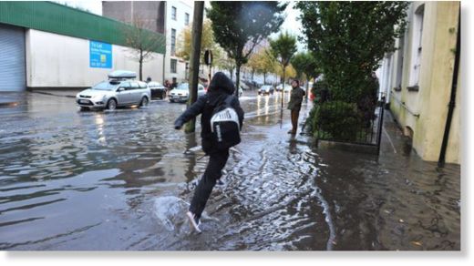
Chaos reigned this morning after the country downpours and high winds lashed overnight. Torrential rain and high winds caused havoc in Dublin and Cork -- but conditions were expected to improve by this evening. Heavy rain from around 3am was too much for the drainage systems to cope with, causing water to build up on several major roads, particularly in south and west Dublin.

And it was a similar story in Cork this morning where city streets were under as much as two-feet of water as high tide blighted the city.

Impassable

In Dublin, AA Roadwatch reported serious flooding around the Tallaght area, with the road impassable at the Jobstown Inn, and from the Old Bawn junction on the N81 Tallaght Bypass down to the M50 junction.

Several cars stalled on the N81 after driving through flooded areas. Traffic in the area was heavy inbound during morning rush hour as motorists queued to try to negotiate the floods by driving one-by-one on the higher footpaths beside the affected roads.

Further west on the N81 there was heavy flooding from Brittas to Tallaght.

Blue Planet

Hurricane Paul to hit Baja California coast Tuesday afternoon

Image
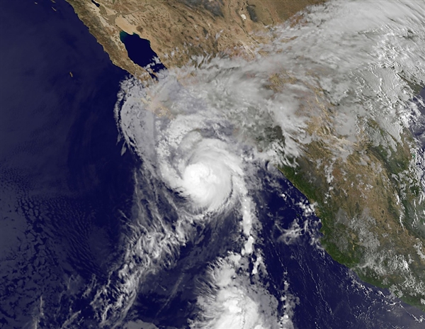
© NASA/AFP/Getty ImagesThis satellite-based image shows Hurricane Paul early Tuesday.
Hurricane Paul was expected to make landfall Tuesday afternoon along a lightly populated area of Mexico's Baja California.

Early Tuesday, the Category 2 hurricane was about 70 miles south of Cabo San Lazaro and was moving north-northeast at 21 miles per hour with maximum wind speeds of 105 mph, the U.S. National Hurricane Center reported.

Up to 10 inches of rain in some places could trigger flooding or mudslides, the center said, warning the storm would cause dangerous coastal waves.

Mexico issued a hurricane warning from Santa Fe northward to Punta Abreojos on the country's western Baja peninsula, the center said. On the east coast, a hurricane warning stretched from Mulege to San Evaristo.

While Paul was expected to weaken once it makes landfall, it should stay over Baja California for up to 36 hours, the hurricane center said.

The storm is not expected to hit the tourist resorts of Los Cabos.

Some rain from Paul should even make it to south Texas on Tuesday, weather.com reported.

Cloud Lightning

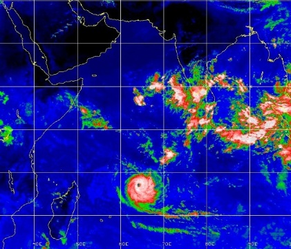
"Rare" for October: Tropical Cyclone Anais rages in the Indian Ocean

Tropical Cyclone Anais is estimated to have a maximum wind of 115 mph as of early this morning, which is equivalent to a category 3 hurricane in the Atlantic Ocean. The southwestern Indian Ocean is prone to tropical cyclones but what makes Anais so rare is that it is occurring in October, which is early springtime in the southern Hemisphere.
Image
The peak period for tropical events in this part of the world is normally during our winter months of January-March. Anais is forecast to move southwest in the general direction of Madagascar for the next five days and weaken as it moves into cooler waters and unfavorable winds.