Extreme Temperatures
S


Snowflake Cold

Historic cold record broken for Edmonton, Canada

Record cold in Edmonton, Canada
© The Weather Network
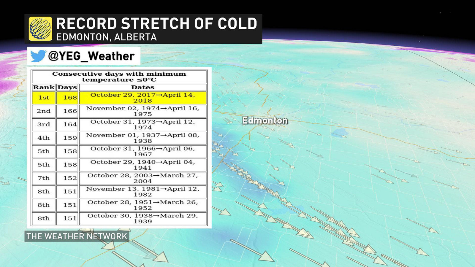
Some records weren't meant to be broken and this, is definitely one of them. The city of Edmonton, Alta., has become the (un)lucky winner of an historic stretch of cold weather. We're talking nearly SIX months of overnight lows below freezing.

Although a prolonged period of frigid conditions and even some of the coldest temperature anomalies worldwide have dominated the Alberta pattern recently, the ridiculous stretch of cold weather in Edmonton is jaw dropping. Saturday, April 14 marks the 168TH CONSECUTIVE DAY of overnight lows below freezing as recorded at Edmonton-Blatchford Airport. This puts the area in first place for the longest run of consecutive days with a minimum temperature below 0°C, ahead of the 166 day stretch in 1975.

Edmonton is known as being one of the coldest cities in Canada and with a record like this, it's certainly living up to its reputation. The last time the city got to an overnight temperature of at least 0°C was back on October 29, 2017. That's almost six months ago.

"From that point onward, we never reached above the freezing mark again in the overnight," says Weather Network meteorologist Erin Wenckstern. "We got extremely close to it on December 15, but we never quite reached the freezing mark at that point."
Snowflake

Storm brings at least 10 inches of snow to Rapid City, South Dakota

SNOW RAPID CITY
© Rapid City Journal
A little winter. A little spring. A dash of summer.

Mix them all together and you get one crazy storm system, perfectly suited for a Friday the 13th arrival date.

Mother Nature's science experiment exploded Friday, bringing rain, snow and tornadoes to a huge swath of the Great Plains and Midwest, even stretching down into the south.

In Rapid City, what started out as rain late Thursday eventually turned to snow overnight and kept a steady flow of flakes falling throughout the day Friday.


Snowflake

Up to 3 feet of fresh snowfall in the Alps

snow
It's a real mix of weather in the Alps - and indeed most of the rest of the world's major ski regions - this week.

There's been sunshine, rain and even lots of sow depending on the time and the place as the 2017-18 season continues to wind down.

Some ski areas including Andermatt and St Moritz (pictured top today) have reported 30cm of 24 hours but the biggest accumulation this week is a whopping 95cm (3 feet, 2 inches) at Isola 2000, located north of Nice in the southern French Alps.

Snowflake

Antarctic snowfall has increased 10% in the last 200 years

antarctica cores ice
© BASCores have been collected across the continent - making this the largest study of its kind
Scientists have compiled a record of snowfall in Antarctica going back 200 years.

The study shows there has been a significant increase in precipitation over the period, up 10%.

The effect of the extra snow locked up in Antarctica is to slightly slow a general trend in global sea-level rise.

However, this mitigation is still swamped by the contribution to the height of the oceans from ice melt around the continent.


Comment: Unsurprisingly no data is given to back up the claim that the snowfall is mitigated by ice melt - and there are many studies stating the contrary: Revealed: Antarctic ice growing, not shrinking


Some 272 billion tonnes more snow were being dumped on the White Continent annually in the decade 2001-2010 compared with 1801-1810.

This yearly extra is equivalent to twice the water volume found today in the Dead Sea.

Comment: See Also: Also check out SOTT's monthly documentary: SOTT Earth Changes Summary - March 2018: Extreme Weather, Planetary Upheaval, Meteor Fireballs


Ice Cube

Adapt 2030 Ice Age Report: Hudson Bay ice anomaly and winter storm front 73 F temperature drop

ice cover
Hudson Bay is still at 100% ice coverage with no end in sight of warm enough temperatures to allow melting to begin. Strangely the Canadian Ice Service has not updated any weekly ice coverage charts against 30 year average in their data sets. All other products are updated except that data set. Blizzard begins to rip across USA and Canada dropping temperatures along the storm front by 73 F. Another Atlantic Low heads toward UK and Europe.


Sources

Snowflake

More snowfall could negatively impact farmers in Wisconsin

crops
The cold weather and snow could impact when local farmers start to harvest their crops.

SkyWarn 13 Chief Meteorologist Darren Maier says the snow probably won't be leaving anytime soon.

"Until this pattern breaks to where we can get temperatures consistently back to normal or above, that possibility of seeing additional snow I'd say is likely still in the forecast," says Maier.

Agriculture Agent, Mark Hagedorn, at UW-Extension in Eau Claire says this time of year, the snow is usually gone and farmers are getting ready to do field work.

Snowflake

16 inches of snow accumulation in 24 hours in the Pyrenees - And it's not finished yet

Fontpédrouse, snow
© DRPanic on the roads in Fontpédrouse, for example, where motorists are trapped.
Translated by Sott.net

Snow has been falling in large quantities since Wednesday morning in the upper canton. The southern massifs, the Canigou and the Conflent are the most affected by this depression which should last until the end of the week.

Winter is back. It even seems to be settling permanently this week in the department where snowfall is announced in the upper canton until Friday included, according to Météo France. It must be said that in the mountains, this new snowy episode is not surprising given the significant drop in temperatures in recent hours.


Comment: Cassandra said: 'Forget global warming, prepare for Ice Age'


Snowflake

Heavy snowfall expected in Morocco until Friday

Morocco snow 2018
© jbdodane - FlickrThe Middle Atlas under snow.
The weather in Morocco is raging. Heavy snowfalls, heavy rains and strong winds are forecast until Friday in several regions of the kingdom, says the National Meteorological Directorate (MND) in an alert bulletin.

Major snowfalls from 1,500 m are scheduled from Thursday from 18:00 to Friday at 24:00 in the provinces of Ifrane, Beni Mellal, Midelt, Khenifra, Azilal, Al Haouz, Sefrou, Boulemane, Taza, El Hajeb, Ouarzazate, Tinghir and Taroudant.

Snowflake

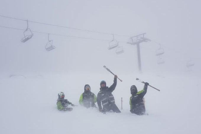
Early full-on winter storm slams New Zealand with up to 19 inches of snow in 24 hours reported

The snow hit the North Island overnight, with snow showers continuing today. The maintenance crew, loving it on the upper slopes of Turoa this morning.
50cms and road closures in April

A full-on winter storm hit New Zealand yesterday with freezing levels down to 600 metres in the far south and 1000 metres over the central North Island.

"The bulk of the storm passed over the South Island yesterday and it worked its way across the North Island overnight," said the Grasshopper, Mountainwatch's snow forecaster. "The forecast was for 40-50cm in the Canterbury ski fields with about 15 cm on the Southern Lakes ski fields. Looking at webcams and observations, this looks to be the case."

Snowflake Cold

Adapt 2030 Ice Age Report: Crop destroying blizzard for North America and more planting delays on the way

Delayed crop planting in Canada
© YouTube/Adapt 2030 (screen capture)How do you plant crops in this?
Looking across North America fields are still covered with feet of snow, temperatures are running 30F below normal, planting is delayed and storm after storm rips across the continent from land and sea. Now a blizzard across the grain belt is on tap for mid-April bringing more record snows and record cold temperatures. These patterns match perfectly with the Maunder Minimum temperatures. Also if temperatures drop 2C Canada loses 90% of its grain production, so does China and parts of Europe.


Comment: We're seeing crop failures all over the world as the seasons become more erratic with brutal winters dragging on into Spring, record frosts and more hailstorms, floods and droughts. The world is seeing a rapid upsurge in extreme weather according to a recent report, so as more crops fail the likelihood of food price rises invariably increases. See also: It is always best to be prepared. See also: And do have a listen to the SOTT Talk Radio show that was devoted to this subject:

Surviving the End of the World (as we Know it)