Earthquakes
S


Bizarro Earth

USGS: Aftershock Magnitude 6.1 - 96km SSW of Panguna, Papua New Guinea

Panguna Quake_200414
© USGS
Event Time
2014-04-20 00:15:58 UTC
2014-04-20 10:15:58 UTC+10:00 at epicenter

Location
7.167°S 155.312°E depth=18.1km (11.2mi)

Nearby Cities
96km (60mi) SSW of Panguna, Papua New Guinea
108km (67mi) SSW of Arawa, Papua New Guinea
459km (285mi) SE of Kokopo, Papua New Guinea
569km (354mi) WNW of Honiara, Solomon Islands
599km (372mi) ESE of Kimbe, Papua New Guinea

Technical Details

Red Flag

Back-to-back tremors shake Los Angeles: Big One Coming?

Image
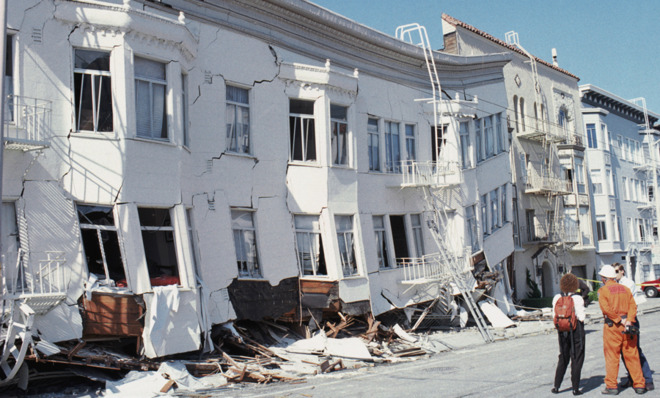
© Otto Greule Jr /Getty ImagesSan Francisco's Marina district crumbled after a 1989 earthquake that measured 7.1 on the Richter scale.
When is the Big One due?

Sometime in the next 30 years - and as soon as tomorrow. With about 300 large fault lines running beneath it, California is one of the most seismically active parts of the world, and has 37,000 tremors a year. Most are too small to be felt, but seismologists believe a couple of fault lines in particular - including the much-dreaded San Andreas - could trigger a megaquake similar to the one that flattened San Francisco in 1906, wiping out entire neighborhoods in seconds. Today, geologists say, there's a 99.7 percent chance of a Big One of at least magnitude 6.7 striking California within the next three decades, with Southern California most at risk. Fears that a big quake is imminent in Los Angeles were stoked in March when two earthquakes, including a magnitude-5.1 quake in La Habra, cracked walls, triggered landslides, and sent furniture flying. "Sooner or later there's going to be the Big One," says U.S. Geological Survey (USGS) seismologist Kate Hutton.

Alarm Clock

USGS: Earthquake Magnitude 7.8 - 68km SW of Panguna, Papua New Guinea

Earthquake 7.8 Papua New Guinea
© USGS
Event Time
2014-04-19 13:28:00 UTC
2014-04-19 23:28:00 UTC+10:00 at epicenter

Location
6.700°S 155.000°E depth=10.0km (6.2mi)

Nearby Cities
68km (42mi) SW of Panguna, Papua New Guinea
80km (50mi) SW of Arawa, Papua New Guinea
399km (248mi) SE of Kokopo, Papua New Guinea
552km (343mi) ESE of Kimbe, Papua New Guinea
623km (387mi) WNW of Honiara, Solomon Islands

Scientific data

Bizarro Earth

USGS: Earthquake Magnitude 6.9 - 62km SW of Panguna, Papua New Guinea

Panguna Quake_190414
© USGS
Event Time
2014-04-19 01:04:06 UTC
2014-04-19 11:04:06 UTC+10:00 at epicenter

Location
6.701°S 155.069°E depth=45.5km (28.2mi)

Nearby Cities
62km (39mi) SW of Panguna, Papua New Guinea
74km (46mi) SW of Arawa, Papua New Guinea
405km (252mi) SE of Kokopo, Papua New Guinea
559km (347mi) ESE of Kimbe, Papua New Guinea
616km (383mi) WNW of Honiara, Solomon Islands

Technical Details

Alarm Clock

Second earthquake in 24 hours recorded in Rutland, UK

Image
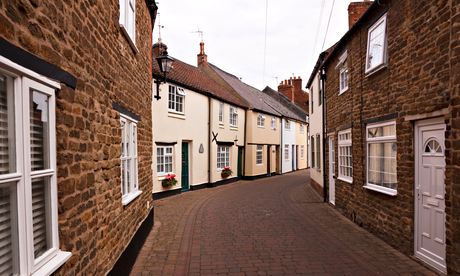
© AlamyA street in Oakham, Rutland. A British Geological Survey said it was 'unexpected' for there to be a second earthquake in exactly the same location.
3.5-magnitude quake in Oakham bigger than Thursday's, which at 3.2-magnitude had been region's biggest since 2001

Another earthquake has struck Rutland in the East Midlands, 24 hours after one shook houses for around 10 seconds.

Initial data released by the British Geological Survey (BGS) said the latest quake struck Oakham at around 7.50am on Friday and that it was bigger than Thursday's, measuring magnitude 3.5.

Thursday's 3.2-magnitude quake occurred at 7.07am and was the biggest in the region since October 2001.

A BGS spokesperson said that it was unexpected for there to be a second earthquake in exactly the same location. The organisation had already received 600 reports from members of the public, compared with 450 on Thursday.

In comments posted on the BGS Facebook page, residents in Rutland and neighbouring Lincolnshire claimed the latest quake was more powerful than the first.

Blue Planet

Magnitude-7.5 earthquake shakes Mexican capital

Mexico earthquake
A powerful, magnitude-7.5 earthquake shook central and southern Mexico on Friday. The U.S. Geological Survey said it was centered northwest of the Pacific resort of Acapulco, where many Mexicans are vacationing for the Easter holiday.

The quake was felt strongly in the resort city, as well as in Mexico's capital, but there were no immediate reports of injuries or damage.

Bizarro Earth

USGS: Earthquake Magnitude 6.0 - 122km WSW of Lata, Solomon Islands

Solomon Quake_180414
© USGS
Event Time
2014-04-18 04:13:12 UTC
2014-04-18 15:13:12 UTC+11:00 at epicenter

Location
11.155°S 164.806°E depth=10.0km (6.2mi)

Nearby Cities
122km (76mi) WSW of Lata, Solomon Islands
547km (340mi) NNW of Luganville, Vanuatu
565km (351mi) ESE of Honiara, Solomon Islands
820km (510mi) NNW of Port-Vila, Vanuatu
1111km (690mi) NNW of We, New Caledonia

Technical Details

Dominoes

Hundreds of earthquakes strike central Idaho, including strongest in 10 years

Image
© Idaho226.rssing.com
Hundreds of low-level and medium-sized earthquakes have struck central Idaho since last month, puzzling geologists who wonder whether the ruptures portend a much larger temblor to come or are merely the rumblings of a seismic fault previously thought to be dormant.

The recent earthquake swarm, beginning on March 24 and climaxed by a 4.9 magnitude tremor on Saturday, has produced no reports of injuries or severe damage but has rattled nerves in a region where Idaho's most powerful known quake, measured at 6.9, killed two children in 1983.

Saturday's earthquake was the strongest recorded in the state since 2005 and was followed on Monday by a magnitude 4.4 event that struck 10 miles north of the small ranching community of Challis, Idaho, according to the U.S. Geological Survey.

Attention

3.2 magnitude earthquake hits Rutland, England

Image
© Chris Jobs/AlamyOakham, Rutland. Tremors were felt at Stamford and the Deepings in Lincolnshire.
Residents report houses shaking during earthquake that was felt up to 28 miles away

A 3.2 magnitude earthquake near Oakham, Rutland, which was felt up to 28 miles away, is being investigated by seismologists.

The quake, triggered at a depth of 2.5 miles at 7.07am on Thursday, was recorded by the British Geological Survey (BGS), which said that its seismologists were analysing the data.

Former English rugby union player Austin Healey tweeted: "We've just had an earthquake in Oakham. The house was shaking for about 10 secs."

John Park wrote: "What the hell was that. Whole house shook about 7.07am! It was either an explosion or earthquake in Rutland. Anyone else feel it?"

Bizarro Earth

USGS: Earthquake Magnitude 6.2 - Balleny Islands region

Balleny Islands Quake_170414
© USGS
Event Time
2014-04-17 15:06:51 UTC
2014-04-18 01:06:51 UTC+10:00 at epicenter
Location
62.857°S 155.626°E depth=17.5km (10.9mi)

Nearby Cities
511km (318mi) NW of Young Island,
1999km (1242mi) SSW of Invercargill, New Zealand
2045km (1271mi) SSW of Gore, New Zealand
2111km (1312mi) SSW of Dunedin, New Zealand
2287km (1421mi) S of Hobart, Australia

Technical Details