Earthquakes
S


Bizarro Earth

Rare earthquake warning issued for Oklahoma

Oklahoma earthquakes
© USGSOklahoma earthquakes.
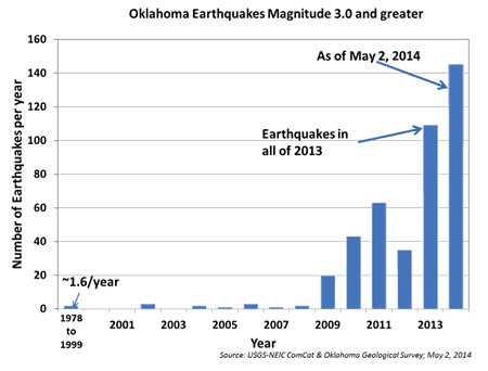
Mile for mile, there are almost as many earthquakes rattling Oklahoma as California this year. This major increase in seismic shaking led to a rare earthquake warning today (May 5) from the U.S. Geological Survey and the Oklahoma Geological Survey.

In a joint statement, the agencies said the risk of a damaging earthquake - one larger than magnitude 5.0 - has significantly increased in central Oklahoma.

Geologists don't know when or where the state's next big earthquake will strike, nor will they put a number on the increased risk. "We haven't seen this before in Oklahoma, so we had some concerns about putting a specific number on the chances of it," Robert Williams, a research geophysicist with the USGS Earthquake Hazards Program in Golden, Colorado, told Live Science. "But we know from other cases around the world that if you have an increasing number of small earthquakes, the chances of a larger one will go up."

That's why earthquakes of magnitude 5 and larger are more frequent in states such as California and Alaska, where thousands of smaller temblors hit every year.

Bizarro Earth

USGS: Earthquake Magnitude 6.0 - 9km S of Mae Lao, Thailand

Thailand Quake_050514
© USGS
Event Time
2014-05-05 11:08:43 UTC
2014-05-05 18:08:43 UTC+07:00 at epicenter

Location
19.703°N 99.683°E depth=7.4km (4.6mi)

Nearby Cities
9km (6mi) S of Mae Lao, Thailand
27km (17mi) SW of Chiang Rai, Thailand
39km (24mi) NW of Pa Daet, Thailand
52km (32mi) SSW of Mae Chan, Thailand
362km (225mi) WNW of Vientiane, Laos

Technical Details

Comment: Yearly summary of earthquake data.


Bizarro Earth

USGS: Earthquake Magnitude 6.0 - 23km ESE of Ito, Japan

Ito Quake_040514
© USGS
Event Time
2014-05-04 20:18:24 UTC
2014-05-05 05:18:24 UTC+09:00 at epicenter

Location

34.862°N 139.312°E depth=155.1km (96.4mi)

Nearby Cities
23km (14mi) ESE of Ito, Japan
33km (21mi) SE of Atami, Japan
38km (24mi) SE of Yugawara, Japan
39km (24mi) ENE of Shimoda, Japan
98km (61mi) SSW of Tokyo, Japan

Technical Details

Comment: As you can see from the chart below there have been a LOT more earthquakes recently!


Bizarro Earth

USGS: Earthquake Magnitude 6.6 - South of the Fiji Islands

Fiji Quake_050414
© USGS
Event Time
2014-05-04 09:15:53 UTC
2014-05-04 21:15:53 UTC+12:00 at epicenter

Location
24.642°S 179.084°E depth=527.6km (327.8mi)

Nearby Cities
497km (309mi) SSW of Ndoi Island, Fiji
703km (437mi) SW of Nuku'alofa, Tonga
722km (449mi) S of Suva, Fiji
777km (483mi) SSE of Nadi, Fiji
911km (566mi) S of Lambasa, Fiji

Technical Details

Target

Time-lapse reveals planet as it was rocked by record-breaking earthquakes in April 2014

earthquakes april 2014
The 6.0-magnitude earthquake that jolted parts of Indonesia today served as a reminder of just how active the seemingly-solid ground beneath us can be.

And these reminders have become increasingly frequent. On average, the world only sees one or two earthquakes per month that are 6.5-magnitude or higher.

But April produced a higher-than-normal number of the major seismic events, as revealed in this incredible time-lapse video.

Blue Planet

Heaven and Earth: Earth Changes and Strange Signs in March and April 2014

Image
Here are some of the events I picked up in March and April.

My series include strange phenomena of all kinds and awesome natural events or beautiful phenomena in the previous month or so. I try to make people focus on the important things. Enjoy!

These videos try to make people aware of the powerfulness of the world we are living in. It's but a fraction, and I'm far from covering all events from these past two months.

Do good. Good will return to you. By one way or an other.


This application is not commercial and is free to use.

I don't earn financial benefit from this video and I have the PERSONAL AGREEMENT of EACH artists' work I share in this video.

Bizarro Earth

USGS: Earthquake Magnitude 6.0 - 70km SSE of Namlea, Indonesia

Namlea Quake_020514
© USGS
Event Time
2014-05-02 08:43:37 UTC
2014-05-02 16:43:37 UTC+08:00 at epicenter

Location
3.801°S 127.435°E depth=54.2km (33.7mi)

Nearby Cities
70km (43mi) SSE of Namlea, Indonesia
83km (52mi) W of Ambon, Indonesia
172km (107mi) WSW of Amahai, Indonesia
506km (314mi) S of Kota Ternate, Indonesia
565km (351mi) NNE of Dili, East Timor

Technical Details

Bizarro Earth

USGS: Earthquake Magnitude 6.6 - 201km WNW of Ile Hunter, New Caledonia

Hunter Quake_010514
© USGS
Event Time
2014-05-01 06:36:35 UTC
2014-05-01 17:36:35 UTC+11:00 at epicenter

Location
21.502°S 170.352°E depth=105.3km (65.4mi)

Nearby Cities
201km (125mi) WNW of Ile Hunter, New Caledonia
327km (203mi) ESE of We, New Caledonia
398km (247mi) ENE of Mont-Dore, New Caledonia
409km (254mi) E of Dumbea, New Caledonia
411km (255mi) ENE of Noumea, New Caledonia

Technical Details

Magnify

California scientists go underground to monitor Hayward Fault - San Andreas Fault's sibling

Image
© ABC
Cutting a direct path through the East Bay hills, the Hayward Fault is the San Andreas Fault's less-celebrated sibling. Yet it's a seismic threat the U.S. Geological Survey has described as 'a tectonic time bomb' - ready to rupture - bringing devastation to the Bay Area.

Now, scientists at UC Berkeley hope to get a jump on the fault's next big move.

The last major quake on the Hayward Fault was in the mid-1800s, before the region became packed with properties worth an estimated $1.5 trillion.

The fault has been pretty quiet since that 6.8 magnitude event but, today, a shaker that strong could buckle Interstate 80, I-880 and partially collapse the Caldecott Tunnel - even damaging the supposedly quake-resilient new eastern span of the Bay Bridge.

Bizarro Earth

USGS: Earthquake Magnitude 6.2 - 67km NE of Nuku'alofa, Tonga

Tonga Quake_260414
© USGS
Event Time
2014-04-26 06:02:20 UTC
2014-04-25 18:02:20 UTC-12:00 at epicenter

Location
20.714°S 174.724°W depth=39.4km (24.5mi)

Nearby Cities
67km (42mi) NE of Nuku'alofa, Tonga
772km (480mi) ESE of Suva, Fiji
782km (486mi) SE of Lambasa, Fiji
823km (511mi) SSW of Apia, Samoa
823km (511mi) SSW of Tafuna, American Samoa

Technical Details