Earthquakes
S


Dominoes

Earthquake 'swarm' observed at remote Aleutian volcano - 5 volcanoes in Alaska are now simultaneously active

Semisopochnoi Island 2012
© ROGER CLIFFORD — Alaska Volcano ObservatorySemisopochnoi Island, in November 2012.
An advisory alert has been issued for a remote volcano in the western Aleutian Islands after dozens of earthquakes were reported in the area, an early sign of volcanic unrest.

The change means that five volcanoes being monitored in Alaska are now simultaneously active, the most in recent memory, said Matt Haney, a research geophysicist at the Alaska Volcano Observatory.

"We might have had four before, but we haven't had five," Haney said.

A total of 52 volcanoes in Alaska are considered by the observatory to be "historically active." All are monitored daily through satellites, and about 30 are monitored with ground-based seismometers that measure earthquake activity. On Friday, the observatory raised the color code alert level for the Semisopochnoi (pronounced Semi-so-poch-noi) volcano to "yellow," a reflection of heightened unrest.

Blackbox

Could low-frequency pulses in Earth's magnetic field forecast earthquakes?

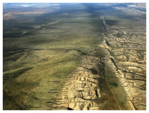
San Andreas Fault
© John L. Wiley/Creative CommonsSeismic magnetism? The brief magnetic pulses observed prior to some moderate-sized earthquakes might be triggered by chemical bonds breaking in rocks under stress (such as those deep beneath the San Andreas fault, shown).
In the days leading up to some recent moderate-sized earthquakes, instruments nearby have picked up brief low-frequency pulses in Earth's magnetic field. A few scientists have proposed that such pulses, which seemed to become stronger and more frequent just before the earthquakes occurred, could serve as an early warning sign for impending seismic activity. Now, a team has come up with a model for how these magnetic pulses might be generated, though some critics say they may have a human made origin.

Brief fluctuations in Earth's magnetic field have been detected before many earthquakes in the past 50 years, says Friedemann Freund, a crystallographer at San Jose State University in California.

For example, in the weeks before a magnitude-5.4 quake struck about 15 kilometers northeast of San Jose in October 2007, an instrument near the epicenter sensed a number of unusual magnetic pulses, presumably emanating from deep in the Earth. (The largest of them measured 30 nanoteslas, which is about 1/100,000th the typical strength of the planet's magnetic field measured at Earth's surface.) Those blips became more frequent as the day of the earthquake approached, Freund says.

More recently, prior to several medium- to moderate-sized quakes in Peru, two sensitive magnetometers recorded the same sort of pulses.

Bizarro Earth

Quakes are increasing in the Los Angeles area, but scientists aren't sure what it means

LA Quakes
© Robert Gauthier/Los Angeles TimesCesar Zamora, night manager at a 99 Cent Only store in Brea, looks over aisles of fallen goods after a 5.1 magnitude quake in March. "Every earthquake makes another earthquake more likely," says USGS seismologist Lucy Jones.
No, it's not your imagination: The Los Angeles area is feeling more earthquakes this year.

After a relatively quiet period of seismic activity in the Los Angeles area, the last five months have been marked by five earthquakes larger than 4.0. That hasn't occurred since 1994, the year of the destructive Northridge earthquake that produced 53 such temblors.

Over the next two decades, there were some years that passed without a single quake 4.0 or greater.

Earthquake experts said 2014 is clearly a year of increased seismic activity, but they said it's hard to know whether the recent string of quakes suggests that a larger one is on the way.

"Probably this will be it, and there won't be any more 4s. But the chance we will have a bigger earthquake this year is more than if we hadn't had this cluster," U.S. Geological Survey seismologist Lucy Jones said. "Every earthquake makes another earthquake more likely."

Quakes in the magnitude 4 range are large enough to be felt over wide areas but generally too small to cause much damage. The largest this year was a magnitude 5.1 in La Habra, which caused several million dollars in damage. Others hit Fontana and Rowland Heights.
Blue Planet

Best of the Web: Signs of change: Video round-up of extreme weather and seismic activity in May 2014

Image
Record flooding in the Balkans last month
Large scale disasters continue to strike with regularity, causing catastrophic damage to multiple areas around the globe, and leaving hundreds of thousands of people displaced. Rare, strange, unusually extreme and 'biblical' weather conditions have taken place the past week or so. Also included are some dramatically breathtaking weather events caught on video last month.

Thanks for watching and stay safe! Have a plan in order!


Bizarro Earth

Series of moderate earthquakes and aftershocks hit the Philippines early Sunday

Image
© USGS
A series of moderate earthquakes and aftershocks hit the Philippines early Sunday, with US geologists estimating the shallowest - a magnitude-5.1 tremor - at just one kilometre deep, but there were no initial reports of damage. The first quake struck off the southern island of Mindanao at around 3:00 am local time (1900 GMT), some 30 kilometres (17 miles) east-northeast of the city of Cortes, according to the USGS.

It was followed by at least six moderate aftershocks, the strongest a magnitude-5.3 that was four kilometres deep, the USGS said. There were no immediate reports of damage and no tsunami warning was issued.

USGS reports

via AFP

Bizarro Earth

Menacing 12-mile-high ash cloud looms over Indonesia's 'Mountain of Spirits' after volcano erupts

Image
© Sofia EfendiEruption at Mount Sangean Api in the Lesser Sunda Islands, Indonesia
This is the incredible moment when a huge volcano erupted in Indonesia sending ash spewing an estimated 12 miles into the sky.The powerful explosion took place at Mount Sangeang Api in the Lesser Sunda Islands - an area that plays host to 129 active volcanoes - and sent a distinctive spaceship-shaped ring of pyroclastic smoke high into the air.

The photographs were taken by professional photographer Sofyan Efendi during a commercial flight from Bali to the fishing town of Labuan Bajo in West Nusa Tenggara province.Scores of farmers who work but do not live on the island were ordered to leave and not return until the volcano has finished erupting, said Muhammad Hendrasto, head of Indonesia's National Volcanology Agency. There are not believed to have been any deaths or injuries as a result of the eruption.

Authorities have had Mount Sangiang Api - which means 'Mountain of Spirits' in Balinese - on high alert for almost a year, he told China's Xinhua news agency.The volcano sits in Indonesia's notorious 'Ring of Fire' - an area where a large number of earthquakes and volcanic eruptions occur in the basin of the Pacific Ocean. It has 452 volcanoes - 75 per cent of the world's total.Since Sangiang Api's first recorded eruption in 1512, it is believed to have erupted a total of 20 times.

Bizarro Earth

Strong 6.2-magnitude undersea earthquake struck off the coast of Mexico

Image
© USGS
A strong 6.2-magnitude undersea earthquake struck off the coast of Mexico Saturday, US seismologists said.

The US Geological Survey said the quake occurred around 1153 GMT and was located about 184 miles (295 kilometers) southwest of the coastal resort city of Puerto Vallarta.

They had earlier put the quake's magnitude at 6.6.

USGS data

Bizarro Earth

USGS: Earthquake Magnitude 6.2 - 259km WSW of Tomatlan, Mexico

Image
© USGS
Event Time
2014-05-31 11:53:48 UTC
2014-05-31 04:53:48 UTC-07:00 at epicenter

Location
18.852°N 107.445°W depth=10.0km (6.2mi)

Nearby Cities
259km (161mi) WSW of Tomatlan, Mexico
303km (188mi) SW of Puerto Vallarta, Mexico
306km (190mi) W of Cihuatlan, Mexico
311km (193mi) SW of Ixtapa, Mexico
877km (545mi) W of Mexico City, Mexico

Technical data

Alarm Clock

El Salvador evacuates 1000 people near Chaparrastique volcano after seismic activity

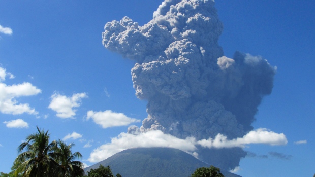
Chaparrastique volcano
© ReutersOfficials ordered at least 1,000 people to leave the immediate vicinity of the Chaparrastique volcano after seismic activity increased on Monday.
At least 1,000 people living near the Chaparrastique volcano have been evacuated as a precautionary measure after seismic activity increased at the volcano, Salvadoran civil protection authorities said Monday.

There was an explosion early Monday and the volcano then spewed reddish ash, officials said.

The Civil Protection Department said in a statement that an alert had been declared for the municipality of San Miguel, where the volcano is located. The city of San Miguel itself is 50 kilometres from the volcano. It is one of the largest cities in the Central American country.

The 2,129-metre volcano is about 145 kilometres east of San Salvador, the capital of El Salvador.

The volcano's last significant eruption was in 1976.

Map

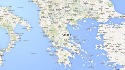
6.9 earthquake rattles islands in Greece and Turkey, dozens injured

greece map
The tremblor was widely felt in northern Greece. Several strong aftershocks, of yet undetermined magnitude, have taken place
Residents in Turkey flee in panic after the quake struck at midday

An earthquake beneath the sea shook northern Greece and western Turkey Saturday, with more than two dozen injuries reported on a Turkish island.

In Istanbul and in other parts of Turkey residents fled homes in panic after the quake struck at midday.

The private Dogan news agency said the temblor caused damage to some old houses on the island of Gokceada, off Turkey's northern Aegean coast, and 30 people were taken to a hospital with minor injuries.