Earthquakes
S


Bizarro Earth

USGS: Earthquake Magnitude 6.6 - 52km E of Buldir Island, Alaska

Buldir Quake_240614
© USGS
Event Time
2014-06-24 03:15:41 UTC
2014-06-24 15:15:41 UTC+12:00 at epicenter

Location
52.307°N 176.693°E depth=35.0km (21.7mi)

Nearby Cities
52km (32mi) E of Buldir Island, Alaska
1220km (758mi) E of Petropavlovsk-Kamchatskiy, Russia
1237km (769mi) E of Yelizovo, Russia
1237km (769mi) E of Vilyuchinsk, Russia
3035km (1886mi) W of Whitehorse, Canada

Scientific Details

Bizarro Earth

USGS: Earthquake Magnitude 6.9 - 96km SSE of Raoul Island, New Zealand

Raoul Island Quake_230614
© USGS
Event Time
2014-06-23 19:19:16 UTC
2014-06-23 07:19:16 UTC-12:00 at epicenter
Location
30.118°S 177.670°W depth=20.0km (12.4mi)

Nearby Cities
96km (60mi) SSE of Raoul Island, New Zealand
973km (605mi) NE of Whangarei, New Zealand
999km (621mi) NNE of Whakatane, New Zealand
1014km (630mi) NE of Tauranga, New Zealand
1025km (637mi) SSW of Nuku'alofa, Tonga

Scientific Details

Bizarro Earth

USGS: Earthquake Magnitude 7.9 - 24km SE of Little Sitkin Island, Alaska

Alaska Quake_230614
© USGS
Event Time
2014-06-23 20:53:10 UTC
2014-06-23 11:53:10 UTC-09:00 at epicenter

Location
51.797°N 178.759°E depth=114.4km (71.1mi)

Nearby Cities
24km (15mi) SE of Little Sitkin Island, Alaska
1370km (851mi) E of Petropavlovsk-Kamchatskiy, Russia
1387km (862mi) E of Vilyuchinsk, Russia
1388km (862mi) E of Yelizovo, Russia
2957km (1837mi) W of Whitehorse, Canada

Scientific Details

Target

Oklahoma's increase in earthquakes linked to oil well wastewater

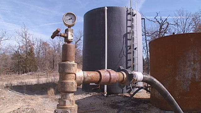
wastewater well
© business.financialpost.comWastewater well above-ground injection process.
Between 1978 and 2008, Oklahoma had just two earthquakes with a magnitude over 3.0. In 2014, thus far, there have been around 200 such earthquakes there, more even than the highly unstable state of California. (They've had 140.) Experts believe the unusual increase in earthquakes is linked to the number of wastewater wells connected to oil and gas drilling.

diagram, wastewater effect
© theresilientearth.comWastewater's effect on earthquake faults.
Wastewater wells occur when oil and gas companies inject wastewater deep underground. Scientists believe that the wastewater acts as a lubricant in existing fault lines, causing more movement. Hydraulic fracturing, commonly known as fracking, has also been linked to earthquakes, though the majority of Oklahoma's tremors were caused by wastewater wells.

Comment: The principal seismic hazard from injection-induced earthquakes comes from the disposal of wastewater into deep strata, i.e: basement formations. When the balance of applied shear stress is less than the strength of contact, the fault remains locked. Injection wells can promote a slip by increasing pore pressure, compounded by a change of load above a fault (such as the removal of oil). As faults slip, earthquakes release stored energy. The intensity of the earthquake is proportional to the stored energy and the triggers for release.


Comment: Proponents of fracking believe that a few small tremors are nothing more than the price of our modern technological civilization and environmentalists are merely creating another brouhaha. What they fail to consider is that large earthquakes around the globe have been found to specifically remote-trigger earthquakes near well sites via surface waves. A U.S. Geologic Service survey studied sites that had a long history of regional subsurface injection. Each triggered site had potential to host a moderate magnitude earthquake, suggesting critically stressed faults. And, each site had a relatively low level of seismicity rate before the first triggering episode. Industrial activity has a strong correlation to the increase in tremors. At least half of the 4.5 magnitude or larger earthquakes to strike the interior of the U.S. in the past decade have occurred in regions of injection-induced seismicity, with the seismic onset following injection by merely days or weeks.


Bizarro Earth

Stunning increase in earthquake activity in Oklahoma linked to oil and gas drilling

Image
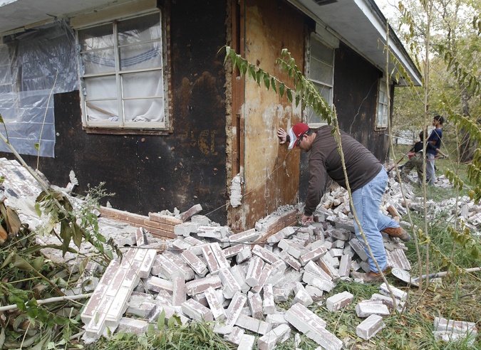
© AP PHOTO/SUE OGROCKIIn this Sunday, Nov. 6, 2011 file photo, Chad Devereaux works at cleaning up the bricks that fell from three sides of his in-laws' home in Sparks, Okla., after two earthquakes hit the area in less than 24 hours.
Between 1978 and 2008, Oklahoma had just two earthquakes with a magnitude over 3.0. In 2014, thus far, there have been around 200 such earthquakes there, more even than the highly unstable state of California. (They've had 140.) Experts believe the unusual increase in earthquakes is linked to the number of wastewater wells connected to oil and gas drilling.

Wastewater wells occur when oil and gas companies inject wastewater deep underground. Scientists believe that the wastewater acts as a lubricant in existing fault lines, causing more movement. Hydraulic fracturing, commonly known as fracking, has also been linked to earthquakes, though the majority of Oklahoma's tremors were caused by wastewater wells.
Image
Wastewater well
The USGS and Oklahoma officials are adding monitor stations to best determine which wastewater wells are causing the earthquake issue. There are currently 15 permanent stations and 17 temporary stations.

Thus far, none of the earthquakes in Oklahoma have caused major damage. However, USGS geophysicist Rob Williams believes it is only a matter of time, "Given the rate of earthquakes over the last six months, it's concerning enough to be worried about a larger, damaging earthquake happening, let alone what might happen in the future."

Alarm Clock

USGS: Earthquake Magnitude 6.4 - 85km WNW of Sola, Vanuatu

Earthquake 6.4 Vanuatu
© USGS
Event Time
2014-06-19 10:17:58 UTC
2014-06-19 21:17:58 UTC+11:00 at epicenter

Location
13.577°S 166.826°E depth=59.9km (37.2mi)

Nearby Cities
85km (53mi) WNW of Sola, Vanuatu
219km (136mi) N of Luganville, Vanuatu
487km (303mi) NNW of Port-Vila, Vanuatu
813km (505mi) N of We, New Caledonia
878km (546mi) ESE of Honiara, Solomon Islands

Scientific data

Question

Alaska shaken by mysterious series of quakes in low-seismic area

Noatak area Alaska, mountains, water
© godfreydaily.comBrooks Range near Noatak, Alaska, epicenter of one of several recent earthquakes.
A swarm of identical earthquakes has hit Alaska - taking place in the same low-seismicity area in the northwest, all at the same 5.7 magnitude. The fifth and latest event took place on Monday, leaving scientists puzzled.

The eerily similar tremors, which have been taking place regularly since April 18, woke people up at around 4 am. No one in the Inuit Eskimo community in Noatak is used to earthquakes - there are no major active fault lines and the latest such incident took place back in 1981.

The area is about 100km north of the Arctic Circle. The April swarm struck about 30km from Noatak at a depth of about 16km. Just as with previous temblors, there were no injuries, apart from minor structural cracks in Noatak.

The latest tremor epicenter was located northeast of the village, the Alaska Earthquake Center reported.

Herbert Walton told the Arctic Sounder that "the whole house shook... we're concerned."

While many slept through the quake, locals still fear "there's going to be a bigger one, because every time it happens, they seem to be getting bigger," Walton said.

The regularity is a little bit offset. While the first two events happened in rapid succession on April 18, the third event did not happen until May 3. But all four were about the same magnitude, which is part of the reason the events are being treated as a group and called a "swarm" by Mike West, with the Earthquake Center.

Comment: According to USGS, there were six M5+ quakes around Noatak since April 18, 2014: M 5.6 @ 23.4 km and M 5.3 @ 33 km on April 18; M 5.5 @ 0.9 km on May 3; M 5.5 @ 16.4 km on June 7; M 5.8 @ 15.7 km and M 5.7 @ 16 km on June 16. Swarms are more common around volcanoes and geothermal sites, but neither of these are known to be in the area of the swarm, nor do the seismologists know what faults are activating. Recent swarms include the 2008 Mogul earthquake sequence near Reno, Nevada, and a swarm that affected a Spanish island in the eastern Atlantic during the 2011-2012 eruption of a submarine volcano, causing magma to move beneath the island. This Alaskan swarm may be an indicator of greater Pacific Rim activity in the near future, as pressures continue to build between tectonic plates and electromagnetic anomalies increase.


Bizarro Earth

Twin 5.7 and 5.6 magnitude earthquakes strike offshore near Fukushima

Image
© USGS
Two moderate earthquakes struck off Japan's eastern coast near Fukushima in the early hours on Monday, the US Geological Survey said, predicting a low chance of any major damage being caused. The epicentre of the first quake, with a magnitude measuring 5.7, was located some 91 kilometres (56 miles) off the coast of Honshu, Japan's largest and most populated island, at a depth of 22 kilometres shortly after 3am local time (2330 IST Sunday).

A second, 5.6-magnitude quake struck two hours later slightly closer to shore at a depth of 39 kilometres. Cities nearest to the epicentre included Iwaki, Kitaibaraki, Namie and Hitachi, USGS said. The same coastline was struck by a devastating quake and subsequent tsunami in 2011 that killed more than 18,000 people and sparked a meltdown at the Fukushima power plant - the world's worst nuclear accident in a generation.

USGS data magnitude 5.6
USGS data magnitude 5.7

Dominoes

USGS: Earthquake Magnitude 6.4 - South Indian Ocean

Earthquake 6.4 South Indian Ocean
© USGS
Event Time
2014-06-14 11:11:00 UTC
2014-06-14 17:11:00 UTC+06:00 at epicenter

Location
10.056°S 91.056°E depth=7.1km (4.4mi)

Nearby Cities
671km (417mi) WNW of West Island, Cocos Islands
1418km (881mi) WSW of Bengkulu, Indonesia
1439km (894mi) SW of Padang, Indonesia
1442km (896mi) SW of Sungaipenuh, Indonesia
671km (417mi) WNW of West Island, Cocos Islands

Scientific data

Dominoes

Earthquake swarms at Hawaii's biggest volcano, Mauna Loa betray magma moving deep below

Mona Loa 2013
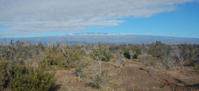
© Erik Klemetti, taken March 2013.The broad shield of Mauna Loa in Hawaii, the largest active volcano on Earth.
We just passed the 30th anniversary of the last major eruptive period at Hawaii's biggest volcano, Mauna Loa. Since those eruptions in 1984, the volcano has been quiet, letting the continuous activity at Kilauea take the spotlight. However, by no means is Mauna Loa going to be quiet forever and over the past year, there have been increasing signs that the volcano might be preparing to jump back into action.