Earthquakes
S


2 + 2 = 4

Stupid: Earthquakes double in 2014, but scientists say they are not linked

Image
If you think there have been more earthquakes than usual this year, you're right. A new study finds there were more than twice as many big earthquakes in the first quarter of 2014 as compared with the average since 1979.

"We have recently experienced a period that has had one of the highest rates of great earthquakes ever recorded," said lead study author Tom Parsons, a research geophysicist with the U.S. Geological Survey (USGS) in Menlo Park, California.

But even though the global earthquake rate is on the rise, the number of quakes can still be explained by random chance, said Parsons and co-author Eric Geist, also a USGS researcher. Their findings were published online June 21 in the journal Geophysical Research Letters.

With so many earthquakes rattling the planet in 2014, Parsons actually hoped he might find the opposite -- that the increase in big earthquakes comes from one large quake setting off another huge shaker. Earlier research has shown that seismic waves from one earthquake can travel around the world and trigger tiny temblors elsewhere.

Comment: It is possible that earthquakes are caused by the impact (or overhead explosion) of space rocks.From 2008, Meteorites, Asteroids, and Comets: Damages, Disasters, Injuries, Deaths, and Very Close Calls:

"Over the past few years, while SOTT.net has been tracking the increasing flux of fireballs and meteorites entering the earth's atmosphere, we have been, by turns, amused and horrified at the ignorant reactions and declarations that issue from academia and the media regarding these incursions. A few years ago, we read that "this is a 'once in a hundred years' event!" Not long after it was a "once in a lifetime" event. Still later, after a lot more incidents it became a "once in a decade" event. More recently, it has been admitted in some quarters that meteorites hit the ground (as opposed to safely burning up in the atmosphere) several times a year! And of course, we have discovered the fact that the governments of our planet are well aware that there are atmospheric explosions from such bodies numerous times a year. We have also learned in this series that the frequent reports of unusual booms and shaking of the ground is often due to such overhead explosions. Yet the media steadfastly refuses to honestly address this issue, though we have noted a plethora of recent articles presenting opposing academic arguments designed to put the populace back to sleep, to reassure them that there is nothing to worry about, that such things only happen every 100,000 years or so, and certainly, the Space Watch Program is going to find all the possible impactors and take care of things."

See also: Impact Hazards on a Populated Earth?


Info

Swarm of earthquakes reported in northwest Yellowstone National Park

Image
© National Park Service
Seismographs have picked up a swarm of earthquakes in the northwestern corner of Yellowstone National Park, including dozens early Tuesday.

The University of Utah Seismograph Station reported five small earthquakes including those with magnitudes of 3.4, 2.7 and 3.2 in a 20-minute period starting at 3:33 a.m. in an area 16 to 18 miles south of Gardiner.

Earthquake information specialist Paul Roberson said there were another 20 to 30 small quakes Tuesday morning that hadn't yet been posted on the university's website. He called it a fairly normal swarm for Yellowstone. He didn't expect there to be any damage.

Seismographs recorded 31 quakes in the same area south of Gardiner on Saturday, while another 23 were reported last Wednesday and Thursday in an area between 18 and 19 miles east-southeast of West Yellowstone.

Attention

Earthquake rocks southern Mexico; houses destroyed, 3 dead

Image
© Via twitter@chriscelada
At least 3 people have been killed after a powerful 7.1-magnitude quake struck the southern Mexican state of Chiapas and neighboring Guatemala.

The earthquake struck 14km offshore from the city of Mazatan in Mexico, but strong tremors were felt across the border in Guatemala. Significant damages were reported in the region of San Marcos in Guatemala where the quake damaged buildings and triggered landslides.

"This quake was pretty strong. There are houses destroyed," Luis Rivera, governor of the San Marcos region, told Reuters. A spokesperson from the local emergency services said three people had been reported dead in the area.

Attention

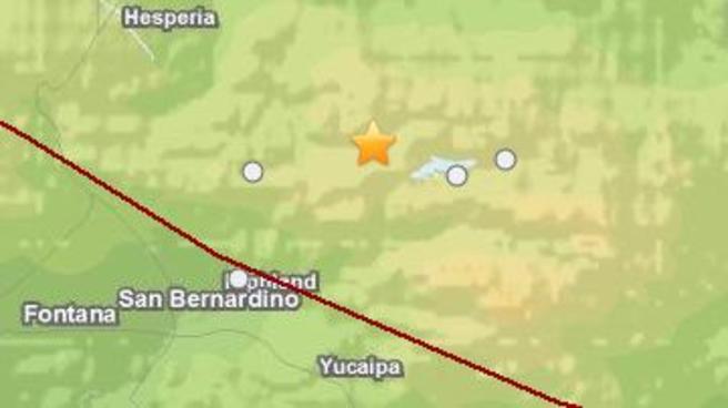
Another rumble: Magnitude-3.1 earthquake reported near Big Bear Lake, California

Image
Magnitude-3.1 earthquake hits 6 miles near Big Bear Lake just before 2 a.m. on Monday, July 7, 2014.
3.1- magnitude earthquake was reported near Big Bear Lake Monday morning, according to the US Geological Survey.

The quake was reported at 1:51 a.m. about 6 miles from the lake. An aftershock, a magnitude-1.2, was reported at 2:18 a.m.

This earthquake comes after a magnitude-4.6 had hit the same area on Saturday morning.

Attention

Light quake rattle nerves in Southern California

Image
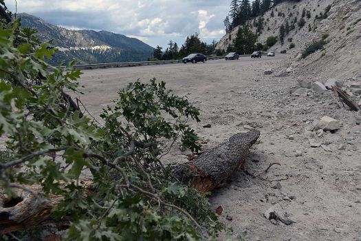
© Rick Sforza/APPart of a tree broken lies along State Route 18 after a rockslide blocked the road in the Southern California community of Snow Valley, enroute to Big Bear Lake on Saturday, July 5, 2014. Randy Naquin of the San Bernardino County Sheriff's Department said he had no reports of damage from the widely felt small earthquake on Saturday
A small earthquake rattled nerves and jostled store shelves in and around the Southern California community of Big Bear Lake on Saturday.

Randy Naquin of the San Bernardino County Sheriff's Department said he had no reports of damage from the widely felt temblor. But the state Transportation Department said a section of nearby highway was closed by a rockslide. It wasn't immediately clear if the slide had been caused by the shaking.

City News Service reported that snowplows were dispatched to clear rocks and at least six vehicles were stranded temporarily.

Alarm Clock

USGS: Earthquake Magnitude 6.0 - 88km SE of Sinabang, Indonesia

Earthquake 6.0 Sinabang, Indonesia
© USGS
Event Time
2014-07-05 09:39:30 UTC
2014-07-05 15:39:30 UTC+06:00 at epicenter

Location

1.995°N 97.015°E depth=30.0km (18.6mi)

Nearby Cities
88km (55mi) SE of Sinabang, Indonesia
198km (123mi) W of Sibolga, Indonesia
204km (127mi) SW of Kabanjahe, Indonesia
241km (150mi) SW of Binjai, Indonesia
534km (332mi) WSW of Kuala Lumpur, Malaysia

Scientific data

Bizarro Earth

USGS: Earthquake Magnitude 6.6 - 193km S of Taron, Papua New Guinea

Taron Quake_040714
© USGS
Event Time
2014-07-04 15:00:26 UTC
2014-07-05 01:00:26 UTC+10:00 at epicenter

Location
6.205°S 152.821°E depth=10.0km (6.2mi)

Nearby Cities
193km (120mi) S of Taron, Papua New Guinea
214km (133mi) SSE of Kokopo, Papua New Guinea
300km (186mi) W of Arawa, Papua New Guinea
305km (190mi) ESE of Kimbe, Papua New Guinea
717km (446mi) ENE of Port Moresby, Papua New Guinea

Scientific Data

Bizarro Earth

USGS: Earthquake Magnitude 6.3 - 236km ESE of Raoul Island, New Zealand

Raoul Quake_030714
© USGS
Event Time
2014-07-03 19:50:05 UTC
2014-07-03 07:50:05 UTC-12:00 at epicenter

Location
30.309°S 175.765°W depth=33.0km (20.5mi)

Nearby Cities
236km (147mi) ESE of Raoul Island, New Zealand
1018km (633mi) S of Nuku'alofa, Tonga
1079km (670mi) NE of Whakatane, New Zealand
1087km (675mi) NNE of Gisborne, New Zealand
1103km (685mi) ENE of Whangarei, New Zealand

Scientific Data

Bizarro Earth

USGS: Earthquake Magnitude 6.2 - Bonin Islands, Japan region

Bonin Quake_300614
© USGS
Event Time
2014-06-30 19:55:32 UTC
2014-07-01 04:55:32 UTC+09:00 at epicenter

Location
28.354°N 138.864°E depth=512.4km (318.4mi)

Nearby Cities
359km (223mi) WNW of Chichi-shima, Japan
656km (408mi) SSE of Shingu, Japan
682km (424mi) SSE of Owase, Japan
683km (424mi) SSE of Tanabe, Japan
817km (508mi) S of Tokyo, Japan

Scientific Data

Bizarro Earth

Volcanic activity worldwide for 29 Jun 2014: Volcanoes Stromboli, Kilauea, Sakurajima

Stromboli (Eolian Islands, Italy): Activity remains elevated. A high level of magma causes continuous spattering and many strombolian eruptions from several vents on the crater terrace:


Frequent rockfalls are occurring on the Sciara del Fuoco, but (so far at least) no new lava overflows.

Sakurajima (Kyushu, Japan):
Image
Ash plume hovering over the southeastern sector of Sakurajima this morning (Tarumizu webcam)
A stronger phase of activity is occurring at the volcano. During the past 24 hours, 4 vulcanian-type explosions were registered, ejecting ash plumes to up to 13,000 ft (4.2 km) altitude. In addition, the volcano has continuous phases of ash emissions following the explosions. Ash plumes, some of them relatively thick have been drifting S, SE and E. Compared to last year, the volcano has been less active, however. So far, there have been approx. 240 recorded eruptions (explosions), while this number last year at the same time was already almost double (435).

Kilauea (Hawai'i): (29 Jun) A new lava breakout occurred Friday early morning (local time) from a new vent on the outer northern flank of Pu'u 'O'o crater. It feeds a new lava flow with several branches headed to the north and northeast. The most advanced of the them traveled to the NW and had quickly reached a length of approx 1 km yesterday, but has not advanced much since.
Image
The event was marked by a sudden deflation of the cone, indicating that magma drained from underneath the Pu'u 'O'o crater terrace and moved to the new vent. This rapid drop in magma level under the crater terrace resulted in the collapse of several of the spatter cones. Until yesterday, these had been the site of frequent overflows and were feeding the Kahaual'a2 flow field.

Overall, activity at the volcano has been relatively stable over the past months, with good magma supply to both the summit lava lake in Halema'uma'u and the Pu'u 'O'o vents on the eastern rift zone in 10 km distance. The new vent at Pu'u 'O'o is simply a change in the surface configuration of vents for Kilauea's continued magma supply.