Earthquakes
S


Alarm Clock

Channel Islands hit by biggest earthquake in 90 years

The biggest earthquake in Jersey and Guernsey on the Channel Islands for almost 90 years has struck, with a magnitude of 4.2.

Rumbles of sounds were heard as windows rattled when the quake struck at a depth of seven miles around 12 miles west of St Helier at 12.54pm.
Channel Islands earthquake
© GoogleJersey hit by biggest earthquake in 90 years.
The British Geological Survey (BGS) said it was the largest earthquake to have hit the region since a 5.6-magnitude quake on February 17, 1927.A spokesman for the BGS said it was also felt weakly on the South Coast of England, but only caused "very minor" damage.

One local thought a plane had crashed nearby, while another reported that the impact was enough to make them jump and go outside.

Alarm Clock

USGS: Earthquake Magnitude 6.8 - 129km ESE of Namie, Japan

Earthquake 6.8 Japan
© USGS
Event Time
2014-07-11 19:22:00 UTC
2014-07-12 04:22:00 UTC+09:00 at epicenter

Location
37.069°N 142.364°E depth=13.3km (8.2mi)

Nearby Cities
129km (80mi) ESE of Namie, Japan
131km (81mi) E of Iwaki, Japan
147km (91mi) ENE of Kitaibaraki, Japan
151km (94mi) ENE of Takahagi, Japan
284km (176mi) ENE of Tokyo, Japan

Scientific data

Comment: This is getting uncomfortably close to Fukushima! Namie lies in Fukushima prefecture.


Bizarro Earth

'Sonic boom' earthquake shatters expectations

Super-deep earthquakes
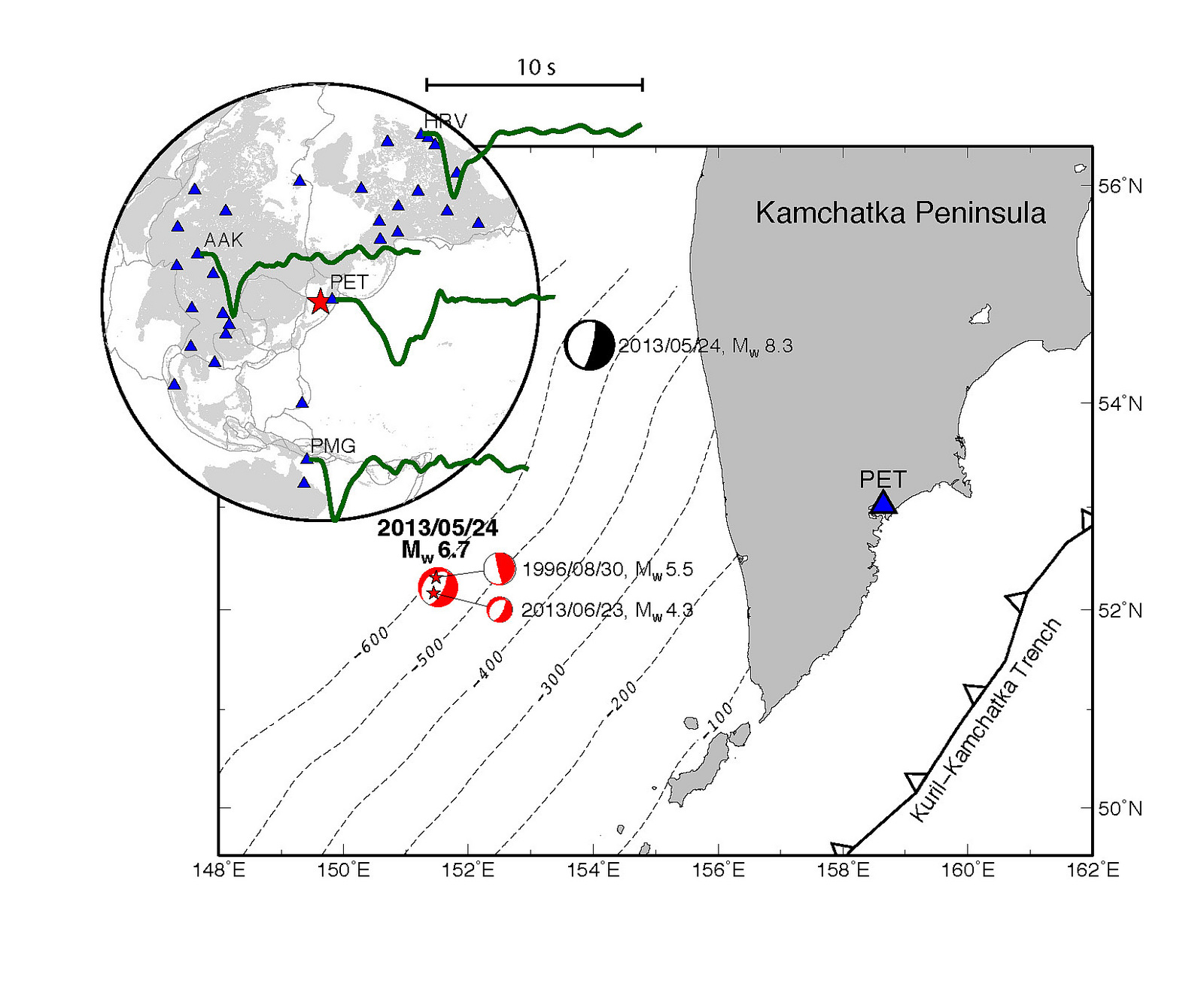
© Scripps Institution of OceanographyThe locations of two super-deep earthquakes offshore of Kamchatka in 2013.
One of the world's deepest earthquakes was also a rare supersonic quake, upending ideas about where these unusual earthquakes strike.

Only six supersonic (or supershear) earthquakes have ever been identified, all in the last 15 years. Until now, they all showed similar features, occurring relatively near the Earth's surface and on the same kind of fault. But last year, a remarkably super-fast and super-deep earthquake hit below Russia's Kamchatka Peninsula, breaking the pattern.

"This was very surprising," said Zhongwen Zhan, lead author of the study, published today (July 10) in the journal Science. "It's not only deep, it's supershear, and it's also quite small."

The weird earthquake struck May 24, 2013, about 398 miles (642 kilometers) beneath the Sea of Okhotsk offshore of the Kamchatka Peninsula. The magnitude-6.7 quake was an aftershock to the largest deep earthquake on record, a magnitude 8.3 that also hit May 24.

Alarm Clock

USGS: Earthquake Magnitude 6.3 - 13km NNE of Port-Vila, Vanuatu

Earthquake 6.3 Vanuatu
© USGS
Event Time
2014-07-08 12:56:26 UTC
2014-07-08 23:56:26 UTC+11:00 at epicenter

Location
17.617°S 168.359°E depth=114.0km (70.8mi)

Nearby Cities
13km (8mi) NNE of Port-Vila, Vanuatu
263km (163mi) SSE of Luganville, Vanuatu
382km (237mi) NNE of We, New Caledonia
540km (336mi) NNE of Dumbea, New Caledonia
13km (8mi) NNE of Port-Vila, Vanuatu

Scientific data

Bizarro Earth

USGS: Earthquake Magnitude 6.9 - 2km NNE of Puerto Madero, Mexico

Puerto Madero Quake_070714
© USGS
Event Time
2014-07-07 11:23:55 UTC
2014-07-07 06:23:55 UTC-05:00 at epicenter

Location
14.742°N 92.409°W depth=60.0km (37.3mi)

Nearby Cities
2km (1mi) NNE of Puerto Madero, Mexico
22km (14mi) SW of Tapachula, Mexico
29km (18mi) NW of Suchiate, Mexico
29km (18mi) WNW of Ciudad Tecun Uman, Guatemala
204km (127mi) W of Guatemala City, Guatemala

Scientific Data

Boat

Tsunami warning triggered by 7.9 earthquake, western Aleutian Islands

Image
© NBC Bay Area
A magnitude-7.9 earthquake off the western Aleutian Islands shortly before 1 p.m. Monday triggered a tsunami warning over a wide area but generated only a small wave in one community, according to the National Tsunami Warning Center.

No reports of damage or injury related to the quake had been received by the Alaska Department of Homeland Security by 5 p.m. Monday, said department spokesperson Jeremy Zidek.

An initial tsunami warning for coastal areas from Nikolski to Attu, plus the Pribilof Islands to the north, was downgraded to an advisory a couple of hours after the 12:53 p.m. quake, and the advisory was canceled by 4:45 p.m., according to the NTWC.

The agency had advised people in the warning area to move to higher ground inland and to avoid the coast until local emergency officials indicated it was safe to return.

At 1:43 p.m., a small tsunami of just over half a foot was recorded at Amchitka.

Comment: The Aleutian Islands are a very busy area for earthquakes:

Earthquake Felt in Aleutian Islands
Powerful 7.2 quake shakes Alaska's Aleutian Islands
Alaska: Earthquakes Hit Remote Aleutian Islands
Alaska: Earthquake Magnitutde 6.3 - Andreanof Islands, Aleutian Islands
Alaska: Earthquake Magnitude 6.1 - Andreanof Islands, Aleutian Island
Alaska: Earthquake Magnitude 6.4 - Andreanof Islands, Aleutian Islands
US: Alaska - Earthquake Magnitude 5.1 - Fox Islands, Aleutian Islands
US Alaska: Earthquake Magnitude 7.2 - Fox Islands, Aleutian Islands
US Alaska: Earthquake Magnitude 5.8 - Fox Islands, Aleutian Islands
USGS: Earthquake Magnitude 6.2 - Fox Islands, Aleutian Islands, Alaska
Fox and Aleutian Islands, Alaska - Earthquake Magnitude 6.8
Magnitude-6.1 quake shakes Aleutian Islands, Alaska
Earthquake 'swarm' observed at remote Aleutian volcano - 5 volcanoes in Alaska are now simultaneously active
Near Islands, Aleutian Islands, Alaska - Earthquake Magnitude 6.1
Alaska: Earthquake Magnitude 5.6 - Andreanof Islands, Aleutian Islands
Earthquake Magnitude 6.0 - Aleutian Islands, Alaska
Alaska: Earthquake Magnitude 6.7 - Fox Islands, Aleutian Islands


2 + 2 = 4

Stupid: Earthquakes double in 2014, but scientists say they are not linked

Image
If you think there have been more earthquakes than usual this year, you're right. A new study finds there were more than twice as many big earthquakes in the first quarter of 2014 as compared with the average since 1979.

"We have recently experienced a period that has had one of the highest rates of great earthquakes ever recorded," said lead study author Tom Parsons, a research geophysicist with the U.S. Geological Survey (USGS) in Menlo Park, California.

But even though the global earthquake rate is on the rise, the number of quakes can still be explained by random chance, said Parsons and co-author Eric Geist, also a USGS researcher. Their findings were published online June 21 in the journal Geophysical Research Letters.

With so many earthquakes rattling the planet in 2014, Parsons actually hoped he might find the opposite -- that the increase in big earthquakes comes from one large quake setting off another huge shaker. Earlier research has shown that seismic waves from one earthquake can travel around the world and trigger tiny temblors elsewhere.

Comment: It is possible that earthquakes are caused by the impact (or overhead explosion) of space rocks.From 2008, Meteorites, Asteroids, and Comets: Damages, Disasters, Injuries, Deaths, and Very Close Calls:

"Over the past few years, while SOTT.net has been tracking the increasing flux of fireballs and meteorites entering the earth's atmosphere, we have been, by turns, amused and horrified at the ignorant reactions and declarations that issue from academia and the media regarding these incursions. A few years ago, we read that "this is a 'once in a hundred years' event!" Not long after it was a "once in a lifetime" event. Still later, after a lot more incidents it became a "once in a decade" event. More recently, it has been admitted in some quarters that meteorites hit the ground (as opposed to safely burning up in the atmosphere) several times a year! And of course, we have discovered the fact that the governments of our planet are well aware that there are atmospheric explosions from such bodies numerous times a year. We have also learned in this series that the frequent reports of unusual booms and shaking of the ground is often due to such overhead explosions. Yet the media steadfastly refuses to honestly address this issue, though we have noted a plethora of recent articles presenting opposing academic arguments designed to put the populace back to sleep, to reassure them that there is nothing to worry about, that such things only happen every 100,000 years or so, and certainly, the Space Watch Program is going to find all the possible impactors and take care of things."

See also: Impact Hazards on a Populated Earth?


Info

Swarm of earthquakes reported in northwest Yellowstone National Park

Image
© National Park Service
Seismographs have picked up a swarm of earthquakes in the northwestern corner of Yellowstone National Park, including dozens early Tuesday.

The University of Utah Seismograph Station reported five small earthquakes including those with magnitudes of 3.4, 2.7 and 3.2 in a 20-minute period starting at 3:33 a.m. in an area 16 to 18 miles south of Gardiner.

Earthquake information specialist Paul Roberson said there were another 20 to 30 small quakes Tuesday morning that hadn't yet been posted on the university's website. He called it a fairly normal swarm for Yellowstone. He didn't expect there to be any damage.

Seismographs recorded 31 quakes in the same area south of Gardiner on Saturday, while another 23 were reported last Wednesday and Thursday in an area between 18 and 19 miles east-southeast of West Yellowstone.

Attention

Earthquake rocks southern Mexico; houses destroyed, 3 dead

Image
© Via twitter@chriscelada
At least 3 people have been killed after a powerful 7.1-magnitude quake struck the southern Mexican state of Chiapas and neighboring Guatemala.

The earthquake struck 14km offshore from the city of Mazatan in Mexico, but strong tremors were felt across the border in Guatemala. Significant damages were reported in the region of San Marcos in Guatemala where the quake damaged buildings and triggered landslides.

"This quake was pretty strong. There are houses destroyed," Luis Rivera, governor of the San Marcos region, told Reuters. A spokesperson from the local emergency services said three people had been reported dead in the area.

Attention

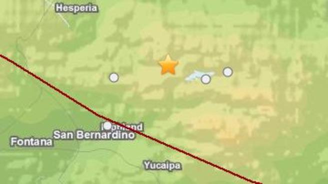
Another rumble: Magnitude-3.1 earthquake reported near Big Bear Lake, California

Image
Magnitude-3.1 earthquake hits 6 miles near Big Bear Lake just before 2 a.m. on Monday, July 7, 2014.
3.1- magnitude earthquake was reported near Big Bear Lake Monday morning, according to the US Geological Survey.

The quake was reported at 1:51 a.m. about 6 miles from the lake. An aftershock, a magnitude-1.2, was reported at 2:18 a.m.

This earthquake comes after a magnitude-4.6 had hit the same area on Saturday morning.