Earthquakes
S


Fish

Earthquake precursor? Over 100 rare deep-sea fish caught off the coast of Kochi, Japan days before major event

Image
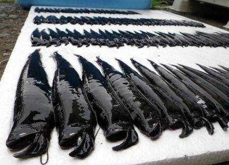
Over 100 Photonectes deep-sea fish were caught in shallow water off Japan coast on July 7th 2014. A sign for the July 13th earthquake?
A catastrophe is happening in the depths of the sea but nobody knows why!

Was it a sign for the July 13, 2014 earthquake? Reading sign before Japan earthquake in July 2014!

Japanese Fishermen catch 105 "Photonectes" fish near the coast of the province of Kochi.

But, what's weird is that this fish species naturally lives at 1,000 meters under the water surface

According to the fishermen, fishing nets were only 70 meters deep. Moreover, another rare deep-sea fish was caught in abundance (46 tons) although the daily average is about 200 kilo..

Comment: See also: Creatures from the deep signal major Earth Changes: Is anyone paying attention?


X

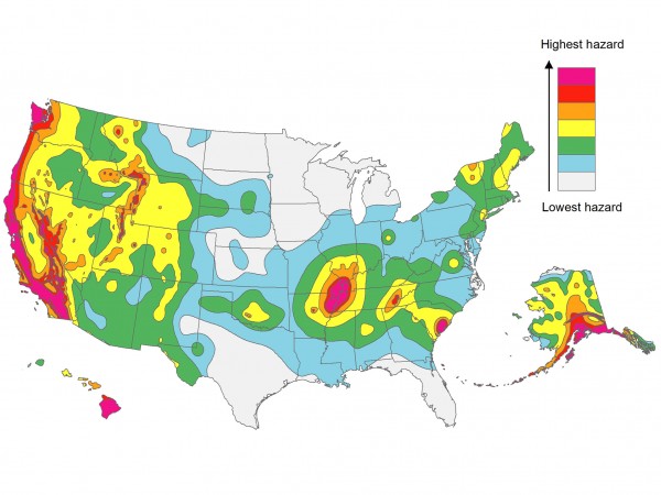
U.S.Geologic Survey: Earthquake risk increased for half of U.S.

Image
© AP/USGS
A new federal earthquake map dials up the shaking hazard just a bit for about half of the United States and lowers it for nearly a quarter of the nation.

The U.S. Geologic Survey updated Thursday its national seismic hazard maps for the first time since 2008, taking into account research from the devastating 2011 earthquake and tsunami off the Japanese coast and the surprise 2011 Virginia temblor.

Most of the changes are slight. Project chief Mark Petersen said parts of Washington, Oregon, Utah, Oklahoma, Colorado, Wyoming and Tennessee moved into the top two hazard zones.

Map

New map points up future hot spots for U.S. earthquakes

us earthquake hotspots
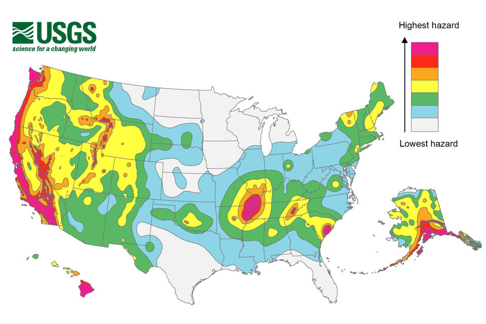
© U.S. Geological SurveyHot spots: California is still a seismic hazard hot spot—but the latest earthquake risk maps suggest a higher risk of damaging quakes than previously estimated.
Earthquake risk assessments can seem pretty abstract at first glance, with their "percent probabilities" and "peak ground accelerations." But the U.S. Geological Survey's (USGS's) national hazard maps, updated periodically, pack a powerful punch: Insurance companies and city planners rely heavily on the maps, which influence billions of dollars in construction every year. Today, USGS scientists released the most recent earthquake hazard assessments for the country. Although the picture hasn't changed much on a national scale since the last report in 2008, the devil is in the details, the report's authors say - and some areas in the country are now considered to be at higher risk for powerful quakes than once thought.

The best-known earthquake zones - California, the Pacific Northwest, and the Intermountain West - still dominate the hazard picture. Farther east, hot spots around the New Madrid Seismic Zone in the center of the country and Charleston, South Carolina, reflect the memory of powerful historical quakes (in 1811 to 1812 and 1886, respectively). But, in fact, all 50 states have the potential for earthquakes, and damaging ground shaking could happen in 42 of the 50 states within 50 years, the new report suggests. Of those, 16 states, all of which have had earthquakes of at least magnitude 6 in historical times, are considered highly likely to experience damaging ground shaking.

To assess the risk of where and how often future earthquakes will occur, and how hard the ground will shake, scientists are constantly seeking new data from these regions and using them to develop new ways of modeling ground motion, says Mark Petersen, a seismologist at USGS in Golden, Colorado, and the lead author of the new report. Among the latest temblors incorporated into the assessment is the 2011 5.8-magnitude Virginia earthquake, which "helped us understand better ground shaking in the central and eastern United States," Petersen says. New data also came from the U.S. Nuclear Regulatory Commission (NRC), which in 2010 published its own risk assessment for earthquake damage to its power plants in the central and eastern United States. These all suggest the region has the potential to experience an even more powerful quake.
Alarm Clock

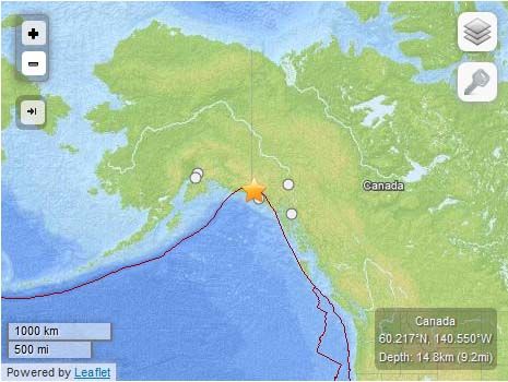
USGS: Earthquake Magnitude 6.0 - 95km NNW of Yakutat, Alaska

Earthquake in Yakutat Alaska
© USGS
Event Time
2014-07-17 11:49:37 UTC
2014-07-17 04:49:37 UTC-07:00 at epicenter

Location
60.217°N 140.550°W depth=14.8km (9.2mi)

Nearby Cities
95km (59mi) NNW of Yakutat, Alaska
300km (186mi) W of Whitehorse, Canada
411km (255mi) NW of Juneau, Alaska
512km (318mi) E of Knik-Fairview, Alaska
523km (325mi) E of Anchorage, Alaska

Scientific data

Attention

Japan still bracing for violent aftershocks from deadly 2011 earthquake

Image
© Unknown
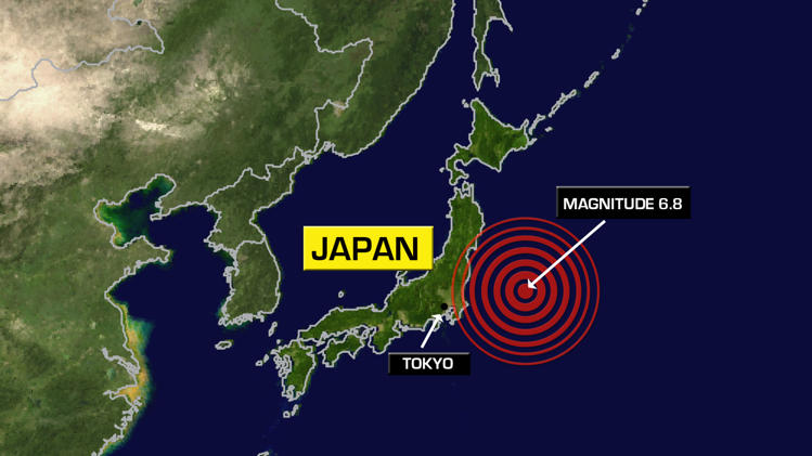
Seismologists said an earthquake that struck near Japan's shuttered Fukushima nuclear site early Saturday was an aftershock of the tremor that sparked 2011's deadly tsunami, and warned of more to come.

The strong 6.8-magnitude earthquake off the Pacific coast of northeastern Japan caused a minor tsunami in the early hours, though authorities lifted all weather warnings roughly two hours later.

Seismologist Yasuhiro Yoshida of the Japan Meteorological Agency said it was a delayed tectonic reaction to the 9.0-magnitude quake which left the Fukushima nuclear power plant in a meltdown crisis after the coast was ravaged by monster tidal waves in March 2011.

"There are fears that relatively large earthquakes will occasionally occur in the ocean area where aftershocks of the great earthquake continue," he said.

"The aftershock activity has been steadily declining on a long-term basis. But aftershocks, accompanied by tsunamis, will still occur."

The 2011 disaster killed more than 18,000 people.

Saturday's quake measured up to four on the Japanese scale of seven in terms of intensity, and Yoshida said there was a possibility aftershocks measuring a moderate three on that scale would occur in the next two weeks.

Comment: Readers can check out a short video of this earthquake here. Some additional updates on the Fukushima disaster can be found in these related articles:


Alarm Clock

USGS: Earthquake Magnitue 6.4 - 83km SSE of Pondaguitan, Philippines

Earthquake 6.4 Pondaguitan, Philippines
© USGS
Event Time
2014-07-14 07:59:58 UTC
2014-07-14 15:59:58 UTC+08:00 at epicente

Location
5.696°N 126.534°E depth=22.5km (14.0mi)

Nearby Cities
83km (52mi) SSE of Pondaguitan, Philippines
101km (63mi) ESE of Caburan, Philippines
129km (80mi) SE of Malita, Philippines
141km (88mi) ESE of Malapatan, Philippines
897km (557mi) WSW of Koror Town, Palau

Scientific data

Bizarro Earth

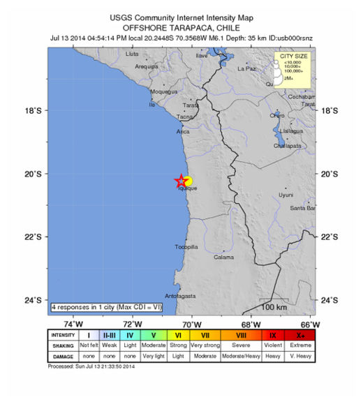
USGS: Earthquake Magnitude 6.1 - 22km W of Iquique, Chile

Iquique Quake_130714
© USGS
Event Time
2014-07-13 20:54:14 UTC
2014-07-13 16:54:14 UTC-04:00 at epicenter

Location
20.245°S 70.357°W depth=35.7km (22.2mi)

Nearby Cities
22km (14mi) W of Iquique, Chile
195km (121mi) S of Arica, Chile
205km (127mi) N of Tocopilla, Chile
248km (154mi) S of Tacna, Peru
475km (295mi) SSW of La Paz, Bolivia

Scientific Data

Bizarro Earth

Earthquake aftershocks continue to rattle SE Arizona

Image
Earthquake aftershocks of about magnitude (M) 3 continue to lightly rattle Duncan, Arizona and environs. The latest event, a M3.6 temblor, was felt 30 miles north in Morenci, Arizona. Aftershocks stem from the M5.2 earthquake that struck near Duncan, Arizona, (approximately 40 miles east of Safford) on the evening of June 28.

Since the M5.2 event, 14 felt aftershocks (from M2.8 to M3.9) have rattled the area around Duncan in southeastern Arizona and southwestern New Mexico. Like the main shock, these were shallow events occurring about 3 miles deep. The largest aftershock, at M3.9, occurred at 3:56 p.m. on July 3. Since yesterday, July 10, five felt earthquakes have been reported. The largest were M3.6 temblors at 2:59 p.m. on July 10, and 10:33 a.m. on July 11. Hundreds of smaller magnitude aftershocks - less than ~ M3.0 - have occurred since the onset of activity, and most went largely unfelt.

People in southeastern Arizona should be prepared for ongoing M3.0 to M4.0 earthquakes over the next weeks or even months. In the event of strong ground shaking, follow the "Drop, Cover and Hold On" convention used in earthquake-prone areas. For more information on what to do in the event of an earthquake, please visit the Great Arizona ShakeOut website.

Bizarro Earth

USGS: Earthquake Magnitude 4.1 - 43km WNW of Lordsburg, New Mexico

Image
© USGS
Event Time:
2014-07-12 02:48:58 UTC
2014-07-11 19:48:58 UTC-07:00 at epicenter

Location:
32.555°N 109.102°W depth=5.0km (3.1mi)

Nearby Cities:
43km (27mi) WNW of Lordsburg, New Mexico
80km (50mi) WSW of Silver City, New Mexico
130km (81mi) WNW of Deming, New Mexico
140km (87mi) NNE of Douglas, Arizona
294km (183mi) ESE of Phoenix, Arizona

Subsequent 3.0 aftershock

Scientific data

Comment: June 29, 2014: USGS: Earthquake Magnitude 5.2 - 89 miles NNE Douglas, Arizona


Alarm Clock

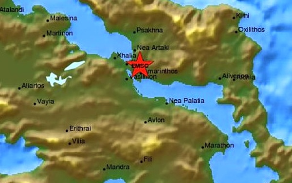
Earthquake Magnitude 4.3 in central Greece rattles Athens

Earthquake 4.3 hits central Greece
© Unknown
An earthquake of 4.3 magnitude on the Richter scale rattled Central Greece, today, July 11 at 12:46 pm. The areas where the earthquake was mostly felt were Chalkida and Eretria, while Athenians also felt its impact.

According to the Institute of Geodynamics the epicenter of the earthquake was in the city of Chalkida, Euboea, 54 kilometers north of Athens. The focal depth of the quake was detected at five kilometers.

Historically, earthquakes have caused widespread damage across central and southern Greece, the islands of the Ionian Sea, Crete, Cyprus, Sicily and other neighboring regions.

In January, a series of strong earthquakes on the western island of Kefalonia damaged hundreds of homes and injured more than a dozen people.