Earthquakes
S


Bizarro Earth

Magnitude 3.0 earthquake strikes near Manhattan Beach, CA

manhattan beach earthquake
A Los Angeles earthquake today 2014 has struck Manhattan Beach. The Los Angeles earthquake today July 30, 2014 began moments ago and was located near Hermosa Beach, El Segundo, Redondo Beach and Torrance. Damage assessment is pending.

Officials tell news that a 3.0 magnitude Los Angeles earthquake today struck just after 12:23 pm PST. The quake was shallow. Reps tell news that the quake started only six miles below sea level. As a result the quake could be felt across the vicinity. USGS indicates to news that the quake was six miles west of Manhattan Beach. It was six miles west of El Segundo. Reps tell news that the quake was six miles of Hermosa Beach, seven miles west of Redondo Beach. It was also west of Torrance, north of Palos Verdes, and northwest of Orange County.

Bizarro Earth

USGS: Earthquake Magnitude 6.3 - 19km SW of Juan Rodriguez Clara, Mexico

Juan Rodriguez Quake_290714
© USGS
Event Time
2014-07-29 10:46:15 UTC
2014-07-29 05:46:15 UTC-05:00 at epicenter

Location
17.842°N 95.524°W depth=95.1km (59.1mi)

Nearby Cities
19km (12mi) SW of Juan Rodriguez Clara, Mexico
60km (37mi) W of Sayula de Aleman, Mexico
62km (39mi) SSE of Carlos A. Carrillo, Mexico
65km (40mi) W of Acayucan, Mexico
418km (260mi) ESE of Mexico City, Mexico

Scientific Data

Road Cone

Increasing earthquakes in UK prompt rise in fracking fears

Image
An increasing number of earthquakes have been recorded in the UK, official figures show.
The highest level of detections in the last decade is set to be registered for 2014, with 100 earthquakes already recorded in the first three months of the year and 149 in total up until July.
This compares to 154 throughout 2013, 64 in 2006 and 111 reported in 2005, 2007 and 2011.

One small tremor, which centred on Jersey and Guernsey in the Channel Islands earlier this month. The quake had a magnitude measuring 4.2, making it the largest in the region for almost 90 years and the tremors were felt all along the south coast of England. The tremor was reported to have registered on British Geological Survey monitoring station equipment in Exeter, Devon.

Environmental activists fear the Government's desire to exploit shale gas reserves in rocks beneath the UK will cause small earthquakes. But ministers believe the technique used to tap into the potential supplies - known as fracking - will bring down energy bills and create thousands of jobs.

The UK earthquake data covering June 2004 to July 2014 was released to Parliament in response to a written question from Labour's Tom Greatrex.

Comment: Fracking - you are not important


Bizarro Earth

USGS: Earthquake Magnitude 6.0 - Northern Mid-Atlantic Ridge.

Mid Atlantic Quake_270714
© USGS
Event Time
2014-07-27 01:28:38 UTC
2014-07-26 22:28:38 UTC-03:00 at epicenter

Location

23.761°N 45.646°W depth=10.0km (6.2mi)

Nearby Cities
1811km (1125mi) ENE of Grande Anse, Guadeloupe
1832km (1138mi) ENE of Saint-Francois, Guadeloupe
1834km (1140mi) ENE of Le Moule, Guadeloupe
1842km (1145mi) ENE of Saint John's, Antigua and Barbuda
1843km (1145mi) ENE of Sainte-Anne, Guadeloupe

Scientific Data

Attention

Mother Earth gives a warning: Earthquakes occur in 3 areas of Alaska

Image
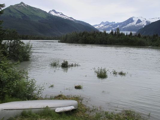
© Becky Bohrer APA view from the back porch of a home along View Drive in Juneau, Alaska, Friday, July 11, 2014. Earthquakes occurred in 3 different parts of Alaska Friday. Some shaking could be felt in Juneau.
Seismologists in Alaska say earthquakes have jolted three different parts of the state.

Several earthquakes, including a 5.9 magnitude one, occurred around the same location early Friday in southeast Alaska. The U.S. Geological Survey says light shaking was felt around Juneau, about 100 miles to the east.

An unrelated 4.3 magnitude earthquake was felt in Kodiak and no one reported feeling another unrelated 3.7 quake in Alaska's interior.

There are no immediate reports of damage.

Alarm Clock

Fracking fears after highest number of earthquakes in a decade hits the UK

Earthquake in Kent
© Getty ImagesFile image from Kent earthquake in 2007
An increasing number of earthquakes have been recorded in the UK, official figures show.

The highest level of detections in the last decade is set to be registered for 2014, with 100 earthquakes already recorded in the first three months of the year and 149 in total up until July.

This compares to 154 throughout 2013, 64 in 2006 and 111 reported in 2005, 2007 and 2011.

One small tremor, which centred on Jersey and Guernsey in the Channel Islands earlier this month.

The quake had a magnitude measuring 4.2, making it the largest in the region for almost 90 years and the tremors were felt all along the south coast of England.

The tremor was reported to have registered on British Geological Survey monitoring station equipment in Exeter, Devon.

Environmental activists fear the Government's desire to exploit shale gas reserves in rocks beneath the UK will cause small earthquakes.

But ministers believe the technique used to tap into the potential supplies - known as fracking - will bring down energy bills and create thousands of jobs.

Alarm Clock

Earthquakes are rising in Oklahoma - 2300 since January!

Oklahoma earthquake map
© USGS

Earthquakes used to be rare in Oklahoma, a handful per year or so. Not anymore. So far this year, the state has experienced some 2,300 earthquakes, according to the Oklahoma Geological Survey, an average of more than 11 per day.

Accordingly, the number of Oklahomans with earthquake insurance has jumped a startling 500 percent in less than three years, reports the Oklahoma Department of Insurance. While the cause of increased tremors in the Plains States remains under contention, residents, at the least, are preparing for the worst.

The state agency doesn't typically track the data and insurance companies don't report it, but "we were getting calls from around the country," says communications director Kerry Collins. So Collins called the state's top five homeowners insurance companies - accounting for more than 70 percent of the market - and estimated an average: In 2011, only 3 percent of the state's homeowners had an earthquake rider on their homeowners insurance policies; this year, 15 percent did.

Bizarro Earth

Why is Wal-Mart preparing for a major earthquake on The New Madrid Fault?

Madrid Fault Line_1
© End of American Dream
Buried in a Wall Street Journal article from about a week ago was a startling piece of information. According to a Wal-Mart executive, Wal-Mart "participated in an exercise to prepare for an earthquake on the New Madrid fault line" earlier this summer.

And officials at the U.S. Geological Survey have just released a report which indicates that they believe that the New Madrid fault zone has the "potential for larger and more powerful quakes than previously thought".

So should we be concerned? Do they know something that we don't? The USGS also says that the frequency of earthquakes in the central and eastern portions of the United States has quintupled over the past 30 years, and that significant earthquakes have started popping up in areas of the country that were once extremely quiet.

Along with the new report, the USGS released the following map...

Bizarro Earth

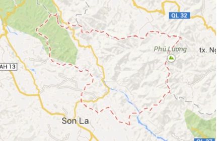
Province of Son La, Vietnam rocked by three earthquakes in one night

vietnam earthquake july 2014 map
Muong La District (in the red dashed line) in the northern Vietnamese province of Son La is seen in this Google Map screen capture.
The northern Vietnamese province of Son La experienced three earthquakes in a row on Saturday night, one of which reached a magnitude of 4.3 on the Richter scale, the Earthquake Information and Tsunami Warning Center said.

The three quakes struck Muong La District and their aftershocks were felt in Hanoi, 278 km away from Son La, according to the center under the Institute of Global Physics.

The first quake measuring magnitude 4.3 rocked the district at 7:14 pm, with its epicenter around eight kilometers underground.

The tremor lasted for about 30 seconds, shaking or throwing household furniture and tools to the ground, local residents said.

Many people rushed out of their houses during the earthquake, locals said.

Another quake happened in the same district at 8:20 pm, with a lower strength of magnitude 3.2. Its epicenter was the same as that of the previous one.

More than an hour later, the third earthquake, measuring magnitude 3.5, hit the locality at 9:42 pm, with its epicenter about seven kilometers underground.
Alarm Clock

USGS: Earthquake Magnitude 6.9 - 100km NNE of Ndoi Island, Fiji

Earthquake 6.9 Fiji
© USGS
Event Time
2014-07-21 14:54:40 UTC
2014-07-21 02:54:40 UTC-12:00 at epicenter

Location
19.780°S 178.441°W depth=616.1km (382.8mi)

Nearby Cities
100km (62mi) NNE of Ndoi Island, Fiji
369km (229mi) WNW of Nuku'alofa, Tonga
375km (233mi) ESE of Suva, Fiji
437km (272mi) SSE of Lambasa, Fiji
488km (303mi) ESE of Nadi, Fiji

Scientific data