Earthquakes
S


Alarm Clock

Earthquake Magnitude 6.2 - 50km WSW of Alim, Philippines

Earthquake  Philippines
© USGS
Event Time
2014-05-15 10:16:41 UTC
2014-05-15 18:16:41 UTC+08:00 at epicenter

Location
9.376°N 122.068°E depth=14.0km (8.7mi)

Nearby Cities
50km (31mi) WSW of Alim, Philippines
52km (32mi) WSW of Asia, Philippines
55km (34mi) SW of Sipalay, Philippines
80km (50mi) W of Bayawan, Philippines
590km (367mi) SSE of Manila, Philippines

Scientific data

Target

Best of the Web: Signs of change: Extreme weather, seismic activity, and meteor fireballs in April and early May 2014

Image
The uptick in earthquake activity continues all along the Ring of Fire. At the center of these changes, the United States dealt with "historic flooding" which was labelled a "one-in-500-year event"!

So much more has taken place over the last month or so than this video shows. Deluges continue to hit heavily populated areas. Be prepared for large-scale disasters in your area. It has and it will continue to worsen, whether we like or not. Stay safe and thanks for watching!


Alarm Clock

Another! Earthquake Magnitude 6.6 - 96km SSE of Ifalik, Micronesia

Earthquake 6.6 Micronesia
© USGS
Event Time
2014-05-15 08:16:34 UTC
2014-05-15 18:16:34 UTC+10:00 at epicenter

Location
6.509°N 144.899°E depth=10.0km (6.2mi)

Nearby Cities
96km (60mi) SSE of Ifalik, Micronesia
757km (470mi) W of Weno, Micronesia
767km (477mi) S of Mangilao Village, Guam
771km (479mi) S of Tamuning-Tumon-Harmon Village, Guam
770km (478mi) S of Hagatna, Guam

Scientific data

Comment: An aftershock or foreshock for something bigger? Another earthquake magnitude 6.1 happened just two hours earlier, which probably set the ball rolling in that area.
USGS: Earthquake Magnitude 6.1 - 99km SSE of Ifalik, Micronesia


Bizarro Earth

USGS: Earthquake Magnitude 6.1 - 99km SSE of Ifalik, Micronesia

Ifalik Quake_140514
© USGS
Event Time
2014-05-14 20:56:13 UTC
2014-05-15 06:56:13 UTC+10:00 at epicenter
Location
6.458°N 144.877°E depth=10.6km (6.6mi)

Nearby Cities
99km (62mi) SSE of Ifalik, Micronesia
760km (472mi) W of Weno, Micronesia
773km (480mi) S of Mangilao Village, Guam
777km (483mi) S of Tamuning-Tumon-Harmon Village, Guam
776km (482mi) S of Hagatna, Guam

Technical Details

Bacon

SOTT Focus: Are you prepping your diet?

Image
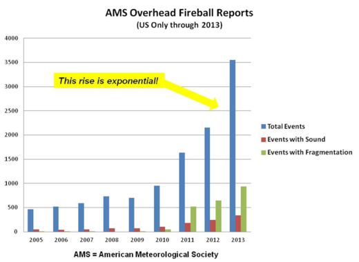
© sott.netAMS fireball reports through 2013
If you are a regular SOTT reader, you are certainly aware of the many areas that are building towards potential disaster - from environmental earth changes and overhead bombardment to growing Fascism and impending economic collapse. The good thing is that you do not need to pick one of these threats to begin preparing yourself, family and local community. The basic requirements for getting prepared apply to all these possible occurrences and more.

The prepping web community has grown in massive proportion to what it was just a decade ago. Blog, prepper and survivalist websites abound and many offer very good ideas that can be applied or adapted to your own situation and needs. But it is rare to see any of these resources address the question of prepping your diet. If prepping your diet confers significant advantages in a disaster/survival situation, then it will have a significant impact on your food storage strategy and what to look out for during an extended disaster.

The question is, does prepping your diet yield enough advantage to suggest changes to your current diet now? And if so, how does this impact your food storage and preparation plan? The answer to the former question, I think, is yes. An answer to the latter is below.
Alarm Clock

Earthquake Magnitude 6.0 - 11km W of Tecpan de Galeana, Mexico

Earthquake 6.0 in Mexico
© USGS
Event Time
2014-05-10 07:36:01 UTC
2014-05-10 02:36:01 UTC-05:00 at epicenter

Location

17.230°N 100.788°W depth=23.0km (14.3mi)

Nearby Cities
11km (7mi) W of Tecpan de Galeana, Mexico
37km (23mi) W of Atoyac de Alvarez, Mexico
59km (37mi) ESE of Petatlan, Mexico
79km (49mi) WNW of Coyuca de Benitez, Mexico
299km (186mi) SW of Mexico City, Mexico

Technical details

Comment:


Alarm Clock

Terror in Mexico as magnitude 6.4 earthquake sets off 'wave of panic'

Earthquake 6.4 in Mexico
© AFPWorkers in Mexico City watched as the quake caused building to sway
A strong earthquake of magnitude 6.4 has shaken parts of Mexico and causing building in the city to sway.

The BBC reports:
The US Geological Survey said it was centred near the town of Tecpan de Galeana in southern Guerrero state, about 190 miles (300km) south-west of Mexico City.

It was also felt in the resort city of Acapulco, the Associated Press says.

There are no reports of any damage or injuries but frightened office workers ran into the streets in the capital.

Bizarro Earth

USGS: Earthquake Magnitude 6.4 - 15km N of Tecpan de Galeana, Mexico

Tecpan Quake_080514
© USGS
Event Time
2014-05-08 17:00:17 UTC
2014-05-08 12:00:17 UTC-05:00 at epicenter

Location
17.385°N 100.656°W depth=23.9km (14.9mi)

Nearby Cities
15km (9mi) N of Tecpan de Galeana, Mexico
31km (19mi) NW of Atoyac de Alvarez, Mexico
66km (41mi) ESE of Petatlan, Mexico
73km (45mi) WNW of Coyuca de Benitez, Mexico
277km (172mi) SW of Mexico City, Mexico

Technical Details

Comment: See also this heat map for earthquake activity across the planet for the past year.


Map

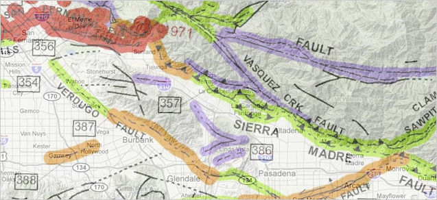
New California quake map reveals fault lines under homes, hotels, and schools

faultline map
The California Geological Survey's seismic map, as seen on its Web site, is expected to guide earthquake preparedness.
Nearly a century ago, as Hollywood rose from lemon groves, St. Stephen's Episcopal Church was built on a steep slope near Yucca Street.

But it was only this year that the pastor found out his church may lie atop an earthquake fault capable of tearing it in two.

In January, the California Geological Surveyissued preliminary fault maps for Los Angeles County for the first time in nearly two decades. One of the maps shows the approximate path of the Hollywood fault going directly under the church.

The mapped fault lines cut through more than 1,500 developed properties, according to a Times analysis of maps of the Hollywood fault and the Sierra Madre and Duarte faults in the northern San Gabriel Valley.

Alarm Clock

USGS: Earthquake Magnitude 6.1 - 96km SW of Panguna, Papua New Guinea

Earthquake 6.1 Papua New Guinea
© USGS
Event Time
2014-05-07 04:20:33 UTC
2014-05-07 14:20:33 UTC+10:00 at epicenter

Location
6.950°S 154.880°E depth=1.0km (0.6mi)

Nearby Cities
96km (60mi) SW of Panguna, Papua New Guinea
109km (68mi) SW of Arawa, Papua New Guinea
408km (254mi) SE of Kokopo, Papua New Guinea
546km (339mi) ESE of Kimbe, Papua New Guinea
622km (386mi) WNW of Honiara, Solomon Islands

Scientific details