Earth ChangesS


Fish

New bizarre-looking species breaks record for world's deepest fish

Image
© National News and PicturesAberdeen University researchers have set a new record for the deepest fish ever found (shown in red ring)
A never-before-seen fish has been caught on camera, setting a new depth record in the Pacific Ocean.

The world's deepest fish was captured on camera at depths of 8,145 meters (26,700 feet) in the Mariana Trench in the western Pacific Ocean. The newest discovery breaks a depth record set in 2008 by nearly 500 meters (1,640 feet).

The previously unknown creature, believed to be a snailfish, was filmed several times floating along the sea floor. It is a white translucent fish with an eel-like tail and wing-like fins.

Binoculars

Snowy owl sightings on the rise across the upper US

Image
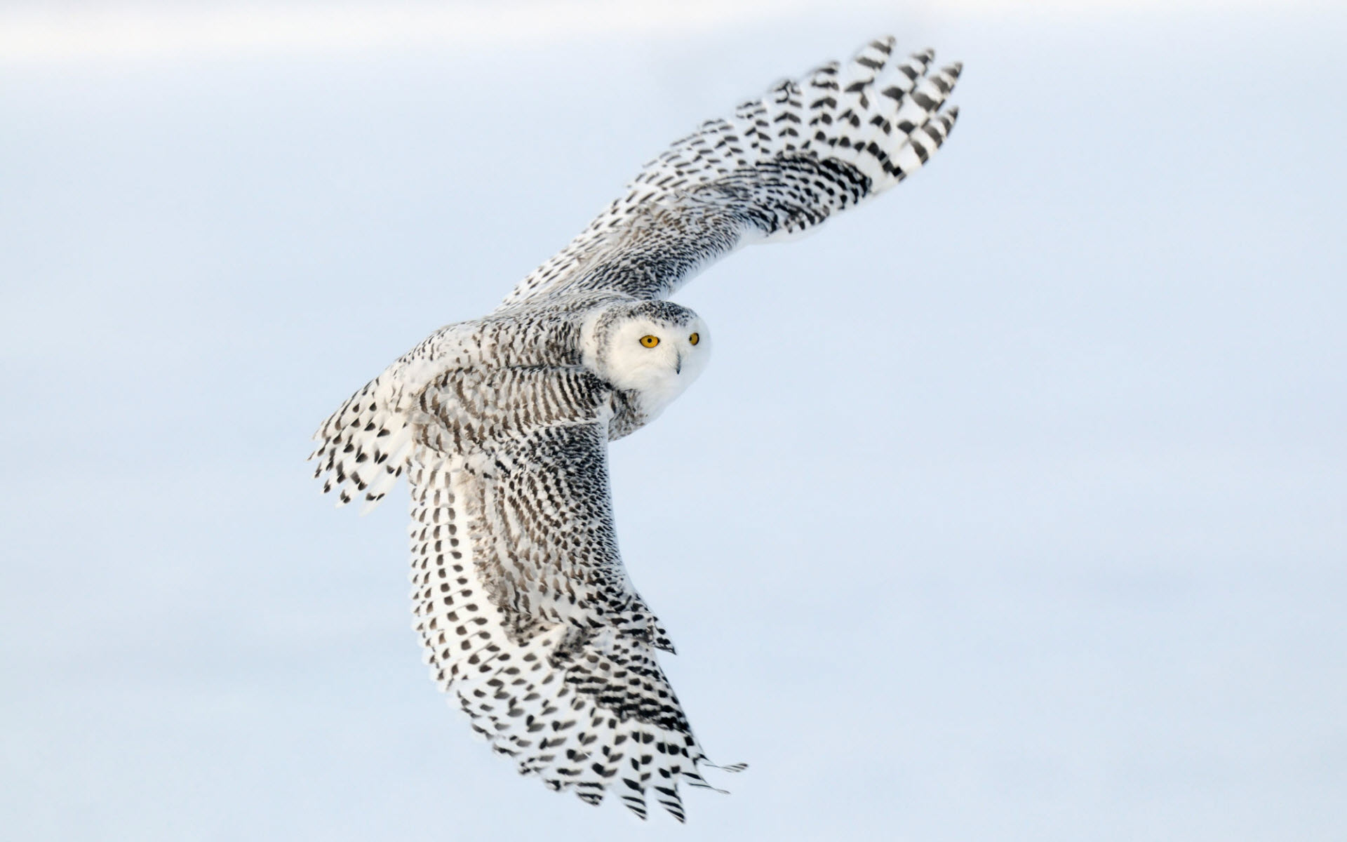
If you have a passion for birds or even if you're so-so about them, you're going to love this. All the indicators are present telling us this year is going to be witness to another snowy owl eruption across the upper United States. That means for us up here on the Range, too!

Last year, 2013-2014, we saw what was possibly the largest eruption of snowy owls during the last century. This year could be even better. There have already been 44 snowy owls reported in Minnesota alone.

There are different theories on why Snowy Owls leave the Arctic. Some believe that due to such great nesting success, a shortage of food forces the younger owls to leave the area in search of better hunting territories. Others believe the younger owls leave because they have not perfected their hunting skills yet and would not be able to survive competing among older, wiser owls. No matter the reason, what this really means to most of us is this will be a great winter to get out and see one of these beautiful visitors from the Arctic Tundra.

Binoculars

Rare Arctic gyrfalcon seen in Madbury, New Hampshire

Image
© Hanne & Jens Eriksen/VIREO
Gyrfalcon travels south from normal Arctic range

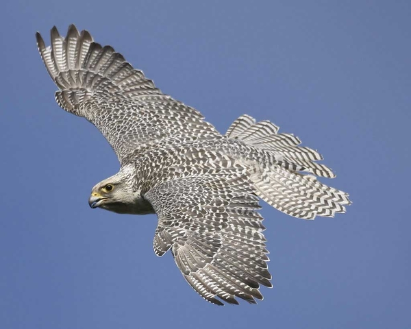
The largest of the falcons, a rare gyrfalcon, was seen in Madbury during the past week, according to the Audubon Society's rare bird alert.

Fast like a peregrine falcon and wearing a faint mustache, gyrfalcons live in the Arctic.

According to the Peregrine Fund, the birds of prey are very sensitive to changes in the environment.

The group said pesticides, loss of habitat or a decrease in prey can affect populations of gyrfalcons.

Snowflake Cold

30 die as cold wave hits north India

Image
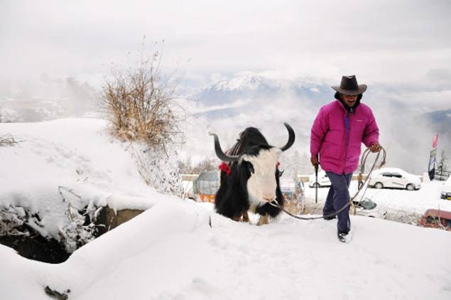
© AFP PhotoAn Indian local walks with his yak at Kufri, near Shimla, India, on December 13, 2014.
In some of the heaviest spells of snowfall Uttarakhand has seen in recent times, 30 people, according to the State Disaster Mitigation and Management Centre, have died in the hills in the last two days.

Himachal Pradesh also recorded heavy snowfall. The icy winds coming from these hill region swept Uttar Pradesh as well, leading to drop in temperatures. Lucknow was coldest in UP with minimum temperature 6.6 degrees Celsius.

People woke up to foggy morning in Lucknow. However, strong winds cleared sky by 9 am. These winds also kept mercury low during the day. The maximum temperature despite bright sunshine was 21.5 degrees Celsius, three degrees below normal. On Thursday, maximum and minimum temperature is expected to be around 21 and 7 degrees Celsius respectively. In the coming days, the Met officials said that the night temperatures would drop below five degrees Celsius.


Cloud Precipitation

US: Northwest storms bring heavy rain, strong winds through Christmas; blanket interior West with snow

Image
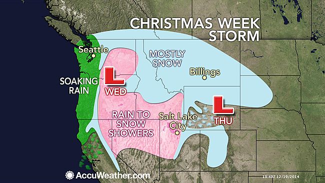
As the train of storms from the Pacific Ocean continues, rounds of rain and mountain snow will fall on areas from the Northwest to the Intermountain West and Rockies through Christmas Day.

A strong storm will affect the Northwest this weekend with gusty winds, heavy low-elevation rain and high-elevation snow.

A second storm will roll ashore on Tuesday with falling snow levels in the Northwest and heavy snow farther inland in the West.

Northwest Storm to Unleash Heavy Rain, Strong Winds This Weekend

According to AccuWeather Meteorologist Brian Lada, "The worst conditions this weekend will hit from the Cascades to the Pacific coast."

A general 4-8 inches (100 to 200 mm) of rain will fall from the upper Oregon coast to Washington's Olympic Peninsula and the southwestern part of Vancouver Island, British Columbia.

A general 2-4 inches of rain are forecast along Interstate 5, from Eugene and Portland, Oregon, to Seattle and Tacoma, Washington. Similar rainfall with locally higher amounts are possible along the west-facing slopes of the Cascades in Oregon and Washington.

Enough rain will fall to raise the risk of mudslides and flash and urban flooding. Small stream flooding is possible due to melting snow and heavy rain on the intermediate elevations of the Cascades.

Gusty winds will accompany the heavy rain, raising the potential for flight delays and localized power outages.

Comment: Superbomb winter storm predicted for Northeastern U.S. at Christmas


Cloud Precipitation

4 dead and 14,000 evacuated after flooding on the Thailand - Malaysia border

Image
© Bomba MalaysiaFlood evacuations in Kelantan, Malaysia.
Heavy rain and flooding has continued in southern Thailand and is now also affecting areas along the Thailand-Malaysian border. At least 4 states in Malaysia have suffered from severe flooding. Several southern provinces in Thailand have been under water for the last week.

Across the region a total of four people have been reported as killed in the floods and 14,000 people evacuated (12,000 in Malaysia). Two people remain missing in the floods in Thailand.


Windsock

Series of fast moving storm systems forecast for British Isles, Northern Europe

Image
A series of fast-moving storm systems will continue the theme of unsettled weather from Ireland and the United Kingdom through northern Europe through Christmas.

While no one particular storm will cause widespread damage or travel disruptions, each will produce showers, gusty winds and put temperatures on a roller coaster ride.

The showers will occasionally occur as or be mixed with snow in the higher terrain of the British Isles, as well as parts of Scandinavia and northeastern Europe.

Gusty winds will howl even when dry weather prevails, especially near the coastlines.

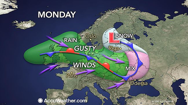
The next storm AccuWeather meteorologists expect to bring significant impacts will make its presents felt Sunday night and into Monday as low pressure develops in Scandinavia.

This storm system will first increase winds across the United Kingdom and Ireland on Sunday and Sunday night. Gusty winds will become more widespread on Monday as blustery conditions advance across much of northern and eastern Europe.

Not only will this bring system bring windy conditions, there will also be rainy conditions along the length of a frontal boundary across the region. Snow and ice is expected in eastern Europe as moisture pushes into colder air.

Comment: It's kind of interesting that Donbass is left out of these storms...


Bizarro Earth

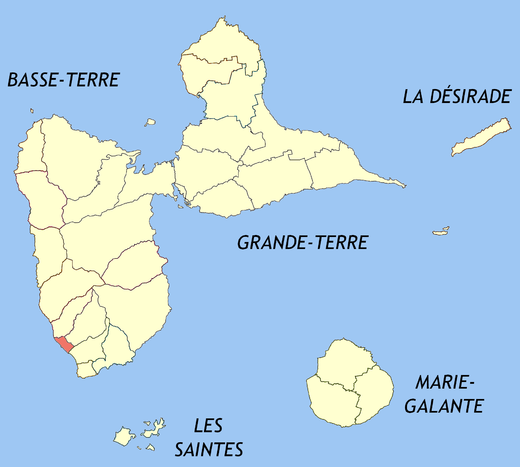
Magnitude 5.7 strikes the Basse-Terre island in Guadeloupe

basse terre, guadeloupe
A magnitude 5.7 earthquake struck the Basse-Terre island of the France's Guadeloupe archipelago in the Antilles on Friday, the U.S. Geological Survey said.

It said the quake's epicenter was located three miles (4.8 km)northwest of Lamentin on Basse-Terre and was 69.5 miles (111 km)deep. It struck at 3:49 p.m. (1949 GMT)

Arrow Up

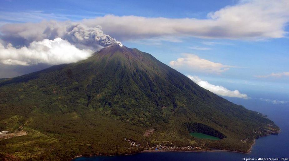
Mount Gamalama eruption sends ash and rocks 2 km into the sky, Indonesia

Image
Mount Gamalama in North Maluku province of Indonesia erupted at 13:41 UTC on Thursday, December 18, 2014, sending ash and rocks 2 km into the sky and forcing the authorities to close an airport and issue warnings to planes. Nine people were injured while running to escape the eruption. One person is still unaccounted for, authorities said.

Increased seismicity around the volcano was observed since 08:30 UTC. It then sharply increased at 13:09 UTC (22:09 local time), about 30 minutes before the eruption.

Evacuation orders are still not in place, however, a senior official from the disaster management agency in North Maluku province said the communities are ordered to be on alert of possible cool lava flowing in rivers as rain is frequent in recent days.

Comment: How does solar activity connect to seismic activity, and in turn contribute to global cooling? See Earth Changes and the Human Cosmic Connection for the interesting electromagnetic connect, of the way things are turning.


Cloud Precipitation

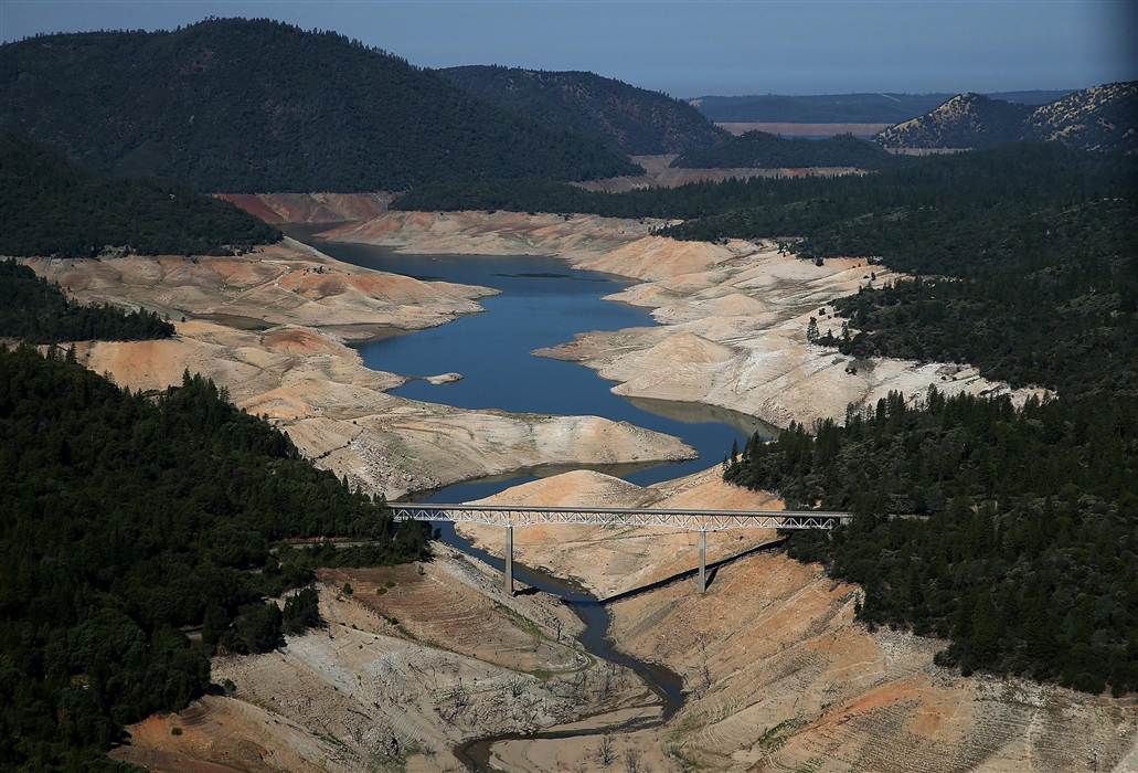
NASA experts: California needs 11 trillion gallons to end drought

Image
© Justin Sullivan / Getty Images
Rain has returned to California, taking pressure off of the immediate emergency of the ongoing drought via the help of several inches of recent rainfall.

But the Golden State loses about 4 trillion gallons per year, and would need roughly three times that amount to return to safe and normal levels.
"Recent rains are no reason to let up on our conservation efforts," Felicia Marcus, chair of the State Water Resources Control Board stated.
The same NASA experts who sounded the alarm over the drought's threat to the food supply are now warning that California needs some 11 trillion gallons of water to replenish to normal levels.
Eleven trillion gallons - that's the amount of water that NASA scientists say would be needed to replenish key California river basins in what they're calling the first-ever estimate of the water necessary to end an episode of drought. That 11 trillion gallons is the deficit in normal seasonal levels that NASA said a team found earlier this year in the Sacramento and San Joaquin river basins, using Gravity Recovery and Climate Experiment (GRACE) satellites. The GRACE data, presented Tuesday at the American Geophysical Union meeting in San Francisco, showed those river basins losing about 4 trillion gallons per year - more than state residents use annually, NASA said.

Comment: California drought spreading at unprecedented rate: