Storms
S

Bizarro Earth

New Zealand: 'Snow and ice everywhere' across south

Image
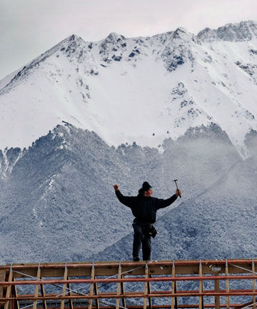
© BARRY HARCOURT/The Southland TimesON TOP OF THE WORLD: Te Anau builder Tony Rayfield thinks he still has the best job in the world regardless of the weather. With the Murchinson Mountains as a background, where in the world would you rather be.
Snow is falling intermittently in Invercargill while heavier dumps are beginning to affect roads and other services across the south.

However, most of the white stuff so far appears to be confined to the Fiordland region and the eastern coast of Southland and the Clutha district.

Warren Dickie, who farms on the Clinton-Matarua highway, said today's snow was not yet as bad as last year's big snow in September. ''Its just a bit cold and slippery, isn't it," he said.

Earlier this morning the snowfall had just been a light dusting on the ground but things changed quickly: "It's definitely ... a lot worse."

If the snow hung around as predicted for the next few days it could become more of a problem, he said.

Motorists appear to be heeding calls to be careful on southern roads, with no incidents reported to emergency services so far.

Te Anau police report a fresh cold snap this morning, with "snow and ice everywhere''.
Cloud Lightning

US, Idaho: Severe Thunderstorms Move Through Upper Snake River Plain

A severe thunderstorm warning remains in effect until 315 pm mdt for north central Bonneville county, At 248 pm mdt, national weather service doppler radar continued to indicate a severe thunderstorm with hail up to 1 inch in diameter. This storm was located near Iona, or 8 miles northeast of Ammon, moving northeast at 20 mph. Locations that could be affected include, rural northern Bonneville county, Precautionary/preparedness actions, Stay tuned to this broadcast for the latest updates and information. To report severe weather only, call 1 800 8 7 7 1 9 3 7.

Severe Thunderstorm Warning: The NWS in Pocatello has issued a severe thunderstorm warning for: central Bingham county in southeast Idaho, this includes the city of Blackfoot, Until 330 pm mdt. At 242 pm mdt, national weather service doppler radar indicated a severe thunderstorm capable of producing quarter size hail, and damaging winds in excess of 60 mph. This storm was located near Gibson, or near Blackfoot, and moving northeast at 15 mph. Locations that could be affected include, Blackfoot, Rose, Precautionary/preparedness actions, This is a dangerous storm. If you are in its path, prepare immediately for damaging winds, destructive hail, and deadly cloud to ground lightning. People outside should move to a shelter, preferably inside a strong building but away from windows. Stay tuned to this broadcast for the latest updates and information. To report severe weather only, call 1 800 8 7 7 1 9 3 7.

Bizarro Earth

Typhoon Ma-on Poses New Threat to Japan

Typhoon Ma-On
© Joint Typhoon Warning CenterSatellite image of Typhoon Ma-on at 10:00 a.m. ET.
Still in the midst of its long recovery from the earthquakes and tsunami of early March, Japan must now keep a watchful eye on typhoon Ma-on, rapidly intensifying in the western Pacific. The storm could impact the disaster-ravaged country early next week.

The Joint Typhoon Warning Center (JTWC) reports this morning that Ma-on, about 655 miles east-southeast of Iwo-Jima, has shown "steadily improving organization" over the past six hours, with convection "consolidating around the core" and the emergence of an eye.

The storm's current peak winds are 75 mph, equivalent to category 1 hurricane.

The storm is expected to remain within a tropical airmass with low wind shear and warm sea surface temperatures as it continues west through the northern Philippines Sea. Consequently, significant intensification is forecast over the next 72 hours, with peak winds predicted to reach 125 mph by Saturday morning, equivalent to a category 3 hurricane. JTWC cautions there is no reason to expect signficant weakening until the storm makes landfall.

Bizarro Earth

Chile: Rare Snow in Atacama Desert

Atacama Desert_1
© MODIS Rapid Response Team at NASA GSFCAcquired - July 7, 2011
Atacama Desert_2
© MODIS Rapid Response Team at NASA GSFCAcquired - July 7, 2011
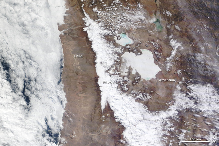
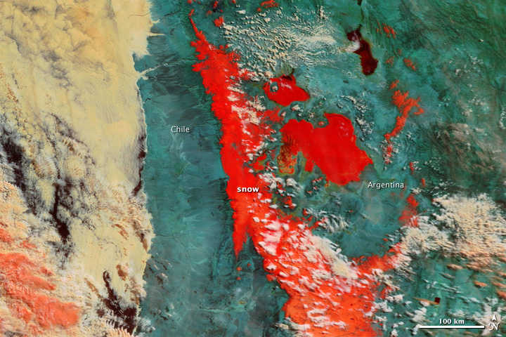
Ordinarily, the flashes of white in South America's Atacama Desert rise from salt pans. But on July 7, 2011, when the Moderate Resolution Imaging Spectroradiometer (MODIS) on NASA's Terra satellite acquired these images, the white came from a far rarer commodity: snow.

Starting on July 3 and lasting several days, a cold front dumped up to 80 centimeters of snow (32 inches) on the driest desert in the world, reported BBC News.

The images above show the largest snowfall the region has witnessed in a half-century. The top image provides a photo-like, natural color view of the snow. A few clouds hang over the white desert, marring the view slightly. The lower image, which includes both visible and infrared light, helps distinguish between snow and clouds. Snow is dark red, while clouds are lighter shades of orange and white.

Snowman

Thousands Stranded by Worst Snows in Bolivia for 20 Years

snow to the capital La Paz
© EPAA cold snap that brought fog and snow to the capital La Paz at the start of this month killed at least 35 people
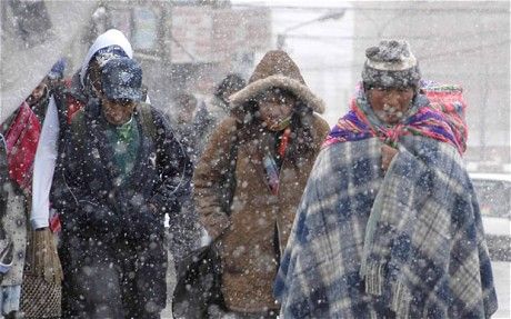
Thousands of people have been left stranded by the worst snow storms in Bolivia for 20 years.

President Evo Morales was reported to be considering declaring a state of emergency in the region of Potosi to mobilise the army and national guard.

Some 7,000 people belonging to farming families are in need of help in the region, according to officials.

More than 40,000 llamas and alpacas are also without food and farmers have lost their crops under a thick blanket of snow.

The snow has hit the remote highlands of Potosi, which lies in the south-west of the country and generally remains dry.

Cloud Lightning

Heavy rains strike north of Sweden

Image
© Per Eriksson/Scanpix
On Tuesday torrential rain flooded many roads in Sundsvall on the eastern coast of Sweden, a major power outage in the area was caused by the ensuing thunderstorms and a man in his sixties was taken to hospital after being struck by lightning.

Emergency services in Sundsvall are now putting all their efforts into draining the infrastructure. Head of local emergency services, Mats Granat, is counting on being busy all night - if the weather clears.

"If the rains continue we'll be working much longer," he told news agency TT.

So far the water level hasn't risen enough to pose a threat to the general public, according to Granat.

Cloud Lightning

Canada: Heavy rain causes flooding in Eckville, Alberta

Image
© CBCFlooding was caused by heavy rain that fell over the area Monday.
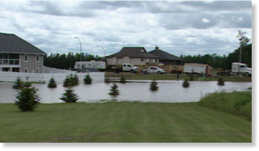
Heavy rains in central Alberta caused flooding in the town of Eckville Monday.

"People are just kind of dumbstruck," resident Sharon Walker said. "We have had washouts of roads. Some people have got 10 to 14 inches of water in their basements ... we've never seen anything like it."

Signs of flooding were everywhere Tuesday. Belongings from water-filled basements were out on lawns and there was a sinkhole on the side of a busy road.

Cloud Lightning

U.S.: Heavy Rain Hits Metro Area, Northeast Colorado

Image
Denver-- Torrential rain hit the Denver metro area Tuesday night, flooding streets and some buildings and prompting calls for water rescues.

There were numerous reports of cars stalled in high water, with people on the roofs of their cars, requiring rescue.

The monsoon moisture moved from the southwest to northeast across the metro area, pounding the downtown area starting just after 9 p.m.

Snowman

New Zealand: Severe Weather Warning Issued

A severe weather warning has been issued for more rain and snow that's set to batter the country today.

MetService is forecasting more heavy snow to nearly sea level in South Westland and Fiordland.

Snowfalls will affect all the main alpine passes and some roads in Southland and Otago.

Motorists are being advised to take extra care and check road conditions before travelling.

Heavy rain is also forecast for the Tararua Ranges today with 100 to 140 millimetres expected.

Warnings for severe gales in parts of Gisborne, Hawke's Bay and Wairarapa have been lifted.

Cloud Lightning

US: Storm caused power loss for 868,000 in Chicago area, service restored to 502,000

Image
© Terrence Antonio James/TribuneComEd workers repaired downed lines in the alley behind Ozark Avenue near Montrose Avenue in Norridge.
Commonwealth Edison Co. reported substantial progress in restoring power lost in Monday's storms but that still left hundreds of thousands without electricity in sweltering heat. The utility warned it could take days to get everyone back on line.

A record 868,000 homes and businesses were left without power by the storms that ripped through the area at 75 mph--the highest number of outages in 13 years. But by 6 a.m. that had been reduced to 369,200.

The majority were in the northern suburbs, where 207,300 were still in the dark and without air conditioning. About 71,000 were west of the city, 60,000 in Chicago and Maywood and 30,000 in the south suburbs.

In total, power had been restored to 502,600 customers, said ComEd spokeswoman Tony Hernandez.

The last time a storm left a comparable number of customers without power was in 1998, when 865,000 customers lost power in one storm.

ComEd spokesperson Tony Hernandez told WGN radio's John Williams Monday afternoon that "this is going to be one for the record books."