Storms
S


Snowman

Rare heavy snow snarls South African transport

Johannesburg - An unusually heavy snowfall that blanketed large parts of South Africa snarled transport on Tuesday, halting trains and leaving thousands of motorists stranded after highways closed.

The winter storm also brought high winds that played havoc with shipping and delayed air transport. The military dispatched a helicopter to pluck crew members from a cargo ship that ran aground off the east coast.

Parts of South Africa usually receive a dusting about once or twice a year but the storm that hit large parts of the eastern half of the country on Monday and Tuesday dumped up to 60 cms (2 feet) in some areas.

"Snow is not unheard of but it is usually not this extreme," said national weather service forecaster Karl Loots.

Transport authorities shut sections of major highways, including a heavily traveled route between Johannesburg and the main east coast city of Durban.

Bizarro Earth

Heavy Snow in Central Chile

Heavy Snow in Chile_1
© Earth Observatory, NASAAcquired 22nd July
Heavy Snow in Chile_2
© Earth Observatory, NASAAcquired 8th July
In what the interior minister described as a "white earthquake," heavy snow blanketed parts of Chile in July 2011. Snow was 2.3 meters (7.5 feet) deep in the city of Lonquimay, CNN reported. Santiago Times reported that some areas received four months' worth of snowfall in just four days.

The Moderate Resolution Imaging Spectroradiometer (MODIS) on NASA's Terra satellite captured these images of the region around Lonquimay on July 22, 2011 (top), and July 8, 2011 (bottom).

Using visible and infrared light, these images better distinguish between snow and clouds than a natural-color image would. Snow and ice are bright red or red-orange. Clouds range in color from off-white to peach. Vegetation is green.

Both images show winter conditions but, compared to the image from July 8, the scene from July 22 shows snow blanketing a significantly larger area around Lonquimay. On July 22, fog fills multiple valleys in between the snow-capped peaks.

Bizarro Earth

New Zealand: Wintry Blast Brings Worst Snow in Decade

Image
© Oliver StedingDovedale, looking towards Mt Arthur
The worst snow in at least 16 years brought parts of the country to a standstill today.

Heavy snow, sleet and high winds made conditions treacherous throughout the country and motorists were urged to avoid all but urgent travel.

The South Island was hardest hit with many roads closed, flights cancelled and people told to stay home.

A number of state highways around the country were closed, however many are now re-opening and will be reassessed in the morning.

For the full list of closures visit NZTA .

Wellington also recorded its lowest temperature ever and the polar storm is taking another swipe at the North Island tonight.

Arrow Up

Australia: Freak weather forces waterfall to flow UPWARDS in extreme 75mph winds

Extreme weather has been battering Australia this week.

Winds have become so strong that waterfalls have been blown upwards.

The strong winds, which are seriously affecting the waterways of southern Australia, have gone up to 75mph.

Image
© BBCExtreme: Winds in southern Australia are so strong that even waterfalls have been affected
Earlier this week, Sydney saw a month's worth of rain falling in just one day, according to the BBC.

Although the ferries which hundreds of commuters rely on have kept running, they have provided rocky rides for those brave enough to keep travelling on them.

Camera

NASA catches 3 tropical cyclones at 1 time

Nasa captures 3 cyclones
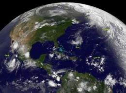
© NASA/NOAAIn this infrared image from the GOES-13 satellite on July 22 at 0845 UTC (4:45 a.m. EDT) Bret and Cindy are in the Atlantic, Low#1 (from a tropical wave) is in the Caribbean and Hurricane Dora is in the eastern Pacific, off the coast of Mexico.
It's not often that a satellite can capture an image of more than one tropical cyclone, but the GOES-13 satellite managed to get 3 tropical cyclones in two ocean basins in one image today. Bret and his "sister" Cindy are racing through the North Atlantic, while another area tries to develop far to their south. "Cousin" Dora is still a hurricane in the eastern Pacific.

An infrared image taken on July 22 at 0845 UTC (4:45 a.m. EDT), GOES-13 captured Tropical Depression Bret, Tropical Storm Cindy in the north Atlantic and low pressure area associated with a tropical wave in the Caribbean and Hurricane Dora is in the eastern Pacific, off the coast of Mexico. Cindy is 910 miles west-northwest of the Azores and Bret 295 miles northwest of Bermuda.

NASA's GOES Project issued an infrared image of both Bret and Cindy today from the GOES-13 satellite, which is operated by NOAA. The NASA GOES Project is housed at NASA's Goddard Space Flight Center in Greenbelt, Md. and uses GOES-13 data from NOAA to create images and animations.

Bret Being Battered

During the morning of July 22 Bret has sped up on his track through the north Atlantic and weakened. Bret is being battered by winds and cooler waters.

Bret was a tropical depression at 8 a.m. EDT on July 22, with maximum sustained winds near 35 mph (55 kmh). He was speeding to the northeast near 21 mph (33 kmh). By noon (EDT) Bret had degenerated into a low pressure area. His center was near 37.7N and 64.2 W, about 375 miles north of Bermuda.

Stop

Canada: Mud, rocks, trees slide onto Trans-Canada in British Columbia closing road for days

A large mudslide has closed the Trans-Canada Highway between Lake Louise, Alta. and Golden, B.C.

Parks Canada spokesman Mark Merchant says mud, rock and large trees poured onto the highway late Friday night near the spot where the road overlooks the Spiral Tunnels on the Canadian Pacific Railway.

Merchant says no one was injured, but provincial officials in B.C. say the highway will likely remain closed until Sunday afternoon.

He says the slide likely occurred because the area has received a lot of rain lately.

Traffic is being detoured south on Highway 93, which has reopened after being closed Friday due to a fatal crash that involved a fuel tanker.

Last month, a woman was injured when her car was caught in a mudslide on the Trans-Canada between Hope and Chilliwack.

Bizarro Earth

US: Heavy Rainstorms are Chicago's Latest Weather Nightmare

Heavy Rains in Chicago
© Robert Kozloff / Chicago TribuneA tow truck prepares to hook up a stranded car on the feeder ramp from I-90/94 to I-290 and the Congress Parkway downtown.
Those looking for some kind of a break from the heat of the last week got it overnight -- a rainstorm that dropped temperatures into the low 70s. But like the heat wave that preceded it, this rainstorm was anything but ordinary.

According to ChicagoWeatherCenter, the total rainfall at O'Hare -- 6.91 inches as of about 6:50 a.m. -- is the largest single-day rainfall since records began in 1871. The highest previous daily total was 6.64 inches on Sept. 12, 2008. And more rain is on the way.

There were rainfall totals as high as 7 inches as the storm moved noisily through the Chicago area after midnight, resulting in flash flood warnings from the National Weather Service and enough flooded roads and highways to make life miserable for passengers headed to or from O'Hare International Airport and make a mess of traffic overnight and into Saturday morning.

The north side got the brunt of the rain, with O'Hare International airport getting 5.53 inches in two hours, according to ChicagoWeathercenter.com. Some other totals of note reported by the Weather Center: 6.41 inches in Glenview, 5.4 inches in Arlington Heights and 5.49 inches in Elk Grove Village.

Cloud Lightning

Swollen rivers still threatening some parts of Czech Republic

CZ flood
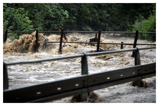
© ČTKPersistent rain on the night of 22 July lead to rise of Moravia river. The river burst its banks and disrupted transport between Hanušovice and Králíky
Prague - Swollen Czech rivers are still threatening some parts of north-east Bohemia and north Moravia, but meteorologists say rain should start abating tonight.

Yet, they have extended the warning against floods until 10:00 CEST on Saturday in the above parts of the Czech Republic.

Heavy rains started afflicting the country on Wednesday.

Some lower-category roads have been closed in the Liberec Region, north Bohemia, in the Kralovehradecky Region, east Bohemia, and in the Olomouc Region, north Moravia.

Some people who were evacuated in the regions could return to their homes today, while others preventively stay outside their homes.

Ambulance

Chinese D-train derails and falls from bridge

Dramatic pictures have just been released of a major train incident in the Wenzhou region of eastern China.

Image
© UnknownThe Chinese D train derailed with two of its carriages falling off a bridge.
The Chinese D train derailed with two of its carriages falling off a bridge after being crashed into by another train, reports suggest. The number of casualties, however, is still unknown, according to the official Xinhua news agency.

The train, travelling from Hangzhou to Wenzhou, went off the rails in eastern China's Zhejiang province around 8:30pm (1230 GMT), it reported, citing local firefighting sources.

It is thought to have come to a halt on the bridge near Wenzhou when its power failed following a lightning strike. A second train collided from behind, pushing carriages of the D train off the bridge.

Sun

SOTT Focus: Connecting the Dots: Cosmic Changes, Planetary Instability and Extreme Weather

Image
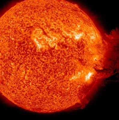
© NASA / SDOThe Solar Dynamics Observatory's view of the coronal mass ejection of June 7, 2011.
With Earth Changes now clearly happening and time pressing, the editors of Sott.net are faced with the urgency of catching up with an avalanche of significant news items and trying to make sense of things! Recent weather events have been unprecedented: both spring and early summer have been bizarre across the globe, to say the least.

You name the weather or geological type of phenomenon; someone in the world had it: volcanoes, earthquakes, torrential rain, floods, sinkholes, tornadoes, droughts, wildfires ... even summertime snow! Let's review them all as best as we can, starting from the top: the cosmic factor.
Solar Activity
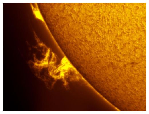
© Mike BormanImage Taken: Jun 4, 2011
Location: Evansville, Indiana, USA
Cosmic Changes Are Under Way

Changes on planet Earth comprise such a wide variety of phenomena, from extreme weather anomalies to volcanoes and earthquakes, so perhaps it's a good idea to zoom back and see if we can make sense of any changes in the cosmic climate that may be affecting us. Yes, we are aware that this approach goes against the sanctioned narrative claiming that these changes are caused by carbon-burning human beings living in an isolated bubble that can only grow warmer. But the pieces of the puzzle on the table point to a different, larger picture.

A huge central piece is our sun, which is not surprising, since this ongoing explosion in space is what brings order to our corner of the universe and to life to Earth. For the last couple of years the sun was expected to go into high activity in accordance with its usual 11-year sunspot cycle. But scientists were left scratching their heads as our local star remained quiet. Now it's giving off such a display of flares that it has NASA scientists going 'ooh and ahh'.