Secret HistoryS


Info

5,000-year-old Stone Age map unearthed in Denmark

Stone Age maps
© National MuseumMore and more Stone Age maps are turning up on Bornholm.
A mysterious stone found in a ditch on Bornholm by archaeology students during the summer has proven to be a 5,000 years old map.

According to the magazine Skalk, the stone was discovered during archaeological excavation work at the Neolithic shrine Vasagård.

The stone has been studied by researchers at the National Museum of Denmark.

Unlike previous and similar findings, archaeologist and senior researcher at the National Museum, Flemming Kaul, is reasonably certain that the stone does not show the sun and the sun's rays, but displays the topographic details of a piece of nature on the island as it appeared between the years 2700 and 2900 BC.

Ritual stones

Kaul called the stone "without parallel". In recent years, excavations at Vasagård have turned up several stones inscribed with rectangular patterns filled with different rows of lines and shading.

"Some of the lines may be reproductions of ears of corn or plants with leaves," said Kaul.

"These are not accidental scratches," said Kaul. "We see the stones as types of maps showing different kinds of fields."

The recent find was not complete. It is made up of two pieces and one piece is still missing. Archaeologists believe the stones were used in Stone Age rituals.

Igloo

Secret Nazi Arctic military base code-named 'Treasure Hunter' discovered

Nazi Military Base Code-named ‘Treasure Hunter’
© Ruptly
A secret Nazi-era tactical base has been discovered by Russian researchers on the island of Alexandra Land in the Arctic Circle, located 620 miles from the North Pole.

The site, code-named "Schatzgraber" or "Treasure Hunter" was built by Nazis in 1942 - a year after Hitler invaded Russia - and was primarily used as a tactical weather station that was crucial in planning the strategic movements of Nazi troops, warships and submarines.

"Before it was only known from written sources, but now we also have real proof," said Evgeny Ermolov, a senior researcher at the Russian Arctic National Park, in a statement. The written source Ermolov referenced is the book "Wettertrupp Haudegen," published in 1954, and written in German.

Magnify

18th century Scottish 'Ossian' epic likely borrowed heavily from Irish mythology

Ossian, Scottish bard
© Public DomainA painting of Ossian, the third-century Scottish bard, by Nicolai Abildgaard.
In 1760, Scottish poet James Macpherson published a volume of poems he claimed to have translated from the Gaelic works of a third-century Scottish bard named Ossian. The poems were an enormous hit and a major inspiration to the nascent Romantic period in literature and art.

They may also have been fakes — or, at least, far less authentic than Macpherson claimed. Early critics, including English poet Samuel Johnson, pointed out the poems' similarities to Irish mythology and that Macpherson never produced any ancient documents indicating the origin of the works.

Now, a new analysis of the relationships among the characters in the "Ossian" poems suggests they share more in common with their Irish cousins than their author would have liked to admit. The social structure of the world of "Ossian" is more similar to that seen in Irish mythology and less similar to that seen in the Homeric epics that Macpherson touted as being similar to the Scottish work.

Comment: Related articles:


Dig

Ancient Roman battlefield uncovered in Jerusalem

archeological dig
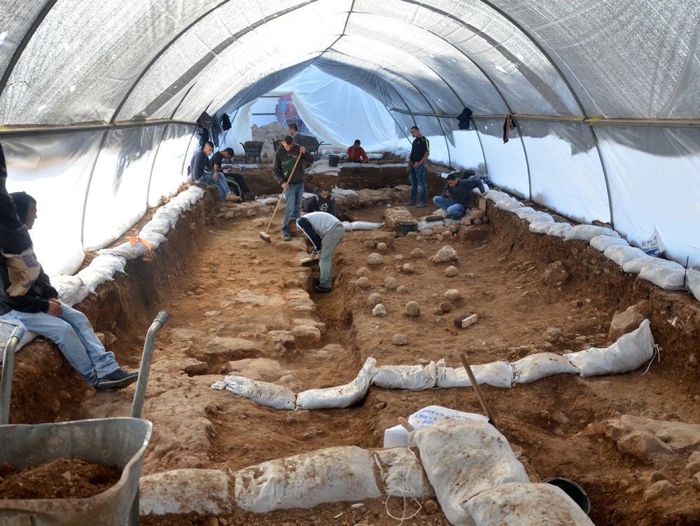
© Yoli Shwartz, courtesy of the Israel Antiquities AuthorityThe excavations, which took place in Jerusalem Russian Compound, revealed a thick wall, believed to be the city's "Third Wall," described by the historian Josephus.
Archaeologists say they've found evidence of a battlefield from the Roman emperor Titus' siege of Jerusalem in A.D. 70.

Recent excavations revealed a section of the so-called "Third Wall" of Jerusalem that Titus' army breached on its way to conquering the city, according to the Israel Antiquities Authority (IAA).

Outside the wall, the archaeologists found that the ground was littered with large ballista stones (stones used as projectiles with a type of crossbow) and sling stones, suggesting that this area had been under heavy fire from Roman siege engines.

These archaeological remains were unearthed last winter at the site where the campus of the Bezalel Academy of Arts and Design is to be built, in an area of the city that is known today as the Russian Compound, IAA officials said.

Comment: Related articles:


Roses

Remembered: The day Aberfan shocked the world 50 years ago

Aberfan in 1966
Aberfan in 1966
The Aberfan Disaster of 50 years ago should never have happened, according to a former UNM official.

At 9.15am on Friday morning, a minute's silence was held to remember Aberfan.

Here, Jamie Bowman gets Ted McKay's view of the shocking incident half a century ago...

Today marks the 50th anniversary of the Aberfan Disaster.

It started as a normal school day at Pant-glas Junior School but in the five minutes between 9.15 and 9.20 am, tragedy struck when thousands of tons of coal waste burst down the mountainside and engulfed the school.

The tragedy claimed 144 lives, including 116 schoolchildren.

Archaeology

Australian farmer's dinosaur find may change theory of how dinosaurs spread around the world

dinosaur discovery australia
© David Mercado / Reuters The discovery sheds new light on how dinosaurs travelled the world.
The discovery of a giant dino skeleton by a farmer in Australia has led to new theories as to how and why they spread around the world. Researchers have theorized that the 15-meter-long sauropod made its way to Australia thanks to global warming.

Savannasaurus elliottorum, named after David Elliott, the sheep farmer who discovered its remains, was unearthed in 2005 in Winton, Queensland, but has taken ten years to study, with the latest research published this week in Scientific Reports.

Boat

Controversy surrounds artifacts on Azores Islands: Evidence of advanced ancient seafarers?

Holes in rock
© Antoneita CostaMysterious marks found in rocks in the Azores archipelago, Portugal.
The Azores archipelago is about 1,000 miles off the coast of Europe, about a third of the way to North America across the Atlantic. The islands belong to Portugal, and the official historical record has long held that they were uninhabited until Portuguese expeditions colonized them in the 15th century. But a controversial alternative theory is gaining ground.

Some experts, including the president of the Portuguese Association of Archaeological Research, Nuno Ribeiro, have said rock art and the remnants of human-made structures on the islands suggest the Azores were occupied by humans thousands of years ago.

This assertion is controversial because it has been used to support a theory that a trade route existed between the Phoenicians, the Norse, and the New World—long before contact with the New World is conventionally thought to have taken place. We will explore this theory and its connection to the Azores in more detail later.

Comment: Related articles:


Question

How did a chunk of India and Eurasia disappear?

Earth
© ixpert / Shutterstock.comWhat happened to half of the mass of India and Eurasia?
Half of the mass of Eurasia and India is missing, new research finds, and may have been swallowed up by the Earth's mantle.

If so, that would be a surprise, as geoscientists thought that continental crust — the kind that makes up major landmasses — was too buoyant to dive down into the mantle, the pliable middle layer of the planet upon which the crust rides.

"It used to be thought that the mantle and the crust interacted only in a relatively minor way," study researcher David Rowley, a geoscientist at the University of Chicago, said in a statement. "This work suggests that, at least in certain circumstances, that's not true."

Comment: Related articles:


Archaeology

Ain Ghazal: Studying the earliest farmers

fossil early farmers
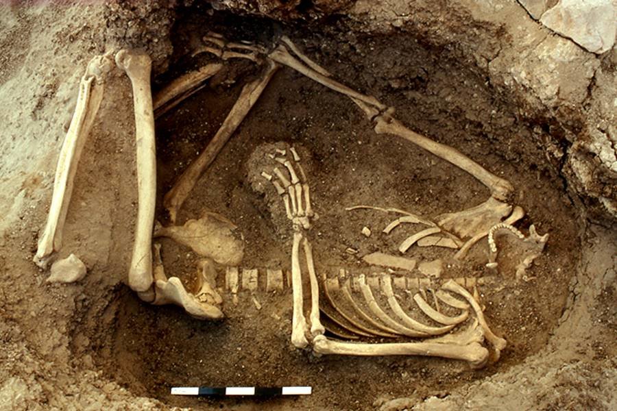
© C. Blair/The Ain Ghazal Archaeological ProjectA fossilized skeleton of a human who was buried beneath a floor in a family home in Ain Ghazal, a 10,000-year-old farming village in Jordan.
Beneath a rocky slope in central Jordan lie the remains of a 10,000-year-old village called Ain Ghazal, whose inhabitants lived in stone houses with timber roof beams, the walls and floors gleaming with white plaster.
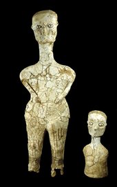
Ain Ghazal ancient farming figurines
© P. Dorrell and S. Laidlaw/The Ain Ghazal Archaeological Project Two of the sculptures recovered at Ain Ghazal. They likely represent mythical ancestors to whom the plastered skulls were directed.
Hundreds of people living there worshiped in circular shrines and made haunting, wide-eyed sculptures that stood three feet high. They buried their cherished dead under the floors of their houses, decapitating the bodies in order to decorate the skulls.

But as fascinating as this culture was, something else about Ain Ghazal intrigues archaeologists more: It was one of the first farming villages to have emerged after the dawn of agriculture.

Around the settlement, Ain Ghazal farmers raised barley, wheat, chickpeas and lentils. Other villagers would leave for months at a time to herd sheep and goats in the surrounding hills.

Sites like Ain Ghazal provide a glimpse of one of the most important transitions in human history: the moment that people domesticated plants and animals, settled down, and began to produce the kind of society in which most of us live today.

But for all that sites like Ain Ghazal have taught archaeologists, they are still grappling with enormous questions. Who exactly were the first farmers? How did agriculture, a cornerstone of civilization itself, spread to other parts of the world?
Pyramid

Use of cosmic rays, space particles, reveal two 'secret chambers' in Egypt's Great Pyramid

pyramid cut-away
© ScanPyramids
Two secret chambers have been discovered in Egypt's 4,500-year-old Great Pyramid of Giza. Researchers confirmed they had found the mysterious cavities after scanning the centuries old tomb using revolutionary radiography equipment.

The Scan Pyramids project made the latest discovery after being able to demonstrate the efficiency of non-evasive Muons technology at the Bent Pyramid in Dahshour this May. Last year thermal scanning identified a major anomaly in the Great Pyramid, sparking a debate over whether there was a long-running network of tunnels hidden away inside.

But now the mystery has been answered as the Ministry of Antiquities announced on Thursday that 'two anomalies' were found in the pyramid built under King Khufu. They are now looking to conduct further tests on the 146m-high monument to determine their function, nature and size.

The pyramid, also known as the Pyramid of Khufu, named after the son of Phara oh Snefru, is considered one of the seven wonders of the ancient world. It has three known chambers, and like other pyramids in Egypt was intended as a pharaoh's tomb.
pyramid workers muons
© ScanPyramidsMuons emulsion plate setup in Khufus lower chamber.