Earthquakes
S


Bizarro Earth

Indonesia - Earthquake Magnitude 6.2 - Sulawesi

Indon Quake_240411
© USGSEarthquake Location
Date-Time:
Sunday, April 24, 2011 at 23:07:51 UTC

Monday, April 25, 2011 at 07:07:51 AM at epicenter

Time of Earthquake in other Time Zones

Location:
4.593°S, 122.808°E

Depth:
9.4 km (5.8 miles)

Region:
SULAWESI, INDONESIA

Distances:
75 km (46 miles) SSE of Kendari, Sulawesi, Indonesia

99 km (61 miles) NNE of Baubau, Sulawesi, Indonesia

534 km (331 miles) NW of DILI, Timor-Leste

1240 km (770 miles) NW of DARWIN, Northern Territory, Australia

Info

US: Preliminary magnitude-3.1 quake rumbles in Arkansas

The U.S. Geological Survey has recorded a preliminary magnitude-3.1 earthquake near Greenbrier in central Arkansas.

The quake was recorded at 7:20 a.m. Saturday three miles northeast of Greenbrier - about 35 miles north of Little Rock. Greenbrier police say there weren't any reports of injuries or damage. A magnitude-2.2 quake was recorded in the same area 20 minutes later.

Seismologists have recorded some 1,000 quakes in the region since September - including a magnitude 4.7 in February that was the strongest earthquake recorded in Arkansas in 35 years.

The latest quakes come after two natural gas exploration companies - Oklahoma City-based Chesapeake Energy Corp. and Clarita Operating LLC - agreed this week to keep two nearby injection wells shutdown as researchers study whether the operations are linked to the quakes.

Source: The Associated Press

Attention

US, California: 3.6 Earthquake Shakes East County

Quake Centered Near Vallecito, About 16 Miles East-Southeast Of Julian

A magnitude 3.6 earthquake shook eastern San Diego County on Saturday, according to automated seismographs and computers operated by the U.S. Geological Survey.

The quake was centered near the village of Vallecito, about 16 miles east-southeast of Julian, or about 50 miles east-northeast of downtown San Diego. It hit at 1:49 p.m.

The quake was in a seismically-active valley along the Great Southern Overland Stage Route Of 1849, a bit northwest of the cluster of thousands of aftershocks from last year's magnitude 7.2 Mexicali earthquake.

Bizarro Earth

Earthquake with Magnitude of 6.0 Hits Off Coast of Honshu, Japan

A powerful 6.0-magnitude tremor has stuck near the eastern coast of Japan's Honshu Island.

Image
The US Geological Survey website says the earthquake occurred at 10:12 am GMT on Saturday at a depth of 38.9km, 160km east of the city of Morioka. There have been no immediate reports of damage or casualties. The latest tremor comes along the series of aftershocks that followed the March 11 mega earthquake and ensuing tsunami that devastated Japan's northeast.

Bizarro Earth

Solomon Islands - Earthquake Magnitude 6.9

Solomon Quake_230411
© USGSEarthquake Location
Date-Time:
Saturday, April 23, 2011 at 04:16:55 UTC

Saturday, April 23, 2011 at 03:16:55 PM at epicenter

Time of Earthquake in other Time Zones

Location:
10.349°S, 161.233°E

Depth:
81.6 km (50.7 miles)

Region:
SOLOMON ISLANDS

Distances:
76 km (47 miles) W of Kira Kira, San Cristobal, Solomon Isl.

173 km (107 miles) SE of HONIARA, Guadalcanal, Solomon Islands

184 km (114 miles) SSE of Auki, Malaita, Solomon Islands

2084 km (1294 miles) NNE of BRISBANE, Queensland, Australia

Alarm Clock

Earth opening up: Video of ground shifting during 3.7 earthquake in Japan April 10


Evil Rays

Philippines: Intensity 3 quake 'with rumbling sounds' felt near Taal Volcano

Intensity 3 and Intensity 1 volcanic earthquakes were felt in two villages near Taal Volcano yesterday, the Philippine Institute of Volcanology and Seismology (Phivolcs) reported.

Phivolcs said in its April 20 bulletin that a total of 13 volcanic earthquakes were detected in Taal Volcano during the past 24 hours.

One of the quakes, which occured at 3:15 p.m. Tuesday, was felt at Intensity 3 in Barnagay Calauit and Intensity 1 in Barangay Pira-Piraso.

Phivolcs said that the tremor was accompanied by rumbling sounds.

In the Phivolcs Earthquake Intensity Scale, Intensity 3 is classified as "weak", but it is felt by many people indoors specially in upper floors of buildings.

Info

Japan Earthquake Triggered Smaller Quakes Around World

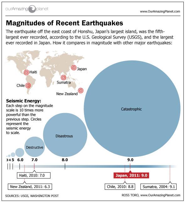
Magnitude of Recent Earthquakes
© OurAmazingPlanet
The earthquake that launched a series of disasters in Japan in March triggered micro-quakes and tremors around the world, scientists find.

The catastrophic magnitude 9.0 earthquake that struck off the coast of the Tohoku region of Japan March 11 set off tremors mostly in places of past seismic activity, including southwest Japan, Taiwan, the Aleutians and mainland Alaska, Vancouver Island in Canada, Washington state, Oregon, central California and the central United States. It was unlikely that any of these events exceeded magnitude 3.

Researchers noted, however, that temblors also were detected in Cuba. "Seismologists had never seen tremor in Cuba, so this is an exciting new observation," Justin Rubinstein, a seismologist with the U.S. Geological Survey at Menlo Park, Calif., told OurAmazingPlanet.

Part of the excitement of the find is the insight it could add into the inner workings of earthquakes.

"Studying long-range triggering may help us to better understand the underlying physics of how earthquakes start," explained seismologist Zhigang Peng at the Georgia Institute of Technology in Atlanta.
Bizarro Earth

Earthquake Magnitude 6.6 - South of the Kermadec Islands

Kermadec Quake_180411
© USGSEarthquake Location.
Date-Time:
Monday, April 18, 2011 at 13:03:03 UTC

Tuesday, April 19, 2011 at 01:03:03 AM at epicenter

Time of Earthquake in other Time Zones

Location:
34.349°S, 179.854°E

Depth:
90.7 km (56.4 miles) set by location program

Region:
SOUTH OF THE KERMADEC ISLANDS

Distances:
323 km (200 miles) SSW of L'Esperance Rock, Kermadec Islands

527 km (327 miles) NNE of Gisborne, New Zealand

552 km (342 miles) ENE of Auckland, New Zealand

910 km (565 miles) NNE of WELLINGTON, New Zealand

Arrow Up

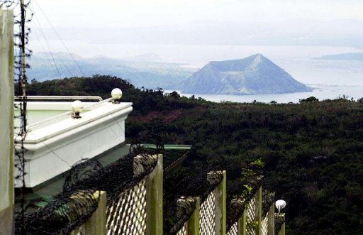
Philippines: 20 volcanic quakes in Taal recorded in last 24 hours

taal
© Agence France-PresseWater in the crater of Taal is reportedly heating up while the volcano's emissions of carbon dioxide have risen
The Philippine Institute of Volcanology and Seismology (PHIVOLCS) maintained the Alert Level 2 hoisted over Taal Volcano, as 20 volcanic earthquakes were recorded during the past 24 hours.

Alert 2 status means present activities could eventually lead to an eruption, according to Phivolcs.

Phivolcs said there was a noticeable increase in seismic activity of the volcano. Water temperature at the Main Crater Lake also slightly increased from 29.8°C to 30.1°C.

Phivolcs advised the public to keep away from the Main Crater, Daang Kastila Trail and Mt. Tabaro because sudden hazardous steam-driven explosions may occur and high concentrations of toxic gases may accumulate.