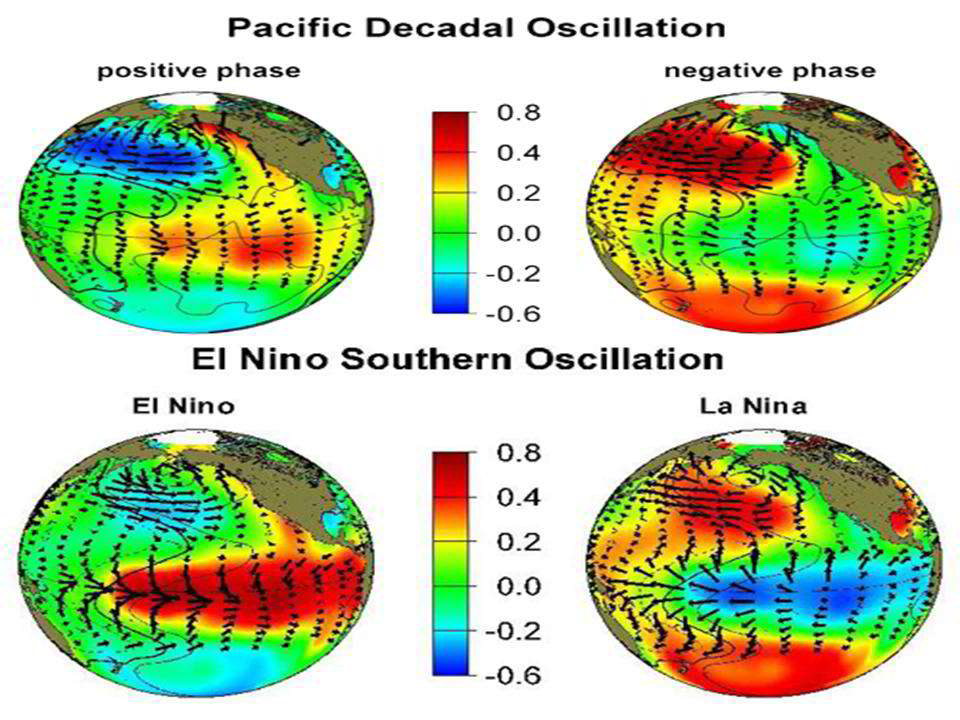
The PDO has a major influence on Alaskan and for that matter global temperatures. The positive phase favors more El Ninos and a stronger Aleutian low and warm water in the north Pacific off the Alaskan coast. The negative phase more La Ninas and cold eastern Gulf of Alaska waters. Note the strong similarity of the positive phase with El Nino and the negative with La Nina.
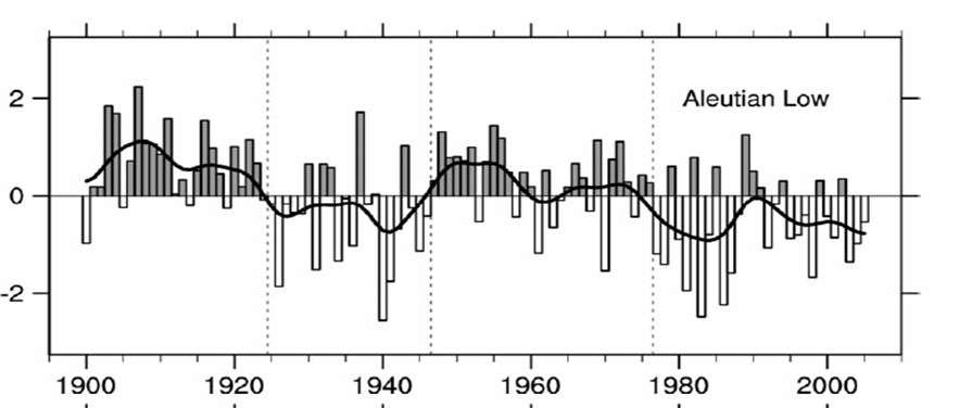
See the Aleutian low pressure anomalies below. Note the sudden shifts in 1947 when PDO turned negative and 1977 when it turned positive.
The combination of a stronger Aleutian low and warm water off the coast leads to warmer temperatures in Alaska in the positive PDO phase and a weakened or displaced Aleutian low, colder water, and colder Alaskan temperatures in the negative phase.
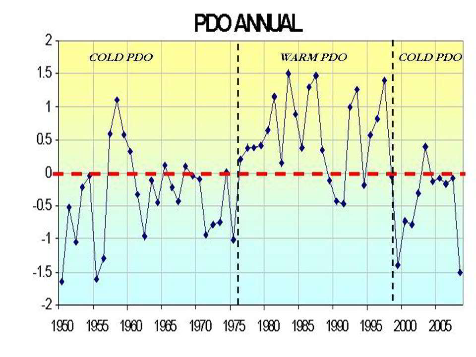
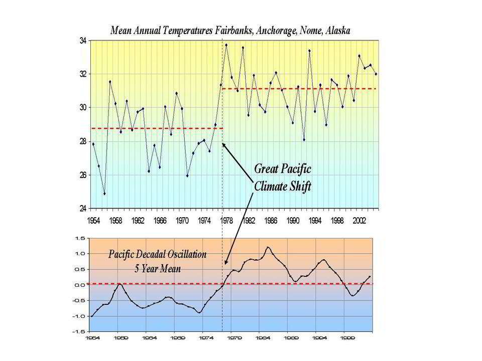
Here is a plot of the annual mean PDO. Note the phase changes in 1947 and 1977.
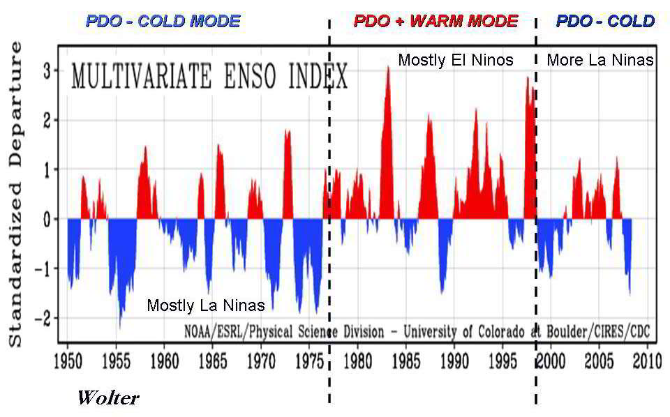
You can see above the rapid flip of the PDO in 1977 to positive and back in the last 1990s and especially in 2007 to negative. See how that compares to the ENSO (El Nino and La Nina) state below.
The PDO flip in 1977 from negative which correlated with frequent La Ninas (shown by the blue spikes) gave way to frequent El Ninos (red spikes) More frequent La Ninas and weaker El Ninos followed the recent decline.
.
In Alaska, the sudden Great Pacific Climate Shift in 1977 led to a step-ladder warming.
We will update this after the annual 2008 temperatures become available in January.
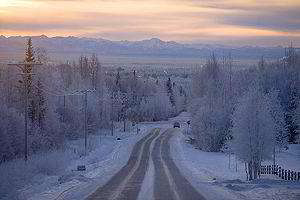
The decline since 1999 and especially since 2007 has led to rapid cooling and heavy snows. Alyeska, Alaska picked up 826" (nearly 70 feet) of snow last snow season. This was followed by an extremely cold summer and a sudden advance of Alaskan Glaciers for the first time in 250 years.
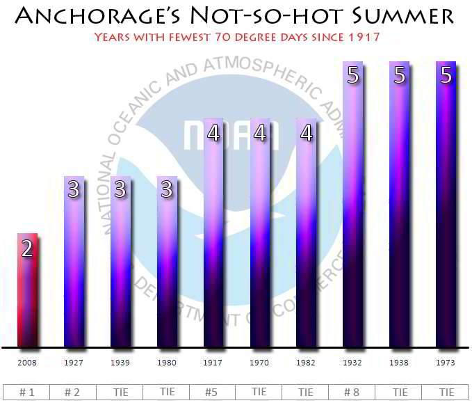
Anchorage reached 65F only 16 times this past summer, tying the record set in 1970 for least 65F days. It broke the record for least 70F days with only 2.
With heavy winter snows and a cold spring and summer, the ice did not melt as much as usual - the result was a net increase or advance in glaciers.
As Michael Asher reported October 16, 2008 in Daily Tech, Alaskan Glaciers Grow for First Time in 250 years: A bitterly cold Alaskan summer has had surprising results. For the first time in the area's recorded history, area glaciers have begun to expand, rather than shrink. Summer temperatures, which were some 3 degrees below average, allowed record levels of winter snow to remain much longer, leading to the increase in glacial mass.
"In mid-June, I was surprised to see snow still at sea level in Prince William Sound", said glaciologist Bruce Molnia. "In general, the weather this summer was the worst I have seen in at least 20 years".
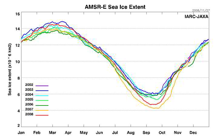
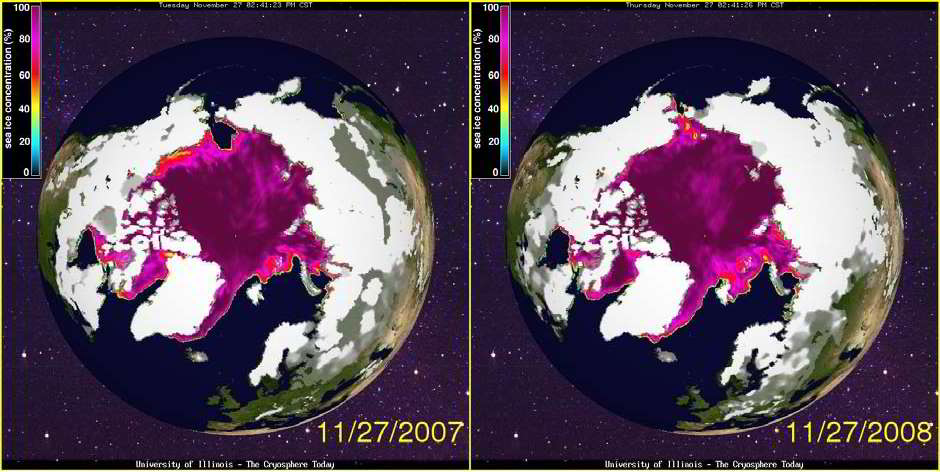
Earlier on September 3, 2008, Michael reported in Arctic Sees Massive Gain in Ice Coverage that data from the National Snow and Ice Center (NSIDC) has indicated a dramatic increase in sea ice extent in the Arctic regions. The growth over the past year covers an area of 700,000 square kilometers: an amount twice the size the nation of Germany. With the Arctic melting season over for 2008, ice cover will continue to increase until melting begins anew next spring.
The data is for August 2008 and indicates a total sea ice area of six million square kilometers. Ice extent for the same month in 2007 covered 5.3 million square kilometers, a historic low. Earlier this year, media accounts were rife with predictions that this year would again see a new record. Instead, the Arctic has seen a gain of about thirteen percent.
And the cold continued this fall. This is part of a statement from the National Weather Service in Fairbanks on November 24th.
Public Information StatementFinally note the current arctic ice exceeds 2007 in both the eastern and western areas.
National Weather Service Fairbanks AK
421 PM AKST Mon Nov 24 2008
...A COLD START TO WINTER THIS YEAR AT FAIRBANKS...
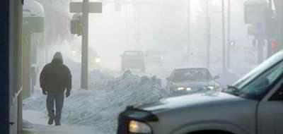
October ended up as the 4th coldest in the last 104 years of weather record at Fairbanks. The total of 13 days with a low temperature below zero was the most since 1965.
November has also been much colder than average. Through yesterday ...the average temperatures of -2.3 degrees was 7.3 degrees below the 30-year average. It has been the 8th coldest November in the last 50 years. There have been a total of 20 days So far this month where the temperature has fallen below zero...which is already above the average of 18 days for the entire month.
The high temperature so far this month of 17 above was observed on the 11th. The low temperature of 25 below was observed on the 19th. End


I recently completed a university essay on the Pacific Decadal Oscillation, and I had to comment on past and future trends. It was clear to me, after looking at all the raw data, that one of the main causes of Earth's warmer temperatures over the last few decades was likely to be the warm phase of the PDO. It was also clear that Earth has just entered the cold phase of the PDO and this will last another 25 years or so. A very sharp drop occurred in the PDO only in the last few years, much sharper and greater than previous drops from the warm to cold phase. The Earth will not be doing any more warming for the next 20 years, and this current cold phase could be a particularly severe one. The recent spate of record-low temperatures and early snowfalls all around the world are suggestive of this.