Storms
S


Attention

Study: Super typhoon may flood a third of Tokyo

Tokyo, Japan
© BLOOMBERGA Tokyo Metropolitan Government report says 99 percent of Sumida Ward, where Tokyo Skytree is located, will be flooded if a supertyphoon hits the capital.
One-third of central Tokyo could be left under water and nearly four million people affected if a super typhoon were to strike Japan's capital, causing storm surges, a new study has warned.

The Tokyo metropolitan government unveiled on Friday its first estimate of the capital city's vulnerability to damage from typhoon-related high tidal waves, as risks of storm damage continue to rise globally.

According to the report, 212 sq km, or one third of Tokyo's central area, could be inundated to a maximum depth of 10m if a super typhoon creates high tidal waves.

A severe event of this type would be estimated to affect as many as 3.95 million people in the city, flooding business and entertainment districts as well as major railway stations, the local government said.

Tokyo has a population of 13.7 million people.

Windsock

Jelawat rapidly intensified into the first super typhoon of 2018

Super Typhoon Jelawat
© NASA/NOAA Suomi NPP/VIIRSSuper Typhoon Jelawat on March 30, 2018.
Typhoon Jelawat not only became the first typhoon of 2018, but then exploded into a Category 4 super typhoon, a relative rarity this early in the calendar.

Jelawat was first categorized as a tropical depression last Saturday, then strengthened to become the year's first typhoon Thursday afternoon, U.S. time.

Over the western Pacific Ocean north of the equator and west of the International Dateline, tropical cyclones are called typhoons when they strengthen to the equivalent of a hurricane.

But Jelawat, named for a Malaysian word for a freshwater fish, wasn't content to merely slide across the typhoon threshold.

Because of a west-to-east cocoon of lower wind shear, strong outflow winds aloft providing ventilation for thunderstorms, and some warmer than average ocean water, Jelawat rapidly intensified, gaining 70 knots (roughly 80 mph) of intensity in just 24 hours, becoming the equivalent of a Category 4 super typhoon by Friday morning, U.S. time.

Tornado2

Amazed residents film tornado touch-down in Var, France

tornado france var
© Bryan Frt/ Facebook
Life on our planet is clearly undergoing serious changes that can be seen in the shifting seasons and also in individual, unusual but increasingly common events.

January in France saw every major weather station record above average rainfall with 30 departments on alert for flooding, areas of Paris underwater as the Seine swelled to 6 metres, and mountain areas saw unexpectedly high snowfall. Then, in 24 hours in February, France saw a magnitude 4.8 earthquake and a fireball.

So in keeping with what is actually a worldwide trend, today 31st March, La Crau residents in the Var region in France, saw Spring's grey skies birth a tornado which touched down early afternoon, and thankfully the locals whipped out their recording devices to capture the phenomenon. An investigation is under way to determine the strength of the winds.

Comment: See Also:


Cloud Precipitation

A taste of the future? Hailstorms damage crops in several districts of Bihar, India

crop damage
Crop damage
Hailstorm accompanied by moderate rain lashed several districts in north Bihar on Friday.

Certain blocks of Sitamarhi, Madhubani, East and West Champaran, Araria, Kishanganj and Darbhanga witnessed hailstorm along with thundershowers during the day. Thunder squalls occurred in some districts in north Bihar, such as Purnia and Motihari.

Satellite observations of Doppler Weather Radar on Friday morning showed severe thunderstorm, hailstorm, lightning accompanied with light to moderate rain and winds at a speed of 60-80km per hour lashing Bettiah, Motihari, Sheohar, Sitamarhi, Madhubani, Darbhanga, Samastipur, Muzaffarpur, Purnia, Katihar, Madhepura, Supaul, Araria and Saharsa from 10am to 1pm on Friday.

The snow pellets during the hailstorm caused damage to standing wheat, sugarcane and maize crops in many north Bihar districts. Litchi and mango blossoms also sustained damages.

Comment: Similar events in Asia have also occurred recently in Nepal, Bhutan and Bangladesh.


Cloud Lightning

Lightning kills two, crops damaged by large hailstones in Rangpur, Bangladesh

A significant number of crops were devastated by the storm
© Ariful Islam/Dhaka TribuneAriful Islam/Dhaka Tribune
A huge storm and hailstones passed over Rangpur city and surrounding districts on Friday afternoon, resulting in at least two deaths and significant damage to crops. The most affected areas were different areas of Pirganj and Mithapukur upazila.

Meanwhile, one person was killed in Sylhet as a result of flying debris in the storm.

In Rangpur, at least two people have died, and about 50 others were injured, while significant damage was done to trees and households .The two deceased were Shamim of Badarganj and Nayan Miah of Taraganj, both day labourers who were struck by lightning.

Besides Rangpur city, the tornado hit several parts of Gangachhara, Pirganj, Mithapukur, and Taraganj upazilas.

Comment: On the same day in Pakistan a lighting bolt killed 3 farmers in Pabna while a man died after being hit on the 23rd of March in Netrakona. Elsewhere across the world an angler was fatally struck in Malayasia on the 24th and a woman died in India on the 22nd due to the same cause.


Cloud Precipitation

Hailstorm damages crop and property in Bhutan

Stock photo
Hail and windstorm in several gewogs in Sarpang yesterday afternoon damaged crops and property.

No casualties or injuries have been reported so far.

Preliminary disaster assessment report found damage in three gewogs of Shompangkha, Dekiling and Gakidling. Shompangkha is the most affected gewog.

As of late evening yesterday, assessment could be carried out in just half of Darjaythang and Kencholing chiwogs. Roofs of six houses were blown away and over 10 poultry farms were damaged. The disaster left over 400 poultry birds, six goats, and a cow dead.

Cloud Precipitation

Massive storm with hail the size of tennis balls damages crops, house roofs in Nepal

Piles of hailstones deposited in Matsari area of Durga Bhagawati Rural Municipality, in Rautahat district, on Friday, March 30, 2018.
© Prabhat Kumar JhaPiles of hailstones deposited in Matsari area of Durga Bhagawati Rural Municipality, in Rautahat district, on Friday, March 30, 2018.
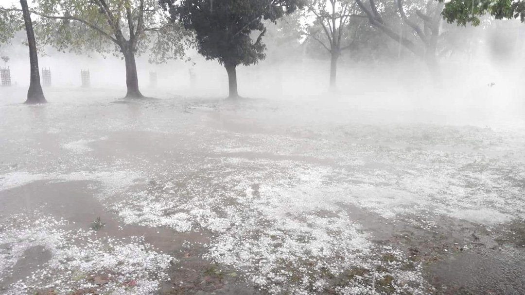
A massive hailstorm has severely damaged crops and tiled roofs of more than 200 houses in around a score of villages in Rautahat today.

Most of the hailstones, as big as lawn tennis balls, weighing about 500 grammes hit the villages of the municipalities — Madhav Narayan, Devahi Gonahi, Gadhimai, Gajura, Rajdevi and Garuda — including Durga Bhagawati Rural Municipality for 35 minutes since 8:00 am on Friday morning.

Cloud Lightning

Adapt 2030 Ice Age Report: Elements of the Grand Solar Minimum easily explained

deep snow
A graphic to describe all of the changes we as a planetary civilization will see unfold over the next 7 years culminating in reduced global crop production. We collectively need to start the conversation so we can begin to find solutions. What to expect: 1. Declining Solar Output 2. Weakening Magnetosphere 3.Out of season storms 4. Massive rain events, rivers from the sky 5.Huge and ever increasing size of hailstones 6. Increased meteor sightings and rattling explosions 7. Jet Streams wandering far out of their normal zones 8. Increases in cosmic rays which will trigger more eruptions and create thicker cloud layers 9. REDUCTION IN GLOBAL GRAIN YIELDS


Cloud Lightning

NOAA's weather satellites film upward striking lightning and thundersnow in March

weather
NOAA's weather satellites are always watching, which means they capture all of the wildest, weirdest weather shots that occur on planet Earth. Check out the round up of the wildest shots and videos NOAA released:

Upward striking lightning

The vast majority of lightning discharges around the world are "in-cloud" or "cloud-to-cloud" and the ones we see appear to strike from cloud to ground. However, "upward propagating discharges," or upside-down lightning strikes, are possible, but extremely rare. When this happens, the lightning strike begins at the ground and then travels up towards the clouds. High-speed camera studies have shown upward lightning flashes to be more common than once thought.


Cloud Precipitation

More floods in Queensland, Australia after torrential rain from ex Cyclone Nora - 2 feet in 24 hours recorded

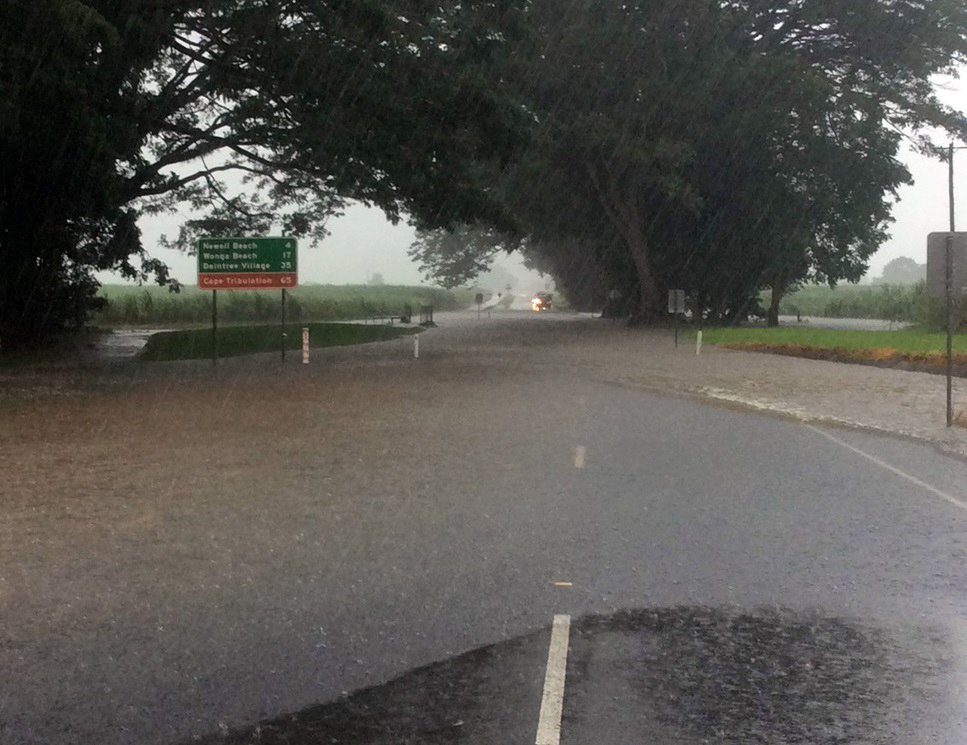
Flooded road in northern Queensland, Australia, after torrential rain from ex Tropical Cyclone Nora, March 2018.
© QFESFlooded road in northern Queensland, Australia, after torrential rain from ex Tropical Cyclone Nora, March 2018.
Torrential rainfall from ex Tropical Cyclone Nora in northern Queensland, Australia caused rivers to reach some of the highest levels seen in almost 20 years. Emergency services were called on to rescue over 40 people from the flooding. This is the fifth serious flood event in the state in the last few weeks.

Port Douglas recorded 593 mm of rain in 24 hours to 26 March, 2018. Abingdon Downs Station recorded 405 mm of rain in 24 hours the next day.

During Monday, Australia's Bureau of Meteorology (BoM) said they observed rainfall in excess of 100 mm per hour to the west of Cairns and near Tully.