Earthquakes
Tuesday, September 07, 2010 at 16:13:32 UTC
Wednesday, September 08, 2010 at 04:13:32 AM at epicenter
Time of Earthquake in other Time Zones
Location:
15.869°S, 179.261°W
Depth:
10 km (6.2 miles) set by location program
Region:
FIJI REGION
Distances:
155 km (100 miles) ENE of Lambasa, Vanua Levu, Fiji
210 km (130 miles) SW of Sigave, Ile Futuna, Wallis and Futuna
350 km (220 miles) NE of SUVA, Viti Levu, Fiji
2400 km (1490 miles) NNE of Auckland, New Zealand
The magnitude 7.1 quake on Friday night in New Zealand was larger than the one that killed 200,000 people in Haiti this year and appeared to have opened a new fault line.
Mark Quigley, a geology professor leading a team investigating the cause of the quake, said: "One side of the earth has lurched to the right."
Much of the centre of Christchurch remained sealed off and under curfew for a second night on Sunday.
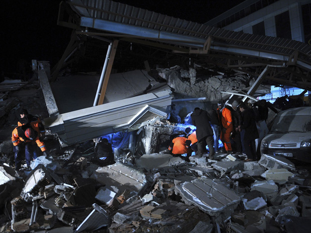
More than 500 buildings have been badly damaged. Two men were seriously hurt by falling masonry but there have been no reports of deaths.
Saturday, September 04, 2010 at 08:52:01 UTC
Saturday, September 04, 2010 at 09:52:01 PM at epicenter
Time of Earthquake in other Time Zones
Location:
17.270°S, 174.000°W
Depth:
37.1 km (23.1 miles)
Region:
TONGA
Distances:
150 km (90 miles) S of Hihifo, Tonga
155 km (95 miles) N of Neiafu, Tonga
445 km (275 miles) NNE of NUKU'ALOFA, Tonga
2430 km (1510 miles) NNE of Auckland, New Zealand

The quake at a depth of 34 kilometres (21.1 miles) struck six kilometres (four miles) from Christchurch at 04:05 am (1635 GMT Friday), the USGS said.
Although many people with minor injuries sought treatment, hospitals said there were no reports of any serious injuries although doctors were on standby because of the intensity of the quake and the damage to buildings.
The quake struck at a depth of 16.1 kilometres some 30 kilometres northwest of Christchurch at 4:35 a.m. (11:35 a.m. ET Friday), the USGS said.
Roads in the seaside suburbs were packed with cars as residents moved inland but there were no tsunami alerts issued. A swarm of aftershocks were ongoing and police said damage was widespread throughout Christchurch, with electricity supplies cut to about half of the city of about 340,000.
Sewer lines were damaged and residents were being urged to conserve water supplies. Local resident Colleen Simpson told the Stuff website that many people had run out onto the streets in fear, while the mobile phone network was failing.
"Oh my God. There is a row of shops completely demolished right in front of me," Simpson said. Kevin O'Hanlon, from Mairehau in Christchurch, said: "Just unbelievable. I was awake to go to work and then just heard this massive noise and, boom, it was like the house got hit. It just started shaking. I've never felt anything like it."
Friday, September 03, 2010 at 11:16:08 UTC
Friday, September 03, 2010 at 02:16:08 AM at epicenter
Time of Earthquake in other Time Zones
Location:
51.785°N, 176.010°W
Depth:
50.8 km (31.6 miles)
Region:
ANDREANOF ISLANDS, ALEUTIAN IS., ALASKA
Distances:
45 km (30 miles) E of Adak, Alaska
130 km (80 miles) WSW of Atka, Alaska
1905 km (1180 miles) WSW of Anchorage, Alaska
2715 km (1680 miles) W of JUNEAU, Alaska
According to the volcanic observatory run by Colombia's Geology and Mining authority Ingeominas, the several tremors are related to the activity of the volcano and an eruption is likely within days or weeks.
The quakes took place in the area surrounding the active volcano just outside the city of Pasto.
Ingeominas says it continues to be alert to the volcanic phenomena and will report changes.
The Galeras volcano erupted last in January, after which 8,000 people were forced to evacuate.
Tuesday, August 24, 2010 at 02:12:00 UTC
Monday, August 23, 2010 at 07:12:00 PM at epicenter
Time of Earthquake in other Time Zones
Location:
18.867°N, 107.327°W
Depth:
10 km (6.2 miles) set by location program
Region:
OFF THE COAST OF JALISCO, MEXICO
Distances:
290 km (180 miles) SW of Puerto Vallarta, Jalisco, Mexico
315 km (195 miles) W of Manzanillo, Colima, Mexico
325 km (205 miles) WSW of Autlan, Jalisco, Mexico
855 km (530 miles) W of MEXICO CITY, D.F., Mexico
Friday, August 20, 2010 at 17:56:19 UTC
Saturday, August 21, 2010 at 03:56:19 AM at epicenter
Time of Earthquake in other Time Zones
Location:
6.559°S, 154.088°E
Depth:
50.9 km (31.6 miles)
Region:
BOUGAINVILLE REGION, PAPUA NEW GUINEA
Distances:
165 km (105 miles) WSW of Arawa, Bougainville, PNG
260 km (160 miles) SSE of Taron, New Ireland, PNG
825 km (510 miles) ENE of PORT MORESBY, Papua New Guinea
2325 km (1440 miles) N of BRISBANE, Queensland, Australia
Wednesday, August 18, 2010 at 16:28:20 UTC
Thursday, August 19, 2010 at 02:28:20 AM at epicenter
Time of Earthquake in other Time Zones
Location:
12.210°N, 141.456°E
Depth:
43.1 km (26.8 miles)
Region:
MARIANA ISLANDS REGION
Distances:
385 km (240 miles) WSW of HAGATNA, Guam
460 km (285 miles) WSW of Rota, Northern Mariana Islands
470 km (290 miles) NE of Yap, Micronesia
565 km (350 miles) SW of SAIPAN, Northern Mariana Islands

Stunned survivors search for bodies amongst the debris left by the tsanami on Lalomanu Beach in September 2009.
Simultaneous earthquakes, with one hiding the other, are unusual "and almost certainly increased the size of the tsunami and its destructiveness on some Tongan islands," New Zealand's GNS Science said in a statement.
Global earthquake readings initially indicated a single large "normal faulting" quake of magnitude 8.0 had occurred, producing an extensional motion while the tsunami waves indicated a "thrust" event with compressional movement.
The scientists said they were unable to reconcile the conflicting data until six weeks after the event when measurements from a small Tongan island showed there must have been two large earthquakes.
Their findings appear this week as the cover story in the prestigious science publication Nature.
"This is a rare phenomenon," lead author John Beavan, a geophysicist at GNS Science, said Wednesday.