Earthquakes
S


Bizarro Earth

Aftershocks may portend major Philippine earthquake

Philippine Trench
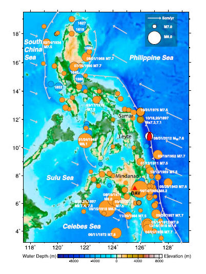
© Ye, et al./GRL Vol. 39A diagram of the Philippine Trench showing historic large earthquakes of magnitude 7.0 or great, as well as the motions of tectonic plates.
Aftershocks shook the Philippines for more than two weeks after a magnitude-7.6 quake rocked the region on Aug. 31, 2012. A team of seismologists monitoring the aftershocks and plotting their whereabouts noticed an odd pattern.

"Typically, if you locate aftershocks they sort of outline the fault that ruptures. This time they didn't," said Thorne Lay, a geophysicist at the University of California, Santa Cruz who was part of the team. "Instead they were shallower and had very different fault geometries."

The 7.6 quake happened at a fault within the Philippine Sea Plate, which is subducting beneath the Philippine Microplate. Some of the unusual aftershocks were so called "intraplate" ruptures, like the original quake, but happened at a shallower depth.

And others of the unusual aftershocks were located west of the epicenter, within the Philippine Trench itself, where the plate is subducting. These are called interplate aftershocks because they happen at the boundary between two plates.

That segment of the trench hasn't seen a major earthquake in at least 400 years, but the shocks may be a sign that the plate boundary is linked to the intraplate rupture and that it is building up strain in preparation for a big one.

No one will know until GPS equipment is installed and scientists collect more data, Lay said.

Bizarro Earth

USGS: Earthquake Magnitude 6.0 - 101km W of Craig, Alaska

Image
© USGS
Event Time:
2013-01-31 09:53:43 UTC
2013-01-31 00:53:43 UTC-09:00 at epicenter

Location:
55.584°N 134.745°W depth=9.7km (6.0mi)

Nearby Cities:
101km (63mi) W of Craig, Alaska
303km (188mi) S of Juneau, Alaska
316km (196mi) WNW of Prince Rupert, Canada
409km (254mi) WNW of Terrace, Canada
571km (355mi) S of Whitehorse, Canada

Bizarro Earth

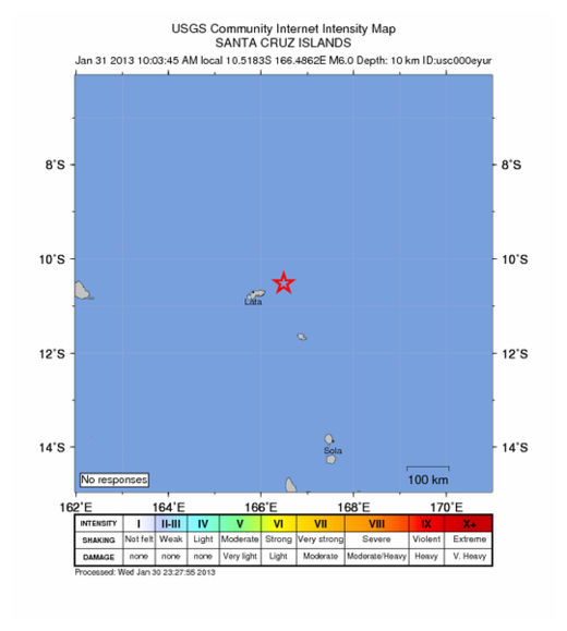
Earthquake Magnitude 6.2 - ENE of Lata, Solomon Islands

Solomon Quake_300113
© USGS
Event Time
2013-01-30 23:03:45 UTC
2013-01-31 10:03:45 UTC+11:00 at epicenter

Location

10.518°S 166.486°E depth=10.0km (6.2mi)

Nearby Cities
74km (46mi) ENE of Lata, Solomon Islands
559km (347mi) N of Luganville, Vanuatu
726km (451mi) E of Honiara, Solomon Islands
822km (511mi) NNW of Port-Vila, Vanuatu
1153km (716mi) N of We, New Caledonia

Bizarro Earth

USGS: Earthquake Magnitude 6.8 - 43km N of Vallenar, Chile

Image
© USGS
Event Time:
2013-01-30 20:15:43 UTC
2013-01-30 17:15:43 UTC-03:00 at epicenter

Location:
28.181°S 70.800°W depth=45.7km (28.4mi)

Nearby Cities:
43km (27mi) N of Vallenar, Chile
101km (63mi) SSW of Copiapo, Chile
196km (122mi) NNE of La Serena, Chile
203km (126mi) NNE of Coquimbo, Chile
585km (364mi) N of Santiago, Chile

Bizarro Earth

USGS: Earthquake Magnitude 5.3 - 263km WNW of Bandon, Oregon

Image
© USGS
Event Time
2013-01-30 03:14:28 UTC
2013-01-29 18:14:28 UTC-09:00 at epicenter

Location:
43.566°N 127.598°W depth=10.2km (6.4mi)

Nearby Cities:
263km (163mi) WNW of Bandon, Oregon
274km (170mi) W of Coos Bay, Oregon
347km (216mi) W of Roseburg, Oregon
364km (226mi) WSW of Corvallis, Oregon
395km (245mi) WSW of Salem, Oregon

Bizarro Earth

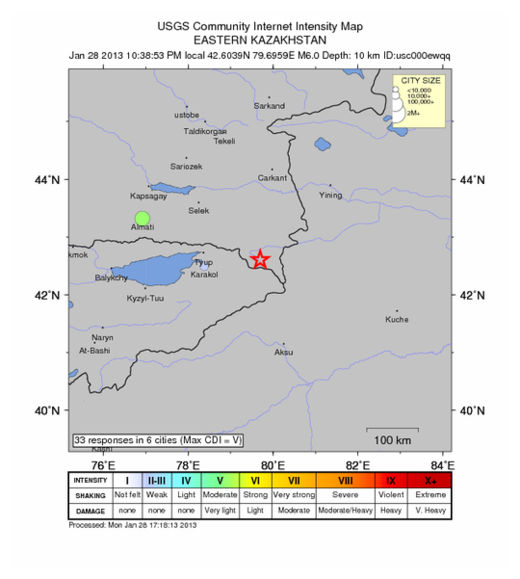
Earthquake Magnitude 6.0 - SE of Kegen, Kazakhstan

Kazak Quake_280113
© USGS
Event Time
2013-01-28 16:38:53 UTC
2013-01-28 22:38:53 UTC+06:00 at epicenter

Location
42.604°N 79.696°E depth=10.9km (6.8mi)

Nearby Cities
60km (37mi) SE of Kegen, Kazakhstan
107km (66mi) E of Karakol, Kyrgyzstan
109km (68mi) E of Tyup, Kyrgyzstan
142km (88mi) ENE of Kyzyl-Suu, Kyrgyzstan
419km (260mi) E of Bishkek, Kyrgyzstan

Technical Details

Moon

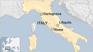
4.8 Earthquake hits near Bologna, Italy

Bologna earthquake
© BBC News
An earthquake has shaken parts of northern Italy, forcing some residents onto the streets.

The magnitude-4.8 quake struck at a depth of 15.5km (9.6 miles) 35km north of the city of Lucca, officials said.

The tremor was felt as far away as Milan and Florence, Italian media say. There were no immediate reports of injuries or damage.

Bizarro Earth

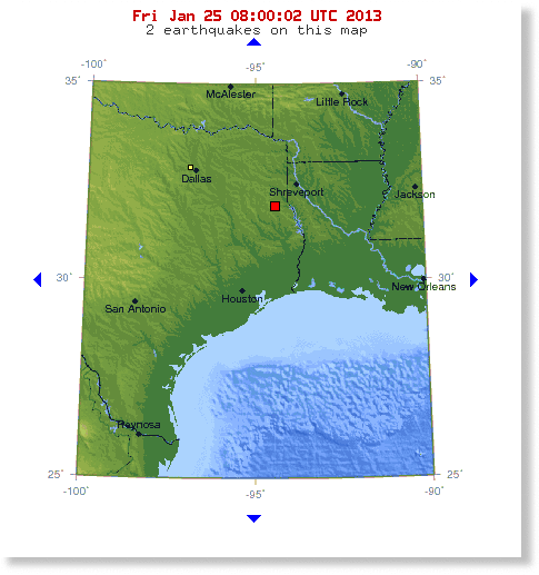
Shallow 4.1 magnitude earthquake rattles East Texas

Image
© USGS
The U.S. Geology Survey confirms a 4.1 magnitude earthquake hit East Texas around 1:01 a.m. The earthquake struck at a depth of 5 km (3.1 miles). Friday morning with an epicenter 2 miles from Timpson, Texas. KSLA News 12 phone lines started ringing after numerous people felt the 'quake from Shelby County all the way to Bossier City. It woke me up out of a dead sleep," said Amanda Jones who lives on Highway 7 E between Center and Joaquin. Jones tells us it felt stronger than the last earthquake that hit East Texas last summer. Jones says she is unsure about damage but will wait until the sun comes up to check.

Jamie Ward in Center, TX tells us her house shook for at least 20 seconds. A man from Carthage, TX who was working the night shift at a gas plant says "it felt like it was coming from the bottom of my feet up." He described what he felt "like the wind was shaking the travel trailer." He tells us he looked for damage but didn't see any. A woman who lives on W. 70th in Shreveport tells us she was laying in bed when "stuff started shaking." Bossier City resident Sarah Rains, who lives off of Sligo Rd., says she and her roommate felt their trailer shake and thought it might have just been heavy winds. Katy Cash of Keatchie says she felt her house shake but thought she was just imagining it when her chandelier over the dining table started swaying. Katy tells us her mom in Florien, Louisiana also felt it. - KSLA

Bizarro Earth

Earthquake swarm reported near Nevada's Topaz Lake

Image
Sixteen small quakes hit an area near Topaz Lake early Thursday, but there have been no reports of damage or injury. The quakes hit an area southwest of the lake between midnight and 5AM. They ranged from 1.1 to 3.7 in magnitude, and were between three and nine kilometers deep. Another handful of small quakes hit several hours later, in the afternoon and evening. The remote area is about 45 miles southeast of Gardnerville. Another small swarm hit an area about 20 miles west northwest of Donner Lake between 5:45AM and 6:15AM Thursday. They ranged between 0.5 and 2.1 in magnitude, with no reports of damage or injury. - KOLOTV

Bizarro Earth

10 volcanic earthquakes rattle Philippines's Taal Volcano: Activity increases in the last 24 hours

Image
The Philippine Institute of Volcanology and Seismology said Tuesday the seismic activity of Taal Volcano in Batangas province has increased in the past 24 hours. Phivolcs Director Renato Solidum, Jr. said the agency has recorded 10 volcanic quakes from 7 a.m. Monday to 7 a.m. Tuesday. But Solidum said no steaming has been observed in the past 24 hours and water temperature at the main crater lake decreased from 31.7 to 30.9 degrees Celsius.

The Phivolcs chief noted the volcano's Alert Level 1 will be maintained as "10 volcanic quakes are still appropriate for a volcano that is under abnormal level." He said that a volcano under Alert Level 1 means that abnormal volcanic activities are observed, though a hazardous eruption is not imminent. Since January 18, Solidum said Taal Volcano was relatively calm, with its seismic network recording "zero to eight" volcanic earthquakes in a day. - MST