Earthquakes
S


Bizarro Earth

Mysterious shaking in Morristown, Tennessee

Image
Late Tuesday afternoon dozens of concerned neighbors called Hamblen County 911 to report the earth shaking and the sound of a large blast.

At first the the US Geological Survey reported there was no earthquake in the area.

That prompted local emergency management officials to spend Wednesday looking at other options.

10News spoke with TDEC (Tennessee Department of Environmental Conservation) who ruled out fracking or quarry activity.

Then, we checked with the University of Memphis Center for Earthquake Research and Information, sponsored by the USGS.

Geologist Gary Patterson went and pulled the records from sensors on Tuesday and says he could see activity consistent with an earthquake or quarry blasting.

Emergency Managment Agency Director Chris Bell says there was no licensed blasting in the Hamblen County area on Tuesday.

Bizarro Earth

USGS: Earthquake Magnitude 6.6 - 134km WSW of Druzhina, Russia

Image
© USGS
Event Time:
2013-02-14 13:13:53 UTC
2013-02-15 01:13:53 UTC+12:00 at epicenter

Location:
67.580°N 142.593°E depth=10.1km (6.3mi)

Nearby Cities:
134km (83mi) WSW of Druzhina, Siberia
860km (534mi) NE of Markha, Russia
866km (538mi) NE of Yakutsk, Russia
979km (608mi) NNW of Magadan, Russia
2973km (1847mi) NNE of Ulaanbaatar, Mongolia

Radar

8 injured, houses damaged in southwest Colombia earthquake

Image
© ElTiempo
Contrary to a statement by President Juan Manuel Santos, eight people have been injured and more than a 100 houses have been damaged in an M7.0 earthquake that hit Colombia Saturday morning.

According to the country's disaster management unit, six people were injured in the El Charco municipality in Nariño, the department where the earthquake took place.

Additionally, the unit's director, Carlos Marquez, said that 143 houses were damaged.

The damages were reported as far as cities as Bogota, more than 500 miles from the earthquake's epicenter, where some buildings were left without windows or cracks appeared in walls.

Shortly before the official report on injuries and damages, Santos claimed there had been no injuries and the material damage was "marginal."

The earthquake was felt in neighboring countries like Ecuador and Peru.

The strong earthquake is the second in the region in half a year; in September last year, a M7.3 earthquake shook the city of Popayan.

Bizarro Earth

USGS: Earthquake Magnitude 6.9 - NNE of Yacuanquer, Colombia

Columbia Quake_090213
© USGS
Event Time
2013-02-09 14:16:09 UTC
2013-02-09 09:16:09 UTC-05:00 at epicenter

Location
1.167°N 77.384°W depth=153.8km (95.6mi)

Nearby Cities
5km (3mi) NNE of Yacuanquer, Colombia
12km (7mi) WSW of Pasto, Colombia
17km (11mi) SE of Sandona, Colombia
27km (17mi) ENE of Tuquerres, Colombia
199km (124mi) NE of Quito, Ecuador

Technical Details

Attention

State of disaster declared on Santa Cruz islands

Image
The Government today has officially declared a State of Disaster for Santa Cruz Islands in Temotu Province following Wednesday's deadly 8.0 magnitude quake and subsequent tsunami that claimed lives and property.

The Minister for Environment, Climate Change, Disaster Management and Meteorology, Hon Bradley Tovusia made the declaration following a decision reached by the National Disaster Council on February 7.

Bizarro Earth

More volcanic activity in Solomons quake zone

The National Disaster Management Office in Solomon Islands says volcanic activity has increased on an island in Temotu province since the magnitude 8.0 earthquake two days ago.

Sipuru Rove says the uninhabited island of Tinakula, which is about 50 kilometres north of Lata, has being making loud and strange sounds.

He says help and information is needed from technical experts to assess the risk posed to the local community by the volcano as they are worried an eruption could be near.
"The volcanic activity on one of the islands that is off Lata is alarming at the moment. And this will really require scientific special people to assist us in assessing this volcanic activity which is beginning to be abnormal."
Sipuru Rove says there are also significant aftershocks which meant a plane with supplies and medical staff couldn't land and was forced to return to Honiara.

Bizarro Earth

What caused the Solomon Islands earthquake & tsunami?

Solomon Quake
© U.S. Geological SurveyA map showing the intensity of shaking caused by a magnitude 8.0 earthquake in the Solomon Islands.
The deadly earthquake and tsunami that hit the Solomon Islands today struck along a subduction zone, the same geologic setting responsible for the world's most powerful earthquakes.

In a subduction zone, two of Earth's tectonic plates meet and one slides beneath the other into the mantle, the deeper layer beneath the crust. The Solomon Islands sit above the collision between the Australia and Pacific plates. In the region of today's magnitude-8.0 earthquake, the Australia plates dives beneath the Pacific plate toward the east-northeast at a geologically speedy 3.7 inches (94 millimeters) per year, according to the Incorporated Research Institutions for Seismology (IRIS).

The earthquake hit at a depth of 17.8 miles (28.7 kilometers) and was the second-largest earthquake in the Solomon Islands region in almost 40 years, IRIS said in a statement. Several aftershocks followed; the largest measured magnitude 6.6, according to the U.S. Geological Survey (USGS).

The tsunami generated by the quake, reported as 3 feet (0.9 meters) in height, hit villages on Santa Cruz Island, destroying structures and homes, according to news reports. A tsunami watch was issued for Australia, Indonesia and New Zealand, but not for the rest of the Pacific, according to the West Coast and Alaska Tsunami Warning Center.

Bizarro Earth

USGS: Earthquake Magnitude 7.0 - 27km NNW of Lata, Solomon Islands

Image
© USGS
Event Time:
2013-02-06 01:54:15 UTC
2013-02-06 12:54:15 UTC+11:00 at epicenter

Location:
10.479°S 165.772°E depth=9.8km (6.1mi)

Nearby Cities:
27km (17mi) NNW of Lata, Solomon Islands
579km (360mi) NNW of Luganville, Vanuatu
648km (403mi) E of Honiara, Solomon Islands
848km (527mi) NNW of Port-Vila, Vanuatu
1166km (725mi) N of We, New Caledonia

Blue Planet

Small tsunami hits Solomons after major quake

Image
© Hugh Gentry/ReutersThe Pacific Tsunami Warning Centre in Hawaii has issued an alert after a quake off the Solomon Islands.
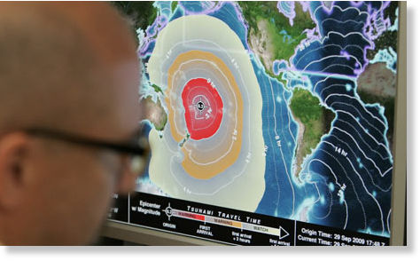
Sydney - A small tsunami hit the Solomon Islands on Wednesday after a major 8.0 magnitude undersea earthquake sparked a tsunami warning for several South Pacific island nations and placed many more nations including Australia and Indonesia on alert.

The quake struck at a very shallow depth of only five km (three miles) and was located 340 km (211 miles) east of Kira Kira in the Solomons, the Pacific Tsunami Warning Center in Hawaii said.

The center said a tsunami measuring 0.9 metres (three feet) hit the Solomons following the quake.

The Solomon Islands Broadcasting Corporation cited a witness who said water was covering an airstrip in Lata, in Temotu province, but there were no immediate reports of damage or casualties.

Solomon Islands police in the small town of Kira Kira, on San Chrostobal island, said they felt the quake, but there were no reports of any damage from the quake or a tsunami.

"We felt the shock. We have warned people to get to higher ground," said local police officer Samuel Tora.

The tsunami warning center gave arrival times from a few minutes to several hours to island nations around the South Pacific.

The warning was issued for the Solomon Islands, Vanuatu, Nauru, Papua New Guinea, Tuvalu, New Caledonia, Kosrae, Fiji, Kiribati, and Wallis and Futuna islands.

Bizarro Earth

Tsunami warning issued after 8.0 earthquake in the South Pacific

Tsunami Warning Sign
© CTV News Canada
A tsunami warning has been issued for a vast region in the South Pacific after an 8.0-magnitude earthquake struck near the Santa Cruz Islands.The earthquake was recorded at a depth of 33 kilometres below the ocean's surface.

The tsunami warning is in effect for a number of South Pacific islands, including Solomon Islands, Vanuatu, Fiji and Papua New Guinea.A tsunami watch is in effect for Australia, New Zealand, Indonesia and a number of islands further away from the epicentre.

Link to updated tsunami watch

More to come...