Earthquakes
S


Target

7.5 earthquake strikes off coast of Alaska; tsunami warning canceled

Image
A strong earthquake struck off the coast of Alaska on Saturday, January 5, 2013.
A tsunami warning was canceled early Saturday for portions of British Columbia, Canada, and southeastern Alaska, officials said.

The warning was issued following a 7.5-magnitude earthquake that struck off the coast of Alaska 63 miles west of Craig, a town on Prince of Wales Island, and 208 miles south of the capital of Juneau, the U.S. Geological Survey said.

The size of the temblor, which struck at 3:58 a.m. ET, off the coast of Alaska was downgraded by the USGS from 7.7 to 7.5.

There were no initial reports of damage but the West Coast and Alaska Tsunami Warning Center said a small tsunami of about six inches was observed near the southeastern Alaskan town of Port Alexander on Baranof Island.

A tsunami watch for the coastal areas of the British Columbia-Washington border was also canceled.

Bizarro Earth

Will a megathrust earthquake strike the Northwest U.S. in 2013? Some clues are emerging

Megaquake
© Seattle Pi
There were 4,800 earthquakes in the Northwest in 2012 and a record "episodic tremor and slip" event - a string of deep mini-quakes running from Vancouver Island to below Centralia - over the summer, but does any of that mean we're likely to see the "big one" in 2013?

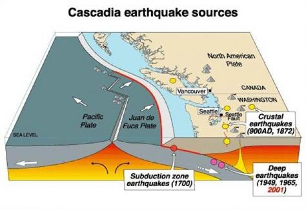
While the devastating megathrust quakes that happen every 300 to 500 years in our neck of the woods (those caused by the Juan De Fuca plate's grinding collision and subduction with the North American plate) are still impossible to predict, some clues may be emerging.

An immature science

Taken together, last year's quakes were "mild" since so few of them were big enough to be felt, said John Vidale, director of the Pacific Northwest Seismic Network.

The biggest and most interesting quake of the year struck under Victoria, B.C., last week. It was a magnitude 4 temblor and resembled in depth and fault the magnitude 6.8 Nisqually quake that damaged Seattle and shook the region in 2001, he said.It was felt and reported to the network's webpage by about 800 people.

He added that a string of unusual quakes around the globe has the seismic community baffled. A big earthquake off the coast of Sumatra in the Indian Ocean six months ago was "very strange" because of its size and distance from the plate boundary.It showed "we can get earthquakes we really hadn't anticipated," he said.

In the past few years, China got hit with an earthquake on a fault that wasn't mapped, New Zealand suffered a "very rare earthquake" ...
"There's a whole series of events in the last decade that give us the impression that we know less than ever," Vidale said. "We keep thinking that these are the specific risks we need to look out for and then earthquakes happen that aren't the ones we thought were most likely to happen."
Also, a roughly annual seismic event in the Northwest discovered 12 years ago - the "episodic tremor and slip,"or ETS - went wild last summer.

Map

4.8-magnitude quake hits France

Image
A 4.8-magnitude earthquake hit southwest France on early Monday, without reports of casualties, the French Central Earthquake Bureau reported.

The quake occurred at about 0:35 a.m. local time (2335 GMT on Sunday) in the area of Pau, with the epicenter being monitored at 43.18 degrees north latitude and 0.24 degrees east longitude, according to the earthquake bureau.

There have so far been no reports of casualties or property losses.

Bizarro Earth

Don't panic? Preliminary data suggests earthquakes are indeed increasing worldwide

Image
Earthquakes and Volcanic eruptions have always been closely related. For instance, if you look at a map of quakes worldwide and compare it to a map of volcanoes, you'll find that they match closely. Both earthquakes and volcanoes occur at the boundaries of tectonic plates, which make up the Earth's surface. Earthquakes are caused by the release of pressure built up when the plates spread apart or move past each or under each other. In slightly more complicated ways, magma is generated at most plate boundaries, and this magma rises to the surface to form volcanoes. In recent weeks, earthquakes have exponentially increased in magnitude worldwide, worrying some researchers as they provide the fuse that ignites volcanoes.

The movement of magma within a volcano causes earthquakes, usually small ones. Earthquakes are also caused by adjustments to the flanks of volcanoes and the plates under volcanoes.

For decades, a source of powerful earthquakes and volcanic activity on the Pacific Rim was shrouded in secrecy, as the Soviet government kept outsiders away from what is now referred to as the Russian Far East.

In the last 20 years research has shown that the Kamchatka Peninsula and Kuril Islands are a seismic and volcanic hotbed, with a potential to trigger tsunamis that pose a risk to the rest of the Pacific Basin.

Comment: Something Wicked This Way Comes


Radar

5.5 magnitude earthquake strikes off Japan

Tokyo - A 5.5-magnitude earthquake struck off the northeast coast of Japan today, the United States Geological Survey (USGS) reported.

The quake hit at depth of 40 kilometres at 11:59 pm (1459 GMT Saturday), about 123 kilometres east of the northern city of Sendai, the USGS said. There were no immediate reports of damage.

A powerful 7.3-magnitude undersea quake off the northeast coast earlier this month triggered a one-metre-high tsunami but no reports of fatalities.

In March last year a devastating earthquake and tsunami in the same area left some 19,000 people dead or missing and crippled the Fukushima nuclear power plant in the world's worst atomic disaster in 25 years.

Radar

5.8 magnitude earthquake strikes Pakistan and Afghanistan

Kabul - A 5.8-magnitude earthquake struck the Hindu Kush region of Afghanistan Saturday, the United States Geological Survey (USGS) said, with the quake felt in the capital Kabul and parts of Pakistan.

The earthquake struck in the late evening at a depth of 115 kilometres (70 miles), some 140 kilometres north of Afghanistan's eastern city of Jalalabad and 130 kilometres west of Chitral in neighbouring Pakistan.

There were no immediate reports of casualties or damage but shaking was felt in Kabul, 180 kilometres away, as well as in northwest Pakistan and the Pakistani capital Islamabad.

Northern Afghanistan is frequently hit by earthquakes, especially in the Hindu Kush mountain range, which lies near the collision of the Eurasian and Indian tectonic plates.

Two quakes in June triggered landslides that killed at least 75 villagers.

Source: Agence France-Presse

Radar

Magnitude 5.5 earthquake at Bio-Bio, Chile, 26 December 2012

Image
© neic.usgs.gov
Magnitude: 5.5

Date-Time: Wednesday, December 26, 2012 at 13:17:56 UTC

Location: 37.281°S, 73.363°W

Depth: 24.7 km (15.3 miles)

Region: BIO-BIO, CHILE

Distances:
11 km (6 miles) WSW of Arauco, Chile

19 km (11 miles) NNW of Curanilahue, Chile

33 km (20 miles) SW of Lota, Chile

40 km (24 miles) NNE of Lebu, Chile
Location Uncertainty: horizontal +/- 19.7 km (12.2 miles); depth +/- 5.1 km (3.2 miles)

Parameters: NST=315, Nph=330, Dmin=283.9 km, Rmss=0.62 sec, Gp= 68°,

M-type=body wave magnitude (Mb), Version=B

Source:
Magnitude: USGS NEIC (WDCS-D)

Location: USGS NEIC (WDCS-D)
Event ID: usc000eg5v

Bizarro Earth

USGS: Earthquake Magnitude 6.8 - SSW of Sola, Vanuatu

Vanuatu Quake_211212
© USGS
Event Time
2012-12-21 22:28:09 UTC
2012-12-22 09:28:09 UTC+11:00 at epicenter

Location

14.382°S 167.260°E depth=207.9km (129.2mi)

Nearby Cities
63km (39mi) SSW of Sola, Vanuatu
127km (79mi) N of Luganville, Vanuatu
387km (240mi) NNW of Port-Vila, Vanuatu
723km (449mi) N of We, New Caledonia
863km (536mi) N of Dumbea, New Caledonia

Technical Details

Bizarro Earth

Earthquake Magnitude 6.1 strikes off coast of Sulawesi, Indonesia

Image
© USGS
A strong 6.1-magnitude earthquake struck off the coast of central Indonesia Monday, the US Geological Survey said, sending panicked people rushing into the streets but there was no tsunami alert. The quake struck at 0916 GMT more than 160 kilometers (99 miles) south-southeast of Gorontalo in central Indonesia's Sulawesi Island at a depth of 18 kilometers. The Indonesian Meteorology, Climatology and Geophysics agency (BMKG) measured it at 6.0 at a depth of 10 kilometers. "The epicenter was in the sea but it doesn't have the potential to trigger a tsunami," BMKG official Agung Utomo told AFP. "We haven't received any report of damage so far."

The National Disaster Mitigation Agency said the ground shook for several seconds. "The quake was quite strong and all the guests here - about 30 people - panicked and ran out into the street," said Rudi Gowarno, manager of Ramayana hotel in the town of Luwuk. Indonesia sits on the Pacific "Ring of Fire" where continental plates collide, causing frequent seismic and volcanic activity. A deep 6.0 magnitude also earthquake struck the New Britain region of Papua New Guinea on December 15th. - Times of India

USGS data

Bizarro Earth

USGS: Earthquake Magnitude 6.3 - 263km SSW of Avalon, California

Image
© USGS
Event Time:
2012-12-14 10:36:02 UTC
2012-12-14 02:36:02 UTC-08:00 at epicente

Location:
31.213°N 119.560°W depth=11.3km (7.0mi)

Nearby Cities:
263km (163mi) SSW of Avalon, California
269km (167mi) WSW of Rosarito, Mexico
276km (171mi) WSW of Imperial Beach, California
277km (172mi) SW of Coronado, California
746km (464mi) WSW of Phoenix, Arizona