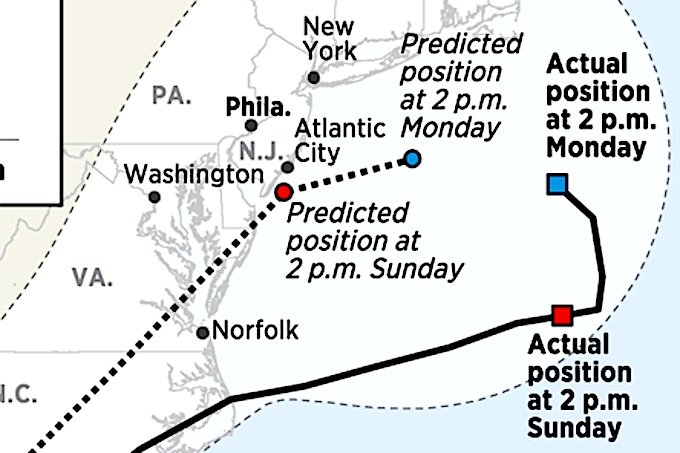
© unknownPredicting Hermine's path
As late as Sunday morning, meteorologists were warning that Tropical Storm Hermine could wreak havoc along the New Jersey Shore. Yet the promised storm stayed far offshore, kicking up little more on land than some wind and minor flooding -- and complaints from frustrated beach-goers and merchants. What happened?
The short answer: while the science of storm tracking has improved steadily in recent years, it remains subject to a fair amount of uncertainty. On average, the
errors in forecasting a storm's location increase by 40 to 50 nautical miles for every day in advance of the point in time that is being predicted, said James L. Franklin, a meteorologist at the National Hurricane Center in Miami. Looking two days out, forecasts can be off by up to 80 to 90 nautical miles in either direction, on average. Three days, 120 miles or more. That is dramatically better than what forecasters achieved several decades ago, but it is still enough to spell the difference between predicting flooded streets or expecting a relatively normal day.
"Errors grow with time," said Franklin, branch chief for the center's hurricane specialist unit. Accuracy in predicting a storm's position
depends on two main things: the computer
models that perform sophisticated calculations about future weather, and the
quality of the information — such as initial temperature, air pressure, humidity, and wind speed — that is fed into those models.
The various computer models treat the atmosphere as a
vast, three-dimensional grid, dividing it into stacks of flattened, squarish sections that are generally a few miles across and several hundred feet thick, said Christopher A. Davis, a senior scientist at the National Center for Atmospheric Research in Boulder, Colo. Using initial measurements of temperature, humidity, and other conditions in each section of atmosphere, the
models calculate the rates of change for each condition over time, using formulas called differential equations.
But since
most of the Earth's atmosphere is over water, there is no direct way to measure the initial conditions in those areas, short of sending up the occasional weather balloon. "We don't know what the pressure is in every spot, because we don't have a barometer everywhere," said the hurricane center's Franklin.
That means scientists must
gauge these conditions indirectly, using satellites to measure different
wavelengths of radiation that are absorbed at each level of the atmosphere. Certain wavelengths of energy are absorbed by water vapor, for example, enabling scientists to generate a value for the humidity in each section of air, Davis said.
Satellite measurements have been steadily improving with time, and they are being taken at higher resolution — meaning for smaller sections of the atmosphere, Davis said. Also, more countries have launched satellites. "Which brings up the importance of data-sharing across political boundaries," said Davis, director of the Mesoscale and Microscale Meteorology Laboratory at the research center in Boulder. The models have improved as well, largely due to faster computers. Scientists also have gotten better at "assimilating" the data into the models, Davis said.
A quarter-century ago, it was common for hurricane trackers to be
off by 200 miles in either direction when predicting a storm's path two days in advance. That is more than twice the typical 80-mile error of today when predicting the path two days out.
Some of the forecasts for Hermine were off by a bit more than average.Last week, on
Friday afternoon, the National Hurricane Center predicted that by 2 p.m. Saturday, the storm would be within
50 nautical miles of the North Carolina coast. In fact, it
ended up about 90 nautical miles east of the coast — well within normal error for a day in advance.But by Sunday, something changed. In that same Friday forecast, the center's meteorologists had predicted that by 2 p.m. Sunday, the storm would be about
100 miles east of the Maryland coast.
Yet in fact, it traveled 168 nautical miles east and a little south of the forecasted location — well above the average two-day error of 80.
"That made all the difference in terms of impacts along the coast," Franklin said. The hurricane center looks at a half-dozen models to predict a storm's path, and it uses four or five models to predict a storm's intensity, he said. Most of the forecast models had Hermine stalling closer to the coast than it did, though it is not entirely clear why.
Franklin speculated that the models overestimated the interaction between Hermine and a "mid-latitude upper-level low" pressure system. Bottom line: there was the usual public grumbling about the accuracy of weather prediction, an extremely challenging task. But the Jersey Shore was spared.
Comment: Forecast Prediction: Meteorologists will always 'weather' the storm!