Midwest Impacts
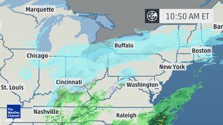
The back edge of the snow will pull eastward Thursday through the Ohio Valley, including a swath from eastern Missouri through downstate Illinois, Indiana, southern Michigan, Ohio, Kentucky and northern Tennessee.
Meanwhile, as the body of Hercules' snow moves east, heavy lake-effect snow will set up off Lake Superior, Lake Michigan and Lake Huron on Thursday.
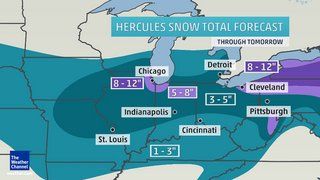
The Lake Michigan snow band will likely target the cities of Milwaukee and Chicago for a time before swinging into the more conventional northwest Indiana snowbelts. Additional accumulations from the lake effect could push snow totals past the one-foot mark in a rather small area, but that small area could be home to several million people.
Otherwise, a narrow swath of six inches or more of snow (including what's already fallen) appears likely across the southern Great Lakes region through Thursday.
Lighter amounts of generally five inches of snow or less are expected from Missouri into Ohio Valley. Accumulations of at least one inch are also possible over parts of Kentucky and northern Tennessee.
Meanwhile, the subtropical branch of the jet stream will start to become active over the Gulf of Mexico with an area of rain expanding along the Gulf Coast. This should help to trigger the development of a coastal low off the Mid-Atlantic coast Thursday, just as the Midwestern system spreads into the Northeast.
Coastal Storm Emerges
Thursday into early Friday the northern and southern weather disturbances will join forces to form a single - and much more powerful - low-pressure system.
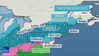
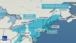
The track of the low-pressure center will stay well offshore - but not far enough offshore to prevent significant snowfall accumulations in the Northeast. The energy from the northern system will allow snow to fall well to the northwest of the offshore low-pressure center across much of New York state and parts of Vermont, New Hampshire, Massachusetts and northern Pennsylvania. Meanwhile, with the low staying offshore, warm air will not have much success intruding into the coastal Northeast, so even coastal areas from New York City northward will see a mostly snow event.
An initial band of light-moderate snow Thursday from New York state and northern Pennsylvania to New England will give way to a more expansive area of snow by Thursday afternoon and evening over much of the Northeast from West Virginia and Maryland to southern Maine.
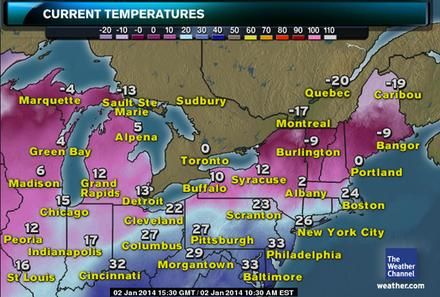
Given widespread temperatures in the teens and 20s, this will be a relatively dry, powdery snow with an added "fluff factor" - meaning deeper snow accumulations than you'd see from a wetter, gloppier snow. Toward the later stages of this snow event, temperatures will plunge even further on Friday, possibly flirting with zero in areas away from the immediate coast.
The track of the surface low pressure center, in concert with high pressure over eastern Canada, will also put areas from the Jersey Shore to southern and eastern New England into a zone of strong north to northeast winds Thursday into early Friday. This will lead to significant blowing and drifting snow and poor visibility, particularly in outlying areas, as the powdery snow is blown about. For coastal southern New England and Long Island, blizzard or near-blizzard conditions may develop as winds approach or exceed 35 mph later Thursday into Friday.
The National Weather Service has issued blizzard warningsfor Long Island, the south shore of Massachusetts, and Cape Cod.
As a result of the blowing snow and very low temperatures, road-clearing efforts will be very difficult. Road salt and chemicals lose much of their effectiveness when temperatures drop into the single digits or lower.
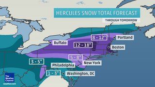
As you can see in the map at right, the heaviest snow accumulations are expected roughly along the Interstate 90 corridor from northeast Ohio into New York and southern New England, where over a foot of total snow is possible.
At least five inches of snow is expected along the heavily populated New York - Philadelphia corridor.
Farther south, lighter snowfall is expected across the rest of the Mid-Atlantic region, including Baltimore and Washington, D.C. Here too, blustery winds and falling temperatures will hamper road crews, but not to the same extent as areas farther north.
This winter storm is expected to exit the East Coast by Friday afternoon. Expect major flight delays at the major Northeast hubs from late Thursday into early Friday, and challenging winter driving conditions from Thursday into Friday.
In addition to the snow threat, there should be some coastal flooding at high tide for the east coast of New England due to strong onshore winds Thursday and Friday. Beach erosion and flooding of vulnerable coastal roads can be anticipated along with freezing spray from breaking waves.
Bottom Line
- Light to moderate snowfall from the Ohio Valley into the southern Great Lakes.
- Lake enhancement and subsequent lake-effect snow will boost snow amounts in the Chicago and Milwaukee metropolitan areas.
- Light snow accumulation possible as far south as Nashville.
- Swath of heavier snowfall from western New York to much of southern New England with amounts locally exceeding one foot.
- Gusty winds and cold temperatures will lead to blowing and drifting snow, especially for the coastal Northeast, with blizzard conditions possible.
- Minor to moderate coastal flooding for the east coast of New England at high tide cycles midday Thursday, Thursday night, and midday Friday.
Weather Channel video coverage here.


This is odd. The heavy snow is hitting New England but the temperatures are very low. Where I am it's 5F or -15C in the early evening. Usually the temps are much warmer when there is a big snowstorm, more like 25 to 35F. I really can't remember heavy snow with extreme cold, but the meteorologists don't seem to be acting like it's unusual.