Volcanoes
S


Bizarro Earth

China volcano shows signs of unrest

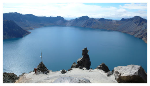
Changbaishan Volcano
© Jiandong XuChangbaishan Volcano.
A very hazardous volcano at the border of China and North Korea is growing more active, and might erupt in the next few decades, researchers studying the area say.

About 1,100 years ago, the Changbaishan volcano in northeastern China erupted, shooting superheated flows of ash and gas up to 30 miles (50 kilometers) away and blasting a 3-mile-wide (5 km) chunk off the tip of the volcano. The explosion, known as the Millennium eruption because it occurred close to the turn of the first millennium, was one of the largest volcanic events in the last 2,000 years.

Since the Millennium eruption, Changbaishan has seen three smaller eruptions, the most recent of which took place in 1903. Starting in 1999, driven by signs of resumed activity, scientists established the Changbaishan Volcano Observatory.

Now, data collected over the past 12 years suggest that changes in seismic activity, ground deformation and gas emissions all spiked during a brief period of heightened activity from 2002 to 2006. This suggests the magma chamber beneath Changbaishan has awakened, researchers studying the volcano say.

The researchers saw the number of earthquakes increase dramatically during this burst of activity. From 1999 to 2002, and from 2006 to 2011, researchers detected seven earthquakes per month. However, from 2002 to 2006, this rate increased to 72 earthquakes per month, peaking in November 2003, which saw 243 events. Most of these quakes are tied to a region 3 miles beneath the volcanic crater that has risen slowly over the years, which suggests magma is creeping upward.
Alarm Clock

Volcano on Pacific Ring of Fire erupts

A volcano has erupted on Indonesia's Sumatra island, spewing thick grey smoke up to 1.5 kilometres into the sky.

Monitoring official Suparno says Mount Marapi's eruption on Wednesday is its strongest since August last year, when its status was raised to level three out of four.

Bizarro Earth

Recent unrest of Changbaishan volcano, northeast China: A precursor of a future eruption?

Image
Roughly 1,100 years ago, the Changbaishan volcano that lies along the border between northeastern China and North Korea erupted, sending pyroclastic flows dozens of kilometers and blasting a 5-kilometer (3-mile) wide chunk off of the tip of the stratovolcano. The eruption, known as the Millennium eruption because of its proximity to the turn of the first millennium, was one of the largest volcanic events in the Common Era. In the subsequent period, there have been three smaller eruptions, the most recent of which took place in 1903.

Starting in 1999, spurred by signs of resumed activity, scientists established the Changbaishan Volcano Observatory, a network to track changing gas compositions, seismic activity, and ground deformation. Reporting on the data collected over the past 12 years, Xu et al. find that these volcanic indices each leapt during a period of heightened activity from 2002 to 2006.

The authors find that during this brief active period, earthquake occurrences increased dramatically. From 1999 to 2002, and from 2006 to 2011, they registered 7 earthquakes per month using 11 seismometers. From 2002 to 2006, this rate increased to 72 earthquakes per month, peaking in November 2003 with 243 events. Further, tracking the source of the earthquakes, the authors tie the bulk of the events to a region located 5 kilometers (3 miles) beneath the volcanic caldera, a source that slowly crept upward throughout the study period, suggestive of an ongoing magmatic intrusion. Gas composition measurements collected from hot springs near the volcano showed spikes in carbon dioxide, hydrogen, helium, and nitrogen gases, which the authors suggest could be related to magmatic outgassing. Ground deformation studies, too, show a brief period of rapid expansion.

Bizarro Earth

Mud volcano erupts in Azerbaijan - Colombian volcano awakening after 86 years

Image
Arif Huseynov: "The Volcano was too powerful at the beginning and the mud covered more than 2 ha of the area"

Baku. Kamala Guliyeva - Lokbatan mud volcano erupted in the morning has weakened, Executive of Mud Volcanism Department under the Geology Institute of the Azerbaijan National Academy of Sciences Arif Huseynov told APA.

Huseynov said that the eruption process is being studied. The volcano accompanied by a rumble at 05.00 spew flames at 09.00: "According to the preliminary observations, the eruption was powerful and mud spread across the area of more than 2 ha. The exact information will be announced after the measurements. But this eruption was more powerful than the eruption in 2010. At that time, the mud covered about 2 ha area."

Husyenov says that no flame is being observed in the area: "The volcano has already weakened. It is not likely to flame again, as it's weakened."

Bizarro Earth

Spain's El Hierro Island has resumed volcanic activity

Image
© IGNLocation of recent quakes
Volcanic activity on Spain's El Hierro Island has resumed far below the Earth's surface in a similar manner to last July, albeit slightly stronger, the director of the National Geographic Institute, or IGN, in the Canary Islands, Maria Jose Blanco, told Efe on Sunday. Blanco said that a peak of seismic activity is under way, a continuation of the volcanic process - a shifting of magma many kilometers (miles) underground - that began in July 2011 which, although the main activity ended at the time with an undersea eruption, that did not mean that the overall activity had come to a definitive conclusion.

The IGN official said that at present it is not expected that the seismic movements that have been registered - which have occurred at depths of some 20 kilometers (about 12.5 miles) - exceed 3.2 on the Richter scale, a fairly low level. Blanco could not specify how long this new round of activity would last, although she did say that seismic peaks like the current one would, in all likelihood, continue to occur. Therefore, she said, the IGN is studying the idea of convening the scientific committee of the Civil Protection Plan for Volcanic Risk in the Canaries after this reactivation in the depths of the El Hierro volcano, where over the past three days more than 330 minor seismic movements have been registered.

Bizarro Earth

Indonesian Volcanos Lokon and Gamalama Eruptions Prompt Government-Issued Warnings

Image
© Antara Photo/Rosa PanggabeanSmoke and ash billow from North Maluku's Gamalama on Sunday.
Two of Indonesia's most active volcanoes erupted on Saturday, prompting the government to issue warnings to populations living near the affected mountains. The National Disaster Mitigation Agency (BNPB) said on Sunday that new eruption started at Lokon in North Sulawesi and Gamalama at Ternate in North Maluku. Lokon generated a 1,500-meter high ash plume and violent strombolian (low-level) activity with some lava flow, while Gamalama produced a shower of ashes that covered the nearby city. Sutopo Purwo Nugroho, a spokesman for BNPB, said on Sunday that Lokon, located in North Sulawesi's Tomohon area, erupted at 7 p.m. on Saturday.

The explosion from the eruption shattered windows of the command post built to monitor the activities of the volcano, he said. The agency, Sutopo said, had issued warnings to local administrations to prepare precautionary measures, and called on people to remain alert. "The residents don't have to be evacuated but they must not do any activities within the range of five kilometers from the volcano," Sutopo said. He said that the BNPB had asked the Tomohon administration to raise the awareness of residents.

Bizarro Earth

Does a dormant undersea volcano lie near Kalpakkam atomic plant?

Image
Even as massive protests have stalled the commissioning of the Kudankulam nuclear plant, activists have now raised concerns over the safety of another nuclear site in Tamil Nadu. The activists claim that there is documentary evidence that the Madras Atomic Power Station (MAPS) in Kalpakkam near Chennai sits near an undersea volcano. They have demanded a thorough investigation of the hazard potential of the volcano by the Department of Atomic Energy (DAE).

In a book first published in Tamil in March and recently translated to English under the title Kalpakkam Nuclear Reactors and Submarine Volcano, V. Pughazhendi and R. Ramesh of the Peoples Movement for Nuclear Radiation Safety have amassed documentary evidence showing that a submarine volcano is located 156 km southeast of Chennai and 100 km east of Pondicherry that could pose a risk to the nuclear plant in Kalpakkam.

Besides the two power plants in Kalpakkam, there are also a fast breeder test reactor, and a fuel reprocessing facility. There will also soon be a 500-MW prototype fast breeder."Volcanic eruptions and submarine landslides have the potential to produce truly awesome tsunami waves," say the authors, who point out that the site of the fast breeder reactor, then under construction, was flooded when a tsunami struck the coast in 2004.

Hourglass

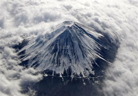
Japan finds another gap in its disaster readiness - Mount Fuji

Mt Fuji
© REUTERS/Toru Hanai/FilesJapan's Mount Fuji, covered with snow and surrounded by cloud, is seen from an airplane in this February 2, 2010 file photo.
When Toshitsugu Fujii became head of a Japanese task force on disaster response at Mount Fuji, he was confronted with a startling oversight. Japan had no plan in place to deal with a disaster in which an earthquake sparks a volcanic eruption at the country's most famous landmark.

Fujii said a tremor "greatly increases" the chance of an eruption in a country that has experienced nearly 12,000 earthquakes since the magnitude 9.0 tremor that led to disaster on March 11, 2011.

"They always forget about the volcanoes," he said. "The government has never included Mt. Fuji in its earthquake scenarios."

Bizarro Earth

Nicaragua volcanic activity: San Cristobal volcano acts up for the second time in a week

Nicaragua boosted its responses to volcanic activity in the northwestern region Saturday, as the San Cristobal volcano acted up for the second time in a week. Authorities installed 43 radio communication stations along the Pacific coast to monitor San Cristobal and another volcano, Telica.

The radio posts aim to "ensure improved monitoring of seismic and volcanic behavior in the area," said civil defense chief Colonel Nestor Solis, enabling authorities to issue more accurate warnings sooner. A number of towns near San Cristobal, located some 135 kilometers (83 miles) northwest of the capital, were evacuated last week after the volcano began rumbling, sending a column of smoke and ash high into the sky, before subsiding.

On Saturday, the 1,745-meter (5,725-foot) tall volcano again spewed "abundant gas emissions moving toward the northeast" and increased seismic tremor and sulfur concentrations, according to the Nicaraguan Institute of Territorial Studies, or INETER.

Bizarro Earth

Guatemala's Volcano Of Fire Eruption Forces Mass Evacuation

Image
© AP Photo/Moises CastilloIn this image with a cell phone plumes of smoke rise from the Volcan de Fuego or Volcano of Fire spews ash seen from Palin, south of Guatemala City, Thursday, Sept. 13, 2012.
Guatemala's head of emergency evacuations says more than 33,000 people are fleeing the eruption of a long-active volcano just outside one of the country's most famous tourist attractions. Sergio Cabanas says the evacuees are leaving some 17 villages around the Volcano of Fire, which sits about 10 miles (16 kilometers) from the colonial city of Antigua.

The agency says the volcano spewed lava nearly 2,000 feet (600 meters) down slopes billowing with ash on Thursday.

Seismologists also say a series of explosions have been coming from the 12,346-foot-high (3,763-meter-high) volcano.