It's also a wet job that exposes the squishy grey matter of the mainstream mindset.
So don your rubber gloves.
And lock the door because this posting contains some very strong images that shouldn't be shared in polite company nor displayed within the confines of a complacent academic ivory tower.
Ready?
The story begins with the ancient island of Taprobane in the Indian Ocean.
Taprobana or Taprobane was the name by which the Indian Ocean island of Sri Lanka was known to the ancient Greeks.The ancient island of Taprobane was known to the Ancient Greeks.
https://en.wikipedia.org/wiki/Taprobana
Reports of the island's existence were known before the time of Alexander the Great as inferred from Pliny.The mainstream mindset has in it's infinite wisdom decreed that Taprobane is Sri Lanka.
...
The name was first reported to Europeans by the Greek geographer Megasthenes around 290 BC.
Herodotus (444 BC) does not mention the island.
The first Geography in which it appears is that of Eratosthenes (276 to 196 BC) and was later adopted by Ptolemy (139 AD) in his geographical treatise to identify a relatively large island south of continental Asia.
https://en.wikipedia.org/wiki/Taprobana
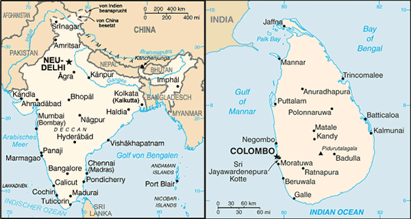
Taprobana or Taprobane was the name by which the Indian Ocean island of Sri Lanka was known to the ancient Greeks.Sri Lanka is a relatively small island that covers about 4º of latitude and 2º of longitude.
...
The identity of Ptolemy's Taprobane has been a source of confusion, but it appeared to be the present day Sri Lanka on the medieval maps of Abu-Rehan (1030) and Edrisi (1154) and in the writing of Marco Polo (1292).
https://en.wikipedia.org/wiki/Taprobana
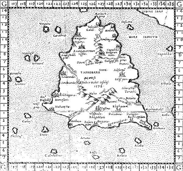
Sri Lanka, officially the Democratic Socialist Republic of Sri Lanka, is an island country in South Asia near south-east India.Whilst Ptolemy's Taprobane is a large island covering about 15º of latitude and 12º of longitude.
Sri Lanka lies on the Indian Plate, a major tectonic plate that was formerly part of the Indo-Australian Plate.
It is in the Indian Ocean southwest of the Bay of Bengal, between latitudes 5° and 10°N, and longitudes 79° and 82°E.
Sri Lanka is separated from the Indian subcontinent by the Gulf of Mannar and Palk Strait.
According to Hindu mythology, a land bridge existed between the Indian mainland and Sri Lanka.
It now amounts to only a chain of limestone shoals remaining above sea level.
Legends claim that it was passable on foot up to 1480 AD, until cyclones deepened the channel.
Portions are still as shallow as 1 metre (3 ft), hindering navigation.
https://en.wikipedia.org/wiki/Sri_Lanka
Clearly, the mainstream claim that Taprobane is Sri Lanka is preposterous nonsense.
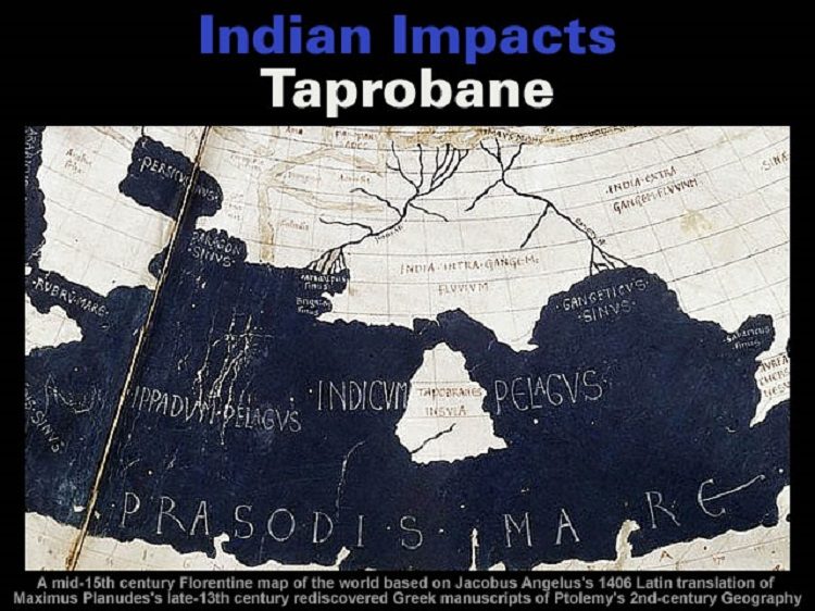
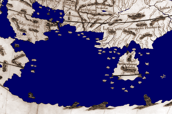
Ptolemy's Indian Ocean map shows Southern India is the detached island of Taprobane.
Evidently, Taprobane collided with Northern India [sometime] during the last 2,000 years.
Taking a closer look at the topography of Indian it appears that the rotation and northward movement of Taprobane was driven by the expansion of [both] the Arabian Sea and the Bay of Bengal.
The expansion of these oceanic basins evidently squeezed and twisted Taprobane in a pincer movement that ultimately created the Western and Eastern Ghats coastal ranges whilst the collision with Northern India resulted in the formation of the Satpuras and Vindhyas ranges.
It's likely the collision of Taprobane with Northern India caused some rivers to be diverted towards the East and the Bay of Bengal.
This goes a long way towards explaining the creation of the Thar desert and the associated collapse of the Indus Valley Civilization.
It also highlights many additional errors in the gigantic Geologic Gospel of Guesses.
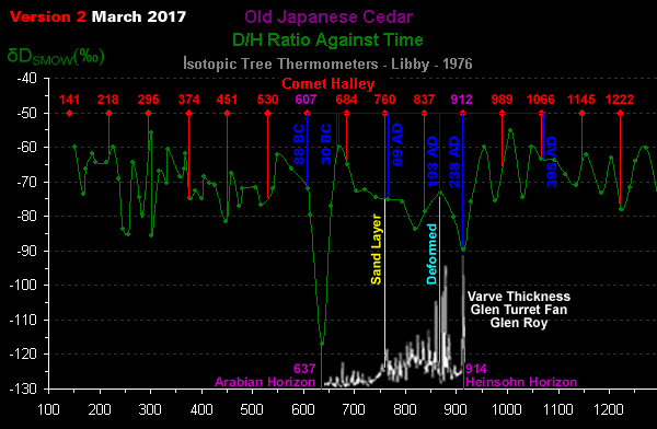
The collision of Taprobane with Northern India probably occurred at the Arabian Horizon [circa 637 CE] because the island was known to the Ancient Greeks.The gigantic Geologic Gospel of Guesses generated by geologists concerning the interior of the Earth is simply staggering considering they've only managed to scratch the surface of the Earth down to 12,262 metres i.e. 0.19% of the Earth's radius.
See: Indian Impacts: Diamonds of the Gods
Please remember to dispose of your rubber gloves thoughtfully...The Indus Valley Civilisation (IVC) was a Bronze Age civilisation (3300 - 1300 BCE; mature period 2600 - 1600 BCE) mainly in the northwestern regions of South Asia, extending from what today is northeast Afghanistan to Pakistan and northwest India.
https://en.wikipedia.org/wiki/Indus_Valley_Civilisation
Gunnar Heinsohn is a German author, sociologist and economist and professor emeritus at the University of Bremen.
...
His work on ancient chronology, focusing on his views on the stratigraphic record, has resulted in some dramatic conclusions.
Heinsohn opined that the currently accepted chronology was entrenched long before the scientific investigation of the past, based on the chronology provided in the Old Testament.
He accused 19th century archaeologists of constructing their chronology around Bible synchronisms and of, more or less, following the chronology recorded by Eusebius in the fourth century, who made use of the histories of Egypt and Mesopotamia as well as the Old Testament.
According to Heinsohn, bible synchronisms led to pharaos Menes and Ramesses II being dated to the 4th millennium and the 14th century, respectively.
As a result, Heinsohn concluded that they created a "phantom" history of two thousand years.
In contrast, Heinsohn interpreted stratigraphic evidence to suggest that Egyptian and Mesopotamian civilizations arose around 1,200 BCE, not 3,200 BCE, as the textbooks say.
https://en.wikipedia.org/wiki/Gunnar_Heinsohn


Reader Comments