Here is today's press release from NOAA, "State of the Climate" for July 2012 where they say:
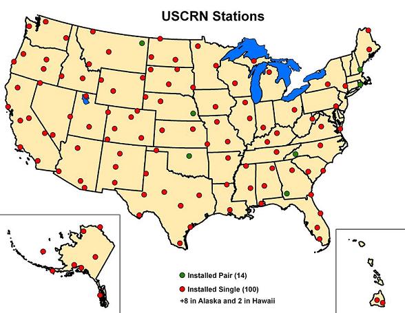
The average temperature for the contiguous U.S. during July was 77.6°F, 3.3°F above the 20th century average, marking the hottest July and the hottest month on record for the nation. The previous warmest July for the nation was July 1936 when the average U.S. temperature was 77.4°F. The warm July temperatures contributed to a record-warm first seven months of the year and the warmest 12-month period the nation has experienced since recordkeeping began in 1895.OK, that average temperature for the contiguous U.S. during July is easy to replicate and calculate using NOAA's USCRN network of stations, shown below:
In case you aren't familiar with his network and why it exists, let me cite NOAA/NCDC's reasoning for its creation. From the USCRN overview page:
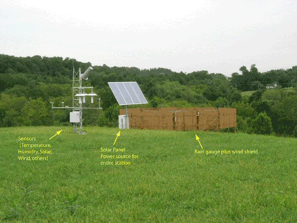
The U.S. Climate Reference Network (USCRN) consists of 114 stations developed, deployed, managed, and maintained by the National Oceanic and Atmospheric Administration (NOAA) in the continental United States for the express purpose of detecting the national signal of climate change. The vision of the USCRN program is to maintain a sustainable high-quality climate observation network that 50 years from now can with the highest degree of confidence answer the question: How has the climate of the nation changed over the past 50 years? These stations were designed with climate science in mind. Three independent measurements of temperature and precipitation are made at each station, insuring continuity of record and maintenance of well-calibrated and highly accurate observations. The stations are placed in pristine environments expected to be free of development for many decades. Stations are monitored and maintained to high standards, and are calibrated on an annual basis. In addition to temperature and precipitation, these stations also measure solar radiation, surface skin temperature, and surface winds, and are being expanded to include triplicate measurements of soil moisture and soil temperature at five depths, as well as atmospheric relative humidity. Experimental stations have been located in Alaska since 2002 and Hawaii since 2005, providing network experience in polar and tropical regions. Deployment of a complete 29 station USCRN network into Alaska began in 2009. This project is managed by NOAA's National Climatic Data Center and operated in partnership with NOAA's Atmospheric Turbulence and Diffusion Division.So clearly, USCRN is an official effort, sanctioned, endorsed, and accepted by NOAA, and is of the highest quality possible. Here is what a typical USCRN station looks like:
A few other points about the USCRN:
- Temperature is measured with triple redundant air aspirated sensors (Platinum Resistance Thermometers) and averaged between all three sensors. The air aspirated shield exposure system is the best available.
- Temperature is measured continuously and logged every 5 minutes, ensuring a true capture of Tmax/Tmin
- All stations were sited per Leroy 1999 siting specs, and are Class 1 or Class 2 stations by that siting standard. (see section 2.2.1 here of the USCRN handbook PDF)
- The data goes through quality control, to ensure an errant sensor hasn't biased the values, but is otherwise unchanged.
- No stations are near any cities, nor have local biases of any kind that I have observed in any of my visits to them.
- Unlike the COOP/USHCN network where they fought me tooth and nail, NOAA provided station photographs up front to prove the "pristine" nature of the siting environment.
- All data is transmitted digitally via satellite uplink direct from the station.
- There are no observer or transcription errors to correct.
- There is no time of observation bias, nor need for correction of it.
- There is no broad scale missing data, requiring filling in data from potentially bad surrounding stations. (FILNET)
- There are no needs for bias adjustments for equipment types since all equipment is identical.
- There are no need for urbanization adjustments, since all stations are rural and well sited.
- There are no regular sensor errors due to air aspiration and triple redundant lab grade sensors. Any errors detected in one sensor are identified and managed by two others, ensuring quality data.
- Due to the near perfect geospatial distribution of stations in the USA, there isn't a need for gridding to get a national average temperature.
The procedure for a CONUS monthly average temperature from USCRN:
- Download each station data set from here: USCRN Quality Controlled Datasets.
- Exclude stations that are part of the USHCN-M (modernized USHCN) or USRCRN-Lite stations which are not part of the 114 station USCRN master set.
- Exclude stations that are not part of the CONUS (HI and AK)
- Load all July USCRN 114 station data into an Excel Spreadsheet, available here: CRN_CONUS_stations_July2012_V1.2
- Note stations that have missing monthly totals data. Three in July 2012, Elgin, AZ, (4 missing days) Avondale, PA,(5 missing days) McClellanville, SC, (7 missing days) and set their data aside to be dealt with separately.
- Do sums and calculate CONUS area averages from the Tmax, Tmin, Tavg and Tmean data provided for each station.
- Do a separate calculation to see how much difference the stations with missing/partial data make for the entire CONUS.
USA Monthly Mean for July 2012: 75.72°F
(111 stations)
USA Monthly Average for July 2012: 75.51°F
(111 stations)
USA Monthly Mean for July 2012: 75.74°F
(114 stations, 3 w/ partial missing data, difference 0.02)
USA Monthly Average for July 2012: 75.55°F
(114 stations, 3 w/ partial missing data, difference 0.04)
Comparison to NOAA's announcement today:
Using the old network, NOAA says the USA Average Temperature for July 2012 is: 77.6°F
Using the NOAA USCRN data, the USA Average Temperature for July 2012 is: 75.5°F
The difference between the old problematic network and new USCRN is 2.1°F cooler.
This puts July 2012, according to the best official climate monitoring network in the USA at 1.9°F below the 77.4°F July 1936 USA average temperature in the NOAA press release today, not a record by any measure. Dr. Roy Spencer suggested earlier today that he didn't think so either, saying:
So, all things considered (including unresolved issues about urban heat island effects and other large corrections made to the USHCN data), I would say July was unusually warm. But the long-term integrity of the USHCN dataset depends upon so many uncertain factors, I would say it's a stretch to to call July 2012 a "record".This result also strongly suggests, that a well sited network of stations, as the USCRN is designed from inception to be, is totally free of the errors, biases, adjustments, siting issues, equipment issues, and UHI effects that plague the older COOP USHCN network that is a mishmash of problems that the new USCRN was designed to solve.
It suggests Watts et al 2012 is on the right track when it comes to pointing out the temperature measurement differences between stations with and without such problems. I don't suggest that my method is a perfect comparison to the older COOP/USHCN network, but the fact that my numbers come close, within the bounds of the positive temperature bias errors noted in Leroy 1999, and that the more "pristine" USCRN network is cooler for absolute monthly temperatures (as would be expected) suggests my numbers aren't an unreasonable comparison.
NOAA never mentions this new pristine USCRN network in any press releases on climate records or trends, nor do they calculate and display a CONUS value for it. Now we know why. The new "pristine" data it produces is just way too cool for them.
Look for a regular monthly feature using the USCRN data at WUWT. Perhaps NOAA will then be motivated to produce their own monthly CONUS Tavg values from this new network. They've had four years to do so since it was completed.
UPDATE: Some people questioned what is the difference between the mean and average temperature values. In the monthly data files from USCRN, there are these two values:
T_MONTHLY_MEAN
T_MONTHLY_AVG
http://www.ncdc.noaa.gov/crn/qcdatasets.html
The mean is the monthly (max+min)/2, and the average is the average of all the daily averages.
UPDATE2: I've just sent this letter to NCDC - to ncdc.info@ncdc.noaa.gov
Hello,
I apologize for not providing a proper name in the salutation, but none was given on the contact section of the referring web page.
I am attempting to replicate the CONUS temperature average of 77.6 degrees Fahrenheit for July 2012, listed in the August 8th 2012, State of the Climate Report here: http://www.ncdc.noaa.gov/sotc/
Pursuant to that, would you please provide the following:
1. The data source of the surface temperature record used.
2. The list of stations used from that surface temperature record, including any exclusions and reasons for exclusions.
3. The method used to determine the CONUS average temperature, such as simple area average, gridded average, altitude corrections, bias corrections, etc. Essentially what I'm requesting is the method that can be used to replicate the resultant 77.6F CONUS average value.
4. A flowchart of the procedures in step 3 if available.
5. Any other information you deem relevant to the replication process.
Thank you sincerely for your consideration.
Best Regards,
Anthony Watts


Having been around remote Fire Weather Stations (RFWS) and their Data in the past, which does not factor well into the NOAA statistical grid, here is a little of what also resides in the US/Canada (not counting Russia/Europe, another northern hemispheric data collection matter). These stations are many and generally (not always) setup to exacting environmental location specifications and standards.
In the U.S. you've got - Remote Automated Weather Stations (RAWS) network (“As of 2002 there were almost 1,900 stations deployed across the conterminous United States, Alaska, and Hawaii") [Link]
Weather Stations and Forecast Regions
The Atlas of Canada
[Link]
What becomes extremely apparent in this region is that from just above latitude Edmonton, Alberta (example) to the Arctic Circle; a vast representation of lands, offers very few data collection points.
In BC for instance, this [Link]gives some idea of just one provinces (off the grid) weather data. These stations represent vast ranges of elevations and aspects and the data is likely very different than those measured for NOAA public release, such as from the airport tarmacs and inner cities.
Think it is likely that if all these data points were taken as a whole (a true 24/7 mean), the picture might look significantly different then what the IPCC likes to pontificate about.