The clouds were bluish-grey with a distinctive cellular pattern of pouches.
They were hanging under another cloud base -- a sure sign of rain to come.
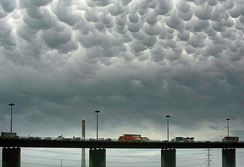
|
| ©Mark Smith |
| Menacing sky: mammatus clouds herald an approaching cold front. |
Weather bureau duty forecaster Geoff Feren said the clouds were different from those usually seen over Melbourne.
"We do see it every now and then, but it's not the most common cloud," he said.
Mr Feren said while these clouds were seen yesterday morning, they can stand out more in the afternoon. "It depends on the lighting, how prominent mammatus is, but especially late in the day when the light is coming through."
"It can often be associated with thunderstorms, but it's not in this case.
"It does mean instability in the mid-to-upper layers of the atmosphere. And it's obviously moist."
The mammatus appeared before a cool change. And although some rain came with it, Mr Feren said most evaporated before hitting the ground.


Melbourne is famous for its capricious weather – most people there tend to dress in a way that makes it easy to adjust to extremely variable temperature and moisture levels. Sometimes this can happen many times a day.
To the west we have a cluster of army bases and research centres – this can be connected.
Also, the “veil” in the area is particularly thin and so all sorts of fun metaphysical things happen there. No wonder that Melbourne is a hub of artistic and brotherhood activity.