Mars, a mixed bag of ancient and modern terrains, lies somewhere in between. Over the years spacecraft have glimpsed ever-finer features in the Martian landscape. These days, the HiRISE camera aboard NASA's Mars Reconnaissance Orbiter (MRO) can pick out objects only 0.3 metres in size; the High Resolution Stereo Camera on the European Space Agency's Mars Express is no slouch either, with a ground resolution of 2 metres.
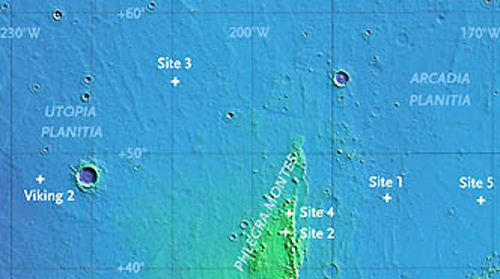
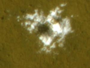
So HiRISE researchers were elated, but not particularly surprised, to discover some small, freshly gouged craters in images taken in 2008. Seen at five sites over a latitude range of 43° to 56° north, the excavations are typically 3 to 6 metres across and a third to two-thirds of a metre deep. One cluster must have appeared sometime between June and August, and a somewhat larger pit showed up between January and September.

Disappearing act
In the months that followed, these snowy splashes gradually faded from view. Water ice isn't stable at the craters' latitudes, so most likely it gradually sublimated, or vaporised, into the atmosphere, leaving behind a veneer of any dust that had been mixed with it.
The disappearing act might also be due in part to a coating of dust blown in from the atmosphere. Either way, notes HiRISE investigator Shane Byrne of the University of Arizona, the icy deposits had to be at least a couple of inches (several centimetres) thick, and they couldn't have been unearthed from more than a foot or two (0.3-0.6 m) down.
Byrne announced these findings on Friday at the Lunar and Planetary Science Conference in The Woodlands, Texas. He points out that prior surveys, particularly one done by the neutron spectrometer aboard NASA's Mars Odyssey orbiter, show that vast reservoirs of ice lay barely buried across most of the planet's polar and mid-latitude regions.
So close
But scientists are only now realising just how near the surface the ice lies - and how easily it can be reached. When NASA's Phoenix lander dropped onto a northern polar plain last May, its braking engine blew off a few inches of loose dirt and revealed slabs of nearly pure ice.
The irony in all this is that the Viking 2 lander, which arrived in September 1976, sits just 800 km southeast of the ice-splashed craterlet shown above, and scientists now realise that a layer of water ice almost certainly lies not far beneath its footpads.
"It's probably just tens of centimetres down," says HiRISE team leader Alfred McEwen. Had Viking's sampling scoop been able to dig a little deeper, he adds, "we might have sampled ice on Mars 30 years ago."
Courtesy of Sky and Telescope magazine


Reader Comments
to our Newsletter