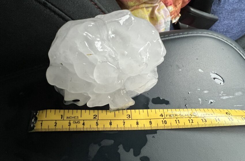
© Matthew WatersA hailstone four inches across that fell near Waco, Tex., on Wednesday.
Hail season is in full force across the Lower 48, and it's no surprise that multiple massive hailstorms have rolled through Texas this week, tossing missiles of ice bigger than softballs out of the sky. What is surprising, however, is where else the enormous hail has been reported — Florida — with several days of back-to-back rotating thunderstorms dropping tennis ball-sized hail and causing damage.
More hail is expected in the days ahead, particularly on Friday, when a level 3 out of 5 enhanced risk of severe weather has been drawn by the National Weather Service Storm Prediction Center for parts of Texas.
April into May marks the climatological peak for severe weather, including tornadoes, in the Lower 48. After a record-active start to the year that's already been responsible for 63 fatalities, there has been a pause for the past week or two. Signs point to that lingering until the second week of May, when dangerous storms could make a swift return.
Texas-sized hailLast weekend began with a round of hailstorms in Texas beneath an upper-level impulse. Baseball- to teacup-sized hail fell on Saturday in Ballinger, Tex., about 50 miles south-southwest of Abilene. Hen-egg-sized hail came down to the southeast in Mason County, and adjacent Gillespie County reported "hail bigger than golf balls but smaller than tennis ball size."
Then another batch of only a few isolated storms formed on Wednesday, again producing baseball-sized hail in the state's Floyd and Taylor counties. Runnels County reported 3½-inch-diameter hail around nightfall, and in the city of Dickens, 50 miles east of Lubbock, hail up to grapefruit size fell. There was "extensive damage to property and vehicles," with "numerous windows broken," according to a storm report filed with the National Weather Service.
Several of the thunderstorms exhibited "hail spikes" on radar, a telltale aberration indicative of monstrous hail. It results when large hail reflects an incoming radar beam toward the ground first before the signal returns to the radar. That results in a longer path taken by the reflected beam en route to the radar, tricking the radar into thinking the precipitation is farther away than it actually is. That results in a spike.
Then activity shifted east toward the Interstate 35 corridor on Wednesday.
The biggest hail fell near Waco, with a report of 4½-inch-diameter hail, again the size of a grapefruit, two miles east of the city.Softball-sized hail also fell in China Spring, on the west side of Waco. That same storm had a history of dropping softball-sized hail in Comanche County to the northwest.
A viral Twitter video emerged of massive hail hitting Dublin, Tex., battering a cow.
The cow reportedly survived.
Additional significant hailstorms are expected in Texas on Friday.
Massive hail in FloridaFlorida is accustomed to afternoon pulse-type thunderstorms this time of year that form along the Sunshine State's daily sea breeze boundaries, but storms this week attained unusual strength. The presence of extra-cold, dry air in place at the high altitudes helped garden-variety storms become particularly severe, and a number of them dropped serious hailstones.
On Monday, Thonotosossa, Fla., in Hillsborough County, about 30 miles east-northeast of Tampa along Interstate 4, received hail up to 3 inches in diameter. That's bigger than a baseball.
Then baseball-sized hail struck Mascotte and near Four Corners in Lake County on Tuesday, which is one county over from Orlando.
Wednesday shared its meteorological malice with Georgia, too, when Bryan County, just west of Savannah, experienced hail up to about tennis ball size. Hail covered the ground like snow in Richmond Hill, Ga., southwest of Savannah.
A number of intense storms in Florida dropped half-dollar to golf-ball-sized hail in Brevard and Palm Beach Counties, in some places piling up a couple of inches high and resulting in a sudden onset of hail fog. That occurs when the freshly fallen ice chills the air below its dew point, causing moisture to condense and form a fog bank.
Tennis-ball-sized hail fell in Marion County near Ocala — representing the third day in a row that the Sunshine State had seen hail of that size.
Maybe when they drop the size of melons, they start to ask questions.