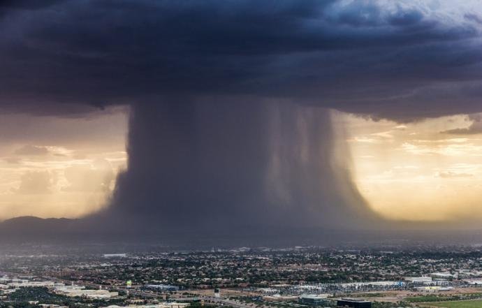
Monday, while covering the effects of these spectacular monsoon related thunderstorms for a local Phoenix television network, helicopter pilot Jerry Ferguson captured an instant of extreme atmospheric action in which a massive microburst was affecting the metro area.
Majestic from the distance, but very intense and damaging on the ground, this spectacle of nature seemed to last forever as described by local residents.
An Inverted Tornado
Microbursts are spectacular but very dangerous downdrafts associated with violent thunderstorms such as the ones travelling across portions of the southwest US this week.
They are occasionally referred to as "inverted tornados" because they actually have the opposite motion of a twister (downward) and can cause surface winds well in excess of 100 mph, the equivalent of at least an EF1 tornado.
The two main mechanisms involved in the formation of a wet Microburst are precipitation and evaporation, with the first of the two having a greater effect on its intensity.
On occasions, a dry version of the phenomenon can form without precipitation reaching the ground, as water evaporates in higher levels of the atmosphere and evaporative cooling causes the denser air to flow downward as a strong draft. The diameter of these very intense downdrafts can vary, but it is usually less than 2.5 miles wide.
With the towering Cumulonimbus growing in size, large amounts of moisture are drawn into the cloud and water drops and hail begin to form and grow in size. When updrafts feeding the cloud get stronger, a tremendous amount of super cooled water droplets mixed with hail remain suspended in the upper portion of the thunderstorm.
Watch below: Timelapse video of the microburst earlier this week shot by Bryan Snider from the vantage point of Phoenix's Sky Harbor International Airport.
When water and hail come crushing down
Even though condensation (water droplet formation) is taking place within the cloud, there are several processes that can simultaneously initiate the opposite mechanism, evaporation.
While persistent strong updrafts continue to feed part of the cloud, water drops and hail will at some point begin to fall on the other, initiating a downdraft which can be enhanced by the entrainment of cooler air from the environment. This downdraft will at some point shut off the updraft causing most of the water and hail stored in the upper portion of the cloud to plummet towards the surface.
The sudden downward surge of air can further be strengthened by evaporative cooling, since the falling rain goes through a drier air layer causing evaporation. This cooler air is now denser and heavier and can help the downdraft become even stronger before reaching the ground.
Once this burst of air impacts the surface it can move in all directions although the point of ground impact is usually the one that experiences the greatest damage.
Microbursts can form in minutes, and some studies suggest that among other factors their strength depends greatly on how high the mixing ratio is and on ice melting, particularly hail, within the cloud.
Forecasting microbursts can be complicated and detecting them within a thunderstorm is also difficult because they are short lived phenomena. Forecasters can have an idea of microburst potential on a given day only a few hours before storm development by assessing how unstable the atmosphere is and examining specific data like precipitable water or dry air in the mid levels of the atmosphere.


Obviously this is a charge induced event.